ATL: ISAIAS - Models
Moderator: S2k Moderators
-
HurricaneFrances04
- Category 2

- Posts: 597
- Joined: Mon Jun 25, 2012 8:09 am
- Location: Fort Lauderdale, Florida
-
TheStormExpert
Re: ATL: INVEST 92L - Models
Now watch the Euro go all out again on it’s 12z run as the others seem to be less enthusiastic on significant development.
2 likes
-
ConvergenceZone
.gif)
- Category 5

- Posts: 5241
- Joined: Fri Jul 29, 2005 1:40 am
- Location: Northern California
Re: ATL: INVEST 92L - Models
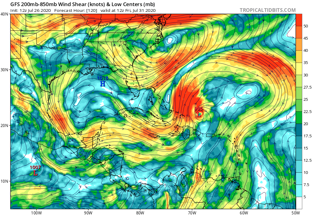
gatorcane wrote:NewEnglandWX wrote:gatorcane wrote:Looks like conditions may not be as favorable in the SW Atlantic as I previously thought for 92l...if 92l even makes it there:
https://i.postimg.cc/GphYddQv/gfs-shear-watl-21.png
Based off of one run? The problem this run is that it accelerates too fast into the dry air and becomes decoupled thus not allowing it to form a ULAC because it stays too weak.
Based also on yesterday’s JMA which showed weakening between hours 168 and 192 in the same general area.
And the only reason is because it's July. Had this been happening in late August, the conditions would be different and we would probably be looking at a cat 4/cat 5 hurricane....
0 likes
-
northjaxpro

- S2K Supporter

- Posts: 8900
- Joined: Mon Sep 27, 2010 11:21 am
- Location: Jacksonville, FL
Re: ATL: INVEST 92L - Models
NewEnglandWX wrote:gatorcane wrote:NewEnglandWX wrote:
Based off of one run? The problem this run is that it accelerates too fast into the dry air and becomes decoupled thus not allowing it to form a ULAC because it stays too weak.
Based also on yesterday’s JMA which showed weakening between hours 168 and 192 in the same general area.
My point is that it's way too early to look at any of the intensity trends. Should've learned that from Gonzalo and Hanna but here you are using the models to predict and storm without an LLC out at 120 something hours. There is a reason the NHC doesn't do cones for invests. Please at least wait until we have a Depression to start doubting the Tropical cyclone.
Preach on!! You are so on point here NewEnglandWX. I could not have said this any better!
0 likes
NEVER, EVER SAY NEVER in the tropics and weather in general, and most importantly, with life itself!!
________________________________________________________________________________________
Fay 2008 Beryl 2012 Debby 2012 Colin 2016 Hermine 2016 Julia 2016 Matthew 2016 Irma 2017 Dorian 2019
________________________________________________________________________________________
Fay 2008 Beryl 2012 Debby 2012 Colin 2016 Hermine 2016 Julia 2016 Matthew 2016 Irma 2017 Dorian 2019
-
HurricaneFrances04
- Category 2
- Posts: 597
- Joined: Mon Jun 25, 2012 8:09 am
- Location: Fort Lauderdale, Florida
Re: ATL: INVEST 92L - Models
It doesn't look like many of the GFS ensembles show much weakening, although they don't really show a major hurricane either. All pretty much show a recurve, some further west than others. Classic EURO vs GFS battle 
0 likes
-
HurricaneFrances04
- Category 2
- Posts: 597
- Joined: Mon Jun 25, 2012 8:09 am
- Location: Fort Lauderdale, Florida
Re: ATL: INVEST 92L - Models
UKMET a smidge closer to Puerto Rico. Shows a strengthening storm. Side note, for some reason the UKMET ensembles haven't updated on Weather Nerds since the 00Z run yesterday for some reason.
NEW TROPICAL CYCLONE FORECAST TO DEVELOP AFTER 42 HOURS
FORECAST POSITION AT T+ 42 : 13.5N 47.8W
LEAD CENTRAL MAXIMUM WIND
VERIFYING TIME TIME POSITION PRESSURE (MB) SPEED (KNOTS)
-------------- ---- -------- ------------- -------------
1200UTC 28.07.2020 48 13.3N 50.0W 1008 33
0000UTC 29.07.2020 60 14.3N 52.6W 1006 38
1200UTC 29.07.2020 72 15.5N 56.3W 1003 43
0000UTC 30.07.2020 84 16.5N 59.3W 999 49
1200UTC 30.07.2020 96 17.7N 62.4W 993 53
0000UTC 31.07.2020 108 19.2N 65.3W 981 64
1200UTC 31.07.2020 120 20.7N 68.3W 975 64
0000UTC 01.08.2020 132 22.6N 71.0W 970 66
1200UTC 01.08.2020 144 24.9N 73.6W 963 74
0 likes

Re: ATL: INVEST 92L - Models
gatorcane wrote:Looks like conditions may not be as favorable in the SW Atlantic as I previously thought for 92l...if 92l even makes it there:
[l]https://i.postimg.cc/GphYddQv/gfs-shear-watl-21.png[/url]
Just remember Dorian last year. When it was Invest 99l all the models had it barely surviving only to then change their tune and flourish in the Bahamas. We have seen this picture many times before. Once Dorian became classified and had an established position models got a better handle and things started to change. Shear forecast are garbage at this point.
Pending the Euro all we know is the models have not wavered on developing a system that may hit the Caribbean and Bahamas and make a close approach to the US.
6 likes
The following post is NOT an official forecast and should not be used as such. It is just the opinion of the poster and may or may not be backed by sound meteorological data. It is NOT endorsed by any professional institution including storm2k.org For Official Information please refer to the NHC and NWS products.
-
MississippiWx

- S2K Supporter
- Posts: 1720
- Joined: Sat Aug 14, 2010 1:44 pm
- Location: Hattiesburg, Mississippi
Re: ATL: INVEST 92L - Models
Just curious, but did any of you pay attention to basically every model missing out on a HURRICANE forming in the Gulf of Mexico this week-even as little as 1-2 days out?
So yeah...I’m sure these 5-6 day model outputs are solid. Until 92L can decide which vort is the dominant one, long range model output is useless.
So yeah...I’m sure these 5-6 day model outputs are solid. Until 92L can decide which vort is the dominant one, long range model output is useless.
11 likes
This post is not an official forecast and should not be used as such. It is just the opinion of MississippiWx and may or may not be backed by sound meteorological data. It is not endorsed by any professional institution including storm2k.org. For Official Information please refer to the NHC and NWS products.
-
TheStormExpert
Re: ATL: INVEST 92L - Models
HurricaneFrances04 wrote:UKMET a smidge closer to Puerto Rico. Shows a strengthening storm. Side note, for some reason the UKMET ensembles haven't updated on Weather Nerds since the 00Z run yesterday for some reason.
NEW TROPICAL CYCLONE FORECAST TO DEVELOP AFTER 42 HOURS
FORECAST POSITION AT T+ 42 : 13.5N 47.8W
LEAD CENTRAL MAXIMUM WIND
VERIFYING TIME TIME POSITION PRESSURE (MB) SPEED (KNOTS)
-------------- ---- -------- ------------- -------------
1200UTC 28.07.2020 48 13.3N 50.0W 1008 33
0000UTC 29.07.2020 60 14.3N 52.6W 1006 38
1200UTC 29.07.2020 72 15.5N 56.3W 1003 43
0000UTC 30.07.2020 84 16.5N 59.3W 999 49
1200UTC 30.07.2020 96 17.7N 62.4W 993 53
0000UTC 31.07.2020 108 19.2N 65.3W 981 64
1200UTC 31.07.2020 120 20.7N 68.3W 975 64
0000UTC 01.08.2020 132 22.6N 71.0W 970 66
1200UTC 01.08.2020 144 24.9N 73.6W 963 74
The 12z UKMET must be the only global model left (at least that I’ve seen) that actually develops 92L into a hurricane.
0 likes
-
TheStormExpert
Re: ATL: INVEST 92L - Models
MississippiWx wrote:Just curious, but did any of you pay attention to basically every model missing out on a HURRICANE forming in the Gulf of Mexico this week-even as little as 1-2 days out?
So yeah...I’m sure these 5-6 day model outputs are solid. Until 92L can decide which vort is the dominant one, long range model output is useless.
The thing is they’re or were developing something significant from 92L only to back off on intensity due to unfavorable atmospheric conditions. I see your point but the atmosphere was more favorable in the Gulf for Hanna than what it likely is for 92L.
0 likes

Re: ATL: INVEST 92L - Models
TheStormExpert wrote:HurricaneFrances04 wrote:UKMET a smidge closer to Puerto Rico. Shows a strengthening storm. Side note, for some reason the UKMET ensembles haven't updated on Weather Nerds since the 00Z run yesterday for some reason.
NEW TROPICAL CYCLONE FORECAST TO DEVELOP AFTER 42 HOURS
FORECAST POSITION AT T+ 42 : 13.5N 47.8W
LEAD CENTRAL MAXIMUM WIND
VERIFYING TIME TIME POSITION PRESSURE (MB) SPEED (KNOTS)
-------------- ---- -------- ------------- -------------
1200UTC 28.07.2020 48 13.3N 50.0W 1008 33
0000UTC 29.07.2020 60 14.3N 52.6W 1006 38
1200UTC 29.07.2020 72 15.5N 56.3W 1003 43
0000UTC 30.07.2020 84 16.5N 59.3W 999 49
1200UTC 30.07.2020 96 17.7N 62.4W 993 53
0000UTC 31.07.2020 108 19.2N 65.3W 981 64
1200UTC 31.07.2020 120 20.7N 68.3W 975 64
0000UTC 01.08.2020 132 22.6N 71.0W 970 66
1200UTC 01.08.2020 144 24.9N 73.6W 963 74
The 12z UKMET must be the only global model left (at least that I’ve seen) that actually develops 92L into a hurricane.
12z ICON and CMC both make it a hurricane as it recurves.
0 likes
Kendall -> SLO -> PBC
Memorable Storms: Katrina (for its Florida landfall...) Wilma Matthew Irma
Memorable Storms: Katrina (for its Florida landfall...) Wilma Matthew Irma
-
TheStormExpert
Re: ATL: INVEST 92L - Models
blp wrote:gatorcane wrote:Looks like conditions may not be as favorable in the SW Atlantic as I previously thought for 92l...if 92l even makes it there:
[l]https://i.postimg.cc/GphYddQv/gfs-shear-watl-21.png[/url]
Just remember Dorian last year. When it was Invest 99l all the models had it barely surviving only to then change their tune and flourish in the Bahamas. We have seen this picture many times before. Once Dorian became classified and had an established position models got a better handle and things started to change. Shear forecast are garbage at this point.
Pending the Euro all we know is the models have not wavered on developing a system that may hit the Caribbean and Bahamas and make a close approach to the US.
I think at this point most of us have amnesia of what happened in prior seasons with prior storms, especially with all that’s been going on this year.
2 likes
-
toad strangler

- S2K Supporter
- Posts: 4546
- Joined: Sun Jul 28, 2013 3:09 pm
- Location: Earth
- Contact:
Re: ATL: INVEST 92L - Models
TheStormExpert wrote:blp wrote:gatorcane wrote:Looks like conditions may not be as favorable in the SW Atlantic as I previously thought for 92l...if 92l even makes it there:
[l]https://i.postimg.cc/GphYddQv/gfs-shear-watl-21.png[/url]
Just remember Dorian last year. When it was Invest 99l all the models had it barely surviving only to then change their tune and flourish in the Bahamas. We have seen this picture many times before. Once Dorian became classified and had an established position models got a better handle and things started to change. Shear forecast are garbage at this point.
Pending the Euro all we know is the models have not wavered on developing a system that may hit the Caribbean and Bahamas and make a close approach to the US.
I think at this point most of us have amnesia of what happened in prior seasons with prior storms, especially with all that’s been going on this year.
You won't ever see me making definitive statements based off one or a few model runs. It makes for just poor understanding of modeling and what their usefulness is. Those doing that who end up being correct are just lucky and learn nothing
4 likes
My Weather Station
https://www.wunderground.com/dashboard/pws/KFLPORTS603
https://www.wunderground.com/dashboard/pws/KFLPORTS603
-
TheStormExpert
Re: ATL: INVEST 92L - Models
toad strangler wrote:TheStormExpert wrote:blp wrote:
Just remember Dorian last year. When it was Invest 99l all the models had it barely surviving only to then change their tune and flourish in the Bahamas. We have seen this picture many times before. Once Dorian became classified and had an established position models got a better handle and things started to change. Shear forecast are garbage at this point.
Pending the Euro all we know is the models have not wavered on developing a system that may hit the Caribbean and Bahamas and make a close approach to the US.
I think at this point most of us have amnesia of what happened in prior seasons with prior storms, especially with all that’s been going on this year.
You won't ever see me making definitive statements based off one or a few model runs. It makes for just poor understanding of modeling and what their usefulness is. Those doing that who end up being correct are just lucky and learn nothing
Well I mean I remember Dorian and it’s effects but I vaguely remember it in its early stages and what models were doing prior to it’s development. Same goes with storms such as Irma, and Matthew.
0 likes
-
HurricaneFrances04
- Category 2
- Posts: 597
- Joined: Mon Jun 25, 2012 8:09 am
- Location: Fort Lauderdale, Florida

-
Aric Dunn
- Category 5
- Posts: 21238
- Age: 43
- Joined: Sun Sep 19, 2004 9:58 pm
- Location: Ready for the Chase.
- Contact:
Re: ATL: INVEST 92L - Models
I just really hope no one is actually taking any model seriously right now.. lol
before Hanna developed ...and every other system this year.. the globals showed almost no development. it was not until after it was an actual TD/TS that the models were finally force-fed data and then they still got intensity wrong.
Hanna was the worst I have seen a long time..
Global models just absolutely refused to acknowledge the surrounding environment and steering.. nothing until it had become a TS..
SO dont even think about taking any of these models right now seriously until it is a well established system.
13 likes
Note: If I make a post that is brief. Please refer back to previous posts for the analysis or reasoning. I do not re-write/qoute what my initial post said each time.
If there is nothing before... then just ask
Space & Atmospheric Physicist, Embry-Riddle Aeronautical University,
I believe the sky is falling...
If there is nothing before... then just ask
Space & Atmospheric Physicist, Embry-Riddle Aeronautical University,
I believe the sky is falling...

Re: ATL: INVEST 92L - Models
Ubuntwo wrote:TheStormExpert wrote:HurricaneFrances04 wrote:UKMET a smidge closer to Puerto Rico. Shows a strengthening storm. Side note, for some reason the UKMET ensembles haven't updated on Weather Nerds since the 00Z run yesterday for some reason.
NEW TROPICAL CYCLONE FORECAST TO DEVELOP AFTER 42 HOURS
FORECAST POSITION AT T+ 42 : 13.5N 47.8W
LEAD CENTRAL MAXIMUM WIND
VERIFYING TIME TIME POSITION PRESSURE (MB) SPEED (KNOTS)
-------------- ---- -------- ------------- -------------
1200UTC 28.07.2020 48 13.3N 50.0W 1008 33
0000UTC 29.07.2020 60 14.3N 52.6W 1006 38
1200UTC 29.07.2020 72 15.5N 56.3W 1003 43
0000UTC 30.07.2020 84 16.5N 59.3W 999 49
1200UTC 30.07.2020 96 17.7N 62.4W 993 53
0000UTC 31.07.2020 108 19.2N 65.3W 981 64
1200UTC 31.07.2020 120 20.7N 68.3W 975 64
0000UTC 01.08.2020 132 22.6N 71.0W 970 66
1200UTC 01.08.2020 144 24.9N 73.6W 963 74
The 12z UKMET must be the only global model left (at least that I’ve seen) that actually develops 92L into a hurricane.
12z ICON and CMC both make it a hurricane as it recurves.
Correct. 960's pressures for ICON, and 970's for CMC. Oh wait..... add the BADGEM oops, meant NAVGEM also bring this to a 960's hurricane. Seems like nearly every model brings this to a hurricane at some point.
0 likes
Andy D
(For official information, please refer to the NHC and NWS products.)
(For official information, please refer to the NHC and NWS products.)

Re: ATL: INVEST 92L - Models
Aric Dunn wrote:I just really hope no one is actually taking any model seriously right now.. lol
before Hanna developed ...and every other system this year.. the globals showed almost no development. it was not until after it was an actual TD/TS that the models were finally force-fed data and then they still got intensity wrong.
Hanna was the worst I have seen a long time..
Global models just absolutely refused to acknowledge the surrounding environment and steering.. nothing until it had become a TS..
SO dont even think about taking any of these models right now seriously until it is a well established system.
100% agree!
2 likes
Re: ATL: INVEST 92L - Models
Yeah, I don't get this waiting on baited breath for each long range run. Models have been poor at cyclogenesis to begin with, and we know the wiper effect will be on. I'll wait until we have an established LLC.
3 likes
Andrew (1992), Irene (1999), Frances (2004), Katrina (2005), Wilma (2005), Fay (2008), Irma (2017), Eta (2020), Ian (2022)
-
TheProfessor

- Professional-Met

- Posts: 3506
- Age: 29
- Joined: Tue Dec 03, 2013 10:56 am
- Location: Wichita, Kansas
Re: ATL: INVEST 92L - Models
As always timing is the key. The first thing we need to figure out is where the center forms, until that happens just about anything is on the table. Second we need to see how quickly the trough in Canada is able to erode the ridge. This determines how far west the storm gets initially. The third thing to watch is where exactly the storm is at when that cutoff low occurs. If the storm is already on its way out then there's not much worry for the mainland U.S, however if the storm is a bit delayed(like on the 6z GFS Parallel) then the cutoff low could actually increase the chance of a U.S landfall. The reason is because on both GFS models it sort of works to amplify the ridge and if the storm gets trapped under the ridge then a U.S landfall becomes extremely likely.
There's a lot that needs to be worked out still, if 92L's southerly energy is the one that forms and it take a more southerly track through the Caribbean, we could see some weird things track wise if it isn't quite able to feel the weakness to the north to escape but enough of it to move north in the short term before it gets shunted to the west. Something like Matthew with a more westward bend could happen if it doesn't take the first escape route.
There's a lot that needs to be worked out still, if 92L's southerly energy is the one that forms and it take a more southerly track through the Caribbean, we could see some weird things track wise if it isn't quite able to feel the weakness to the north to escape but enough of it to move north in the short term before it gets shunted to the west. Something like Matthew with a more westward bend could happen if it doesn't take the first escape route.
7 likes
An alumnus of The Ohio State University.
Your local National Weather Service office is your best source for weather information.
Your local National Weather Service office is your best source for weather information.
Who is online
Users browsing this forum: No registered users and 65 guests