ATL: ISAIAS - Models
Moderator: S2k Moderators
-
HurricaneFrances04
- Category 2

- Posts: 597
- Joined: Mon Jun 25, 2012 8:09 am
- Location: Fort Lauderdale, Florida
Re: ATL: INVEST 92L - Models
Euro looks like it's still to the SW of the GFS. Seems like a significant difference at 72 hours out.
1 likes
-
MississippiWx

- S2K Supporter

- Posts: 1720
- Joined: Sat Aug 14, 2010 1:44 pm
- Location: Hattiesburg, Mississippi
Re: ATL: INVEST 92L - Models
TheStormExpert wrote:MississippiWx wrote:Just curious, but did any of you pay attention to basically every model missing out on a HURRICANE forming in the Gulf of Mexico this week-even as little as 1-2 days out?
So yeah...I’m sure these 5-6 day model outputs are solid. Until 92L can decide which vort is the dominant one, long range model output is useless.
The thing is they’re or were developing something significant from 92L only to back off on intensity due to unfavorable atmospheric conditions. I see your point but the atmosphere was more favorable in the Gulf for Hanna than what it likely is for 92L.
You don’t see my point if you’re going back and pointing to a long range model for support.
3 likes
This post is not an official forecast and should not be used as such. It is just the opinion of MississippiWx and may or may not be backed by sound meteorological data. It is not endorsed by any professional institution including storm2k.org. For Official Information please refer to the NHC and NWS products.
-
gatorcane

- S2K Supporter
- Posts: 23708
- Age: 48
- Joined: Sun Mar 13, 2005 3:54 pm
- Location: Boca Raton, FL
Re: ATL: INVEST 92L - Models
HurricaneFrances04 wrote:Euro looks like it's still to the SW of the GFS. Seems like a significant difference at 72 hours out.
Euro is MUCH weaker too than the GFS. Looks like we have three runs in a row of the Euro showing only weak development into the islands.
Last edited by gatorcane on Sun Jul 26, 2020 1:19 pm, edited 1 time in total.
0 likes
-
SFLcane

- S2K Supporter
- Posts: 10281
- Age: 48
- Joined: Sat Jun 05, 2010 1:44 pm
- Location: Lake Worth Florida
Re: ATL: INVEST 92L - Models
TheProfessor wrote:As always timing is the key. The first thing we need to figure out is where the center forms, until that happens just about anything is on the table. Second we need to see how quickly the trough in Canada is able to erode the ridge. This determines how far west the storm gets initially. The third thing to watch is where exactly the storm is at when that cutoff low occurs. If the storm is already on its way out then there's not much worry for the mainland U.S, however if the storm is a bit delayed(like on the 6z GFS Parallel) then the cutoff low could actually increase the chance of a U.S landfall. The reason is because on both GFS models it sort of works to amplify the ridge and if the storm gets trapped under the ridge then a U.S landfall becomes extremely likely.
There's a lot that needs to be worked out still, if 92L's southerly energy is the one that forms and it take a more southerly track through the Caribbean, we could see some weird things track wise if it isn't quite able to feel the weakness to the north to escape but enough of it to move north in the short term before it gets shunted to the west. Something like Matthew with a more westward bend could happen if it doesn't take the first escape route.
Hi Theprofessor, Matthew 2016?
0 likes
-
SconnieCane
- Category 5

- Posts: 1013
- Joined: Thu Aug 02, 2018 5:29 pm
- Location: Madison, WI
Re: ATL: INVEST 92L - Models
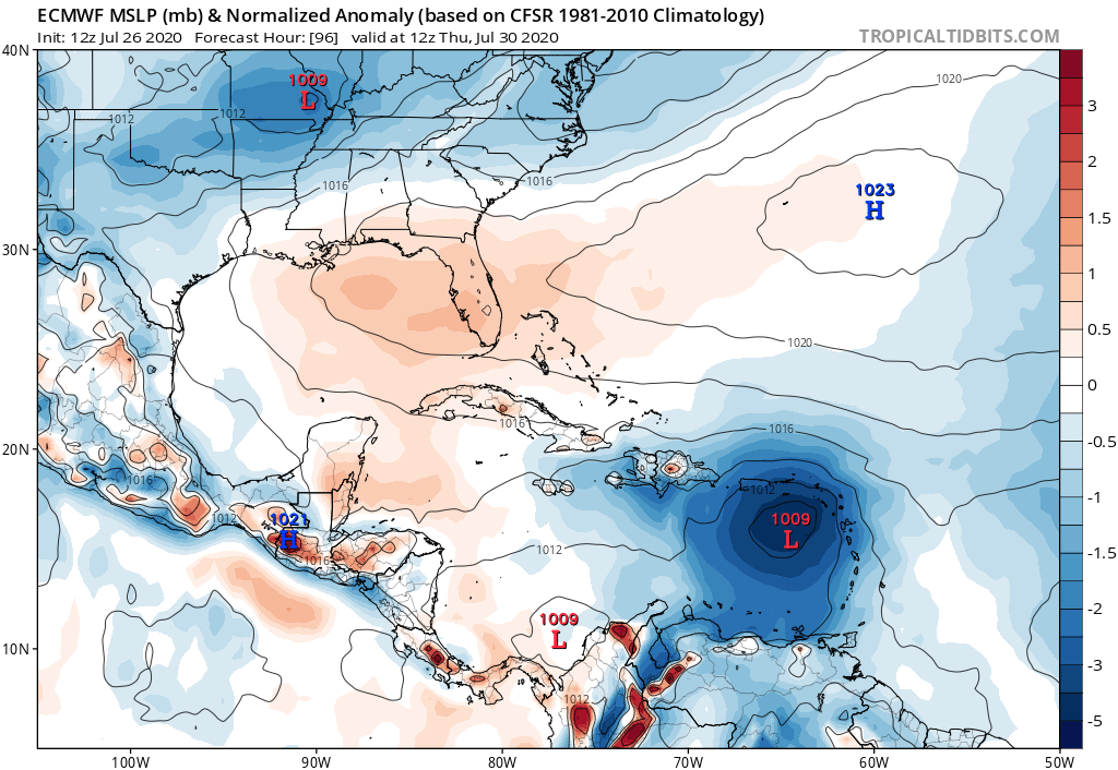
gatorcane wrote:HurricaneFrances04 wrote:Euro looks like it's still to the SW of the GFS. Seems like a significant difference at 72 hours out.
Euro is MUCH weaker too than the GFS. Looks like we have three runs in a row of the Euro showing only weak development into the islands.
https://i.postimg.cc/Kzdfmbbc/ecmwf-mslpa-Norm-watl-5.png
...and comes in south of the GA, too; although it could still be headed for the Shredder. With that high to the north though, I don't see a recurve coming from that image.
0 likes
-
AxaltaRacing24
- Category 5
- Posts: 1774
- Age: 25
- Joined: Wed Jul 27, 2016 11:14 am
- Location: Jupiter, FL
Re: ATL: INVEST 92L - Models
I hope nobody starts cancelling this season if the models don't show a hurricane by tonight.
Remember Harvey falling apart in LATE August in 2017?
Remember Harvey falling apart in LATE August in 2017?
8 likes
-
Shell Mound
- Category 5
- Posts: 2432
- Age: 33
- Joined: Thu Sep 07, 2017 3:39 pm
- Location: St. Petersburg, FL → Scandinavia
Re: ATL: INVEST 92L - Models
Side note: regardless of 92L’s fate, the 12Z ECMWF shows an extremely prolific African wave train in place by the last day of July.
11 likes
CVW / MiamiensisWx / Shell Mound
The posts in this forum are NOT official forecasts and should not be used as such. They are just the opinion of the poster and may or may not be backed by sound meteorological data. They are NOT endorsed by any professional institution or STORM2K. For official information, please refer to products from the NHC and NWS.
-
ConvergenceZone
.gif)
- Category 5
- Posts: 5241
- Joined: Fri Jul 29, 2005 1:40 am
- Location: Northern California
Re: ATL: INVEST 92L - Models
AxaltaRacing24 wrote:I hope nobody starts cancelling this season if the models don't show a hurricane by tonight.
Remember Harvey falling apart in LATE August in 2017?
Might cancel the rest of July, but definitely not the season.........
2 likes
-
TheProfessor

- Professional-Met

- Posts: 3506
- Age: 29
- Joined: Tue Dec 03, 2013 10:56 am
- Location: Wichita, Kansas
Re: ATL: INVEST 92L - Models
SFLcane wrote:TheProfessor wrote:As always timing is the key. The first thing we need to figure out is where the center forms, until that happens just about anything is on the table. Second we need to see how quickly the trough in Canada is able to erode the ridge. This determines how far west the storm gets initially. The third thing to watch is where exactly the storm is at when that cutoff low occurs. If the storm is already on its way out then there's not much worry for the mainland U.S, however if the storm is a bit delayed(like on the 6z GFS Parallel) then the cutoff low could actually increase the chance of a U.S landfall. The reason is because on both GFS models it sort of works to amplify the ridge and if the storm gets trapped under the ridge then a U.S landfall becomes extremely likely.
There's a lot that needs to be worked out still, if 92L's southerly energy is the one that forms and it take a more southerly track through the Caribbean, we could see some weird things track wise if it isn't quite able to feel the weakness to the north to escape but enough of it to move north in the short term before it gets shunted to the west. Something like Matthew with a more westward bend could happen if it doesn't take the first escape route.
Hi Theprofessor, Matthew 2016?
Yes, if the storm finds itself in the Caribbean I could see it share a similar track initially, but if the GFS is right about the ridge amplifying back, then it would take a more of bend west than Matthew did. It all depends on where the storm goes in the medium range.
0 likes
An alumnus of The Ohio State University.
Your local National Weather Service office is your best source for weather information.
Your local National Weather Service office is your best source for weather information.
-
toad strangler

- S2K Supporter
- Posts: 4546
- Joined: Sun Jul 28, 2013 3:09 pm
- Location: Earth
- Contact:
Re: ATL: INVEST 92L - Models
12z Euro with a weak wave near Jamaica @144
0 likes
My Weather Station
https://www.wunderground.com/dashboard/pws/KFLPORTS603
https://www.wunderground.com/dashboard/pws/KFLPORTS603
-
gatorcane
- S2K Supporter
- Posts: 23708
- Age: 48
- Joined: Sun Mar 13, 2005 3:54 pm
- Location: Boca Raton, FL
Re: ATL: INVEST 92L - Models
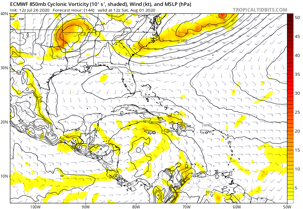
toad strangler wrote:12z Euro with a weak wave near Jamaica @144
1 likes


Re: ATL: INVEST 92L - Models
gatorcane wrote:toad strangler wrote:12z Euro with a weak wave near Jamaica @144
https://i.postimg.cc/yNx2d7M0/ecmwf-uv850-vort-watl-7.png
That's not a warm and fuzzy look for those in Cuba, Florida, Yucatan, or the GOM. All this model run tells me is that nearer term conditions might appear to be less conducive for development and for a T.S. to form and recurve east of the Lesser Antilles. That would imply potential downstream threat. I'll say this however, I would tend to side with NHC more then any one model regarding near term (1-4 days) development. The Euro 72hr.- 96hr seems plausible. Not sure i'd put much stock beyond that though.
6 likes
Andy D
(For official information, please refer to the NHC and NWS products.)
(For official information, please refer to the NHC and NWS products.)
-
Hypercane_Kyle

- Category 5
- Posts: 3465
- Joined: Sat Mar 07, 2015 7:58 pm
- Location: Cape Canaveral, FL
Re: ATL: INVEST 92L - Models
Another case of ECMWF vs. rest of the models...
0 likes
My posts are my own personal opinion, defer to the National Hurricane Center (NHC) and other NOAA products for decision making during hurricane season.
-
Stormcenter
- S2K Supporter
- Posts: 6689
- Joined: Wed Sep 03, 2003 11:27 am
- Location: Houston, TX
Re: ATL: INVEST 92L - Models
Excellent point.
MississippiWx wrote:Just curious, but did any of you pay attention to basically every model missing out on a HURRICANE forming in the Gulf of Mexico this week-even as little as 1-2 days out?
So yeah...I’m sure these 5-6 day model outputs are solid. Until 92L can decide which vort is the dominant one, long range model output is useless.
2 likes
-
HurricaneFrances04
- Category 2
- Posts: 597
- Joined: Mon Jun 25, 2012 8:09 am
- Location: Fort Lauderdale, Florida
Re: ATL: INVEST 92L - Models
I don't see any Euro ensemble members that have this in the western Caribbean. It's either smashing into Hispaniola or NW through the Bahamas.
Edit:
Edit:
Last edited by HurricaneFrances04 on Sun Jul 26, 2020 2:45 pm, edited 1 time in total.
0 likes
-
HurricaneFrances04
- Category 2
- Posts: 597
- Joined: Mon Jun 25, 2012 8:09 am
- Location: Fort Lauderdale, Florida

-
CrazyC83
- Professional-Met
- Posts: 34315
- Joined: Tue Mar 07, 2006 11:57 pm
- Location: Deep South, for the first time!
Re: ATL: INVEST 92L - Models
0 likes
-
CyclonicFury

- Category 5
- Posts: 2032
- Age: 27
- Joined: Sun Jul 02, 2017 12:32 pm
- Location: NC
- Contact:
Re: ATL: INVEST 92L - Models
I don't think the ECMWF solution is unreasonable. It's still early in the season and conditions in the eastern Caribbean typically are still hostile this early, especially for a weak system. It'll likely get named, but to become a significant hurricane it will likely need to organize some before it gets to the Lesser Antilles.
4 likes
NCSU B.S. in Meteorology Class of 2021. Tropical weather blogger at http://www.cyclonicfury.com. My forecasts and thoughts are NOT official, for official forecasts please consult the National Hurricane Center.
-
ConvergenceZone
- Category 5
- Posts: 5241
- Joined: Fri Jul 29, 2005 1:40 am
- Location: Northern California
Re: ATL: INVEST 92L - Models
Really glad that the Trend is out to sea.....I wouldn't pay as much attention to it if only 1 or 2 models were taking it out to sea, but when they all start trending it in that direction, they are obviously onto something.....
1 likes
Who is online
Users browsing this forum: No registered users and 33 guests