ATL: ISAIAS - Post-Tropical - Discussion

Moderator: S2k Moderators

Message
Author
User avatar
cycloneye
Admin
Admin
Posts: 145282
Age: 68
Joined: Thu Oct 10, 2002 10:54 am
Location: San Juan, Puerto Rico

Re: ATL: INVEST 92L - Discussion

#161 Postby cycloneye » Sun Jul 26, 2020 2:17 pm

wxman57 wrote:I don't expect it to do much for the next couple of days due to its very fast west movement. Should be a TD by Wednesday and a TS as it enters the NE Caribbean Wednesday night. Near the Bahamas next Fri/Sat, quite possibly as a hurricane. Beyond then, who knows? Models indicate a trof off the East U.S. Coast next weekend. If it's stronger, it could be steered north, missing the US to the east. For now, I'd put my money on a Carolinas hit early next week. Way too far out and very low confidence on that forecast, though. I think if it's slower to develop and is weaker, then a more westerly track, which could take it to the NW Caribbean in 7-8 days.


I really hope it evades the NE Caribbean because the islands have gone thru a lot lately with Irma and Maria and of course dealing now with covid-19.There are still parts of some of the islands that not recovered yet from the hurricanes like here in PR where believe it or not there are over 30,000 homes with blue tarps.
5 likes   
Visit the Caribbean-Central America Weather Thread where you can find at first post web cams,radars
and observations from Caribbean basin members Click Here

Mouton
S2K Supporter
S2K Supporter
Posts: 221
Age: 79
Joined: Sat Jul 30, 2011 8:13 am
Location: Amelia Island Florida

Re: ATL: INVEST 92L - Discussion

#162 Postby Mouton » Sun Jul 26, 2020 2:26 pm

Bastardi in his update last night suggested this will become a storm. He added looks to be a split in the trough coming which could provide a path into the SE states. He was not too specific but it looked like he was pointing to the NE Florida to SC area for a potential impact. Today's PM plots off Tropical Tidbits seem to show a turn straight north before 75W. IMO, this far out, no need to get overly concerned especially with models veering more from a US over past 24 hours.
4 likes   

Aric Dunn
Category 5
Category 5
Posts: 21238
Age: 42
Joined: Sun Sep 19, 2004 9:58 pm
Location: Ready for the Chase.
Contact:

Re: ATL: INVEST 92L - Discussion

#163 Postby Aric Dunn » Sun Jul 26, 2020 3:09 pm

I must say that is one of the largest Circulations I have ever seen lol

if it ever did become a hurricane .. you better bet it would create its own environemnt

Image
25 likes   
Note: If I make a post that is brief. Please refer back to previous posts for the analysis or reasoning. I do not re-write/qoute what my initial post said each time.
If there is nothing before... then just ask :)

Space & Atmospheric Physicist, Embry-Riddle Aeronautical University,
I believe the sky is falling...

User avatar
ScottNAtlanta
Category 5
Category 5
Posts: 2367
Joined: Sat May 25, 2013 3:11 pm
Location: Atlanta, GA

Re: ATL: INVEST 92L - Discussion

#164 Postby ScottNAtlanta » Sun Jul 26, 2020 3:12 pm

Aric Dunn wrote:I must say that is one of the largest Circulations I have ever seen lol

if it ever did become a hurricane .. you better bet it would create its own environemnt

https://i.ibb.co/bXRXCn5/26038474.gif

It takes up 3/4 of the Atlantic between Africa and the Islands
9 likes   
The posts in this forum are NOT official forecast and should not be used as such. They are just the opinion of the poster and may or may not be backed by sound meteorological data. They are NOT endorsed by any professional institution or storm2k.org. For official information, please refer to the NHC and NWS products.

shah83
Category 1
Category 1
Posts: 302
Joined: Sun Jul 31, 2016 4:55 pm

Re: ATL: INVEST 92L - Discussion

#165 Postby shah83 » Sun Jul 26, 2020 3:15 pm

HurricaneAndre2008 wrote:They are writing off 92L on wunderground. Lol


what's the link to the new chat? I only see the bland weather news now there and no comments.
2 likes   

TheStormExpert

Re: ATL: INVEST 92L - Discussion

#166 Postby TheStormExpert » Sun Jul 26, 2020 3:18 pm

Aric Dunn wrote:I must say that is one of the largest Circulations I have ever seen lol

if it ever did become a hurricane .. you better bet it would create its own environemnt

https://i.ibb.co/bXRXCn5/26038474.gif

Does its large circulation make it more susceptible to dry air and SAL intrusions?
0 likes   

Aric Dunn
Category 5
Category 5
Posts: 21238
Age: 42
Joined: Sun Sep 19, 2004 9:58 pm
Location: Ready for the Chase.
Contact:

Re: ATL: INVEST 92L - Discussion

#167 Postby Aric Dunn » Sun Jul 26, 2020 3:28 pm

TheStormExpert wrote:
Aric Dunn wrote:I must say that is one of the largest Circulations I have ever seen lol

if it ever did become a hurricane .. you better bet it would create its own environemnt

https://i.ibb.co/bXRXCn5/26038474.gif

Does its large circulation make it more susceptible to dry air and SAL intrusions?


It has plenty of moisture options. so I would imagine dry air would not last long around it..
1 likes   
Note: If I make a post that is brief. Please refer back to previous posts for the analysis or reasoning. I do not re-write/qoute what my initial post said each time.
If there is nothing before... then just ask :)

Space & Atmospheric Physicist, Embry-Riddle Aeronautical University,
I believe the sky is falling...

Nuno
Category 2
Category 2
Posts: 597
Joined: Fri Aug 30, 2019 8:35 am
Location: Coral Gables, FL

Re: ATL: INVEST 92L - Discussion

#168 Postby Nuno » Sun Jul 26, 2020 3:36 pm

It's large size is going to probably hinder it consolidating in the near short term, but once it gets going, watch out.
9 likes   
Andrew (1992), Irene (1999), Frances (2004), Katrina (2005), Wilma (2005), Fay (2008), Irma (2017), Eta (2020), Ian (2022)

Michele B
S2K Supporter
S2K Supporter
Posts: 1114
Joined: Thu Aug 25, 2016 8:08 am
Location: SWFL

Re: ATL: INVEST 92L - Discussion

#169 Postby Michele B » Sun Jul 26, 2020 3:44 pm

ScottNAtlanta wrote:
Aric Dunn wrote:I must say that is one of the largest Circulations I have ever seen lol

if it ever did become a hurricane .. you better bet it would create its own environemnt

https://i.ibb.co/bXRXCn5/26038474.gif

It takes up 3/4 of the Atlantic between Africa and the Islands


Looks very healthy for being only an "invest."
3 likes   
Cleo - 1964, Betsy - 1965, David - 1979, Andrew - 1992, Charlie (Francis, Ivan, Jeanne) - 2004, Irma - 2017, Ian - 2022

User avatar
tiger_deF
Category 1
Category 1
Posts: 468
Age: 24
Joined: Tue Sep 27, 2016 11:47 am

Re: ATL: INVEST 92L - Discussion

#170 Postby tiger_deF » Sun Jul 26, 2020 3:53 pm

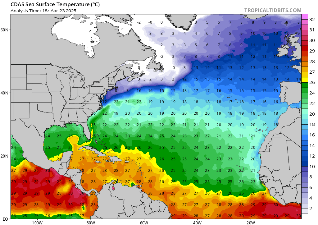
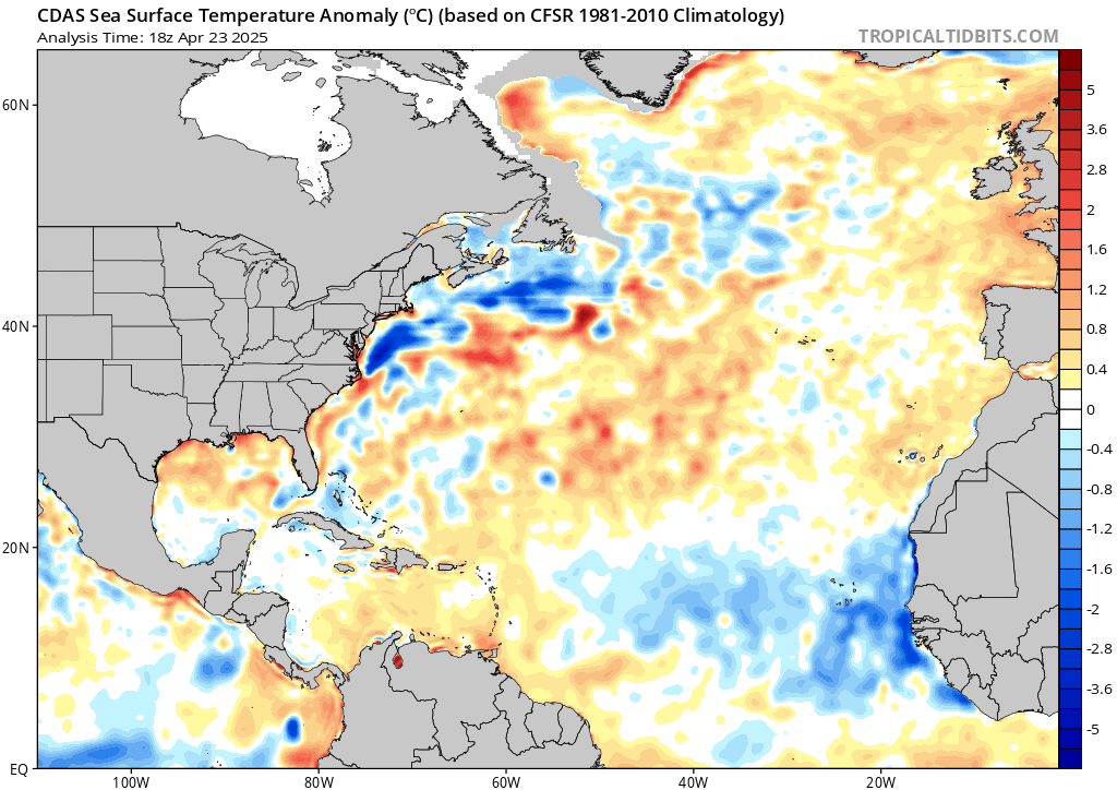
In the longer term, 92L is going to be moving through some pretty steamy SST's. While Hanna did a number on the northern gulf, pretty much all of the water in the short term ahead of 92L is running around 1 degree Celsius above normal. If this ever does become an east coast threat the waters are absolutely primed, especially a little further north with SST anomalies running 2-3+ degrees above normal. The 26 degree isotherm is even further north than long Island, so any system tracking nearby would get some serious fuel. Dry air and forward speed, not ocean temperatures, will (hopefully) be the main dampeners of the system.
Image

Image
2 likes   

User avatar
HurricaneMaster_PR
Category 2
Category 2
Posts: 795
Joined: Tue Jul 22, 2003 6:23 pm
Location: San Juan, Puerto Rico

Re: ATL: INVEST 92L - Discussion

#171 Postby HurricaneMaster_PR » Sun Jul 26, 2020 3:56 pm

This afternoon there’s been an increase in intense thunderstorms near the designated center, which is interesting since we are not in the diurnal maximum yet. Take a look at the last frames:
https://www.tropicaltidbits.com/sat/sat ... product=ir
1 likes   

SconnieCane
Category 4
Category 4
Posts: 998
Joined: Thu Aug 02, 2018 5:29 pm
Location: Madison, WI

Re: ATL: INVEST 92L - Discussion

#172 Postby SconnieCane » Sun Jul 26, 2020 4:01 pm

Aric Dunn wrote:I must say that is one of the largest Circulations I have ever seen lol

if it ever did become a hurricane .. you better bet it would create its own environemnt

https://i.ibb.co/bXRXCn5/26038474.gif


The anti-Gonzalo. :lol:
7 likes   

User avatar
Nimbus
Category 5
Category 5
Posts: 5300
Joined: Mon Jul 19, 2004 10:54 am

Re: ATL: INVEST 92L - Discussion

#173 Postby Nimbus » Sun Jul 26, 2020 4:28 pm

Large circulation means it has a shallow pressure gradient.
Convection firing closer to the ITCZ tonight might be the latitude for an eventual low level center.
Models are pretty much a Rorschach Test, and I never did very well on those till somebody points.
The current recurve trend in the models will swing left if the system stays weak and south.

That would be great if the first Cape Verde hurricane recurved and stirred the coffee leaving a peak season kink in the Jet stream. The current mid Atlantic ridging is bad news.
4 likes   

supercane4867
Category 5
Category 5
Posts: 4966
Joined: Wed Nov 14, 2012 10:43 am

Re: ATL: INVEST 92L - Discussion

#174 Postby supercane4867 » Sun Jul 26, 2020 4:48 pm

This invest is HUGE by Atlantic standards. Looks like something straight out of equatorial WPAC.
13 likes   

User avatar
tiger_deF
Category 1
Category 1
Posts: 468
Age: 24
Joined: Tue Sep 27, 2016 11:47 am

Re: ATL: INVEST 92L - Discussion

#175 Postby tiger_deF » Sun Jul 26, 2020 4:50 pm

supercane4867 wrote: Looks like something straight out of equatorial WPAC.


That appears to be the theme of the season..
6 likes   

supercane4867
Category 5
Category 5
Posts: 4966
Joined: Wed Nov 14, 2012 10:43 am

Re: ATL: INVEST 92L - Discussion

#176 Postby supercane4867 » Sun Jul 26, 2020 4:51 pm

tiger_deF wrote:
supercane4867 wrote: Looks like something straight out of equatorial WPAC.


That appears to be the theme of the season..

It's almost as if the Atlantic and WPAC swapped basins. Record activity in the Atlantic came with the record inactivity of the WPAC.
13 likes   

User avatar
La Breeze
Tropical Storm
Tropical Storm
Posts: 168
Joined: Sun Jul 26, 2015 3:21 am
Location: Vermilion Parish, LA

Re: ATL: INVEST 92L - Discussion

#177 Postby La Breeze » Sun Jul 26, 2020 5:38 pm

Aric Dunn wrote:I must say that is one of the largest Circulations I have ever seen lol

if it ever did become a hurricane .. you better bet it would create its own environemnt

https://i.ibb.co/bXRXCn5/26038474.gif

I totally agree - that's a huge circulation. Gut feeling is that we will have to watch this one closely.
0 likes   
Not a professional forecast by any means.
Audrey'57, Hilda'64, Betsy '65, Edith'71, Carmen'74, Danny'85, Juan'85, Andrew'92, Iniki'92 (while on vacation in Kauai), Lili'02, Rita'05, Humberto'07, Gustav'08, Ike'08, Isaac'12, Monsoonal Depression'16, Harvey'17, Barry'19, Laura'20, Delta'20, Ida'21.

User avatar
CyclonicFury
Category 5
Category 5
Posts: 2025
Age: 26
Joined: Sun Jul 02, 2017 12:32 pm
Location: NC
Contact:

Re: ATL: INVEST 92L - Discussion

#178 Postby CyclonicFury » Sun Jul 26, 2020 5:42 pm

Some potential analogs for 92L are Emily (2011) and Bertha (2014). Very similar time of year and potential track.
4 likes   
NCSU B.S. in Meteorology Class of 2021. Tropical weather blogger at http://www.cyclonicfury.com. My forecasts and thoughts are NOT official, for official forecasts please consult the National Hurricane Center.

User avatar
ScottNAtlanta
Category 5
Category 5
Posts: 2367
Joined: Sat May 25, 2013 3:11 pm
Location: Atlanta, GA

Re: ATL: INVEST 92L - Discussion

#179 Postby ScottNAtlanta » Sun Jul 26, 2020 5:52 pm

I keep having to remember...its JULY, not SEPTEMBER!
It's not normal to be expecting Cape Verde development

:sick: :sick: :sick:
7 likes   
The posts in this forum are NOT official forecast and should not be used as such. They are just the opinion of the poster and may or may not be backed by sound meteorological data. They are NOT endorsed by any professional institution or storm2k.org. For official information, please refer to the NHC and NWS products.

User avatar
aspen
Category 5
Category 5
Posts: 8818
Joined: Sat Oct 12, 2019 7:10 pm
Location: Connecticut, USA

Re: ATL: INVEST 92L - Discussion

#180 Postby aspen » Sun Jul 26, 2020 6:10 pm

CyclonicFury wrote:Some potential analogs for 92L are Emily (2011) and Bertha (2014). Very similar time of year and potential track.

We do not mention that last one here! That ugly mess can just be forgotten and never heard of again.
6 likes   
Irene '11 Sandy '12 Hermine '16 5/15/2018 Derecho Fay '20 Isaias '20 Elsa '21 Henri '21 Ida '21

I am only a meteorology enthusiast who knows a decent amount about tropical cyclones. Look to the professional mets, the NHC, or your local weather office for the best information.


Return to “2020”

Who is online

Users browsing this forum: No registered users and 7 guests