Hurricaneman wrote:Is it me or did the GFS shift farther east, either it will be right and be a possible fish or the GFS will bust hard on track
it did.
Moderator: S2k Moderators

Hurricaneman wrote:Is it me or did the GFS shift farther east, either it will be right and be a possible fish or the GFS will bust hard on track
Hurricaneman wrote:Is it me or did the GFS shift farther east, either it will be right and be a possible fish or the GFS will bust hard on track
Hurricaneman wrote:Is it me or did the GFS shift farther east, either it will be right and be a possible fish or the GFS will bust hard on track
caneseddy wrote:Hurricaneman wrote:Is it me or did the GFS shift farther east, either it will be right and be a possible fish or the GFS will bust hard on track
Yes it has shifted east all day today. While it may be right, based on its track record so far this season, I’m hesitant to be confident in its solution at this time
Kazmit wrote:
Only thing I can think of when I see this is a particular storm from a few years ago.


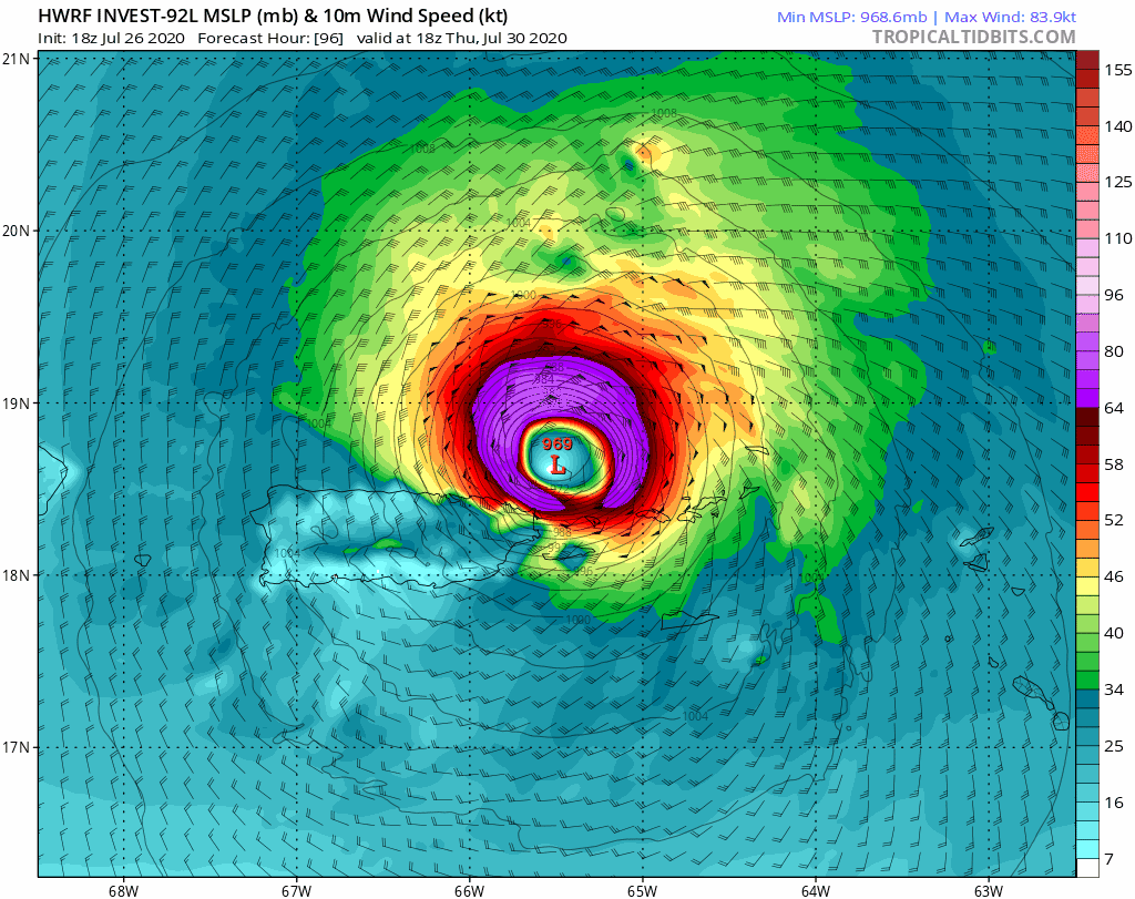
SouthFLTropics wrote:00z HWRF brings a low end Cat 1 North of Cuba and East of Abaco
Shell Mound wrote:SouthFLTropics wrote:00z HWRF brings a low end Cat 1 North of Cuba and East of Abaco
You must mean Andros. By 126 hours the system is approaching the southernmost tip of Andros in the SW Bahamas and is moving WNW.


CM2 wrote:Well the GFS-Para has quite a solution to the dry air problem... rapidly intensify right as it gets near the coast. Also what is the GFS-Para, just the old GFS like the FV3 or a new "beta" GFS?
https://imgur.com/iEfdlgh
USTropics wrote:It's basically testing new updates for the GFS. It runs as secondary to the current GFS operational runs, but will eventually replace the operational GFS.

Hurricaneman wrote:The GFS seems to be way east of all other models by a large margin, could it be dropping the ridge too quickly
Hurricaneman wrote:The GFS seems to be way east of all other models by a large margin, could it be dropping the ridge too quickly
CM2 wrote:You say this but let me show you the lastest GFS-Para run. Surely is quite the interesting situation they brought to the table now. A slow moving storm to the Carolina's/East Coast with a sudden ridge pushing it west slowly.
Users browsing this forum: No registered users and 12 guests


