Aric Dunn wrote:90 hours after crossing Hispaniola and eastern cuba
https://i.ibb.co/tMQr7V9/Capture.png
Is 18z a north shift? Can you post the next position?
Moderator: S2k Moderators


Aric Dunn wrote:90 hours after crossing Hispaniola and eastern cuba
https://i.ibb.co/tMQr7V9/Capture.png
Blown Away wrote:Aric Dunn wrote:90 hours after crossing Hispaniola and eastern cuba
https://i.ibb.co/tMQr7V9/Capture.png
Is 18z a north shift? Can you post the next position?

.Aric Dunn wrote:90 hours after crossing Hispaniola and eastern cuba
https://i.ibb.co/tMQr7V9/Capture.png

STRiZZY wrote:The big question is does 92l try to consolidate the southern lobe or northern lobe. Looks like the southern side is winning the fight right now. All of the models right now have been struggling with this and develop the northern lobe.
https://www.weathernerds.org/satellite/sessions/GOES16_1km_ir_202007280025_3.75_19.00_-64.00_-35.25_vis1_ltng16_hgwy_warn_weathernerds.png
Aric Dunn wrote:90 hours after crossing Hispaniola and eastern cuba
https://i.ibb.co/tMQr7V9/Capture.png
Hammy wrote:STRiZZY wrote:The big question is does 92l try to consolidate the southern lobe or northern lobe. Looks like the southern side is winning the fight right now. All of the models right now have been struggling with this and develop the northern lobe.
https://www.weathernerds.org/satellite/sessions/GOES16_1km_ir_202007280025_3.75_19.00_-64.00_-35.25_vis1_ltng16_hgwy_warn_weathernerds.png
Progression reminds me of Gabrielle in 2013 (which shows just how completely off things were--the atmosphere essentially stayed in July and jumped straight to November later on) being large and seemingly two competing segments of the wave. Hermine in 2016 also did something similar.Aric Dunn wrote:90 hours after crossing Hispaniola and eastern cuba
https://i.ibb.co/tMQr7V9/Capture.png
Is it actually getting sliced in half by the Greater Antilles due to the size?

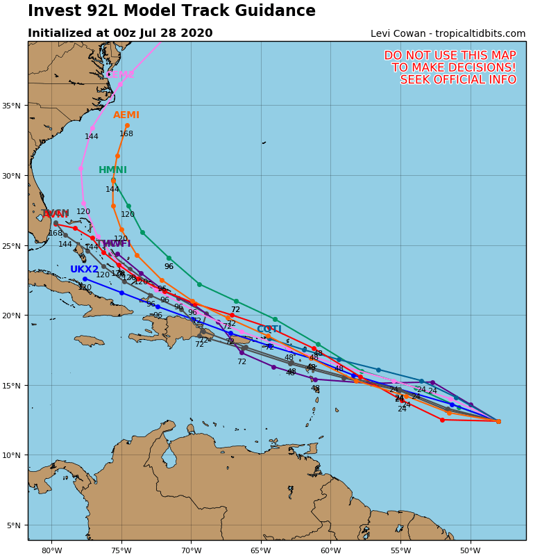
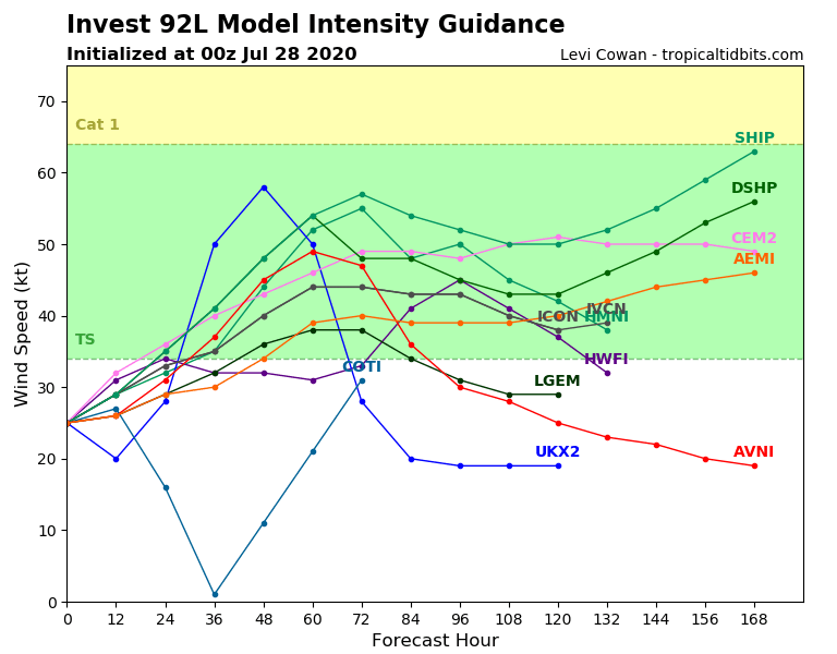
gatorcane wrote:00Z guidance, a bit of an uptick on intensity. TVCN (model consensus) into the Bahamas:
https://i.postimg.cc/YScmxSqf/92-L-tracks-00z.png
https://i.postimg.cc/QCMBM90s/92-L-intensity-00z.png

CM2 wrote:gatorcane wrote:00Z guidance, a bit of an uptick on intensity. TVCN (model consensus) into the Bahamas:
https://i.postimg.cc/YScmxSqf/92-L-tracks-00z.png
https://i.postimg.cc/QCMBM90s/92-L-intensity-00z.png
With planes going into the storm tomorrow, the data for the storm recon should really improve model runs. For now the runs are gonna be garbage.
Ubuntwo wrote:0z SHIPS out and it's an uptick from the bearish 18z run. Tropical storm in 24 hours, hurricane in a week.

STRiZZY wrote:Euro 18z ensembles more bullish. Few of the members are hurricanes just missing Florida.
sma10 wrote:STRiZZY wrote:Euro 18z ensembles more bullish. Few of the members are hurricanes just missing Florida.
Just curious Strizzy - what path do those hurricanes take? Presumably avoid Hispaniola?
Users browsing this forum: No registered users and 26 guests


