ATL: ISAIAS - Models
Moderator: S2k Moderators

-
HurricaneFrances04
- Category 2

- Posts: 597
- Joined: Mon Jun 25, 2012 8:09 am
- Location: Fort Lauderdale, Florida
Re: ATL: NINE - Models
Not even windshield wiping. Models have shown a NW track and the invest kept speeding west. If anything, it's finally capitulating to what the Euro showed days ago.
0 likes
-
Hypercane_Kyle

- Category 5

- Posts: 3465
- Joined: Sat Mar 07, 2015 7:58 pm
- Location: Cape Canaveral, FL
Re: ATL: NINE - Models
12z GFS consolidating faster, further north compared to previous runs.
0 likes
My posts are my own personal opinion, defer to the National Hurricane Center (NHC) and other NOAA products for decision making during hurricane season.
-
tolakram
- Admin

- Posts: 20170
- Age: 62
- Joined: Sun Aug 27, 2006 8:23 pm
- Location: Florence, KY (name is Mark)
Re: ATL: NINE - Models
DestinHurricane wrote:Otown_Wx wrote:Been years since last post, so hello everyone! From Orlando and see the first cone came out and shows it coming into Florida. Is this something we should worry about meaning a MH.
No, this won't become a major.
Even pro mets will qualify their statements some level of humility, regardless of how sure they are. Do not make, and everyone please do not take seriously deterministic statements like this. The question of should I be worried should always be answered the same way: You should be prepared already (as you should be every season), and then keep an eye on it. No model has done very good this year, even 5 days out. Last Tuesdays run of the Euro showed Hannah as a wave into the Texas coast.
There is no way to know at this time how strong the storm will be, or the exact path.
10 likes
M a r k
- - - - -
Join us in chat: Storm2K Chatroom Invite. Android and IOS apps also available.
The posts in this forum are NOT official forecasts and should not be used as such. Posts are NOT endorsed by any professional institution or STORM2K.org. For official information and forecasts, please refer to NHC and NWS products.
-
Blown Away

- S2K Supporter

- Posts: 10253
- Joined: Wed May 26, 2004 6:17 am
Re: ATL: NINE - Models
Hypercane_Kyle wrote:12z GFS consolidating faster, further north compared to previous runs.
Also moving faster which hopefully keeps intensity down, but may mean a farther W track.
0 likes
Hurricane Eye Experience: David 79, Irene 99, Frances 04, Jeanne 04, Wilma 05… Hurricane Brush Experience: Andrew 92, Erin 95, Floyd 99, Matthew 16, Irma 17, Ian 22, Nicole 22…
-
Shell Mound
- Category 5
- Posts: 2432
- Age: 33
- Joined: Thu Sep 07, 2017 3:39 pm
- Location: St. Petersburg, FL → Scandinavia
Re: ATL: NINE - Models
Hypercane_Kyle wrote:12z GFS consolidating faster, further north compared to previous runs.
The key is that the 12Z run shows greater organisation within the next day and a half vs. previous runs, thus breaking the earlier trend toward a weaker system. This could also mean the difference between a system that gets sheared apart by the TUTT vs. one that manages to “create its own environment” on account of its being more organised by the time it nears Puerto Rico and the USVI. Additionally, note that the latest run shows the southern vortex becoming dominant and then pirouetting northward as the old, northern vortex gets absorbed.
Edit: shear vectors look much more favourable by day three vs. earlier runs as the system enters the southeastern Bahamas.
0 likes
CVW / MiamiensisWx / Shell Mound
The posts in this forum are NOT official forecasts and should not be used as such. They are just the opinion of the poster and may or may not be backed by sound meteorological data. They are NOT endorsed by any professional institution or STORM2K. For official information, please refer to products from the NHC and NWS.
-
toad strangler

- S2K Supporter
- Posts: 4546
- Joined: Sun Jul 28, 2013 3:09 pm
- Location: Earth
- Contact:
Re: ATL: NINE - Models
A hair more defined at 102 hrs than 6z on the GFS
0 likes
My Weather Station
https://www.wunderground.com/dashboard/pws/KFLPORTS603
https://www.wunderground.com/dashboard/pws/KFLPORTS603

Re: ATL: NINE - Models
12z GFS is the strongest GFS run in a while, but it still tries to kill off PTC-9 in the Bahamas by day 4/5.
0 likes
Irene '11 Sandy '12 Hermine '16 5/15/2018 Derecho Fay '20 Isaias '20 Elsa '21 Henri '21 Ida '21
I am only a meteorology enthusiast who knows a decent amount about tropical cyclones. Look to the professional mets, the NHC, or your local weather office for the best information.
I am only a meteorology enthusiast who knows a decent amount about tropical cyclones. Look to the professional mets, the NHC, or your local weather office for the best information.
-
Blown Away
- S2K Supporter
- Posts: 10253
- Joined: Wed May 26, 2004 6:17 am
Re: ATL: NINE - Models
12z GFS slightly faster and comes closer to SFL, but continues to show at best a TD/Minimal TS.
0 likes
Hurricane Eye Experience: David 79, Irene 99, Frances 04, Jeanne 04, Wilma 05… Hurricane Brush Experience: Andrew 92, Erin 95, Floyd 99, Matthew 16, Irma 17, Ian 22, Nicole 22…
-
toad strangler
- S2K Supporter
- Posts: 4546
- Joined: Sun Jul 28, 2013 3:09 pm
- Location: Earth
- Contact:
Re: ATL: NINE - Models
CRAWLING on 12z GFS
0 likes
My Weather Station
https://www.wunderground.com/dashboard/pws/KFLPORTS603
https://www.wunderground.com/dashboard/pws/KFLPORTS603


Re: ATL: NINE - Models
NEW TROPICAL CYCLONE FORECAST TO DEVELOP AFTER 24 HOURS
FORECAST POSITION AT T+ 24 : 15.3N 61.1W
LEAD CENTRAL MAXIMUM WIND
VERIFYING TIME TIME POSITION PRESSURE (MB) SPEED (KNOTS)
-------------- ---- -------- ------------- -------------
1200UTC 29.07.2020 24 15.3N 61.1W 1006 36
0000UTC 30.07.2020 36 16.7N 63.7W 1004 40
1200UTC 30.07.2020 48 18.0N 66.5W 1003 46
0000UTC 31.07.2020 60 18.9N 68.6W 1002 46
1200UTC 31.07.2020 72 20.0N 70.6W 1002 45
0000UTC 01.08.2020 84 20.8N 73.6W 1002 44
1200UTC 01.08.2020 96 21.9N 75.5W 1003 40
0000UTC 02.08.2020 108 23.3N 76.8W 1001 45
1200UTC 02.08.2020 120 24.9N 77.7W 996 47
0000UTC 03.08.2020 132 26.5N 78.1W 990 51
1200UTC 03.08.2020 144 28.1N 78.5W 985 53
0 likes
-
Shell Mound
- Category 5
- Posts: 2432
- Age: 33
- Joined: Thu Sep 07, 2017 3:39 pm
- Location: St. Petersburg, FL → Scandinavia
Re: ATL: NINE - Models
Blown Away wrote:12z GFS slightly faster and comes closer to SFL, but continues to show at best a TD/Minimal TS.
Interestingly enough, the circulation remains rather symmetrical for nearly four days—seemingly sufficient to “split the (weak) TUTT”:

Last edited by Shell Mound on Tue Jul 28, 2020 11:06 am, edited 1 time in total.
0 likes
CVW / MiamiensisWx / Shell Mound
The posts in this forum are NOT official forecasts and should not be used as such. They are just the opinion of the poster and may or may not be backed by sound meteorological data. They are NOT endorsed by any professional institution or STORM2K. For official information, please refer to products from the NHC and NWS.
-
TheStormExpert
Re: ATL: NINE - Models
Hypercane_Kyle wrote:12z GFS consolidating faster, further north compared to previous runs.
I’ll believe the GFS when it starts gaining latitude or at least changes its heading.
0 likes

-
toad strangler
- S2K Supporter
- Posts: 4546
- Joined: Sun Jul 28, 2013 3:09 pm
- Location: Earth
- Contact:
Re: ATL: NINE - Models
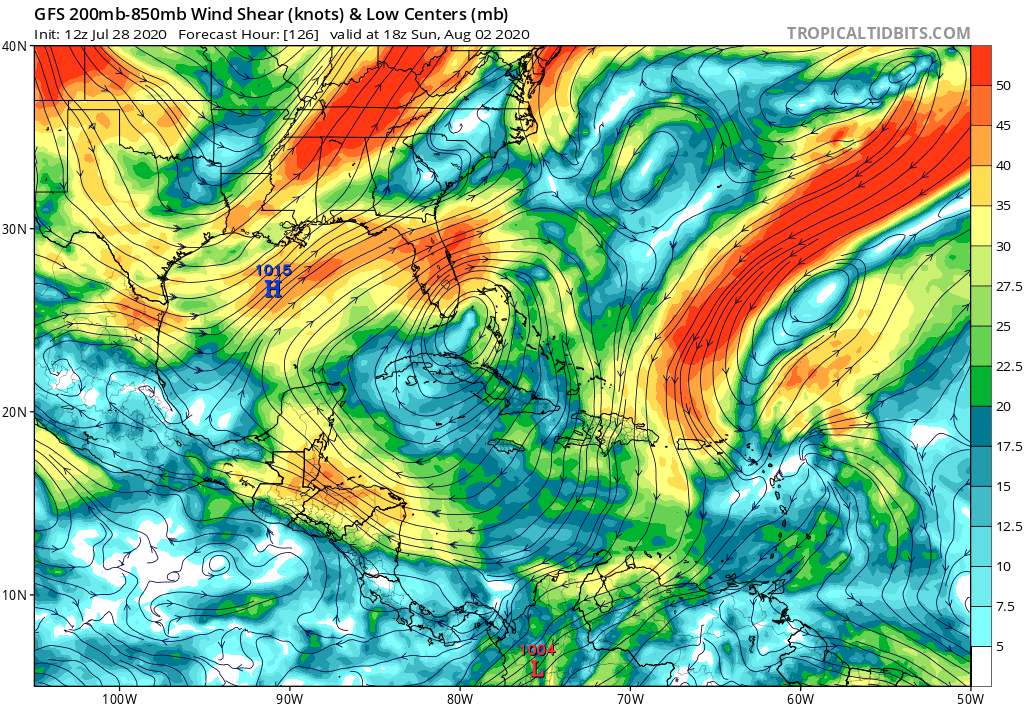
12z poofing this right of the SE FL Coast @126hrs
0 likes
My Weather Station
https://www.wunderground.com/dashboard/pws/KFLPORTS603
https://www.wunderground.com/dashboard/pws/KFLPORTS603
-
SFLcane

- S2K Supporter
- Posts: 10281
- Age: 48
- Joined: Sat Jun 05, 2010 1:44 pm
- Location: Lake Worth Florida
Re: ATL: NINE - Models
Even a TS in the Bahamas is playing with fire as those waters are extremely warm.
2 likes
-
gatorcane

- S2K Supporter
- Posts: 23708
- Age: 48
- Joined: Sun Mar 13, 2005 3:54 pm
- Location: Boca Raton, FL
Re: ATL: NINE - Models
toad strangler wrote:12z poofing this right of the SE FL Coast @126hrs
Yet the model shows a very favorable upper-level wind pattern that sets up as it approaches SE Florida. Hot water, slow moving, system. Hmmm...
Last edited by gatorcane on Tue Jul 28, 2020 11:11 am, edited 1 time in total.
5 likes
-
Shell Mound
- Category 5
- Posts: 2432
- Age: 33
- Joined: Thu Sep 07, 2017 3:39 pm
- Location: St. Petersburg, FL → Scandinavia
Re: ATL: NINE - Models
jconsor wrote:https://twitter.com/yconsor/status/1288144014923968519
Personally, I would blend (combine) the GFS-Parallel, HAFS-B, and HWRF/HMON for intensity and the ECMWF/EPS for the synoptic pattern, then put them all together.
Last edited by Shell Mound on Tue Jul 28, 2020 11:12 am, edited 1 time in total.
0 likes
CVW / MiamiensisWx / Shell Mound
The posts in this forum are NOT official forecasts and should not be used as such. They are just the opinion of the poster and may or may not be backed by sound meteorological data. They are NOT endorsed by any professional institution or STORM2K. For official information, please refer to products from the NHC and NWS.
Who is online
Users browsing this forum: No registered users and 64 guests