ATL: ISAIAS - Models
Moderator: S2k Moderators
-
toad strangler

- S2K Supporter

- Posts: 4546
- Joined: Sun Jul 28, 2013 3:09 pm
- Location: Earth
- Contact:
Re: ATL: NINE - Models
Fay 2.0 on 12z GFS
2 likes
My Weather Station
https://www.wunderground.com/dashboard/pws/KFLPORTS603
https://www.wunderground.com/dashboard/pws/KFLPORTS603
-
Hypercane_Kyle

- Category 5

- Posts: 3465
- Joined: Sat Mar 07, 2015 7:58 pm
- Location: Cape Canaveral, FL
Re: ATL: NINE - Models
Even as a slightly stronger system, 09L is unable to survive the sheer in the Bahamas. Needs to strengthen a lot more in order to do that.
0 likes
My posts are my own personal opinion, defer to the National Hurricane Center (NHC) and other NOAA products for decision making during hurricane season.
-
Blown Away

- S2K Supporter
- Posts: 10253
- Joined: Wed May 26, 2004 6:17 am
Re: ATL: NINE - Models

12z GFS...TS/TD as it nears SFL, then crawls for a few days over the peninsula = torrential rain...
3 likes
Hurricane Eye Experience: David 79, Irene 99, Frances 04, Jeanne 04, Wilma 05… Hurricane Brush Experience: Andrew 92, Erin 95, Floyd 99, Matthew 16, Irma 17, Ian 22, Nicole 22…
-
TheStormExpert
Re: ATL: NINE - Models
Hypercane_Kyle wrote:Even as a slightly stronger system, 09L is unable to survive the sheer in the Bahamas. Needs to strengthen a lot more in order to do that.
Yes there will be Southwesterly shear but an anti-cyclone is forecasted to stay almost on top of PTC-9 all the way to Florida. It’s the dry air that’s the biggest problem.
0 likes
-
TheStormExpert
Re: ATL: NINE - Models
gatorcane wrote:toad strangler wrote:12z poofing this right of the SE FL Coast @126hrs
Yet the model shows a very favorable upper-level wind pattern that sets up as it approaches SE Florida. Hot water, slow moving, system. Hmmm...
https://i.postimg.cc/L4vgxfHT/gfs-shear-watl-22.png
Dry air.

0 likes
-
gatorcane

- S2K Supporter
- Posts: 23708
- Age: 48
- Joined: Sun Mar 13, 2005 3:54 pm
- Location: Boca Raton, FL
Re: ATL: NINE - Models
CMC is a bit stronger and shifted west. Looks like it will landfall in SoFlo in the low 990mbs.
0 likes
-
ColdMiser123

- Professional-Met

- Posts: 905
- Age: 29
- Joined: Mon Sep 26, 2016 3:26 pm
- Location: Northeast US
Re: ATL: NINE - Models
UKMET significantly stronger:
NEW TROPICAL CYCLONE FORECAST TO DEVELOP AFTER 24 HOURS
FORECAST POSITION AT T+ 24 : 15.3N 61.1W
LEAD CENTRAL MAXIMUM WIND
VERIFYING TIME TIME POSITION PRESSURE (MB) SPEED (KNOTS)
-------------- ---- -------- ------------- -------------
1200UTC 29.07.2020 24 15.3N 61.1W 1006 36
0000UTC 30.07.2020 36 16.7N 63.7W 1004 40
1200UTC 30.07.2020 48 18.0N 66.5W 1003 46
0000UTC 31.07.2020 60 18.9N 68.6W 1002 46
1200UTC 31.07.2020 72 20.0N 70.6W 1002 45
0000UTC 01.08.2020 84 20.8N 73.6W 1002 44
1200UTC 01.08.2020 96 21.9N 75.5W 1003 40
0000UTC 02.08.2020 108 23.3N 76.8W 1001 45
1200UTC 02.08.2020 120 24.9N 77.7W 996 47
0000UTC 03.08.2020 132 26.5N 78.1W 990 51
1200UTC 03.08.2020 144 28.1N 78.5W 985 53
5 likes
B.S., M.S., Meteorology & Atmospheric Science
-
WeatherEmperor
- S2K Supporter
- Posts: 4806
- Age: 41
- Joined: Thu Sep 04, 2003 2:54 pm
- Location: South Florida
Re: ATL: NINE - Models
12z Canadian has a strong TS/Cat 1 about to make landfall in South Florida. Not liking this at all.....

Sent from my iPhone using Tapatalk
Sent from my iPhone using Tapatalk
0 likes
-
Evil Jeremy

- S2K Supporter
- Posts: 5463
- Age: 32
- Joined: Mon Apr 10, 2006 2:10 pm
- Location: Los Angeles, CA
Re: ATL: NINE - Models
WeatherEmperor wrote:12z Canadian has a strong TS/Cat 1 about to make landfall in South Florida. Not liking this at all.....
https://uploads.tapatalk-cdn.com/202007 ... 977387.jpg
Sent from my iPhone using Tapatalk
102 hours, too... The timeline for this keeps getting faster.
0 likes
Frances 04 / Jeanne 04 / Katrina 05 / Wilma 05 / Fay 08 / Debby 12 / Andrea 13 / Colin 16 / Hermine 16 / Matthew 16 / Irma 17
-
gatorcane
- S2K Supporter
- Posts: 23708
- Age: 48
- Joined: Sun Mar 13, 2005 3:54 pm
- Location: Boca Raton, FL
Re: ATL: NINE - Models
ColdMiser123 wrote:UKMET significantly stronger:
NEW TROPICAL CYCLONE FORECAST TO DEVELOP AFTER 24 HOURS
FORECAST POSITION AT T+ 24 : 15.3N 61.1W
LEAD CENTRAL MAXIMUM WIND
VERIFYING TIME TIME POSITION PRESSURE (MB) SPEED (KNOTS)
-------------- ---- -------- ------------- -------------
1200UTC 29.07.2020 24 15.3N 61.1W 1006 36
0000UTC 30.07.2020 36 16.7N 63.7W 1004 40
1200UTC 30.07.2020 48 18.0N 66.5W 1003 46
0000UTC 31.07.2020 60 18.9N 68.6W 1002 46
1200UTC 31.07.2020 72 20.0N 70.6W 1002 45
0000UTC 01.08.2020 84 20.8N 73.6W 1002 44
1200UTC 01.08.2020 96 21.9N 75.5W 1003 40
0000UTC 02.08.2020 108 23.3N 76.8W 1001 45
1200UTC 02.08.2020 120 24.9N 77.7W 996 47
0000UTC 03.08.2020 132 26.5N 78.1W 990 51
1200UTC 03.08.2020 144 28.1N 78.5W 985 53
And it is intensifying it as it moves through the Bahamas, ends up close to South Florida.
2 likes
-
Evil Jeremy
- S2K Supporter
- Posts: 5463
- Age: 32
- Joined: Mon Apr 10, 2006 2:10 pm
- Location: Los Angeles, CA
Re: ATL: NINE - Models
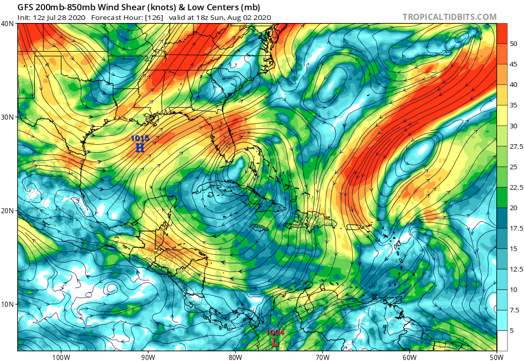
HWRF is running... Through 39 hours, it's further S and W at the same point than any of the previous 3 cycles. Looks like it's going to clip Puerto Rico.
1 likes
Frances 04 / Jeanne 04 / Katrina 05 / Wilma 05 / Fay 08 / Debby 12 / Andrea 13 / Colin 16 / Hermine 16 / Matthew 16 / Irma 17
-
jlauderdal
- S2K Supporter
- Posts: 7240
- Joined: Wed May 19, 2004 5:46 am
- Location: NE Fort Lauderdale
- Contact:
Re: RE: Re: ATL: NINE - Models
I dont like that track at all, anything coming in from that trajectory is dangerous, look for an intensity increase from nhcWeatherEmperor wrote:12z Canadian has a strong TS/Cat 1 about to make landfall in South Florida. Not liking this at all.....
Sent from my iPhone using Tapatalk
0 likes
-
AutoPenalti
- Category 5
- Posts: 4091
- Age: 29
- Joined: Mon Aug 17, 2015 4:16 pm
- Location: Ft. Lauderdale, Florida
Re: ATL: NINE - Models
Where’s the dry air the HWRF was forecasting within 72hrs?
0 likes
The posts in this forum are NOT official forecasts and should not be used as such. They are just the opinion of the poster and may or may not be backed by sound meteorological data. They are NOT endorsed by any professional institution or STORM2K. For official information, please refer to products from the NHC and NWS.
Model Runs Cheat Sheet:
GFS (5:30 AM/PM, 11:30 AM/PM)
HWRF, GFDL, UKMET, NAVGEM (6:30-8:00 AM/PM, 12:30-2:00 AM/PM)
ECMWF (1:45 AM/PM)
TCVN is a weighted averaged
-
Hypercane_Kyle
- Category 5
- Posts: 3465
- Joined: Sat Mar 07, 2015 7:58 pm
- Location: Cape Canaveral, FL
Re: ATL: NINE - Models
TheStormExpert wrote:gatorcane wrote:toad strangler wrote:12z poofing this right of the SE FL Coast @126hrs
Yet the model shows a very favorable upper-level wind pattern that sets up as it approaches SE Florida. Hot water, slow moving, system. Hmmm...
https://i.postimg.cc/L4vgxfHT/gfs-shear-watl-22.png
Dry air.
https://i.ibb.co/56sqB9k/gfs-mid-RH-watl-22.png
Appears to be so. I can tell you I've never seen dry air kill a storm completely near Florida in late-July.
0 likes
My posts are my own personal opinion, defer to the National Hurricane Center (NHC) and other NOAA products for decision making during hurricane season.
-
jlauderdal
- S2K Supporter
- Posts: 7240
- Joined: Wed May 19, 2004 5:46 am
- Location: NE Fort Lauderdale
- Contact:
Re: RE: Re: ATL: NINE - Models
Where are the OTS posts from 48 hrs ago...the dry air idea is way overdone, this system will thrive if it stays off the pr and dr but a trip over or south of those islands is not a crazy ideaAutoPenalti wrote:Where’s the dry air the HWRF was forecasting within 72hrs?
4 likes
-
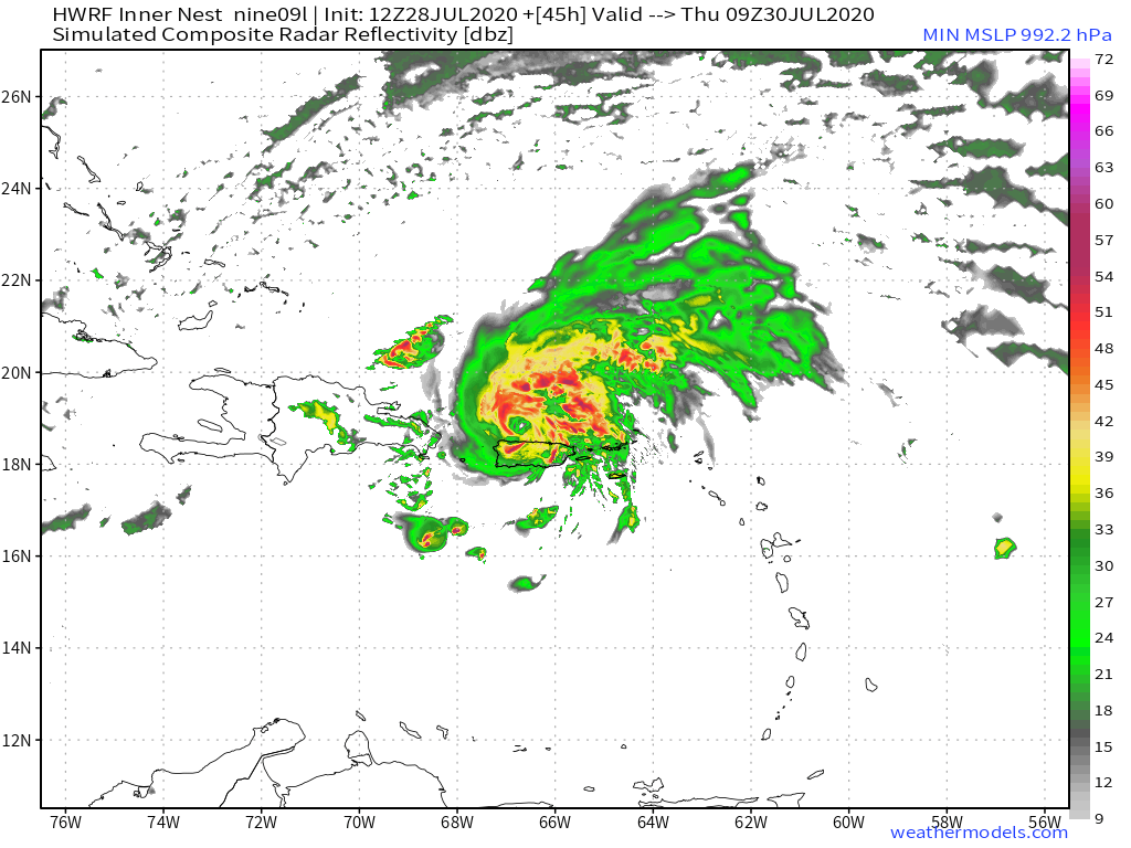
SFLcane

- S2K Supporter
- Posts: 10281
- Age: 48
- Joined: Sat Jun 05, 2010 1:44 pm
- Location: Lake Worth Florida
Re: ATL: NINE - Models
AutoPenalti wrote:Where’s the dry air the HWRF was forecasting within 72hrs?
Hurricane 987mb near Cuba. RH looks good thus far through 50hrs
1 likes
-
supercane4867
- Category 5
- Posts: 4966
- Joined: Wed Nov 14, 2012 10:43 am
-
AutoPenalti
- Category 5
- Posts: 4091
- Age: 29
- Joined: Mon Aug 17, 2015 4:16 pm
- Location: Ft. Lauderdale, Florida
Re: ATL: NINE - Models
SFLcane wrote:AutoPenalti wrote:Where’s the dry air the HWRF was forecasting within 72hrs?
Hurricane 987mb near Cuba. RH looks good thus far through 50hrs
Yikes. Add 4mb for correction and that’s a Cat 1.
Last edited by AutoPenalti on Tue Jul 28, 2020 12:06 pm, edited 1 time in total.
0 likes
The posts in this forum are NOT official forecasts and should not be used as such. They are just the opinion of the poster and may or may not be backed by sound meteorological data. They are NOT endorsed by any professional institution or STORM2K. For official information, please refer to products from the NHC and NWS.
Model Runs Cheat Sheet:
GFS (5:30 AM/PM, 11:30 AM/PM)
HWRF, GFDL, UKMET, NAVGEM (6:30-8:00 AM/PM, 12:30-2:00 AM/PM)
ECMWF (1:45 AM/PM)
TCVN is a weighted averaged
Re: ATL: NINE - Models
I really wouldn't buy in completely on the GFS just poofing the system into nothing, as really no other model does this. In fact, uk now shows strengthening as well as CMC and HWRF. Seeing the miss on Hanna last week should keep everyone's eyes wide open, as we know that particular area of the basin is notorious
2 likes
Who is online
Users browsing this forum: No registered users and 15 guests