

ATL: ISAIAS - Post-Tropical - Discussion
Moderator: S2k Moderators
Re: ATL: NINE - Potential Tropical Cyclone - Discussion
3 likes
Very useful information on the Dvorak Technique --
https://severe.worldweather.wmo.int/TCF ... kBeven.pdf
https://severe.worldweather.wmo.int/TCF ... kBeven.pdf
-
Aric Dunn
- Category 5

- Posts: 21238
- Age: 43
- Joined: Sun Sep 19, 2004 9:58 pm
- Location: Ready for the Chase.
- Contact:
Re: ATL: NINE - Potential Tropical Cyclone - Discussion
SFLcane wrote:Aric Dunn wrote:SFLcane wrote:NHC expects PT9 to become a TS before reaching the islands. We shall see.
so like 4 hours lol
That’s looking highly unlikely at this point.
well not too much longer after that it will be over the islands.
So either they will go off the next ASCAT or surface obs or saw enough of a circ with recon but were waiting more organized convection.
So they technically have 11pm or 2am or 5am at the latest to match up with their forecast.
when is the next recon.. I am assuming just before 5 am ?
1 likes
Note: If I make a post that is brief. Please refer back to previous posts for the analysis or reasoning. I do not re-write/qoute what my initial post said each time.
If there is nothing before... then just ask
Space & Atmospheric Physicist, Embry-Riddle Aeronautical University,
I believe the sky is falling...
If there is nothing before... then just ask
Space & Atmospheric Physicist, Embry-Riddle Aeronautical University,
I believe the sky is falling...

Re: ATL: NINE - Potential Tropical Cyclone - Discussion
Nimbus wrote:What does the surface pressure field look like?
If its shallow broad and elongated there are likely going to be multiple vorts.
Exactly what I'm thinking. Also why I don't buy this very broad low level wind field truly establishing a COC in the 12-18 hr. period that the dynamic models project. As I see it two things will need to happen. 1) Continued convection over or near the broad center of circulation so to better establish a convergent inflow and tighter column of rising air. 2) A lessening of perimeter convection associated with the robust eastern and western mid-level "blobs". These features presently continue to distort and elongate the overall broad low level inflow therefore retarding the process of having a focus vertical column to develop. Prior to yesterday, we hardly had any cenralized concentration of convection at all. I believe it'll take at least 24 hr.'s (probably 36-48) for this to occur. Until then, westward-ho! Regardless, I'm sure NHC will upgrade this to a T.S. tomm even if there isn't a legit COC yet.
4 likes
Andy D
(For official information, please refer to the NHC and NWS products.)
(For official information, please refer to the NHC and NWS products.)
-
Evil Jeremy

- S2K Supporter

- Posts: 5463
- Age: 32
- Joined: Mon Apr 10, 2006 2:10 pm
- Location: Los Angeles, CA
Re: ATL: NINE - Potential Tropical Cyclone - Discussion
Aric Dunn wrote:SFLcane wrote:Aric Dunn wrote:
so like 4 hours lol
That’s looking highly unlikely at this point.
well not too much longer after that it will be over the islands.
I think next recon takes off at 7:45am
So either they will go off the next ASCAT or surface obs or saw enough of a circ with recon but were waiting more organized convection.
So they technically have 11pm or 2am or 5am at the latest to match up with their forecast.
when is the next recon.. I am assuming just before 5 am ?
I think recon takes off at 7:45am.... Cycloneye, correct me below if I’m wrong
Last edited by Evil Jeremy on Tue Jul 28, 2020 6:36 pm, edited 2 times in total.
0 likes
Frances 04 / Jeanne 04 / Katrina 05 / Wilma 05 / Fay 08 / Debby 12 / Andrea 13 / Colin 16 / Hermine 16 / Matthew 16 / Irma 17
-
cycloneye

- Admin

- Posts: 148733
- Age: 69
- Joined: Thu Oct 10, 2002 10:54 am
- Location: San Juan, Puerto Rico
Re: ATL: NINE - Potential Tropical Cyclone - Discussion
Aric Dunn wrote:SFLcane wrote:Aric Dunn wrote:
so like 4 hours lol
That’s looking highly unlikely at this point.
well not too much longer after that it will be over the islands.
So either they will go off the next ASCAT or surface obs or saw enough of a circ with recon but were waiting more organized convection.
So they technically have 11pm or 2am or 5am at the latest to match up with their forecast.
when is the next recon.. I am assuming just before 5 am ?
Next flight departs at 11:45 PM.
3 likes
Visit the Caribbean-Central America Weather Thread where you can find at first post web cams,radars
and observations from Caribbean basin members Click Here
and observations from Caribbean basin members Click Here
-
SFLcane

- S2K Supporter
- Posts: 10281
- Age: 48
- Joined: Sat Jun 05, 2010 1:44 pm
- Location: Lake Worth Florida
Re: ATL: NINE - Potential Tropical Cyclone - Discussion
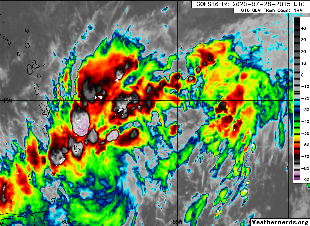
Look at the lighting..I think we may have a developing well defined circulation.
5 likes
-
sphelps8681
- Category 2

- Posts: 785
- Joined: Thu Aug 16, 2007 5:37 pm
- Location: Somewhere over the rainbow
Re: ATL: NINE - Potential Tropical Cyclone - Discussion
So how far west if we know will this make it to the gulf or will it be a curve eastward?
2 likes
Re: ATL: NINE - Potential Tropical Cyclone - Discussion
Aric Dunn wrote:SFLcane wrote:NHC expects PT9 to become a TS before reaching the islands. We shall see.
so like 4 hours lol
Right?! I think not. (regardless whether it's tagged a T.S. of not)
0 likes
Andy D
(For official information, please refer to the NHC and NWS products.)
(For official information, please refer to the NHC and NWS products.)


Re: ATL: NINE - Potential Tropical Cyclone - Discussion
92L is somewhat disorganized but the conundrum of tropical forecasting is all systems look disorganized until they aren't
4 likes
-
Aric Dunn
- Category 5
- Posts: 21238
- Age: 43
- Joined: Sun Sep 19, 2004 9:58 pm
- Location: Ready for the Chase.
- Contact:
Re: ATL: NINE - Potential Tropical Cyclone - Discussion
SFLcane wrote:Look at the lighting..I think we may have a developing well defined circulation.
https://iili.io/dAvzml.gif
well the llc was already there earlier. just had the boundary that was attached to the lobe to the NE.
if we are seeing this type of convection wrapping around.. likely means the boundary has broken down and the low level flow/convergence around the llc has begun to increase in those lacking quads.
1 likes
Note: If I make a post that is brief. Please refer back to previous posts for the analysis or reasoning. I do not re-write/qoute what my initial post said each time.
If there is nothing before... then just ask
Space & Atmospheric Physicist, Embry-Riddle Aeronautical University,
I believe the sky is falling...
If there is nothing before... then just ask
Space & Atmospheric Physicist, Embry-Riddle Aeronautical University,
I believe the sky is falling...
Re: ATL: NINE - Potential Tropical Cyclone - Discussion
Freeport-tx3738 wrote:Hey I need yalls expert weather advice. You think I would be able to dodge the next storm cause I am gonna fly to ft Lauderdale on Saturday evening.
Think I will make it there before it gets too bad?
As a passenger on a commercial flight? All things considered at this moment in time, I'd consider chancing it. 1) A lot of variables in play but present circumstances allow for a decent margin of error when discussing a 96 hr forecast. 2) Present forecast is for a weak T.S. to approach S. Florida. Could be weaker but could also be stronger. Commercial flights already have protocols for a wide range of weather conditions and would not risk landing if conditions were deemed unsafe.
If you are a pilot and we were talking about flying a small plane however, I would not plan that flight given the potential for hazardous flight conditions.
3 likes
Andy D
(For official information, please refer to the NHC and NWS products.)
(For official information, please refer to the NHC and NWS products.)
-
SFLcane
- S2K Supporter
- Posts: 10281
- Age: 48
- Joined: Sat Jun 05, 2010 1:44 pm
- Location: Lake Worth Florida
Re: ATL: NINE - Potential Tropical Cyclone - Discussion
Whattt... moving at 25 mph at 8pm. No way this closes off I just don’t know.
3 likes

Re: ATL: NINE - Potential Tropical Cyclone - Discussion
Hard for recon to close off a center with that forward speed. Hard to find west winds often when a system is moving that fast.
SFLcane wrote:Whattt... moving at 25 mph at 8pm. No way this closes off I just don’t know.
4 likes
-
Evil Jeremy
- S2K Supporter
- Posts: 5463
- Age: 32
- Joined: Mon Apr 10, 2006 2:10 pm
- Location: Los Angeles, CA
Re: ATL: NINE - Potential Tropical Cyclone - Discussion
sgastorm wrote:Hard for recon to close off a center with that forward speed. Hard to find west winds often when a system is moving that fast.SFLcane wrote:Whattt... moving at 25 mph at 8pm. No way this closes off I just don’t know.
Not often you can say a storm/wave/whatever is being it's own worst enemy.
3 likes
Frances 04 / Jeanne 04 / Katrina 05 / Wilma 05 / Fay 08 / Debby 12 / Andrea 13 / Colin 16 / Hermine 16 / Matthew 16 / Irma 17
-
Blown Away

- S2K Supporter
- Posts: 10253
- Joined: Wed May 26, 2004 6:17 am
Re: ATL: NINE - Potential Tropical Cyclone - Discussion
SFLcane wrote:Whattt... moving at 25 mph at 8pm. No way this closes off I just don’t know.
Plus they adjusted the position a little S which makes land interaction more possible.
2 likes
Hurricane Eye Experience: David 79, Irene 99, Frances 04, Jeanne 04, Wilma 05… Hurricane Brush Experience: Andrew 92, Erin 95, Floyd 99, Matthew 16, Irma 17, Ian 22, Nicole 22…
-
AnnularCane

- S2K Supporter
- Posts: 2949
- Joined: Thu Jun 08, 2006 9:18 am
- Location: Wytheville, VA
Re: ATL: NINE - Potential Tropical Cyclone - Discussion
Is this expected to slow down at any point?
3 likes

Re: ATL: NINE - Potential Tropical Cyclone - Discussion
That southward center fix for the 8pm intermediate advisory is going to throw every previous model solution into a paper shredder. Who knows what’s even going to come out of this now? Will it even get far enough north to bring impacts to the Greater Antilles or the Bahamas?
5 likes
Irene '11 Sandy '12 Hermine '16 5/15/2018 Derecho Fay '20 Isaias '20 Elsa '21 Henri '21 Ida '21
I am only a meteorology enthusiast who knows a decent amount about tropical cyclones. Look to the professional mets, the NHC, or your local weather office for the best information.
I am only a meteorology enthusiast who knows a decent amount about tropical cyclones. Look to the professional mets, the NHC, or your local weather office for the best information.

Re: ATL: NINE - Potential Tropical Cyclone - Discussion
It's always funny when this happens. 

11 likes
Igor 2010, Sandy 2012, Fay 2014, Gonzalo 2014, Joaquin 2015, Nicole 2016, Humberto 2019, Imelda 2025
I am only a tropical weather enthusiast. My predictions are not official and may or may not be backed by sound meteorological data. For official information, please refer to the NHC and NWS products.
I am only a tropical weather enthusiast. My predictions are not official and may or may not be backed by sound meteorological data. For official information, please refer to the NHC and NWS products.
-
Blown Away
- S2K Supporter
- Posts: 10253
- Joined: Wed May 26, 2004 6:17 am
Re: ATL: NINE - Potential Tropical Cyclone - Discussion
aspen wrote:That southward center fix for the 8pm intermediate advisory is going to throw every previous model solution into a paper shredder. Who knows what’s even going to come out of this now? Will it even get far enough north to bring impacts to the Greater Antilles or the Bahamas?
Yep, Hispaniola is waiting to consume PTC#9... Euro may be right once again...
2 likes
Hurricane Eye Experience: David 79, Irene 99, Frances 04, Jeanne 04, Wilma 05… Hurricane Brush Experience: Andrew 92, Erin 95, Floyd 99, Matthew 16, Irma 17, Ian 22, Nicole 22…

Re: ATL: NINE - Potential Tropical Cyclone - Discussion
Well, despite its forward speed, PTC 9 atm has started a WNW movement.
Per NHC:
8:00 PM AST Tue Jul 28
Location: 14.2°N 58.7°W
Moving: WNW at 25 mph
Min pressure: 1007 mb
Max sustained: 40 mph
Per NHC:
8:00 PM AST Tue Jul 28
Location: 14.2°N 58.7°W
Moving: WNW at 25 mph
Min pressure: 1007 mb
Max sustained: 40 mph
2 likes
The posts or stuff said are NOT an official forecast. Please look to the NHC and NWS for official forecasts and products.
Floyd-1999, Frances-2004, Jeanne-2004, Fay-2008, Beryl-2012, Debby-2012, Colin-2016, Hermine-2016, Julia-2016, Matthew-2016, Irma-2017, Elsa-2021, Idalia-2023, Debby-2024, Helene-2024.
Go Gators! Go Jags!
Floyd-1999, Frances-2004, Jeanne-2004, Fay-2008, Beryl-2012, Debby-2012, Colin-2016, Hermine-2016, Julia-2016, Matthew-2016, Irma-2017, Elsa-2021, Idalia-2023, Debby-2024, Helene-2024.
Go Gators! Go Jags!
Who is online
Users browsing this forum: No registered users and 16 guests