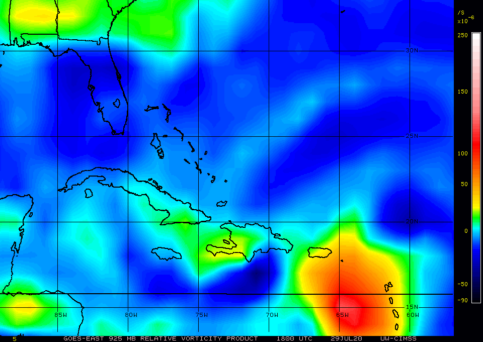
ATL: ISAIAS - Post-Tropical - Discussion

Moderator: S2k Moderators

Message
Author
jaxfladude
Category 5
Category 5
Posts: 1249
Joined: Wed Aug 24, 2005 9:36 pm
Location: Jacksonville, Fla

Re: ATL: NINE - Potential Tropical Cyclone - Discussion

#1461 Postby jaxfladude » Wed Jul 29, 2020 2:08 pm

EDIT to add:

northjaxpro wrote:
Aric Dunn wrote:That curved band of deepening convection on the WEST and SW/ S sides is very interesting..


I thought and posted earlier this morning and I have and still believe that the center of circulation is on the southwestern dide or very near there of the convective mass.

I think when Recon FINALLY closes this thing off, I feel it will be a tad SSW of where they think it is currently.

I tell you one thing, this thing is giving me a major headache. I sm groeing a biy weary with this waiting game for sure... :double:


So is this finally the start of the oh bleep or is it roughly going as forecast as it is possible to do so?
1 likes   
Stay safe y'all

User avatar
gatorcane
S2K Supporter
S2K Supporter
Posts: 23692
Age: 47
Joined: Sun Mar 13, 2005 3:54 pm
Location: Boca Raton, FL

Re: ATL: NINE - Potential Tropical Cyclone - Discussion

#1462 Postby gatorcane » Wed Jul 29, 2020 2:15 pm

Continues to organize:

Image
7 likes   

User avatar
northjaxpro
S2K Supporter
S2K Supporter
Posts: 8900
Joined: Mon Sep 27, 2010 11:21 am
Location: Jacksonville, FL

Re: ATL: NINE - Potential Tropical Cyclone - Discussion

#1463 Postby northjaxpro » Wed Jul 29, 2020 2:15 pm

jaxfladude wrote:EDIT to add:

northjaxpro wrote:
Aric Dunn wrote:That curved band of deepening convection on the WEST and SW/ S sides is very interesting..


I thought and posted earlier this morning and I have and still believe that the center of circulation is on the southwestern dide or very near there of the convective mass.

I think when Recon FINALLY closes this thing off, I feel it will be a tad SSW of where they think it is currently.

I tell you one thing, this thing is giving me a major headache. I sm groeing a biy weary with this waiting game for sure... :double:


So is this finally the start of the oh bleep or is it roughly going as forecast as it is possible to do so?


Don't know yet. We just need confirmation from Recon one way or the other about this crazy system. We are just in a holding pattern still at this time unfortunately.
3 likes   
NEVER, EVER SAY NEVER in the tropics and weather in general, and most importantly, with life itself!!

________________________________________________________________________________________

Fay 2008 Beryl 2012 Debby 2012 Colin 2016 Hermine 2016 Julia 2016 Matthew 2016 Irma 2017 Dorian 2019

wx98
Category 5
Category 5
Posts: 1383
Joined: Sat Aug 25, 2018 9:24 pm

Re: ATL: NINE - Potential Tropical Cyclone - Discussion

#1464 Postby wx98 » Wed Jul 29, 2020 2:18 pm

Hammy wrote:This has been closed off for about the last 12 hours and is already a tropical storm if the plane would actually fly around 13-14N, that's where the west winds are--ASCAT even confirms this. Not sure why they're waiting for a low to form in the northern portion when there's already one to the south.

https://i.imgur.com/sgO7BOY.jpg


That is hardly a well-defined surface circulation worthy of being called a tropical storm.
0 likes   

User avatar
SFLcane
S2K Supporter
S2K Supporter
Posts: 10163
Age: 47
Joined: Sat Jun 05, 2010 1:44 pm
Location: Lake Worth Florida

Re: ATL: NINE - Potential Tropical Cyclone - Discussion

#1465 Postby SFLcane » Wed Jul 29, 2020 2:19 pm


This is a great loop! Sure looks to be organizing. Outflow improving not to far from being classified.
4 likes   

User avatar
CFLHurricane
Category 1
Category 1
Posts: 346
Joined: Thu Mar 27, 2014 5:56 pm
Location: Floriduh

Re: ATL: NINE - Potential Tropical Cyclone - Discussion

#1466 Postby CFLHurricane » Wed Jul 29, 2020 2:21 pm

wx98 wrote:
Hammy wrote:This has been closed off for about the last 12 hours and is already a tropical storm if the plane would actually fly around 13-14N, that's where the west winds are--ASCAT even confirms this. Not sure why they're waiting for a low to form in the northern portion when there's already one to the south.

https://i.imgur.com/sgO7BOY.jpg


That is hardly a well-defined surface circulation worthy of being called a tropical storm.


The satellite presentation this afternoon appears to have a vigorous closed vortex. It just needs to finish absorbing its twin and we’re go for liftoff.
3 likes   
I'm not a meteorologist, but I did stay at a motel 8.

User avatar
tiger_deF
Category 1
Category 1
Posts: 468
Age: 24
Joined: Tue Sep 27, 2016 11:47 am

Re: ATL: NINE - Potential Tropical Cyclone - Discussion

#1467 Postby tiger_deF » Wed Jul 29, 2020 2:22 pm

Surface vort looking significantly improved

Image
1 likes   

User avatar
ScottNAtlanta
Category 5
Category 5
Posts: 2374
Joined: Sat May 25, 2013 3:11 pm
Location: Atlanta, GA

Re: ATL: NINE - Potential Tropical Cyclone - Discussion

#1468 Postby ScottNAtlanta » Wed Jul 29, 2020 2:26 pm

I think it is forming a center close to 15N 65W.
There are also ship reports to the west that show N and NW winds
1 likes   
The posts in this forum are NOT official forecast and should not be used as such. They are just the opinion of the poster and may or may not be backed by sound meteorological data. They are NOT endorsed by any professional institution or storm2k.org. For official information, please refer to the NHC and NWS products.

User avatar
Hammy
Category 5
Category 5
Posts: 5849
Age: 42
Joined: Fri May 25, 2012 5:25 pm
Contact:

Re: ATL: NINE - Potential Tropical Cyclone - Discussion

#1469 Postby Hammy » Wed Jul 29, 2020 2:26 pm

wx98 wrote:
Hammy wrote:This has been closed off for about the last 12 hours and is already a tropical storm if the plane would actually fly around 13-14N, that's where the west winds are--ASCAT even confirms this. Not sure why they're waiting for a low to form in the northern portion when there's already one to the south.

https://i.imgur.com/sgO7BOY.jpg


That is hardly a well-defined surface circulation worthy of being called a tropical storm.


Most faster-moving large systems like this are poorly defined and Isaac in 2012 was less organized than this (even lacking a center most of it's time in the Caribbean) and was designated a storm and maintained as such.

The main point is if they're waiting for the northern portion to close off they may as well lower the chances to 0% because that's not where the center is at in the first place.
2 likes   
The above post is not official and should not be used as such. It is the opinion of the poster and may or may not be backed by sound meteorological data. It is not endorsed by any professional institution or storm2k.org. For official information, please refer to the NHC and NWS products.

User avatar
HurricaneEnzo
Category 2
Category 2
Posts: 739
Joined: Wed Mar 14, 2018 12:18 pm
Location: Newport, NC (Hurricane Alley)

Re: ATL: NINE - Potential Tropical Cyclone - Discussion

#1470 Postby HurricaneEnzo » Wed Jul 29, 2020 2:28 pm

Yeah this storm has fooled me a couple of times already. I'm currently adopting a wait and see approach. Does look to be trying another run at getting its act together but it has done this several times only to fail. Maybe it will get the job done this time.
5 likes   
Bertha 96' - Fran 96' - Bonnie 98' - Dennis 99' - Floyd 99' - Isabel 03' - Alex 04' - Ophelia 05' - Irene 11' - Arthur 14' - Matthew 16' - Florence 18' - Dorian 19' - Isaias 20' (countless other tropical storms and Hurricane swipes)

I am not a Professional Met just an enthusiast. Get your weather forecasts from the Pros!

User avatar
gatorcane
S2K Supporter
S2K Supporter
Posts: 23692
Age: 47
Joined: Sun Mar 13, 2005 3:54 pm
Location: Boca Raton, FL

Re: ATL: NINE - Potential Tropical Cyclone - Discussion

#1471 Postby gatorcane » Wed Jul 29, 2020 2:33 pm

ScottNAtlanta wrote:I think it is forming a center close to 15N 65W.
There are also ship reports to the west that show N and NW winds


I'd go a smidge more north around 16N. It's broad but just taking a step back and looking at the Sat imagery (link below), I would probably pull the trigger and name 92L for the 5pm advisory. I know NHC likes to go with data from the plane to be sure but it certainly looks like more than a wave when you look at the sat imagery and the spin.

https://www.tropicaltidbits.com/sat/sat ... t=vis-swir
5 likes   

User avatar
northjaxpro
S2K Supporter
S2K Supporter
Posts: 8900
Joined: Mon Sep 27, 2010 11:21 am
Location: Jacksonville, FL

Re: ATL: NINE - Potential Tropical Cyclone - Discussion

#1472 Postby northjaxpro » Wed Jul 29, 2020 2:36 pm

Hammy wrote:
wx98 wrote:
Hammy wrote:This has been closed off for about the last 12 hours and is already a tropical storm if the plane would actually fly around 13-14N, that's where the west winds are--ASCAT even confirms this. Not sure why they're waiting for a low to form in the northern portion when there's already one to the south.

https://i.imgur.com/sgO7BOY.jpg


That is hardly a well-defined surface circulation worthy of being called a tropical storm.


Most faster-moving large systems like this are poorly defined and Isaac in 2012 was less organized than this (even lacking a center most of it's time in the Caribbean) and was designated a storm and maintained as such.

The main point is if they're waiting for the northern portion to close off they may as well lower the chances to 0% because that's not where the center is at in the first place.


Yes, I have been though since early this morning that the center has been on the SW side of this system. I have been somewhat stumped as to how Recon has not been able to close this thing off to this point.

But I respect these guys so much so I do not want to harp on this too much. However, I just hope they will get a consensus of this thing will do one way or the other. Let's all hope this will be very soon.
Last edited by northjaxpro on Wed Jul 29, 2020 2:38 pm, edited 1 time in total.
3 likes   
NEVER, EVER SAY NEVER in the tropics and weather in general, and most importantly, with life itself!!

________________________________________________________________________________________

Fay 2008 Beryl 2012 Debby 2012 Colin 2016 Hermine 2016 Julia 2016 Matthew 2016 Irma 2017 Dorian 2019

USTropics
Professional-Met
Professional-Met
Posts: 2659
Joined: Sun Aug 12, 2007 3:45 am
Location: Florida State University

Re: ATL: NINE - Potential Tropical Cyclone - Discussion

#1473 Postby USTropics » Wed Jul 29, 2020 2:37 pm

Classic example of how a wave axis entering the eastern Caribbean goes from a NE to SW tilt, to N to S orientation, and now rotating the axis NW to SE. This is typically when we have the highest vort max at the low-levels (which is what is occurring):

Image

The main inhibiting factor? The system is having a difficult time becoming vertically stacked, and the large, elongated circulation hasn't helped matters. For one, the pressure gradient and brisk flow at the mid-levels to the north is stretching the vorticity out, hindering consolidation:
Image
Image

Secondly, the low-level flow and poor organization has kept the storm at a brisk pace. Check out the correction to forward speed in the past 3 days (12 runs) of the GFS:
Image

This has left the upper-level axis of the wave a bit behind, where it has favored the divergent flow on the SW axis of the wave. This has become a bit elongated in the past few frames, which most likely means upper-level vorticity will attempt to concentrate over the new LLC. It's been a slow process, but the signs of a center finally coming together are there:
Image
19 likes   

User avatar
SoupBone
Category 5
Category 5
Posts: 3111
Joined: Tue Sep 20, 2005 5:24 pm

Re: ATL: NINE - Potential Tropical Cyclone - Discussion

#1474 Postby SoupBone » Wed Jul 29, 2020 2:41 pm

northjaxpro wrote:
Aric Dunn wrote:That curved band of deepening convection on the WEST and SW/ S sides is very interesting..


I thought and posted earlier this morning and I have and still believe that the center of circulation is on the southwestern side or very near there of the convective mass.

I think when Recon FINALLY closes this thing off, I feel it will be a tad SSW of where they think it is currently.

I tell you one thing, this thing is giving me a major headache. I am growing a bit weary with this waiting game for sure... :double:


This is one of those systems that gives us all headaches, even the Pro-Mets here I think. :lol:

And wait for it..........it's still July. :D
0 likes   
Personal Forecast Disclaimer:
The posts in this forum are NOT official forecast and should not be used as such. They are just the opinion of the poster and may or may not be backed by sound meteorological data. They are NOT endorsed by any professional institution or storm2k.org. For official information, please refer to the NHC and NWS products.

User avatar
CourierPR
Category 5
Category 5
Posts: 1335
Age: 71
Joined: Tue Aug 31, 2004 7:53 pm
Location: Pompano Beach, Florida

Re: ATL: NINE - Potential Tropical Cyclone - Discussion

#1475 Postby CourierPR » Wed Jul 29, 2020 2:45 pm

PTC 9 appears to be getting better organized as I type and it is large.
1 likes   

User avatar
ScottNAtlanta
Category 5
Category 5
Posts: 2374
Joined: Sat May 25, 2013 3:11 pm
Location: Atlanta, GA

Re: ATL: NINE - Potential Tropical Cyclone - Discussion

#1476 Postby ScottNAtlanta » Wed Jul 29, 2020 2:47 pm

I am still not buying north of Hispaniola. The vorticity is concentrating on the southern end, and as time is passing it would have to make a more prominent turn in the NW direction to do that and I see no mechanism to force that. I believe the models have been initializing this too far north and thus are not correct.
There is a hot tower going off right over where I think the center is forming. There is also some low level flow bending toward it.
FYI...I still like my earlier track towards Jamaica
Last edited by ScottNAtlanta on Wed Jul 29, 2020 2:54 pm, edited 1 time in total.
8 likes   
The posts in this forum are NOT official forecast and should not be used as such. They are just the opinion of the poster and may or may not be backed by sound meteorological data. They are NOT endorsed by any professional institution or storm2k.org. For official information, please refer to the NHC and NWS products.

User avatar
GCANE
S2K Supporter
S2K Supporter
Posts: 11501
Joined: Mon Oct 22, 2007 8:03 am

Re: ATL: NINE - Potential Tropical Cyclone - Discussion

#1477 Postby GCANE » Wed Jul 29, 2020 2:49 pm

Minimal and very broad warm core with a large boundary-layer inversion.
In other words, it just can't get its act together.

Image
0 likes   

User avatar
gatorcane
S2K Supporter
S2K Supporter
Posts: 23692
Age: 47
Joined: Sun Mar 13, 2005 3:54 pm
Location: Boca Raton, FL

Re: ATL: NINE - Potential Tropical Cyclone - Discussion

#1478 Postby gatorcane » Wed Jul 29, 2020 2:50 pm

Here comes the shortwave over the plains heading east which should erode the Bermuda High enough to allow 92L to turn more NW in a few days:

http://rammb.cira.colostate.edu/ramsdis ... display=24
Last edited by gatorcane on Wed Jul 29, 2020 2:53 pm, edited 1 time in total.
1 likes   

User avatar
ScottNAtlanta
Category 5
Category 5
Posts: 2374
Joined: Sat May 25, 2013 3:11 pm
Location: Atlanta, GA

Re: ATL: NINE - Potential Tropical Cyclone - Discussion

#1479 Postby ScottNAtlanta » Wed Jul 29, 2020 2:53 pm

gatorcane wrote:Here comes the shortwave over the plains heading east which should erode the Bermuda High enough to allow 92L to turn more NW in couple of days:

http://rammb.cira.colostate.edu/ramsdis ... display=24

At the speed the shortwave is moving, it might move out before this gets there.
0 likes   
The posts in this forum are NOT official forecast and should not be used as such. They are just the opinion of the poster and may or may not be backed by sound meteorological data. They are NOT endorsed by any professional institution or storm2k.org. For official information, please refer to the NHC and NWS products.

User avatar
NDG
S2K Supporter
S2K Supporter
Posts: 15446
Joined: Sun Jul 09, 2006 10:14 pm
Location: Orlando, FL

Re: ATL: NINE - Potential Tropical Cyclone - Discussion

#1480 Postby NDG » Wed Jul 29, 2020 2:53 pm

If the system indeed takes the persistent track that the Euro has been forecasting run after run, north of Cuba, whoever thinks is going to have SW shear to deal with is lying to themselves. With the trough axis all the way west over the MS river valley it should have fairly good UL conditions.
Remember how bad they were with the intensity of Hanna 2-3 days before making landfall.
6 likes   


Return to “2020”

Who is online

Users browsing this forum: No registered users and 24 guests