ATL: ISAIAS - Models
Moderator: S2k Moderators


Re: ATL: NINE - Models
AutoPenalti wrote:NDG wrote:12z EPS is trending towards a deeper trough over the MS rive valley to erode the western end of the narrow ridge to its north when it gets close to FL, but at the same time it keeps trending towards the Bermuda ridge expanding northward to block PTC9 from going OTS.
https://i.imgur.com/o4CcoR1.gif
https://i.imgur.com/7JrvTnW.gif
Wowzers, that trough is unusual for August.
It definitely is, but this season also started early. Maybe it was an indicator that other seasonal meteorology things are also coming in slightly earlier this year. Wouldn't be the first time.
0 likes
Personal Forecast Disclaimer:
The posts in this forum are NOT official forecast and should not be used as such. They are just the opinion of the poster and may or may not be backed by sound meteorological data. They are NOT endorsed by any professional institution or storm2k.org. For official information, please refer to the NHC and NWS products.
The posts in this forum are NOT official forecast and should not be used as such. They are just the opinion of the poster and may or may not be backed by sound meteorological data. They are NOT endorsed by any professional institution or storm2k.org. For official information, please refer to the NHC and NWS products.
-
gatorcane

- S2K Supporter

- Posts: 23708
- Age: 48
- Joined: Sun Mar 13, 2005 3:54 pm
- Location: Boca Raton, FL
Re: ATL: NINE - Models
caneseddy wrote:ICON has landfall as a Cat 1 around Palm Beach County
https://www.tropicaltidbits.com/analysis/models/icon/2020072918/icon_mslp_pcpn_watl_26.png
Between 69 and 81 hours it drops 7MB as it moves over the Gulf stream. This is a change from prior runs which showed weakening on the approach.
Last edited by gatorcane on Wed Jul 29, 2020 4:22 pm, edited 1 time in total.
0 likes

Re: ATL: NINE - Models
ronjon wrote:Models coming into rough consensus of a track somewhere off the east coast. How many times has this happened in the past? Too many times to count. For whatever reason, storms more times than not recurve east of the peninsula. Things can change of course in the next few days. But if it does stay off the east coast of FL, seems like the GFS-para would have done the best with sniffing this out early. Time will tell...
GFS-Para has been trending to the left, will probably continue to do so, closer to the Euro and rest of the models.

0 likes
-
DestinHurricane

- Category 4

- Posts: 935
- Joined: Tue May 01, 2018 8:05 am
- Location: New York, NY
Re: ATL: NINE - Models
What is making some of these models very bullish? Seems like they are overestimating the situation.
0 likes
Michael 2018
-
gatorcane
- S2K Supporter
- Posts: 23708
- Age: 48
- Joined: Sun Mar 13, 2005 3:54 pm
- Location: Boca Raton, FL
Re: ATL: NINE - Models
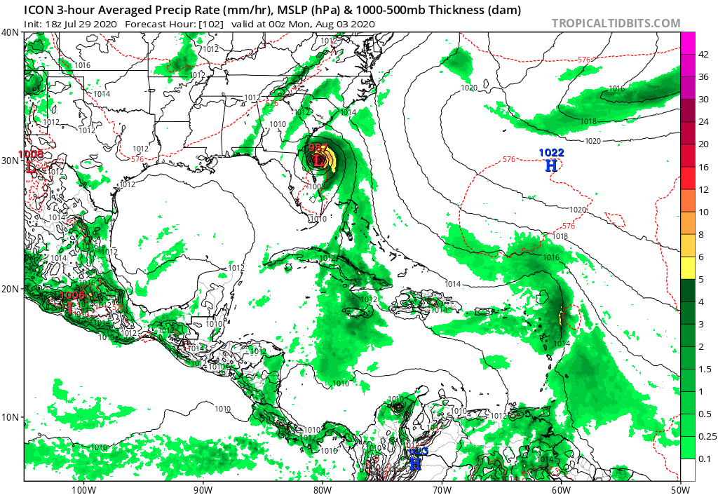
ICON down to 987MB just east of Jax at 102 hours. Looks like it briefly weakened while it skimmed the FL east coast.
0 likes
Re: ATL: NINE - Models
AutoPenalti wrote:NDG wrote:12z EPS is trending towards a deeper trough over the MS rive valley to erode the western end of the narrow ridge to its north when it gets close to FL, but at the same time it keeps trending towards the Bermuda ridge expanding northward to block PTC9 from going OTS.
https://i.imgur.com/o4CcoR1.gif
https://i.imgur.com/7JrvTnW.gif
Wowzers, that trough is unusual for August.
It has happened in the past with Charley in 2004, which is why it took that hard right into Port Charlotte/Punta Gorda
0 likes
-
ColdMiser123

- Professional-Met

- Posts: 905
- Age: 29
- Joined: Mon Sep 26, 2016 3:26 pm
- Location: Northeast US
Re: ATL: NINE - Models
Looks like a South Carolina landfall after grazing east Florida on the ICON as a hurricane. Quite a change from previous runs as others have already noted.
0 likes
B.S., M.S., Meteorology & Atmospheric Science
-
gatorcane
- S2K Supporter
- Posts: 23708
- Age: 48
- Joined: Sun Mar 13, 2005 3:54 pm
- Location: Boca Raton, FL
Re: ATL: NINE - Models
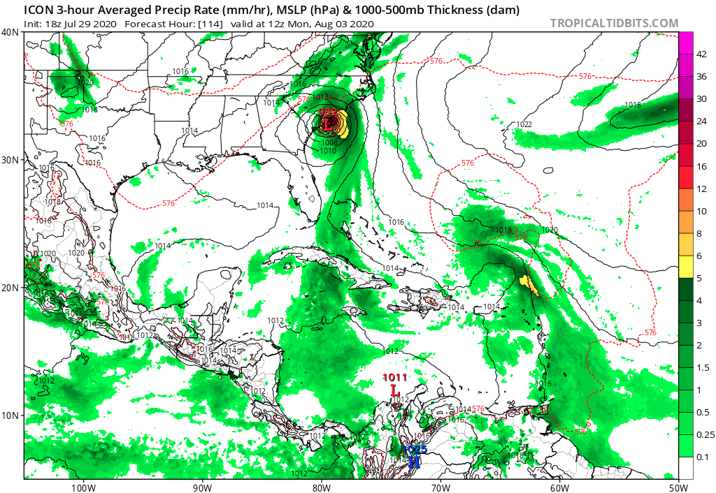
18Z ICON with second landfall in SC at 982MB. BIG change from previous ICON run which kept this weak.
0 likes
-
Evil Jeremy

- S2K Supporter
- Posts: 5463
- Age: 32
- Joined: Mon Apr 10, 2006 2:10 pm
- Location: Los Angeles, CA
Re: ATL: NINE - Models
DestinHurricane wrote:What is making some of these models very bullish? Seems like they are overestimating the situation.
Clearly they didn't hear you declaring the storm cancelled this morning.
That, or perhaps the Bahamas are ripe with hot waters. NHC noted in their 5pm discussion that "some of the global models are now showing a track farther
away from eastern Cuba and east of Florida, and if that occurs the
NHC intensity forecast could be somewhat conservative"
6 likes
Frances 04 / Jeanne 04 / Katrina 05 / Wilma 05 / Fay 08 / Debby 12 / Andrea 13 / Colin 16 / Hermine 16 / Matthew 16 / Irma 17
Re: ATL: NINE - Models
AutoPenalti wrote:NDG wrote:12z EPS is trending towards a deeper trough over the MS rive valley to erode the western end of the narrow ridge to its north when it gets close to FL, but at the same time it keeps trending towards the Bermuda ridge expanding northward to block PTC9 from going OTS.
https://i.imgur.com/o4CcoR1.gif
https://i.imgur.com/7JrvTnW.gif
Wowzers, that trough is unusual for August.
Don't forget about the unusual deep trough that pulled Charely out of the Caribbean in mid August 2004, it was deeper than this one coming down this weekend.
I lived in Nola back then, I remember lows in the 60s for a couple mornings when that trough came down.

4 likes
Re: ATL: NINE - Models
NDG wrote:AutoPenalti wrote:NDG wrote:12z EPS is trending towards a deeper trough over the MS rive valley to erode the western end of the narrow ridge to its north when it gets close to FL, but at the same time it keeps trending towards the Bermuda ridge expanding northward to block PTC9 from going OTS.
https://i.imgur.com/o4CcoR1.gif
https://i.imgur.com/7JrvTnW.gif
Wowzers, that trough is unusual for August.
Don't forget about the unusual deep trough that pulled Charely out of the Caribbean in mid August 2004, it was deeper than this one coming down this weekend.
I lived in Nola back then, I remember lows in the 60s for a couple mornings when that trough came down.
https://i.imgur.com/A1h9Pic.gif
I recall one from late July 2014 that brought some really nice, cool weather for 3-4 days. It was unreal, felt like Fall for those few days. It's not like the Earth knows it's only July.
1 likes
Personal Forecast Disclaimer:
The posts in this forum are NOT official forecast and should not be used as such. They are just the opinion of the poster and may or may not be backed by sound meteorological data. They are NOT endorsed by any professional institution or storm2k.org. For official information, please refer to the NHC and NWS products.
The posts in this forum are NOT official forecast and should not be used as such. They are just the opinion of the poster and may or may not be backed by sound meteorological data. They are NOT endorsed by any professional institution or storm2k.org. For official information, please refer to the NHC and NWS products.
-
gatorcane
- S2K Supporter
- Posts: 23708
- Age: 48
- Joined: Sun Mar 13, 2005 3:54 pm
- Location: Boca Raton, FL
Re: ATL: NINE - Models
18Z GFS again forms the circulation just north of the DR at 24 hours.
0 likes
-
jlauderdal
- S2K Supporter
- Posts: 7240
- Joined: Wed May 19, 2004 5:46 am
- Location: NE Fort Lauderdale
- Contact:
Re: RE: Re: ATL: NINE - Models
Yes, hurricanes dont plow through ridges, if strong enough they nudge the ridge but they cant bust through it like a dam breakingpgoss11 wrote:NDG wrote:12z EPS is trending towards a deeper trough over the MS rive valley to erode the western end of the narrow ridge to its north when it gets close to FL, but at the same time it keeps trending towards the Bermuda ridge expanding northward to block PTC9 from going OTS.
https://i.imgur.com/o4CcoR1.gif
https://i.imgur.com/7JrvTnW.gif
Meaning ?? It’s gets trapped from going out to sea and forced inland somewhere along the eastern seaboard?
1 likes
-
jlauderdal
- S2K Supporter
- Posts: 7240
- Joined: Wed May 19, 2004 5:46 am
- Location: NE Fort Lauderdale
- Contact:
Re: RE: Re: ATL: NINE - Models
Yep, what happened to the shear and dry air on approach?gatorcane wrote:caneseddy wrote:ICON has landfall as a Cat 1 around Palm Beach County
https://www.tropicaltidbits.com/analysis/models/icon/2020072918/icon_mslp_pcpn_watl_26.png
Between 69 and 81 hours it drops 7MB as it moves over the Gulf stream. This is a change from prior runs which showed weakening on the approach.
0 likes
-
WeatherEmperor
- S2K Supporter
- Posts: 4806
- Age: 41
- Joined: Thu Sep 04, 2003 2:54 pm
- Location: South Florida
Re: ATL: NINE - Models
GFS is a hair further north than before. Perhaps it will turn north further east away from FL??

Sent from my iPhone using Tapatalk
Sent from my iPhone using Tapatalk
0 likes
-
DestinHurricane
- Category 4
- Posts: 935
- Joined: Tue May 01, 2018 8:05 am
- Location: New York, NY
Re: ATL: NINE - Models
I don't think the models mean anything until we have a center. Looks like the center will be further south than the models are initializing.
5 likes
Michael 2018
-
Evil Jeremy
- S2K Supporter
- Posts: 5463
- Age: 32
- Joined: Mon Apr 10, 2006 2:10 pm
- Location: Los Angeles, CA
Re: ATL: NINE - Models
18z GFS is a solid chunk NE of the 12z run through 66 hours. Staying well off the Florida east coast.
0 likes
Frances 04 / Jeanne 04 / Katrina 05 / Wilma 05 / Fay 08 / Debby 12 / Andrea 13 / Colin 16 / Hermine 16 / Matthew 16 / Irma 17
-
WeatherEmperor
- S2K Supporter
- Posts: 4806
- Age: 41
- Joined: Thu Sep 04, 2003 2:54 pm
- Location: South Florida
Re: ATL: NINE - Models
GFS shifts way east because it depicts a stronger storm

Sent from my iPhone using Tapatalk
Sent from my iPhone using Tapatalk
0 likes
-
ColdMiser123
- Professional-Met
- Posts: 905
- Age: 29
- Joined: Mon Sep 26, 2016 3:26 pm
- Location: Northeast US
Re: ATL: NINE - Models
I'm wondering if in this case Hispaniola may actually aid to form a circulation just north of there, since this is a pretty unique situation given the fast low level flow and a large wave envelope. If there is still an open wave tomorrow morning, the northern side with all the shear vorticity present there may attempt to consolidate and form a center of circulation, if winds to just to the south slow down just enough because of land interaction with Hispaniola.
Last edited by ColdMiser123 on Wed Jul 29, 2020 4:54 pm, edited 1 time in total.
7 likes
B.S., M.S., Meteorology & Atmospheric Science
Who is online
Users browsing this forum: No registered users and 50 guests