ATL: ISAIAS - Models
Moderator: S2k Moderators
-
gatorcane

- S2K Supporter

- Posts: 23708
- Age: 48
- Joined: Sun Mar 13, 2005 3:54 pm
- Location: Boca Raton, FL
Re: ATL: NINE - Models
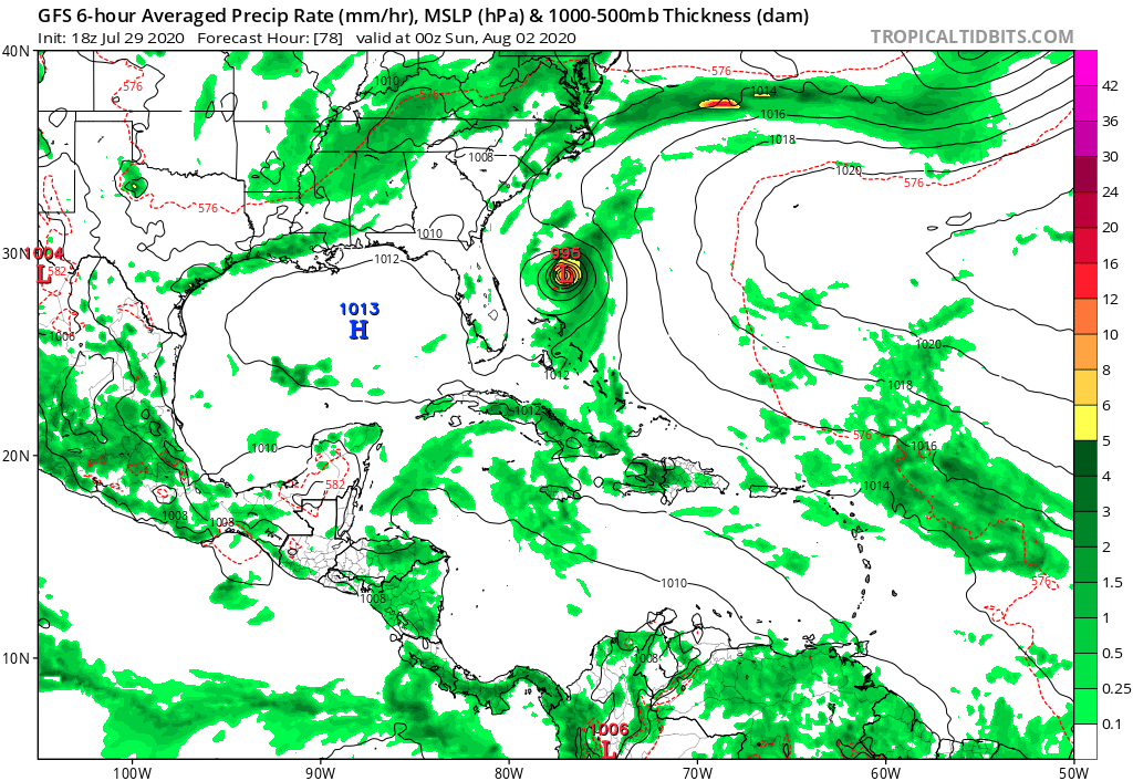
Much stronger on the 18Z GFS as it heads north. Looks like an escape path to miss the US completely. Heading NNE at 78 hours down to 995MB and strengthening:
2 likes
-
Blown Away

- S2K Supporter
- Posts: 10253
- Joined: Wed May 26, 2004 6:17 am
Re: ATL: NINE - Models
18z GFS is has a very sharp right turn after moving out of Bahamas...
0 likes
Hurricane Eye Experience: David 79, Irene 99, Frances 04, Jeanne 04, Wilma 05… Hurricane Brush Experience: Andrew 92, Erin 95, Floyd 99, Matthew 16, Irma 17, Ian 22, Nicole 22…
-
gatorcane
- S2K Supporter
- Posts: 23708
- Age: 48
- Joined: Sun Mar 13, 2005 3:54 pm
- Location: Boca Raton, FL
Re: ATL: NINE - Models
GFS continues to intensify as it heads towards possibly the outer banks of NC. BIG change from the GFS. At 96 hours it is down to 987MB. I think this is the strongest run yet for the GFS.
0 likes
-
TheDreamTraveler

- Category 2

- Posts: 645
- Joined: Sun Aug 22, 2010 3:10 am
- Location: PA
Re: ATL: NINE - Models
NDG wrote:12z EPS is trending towards a deeper trough over the MS rive valley to erode the western end of the narrow ridge to its north when it gets close to FL, but at the same time it keeps trending towards the Bermuda ridge expanding northward to block PTC9 from going OTS.
https://i.imgur.com/o4CcoR1.gif
https://i.imgur.com/7JrvTnW.gif
The ridges have been insane this year. We already saw this with tropical storm fay in early july taking that absurdly weird path straight up the mid atlantic coast and into NJ/NY with no recurve. Normally the homebrew systems off the coast get pushed out to sea once they form. Doesn't surprise me if Isaias goes straight up the coast with how the ridging looks on the models.
1 likes
-
DestinHurricane

- Category 4

- Posts: 935
- Joined: Tue May 01, 2018 8:05 am
- Location: New York, NY
Re: ATL: NINE - Models
gatorcane wrote:GFS continues to intensify as it heads towards possibly the outer banks of NC. BIG change from the GFS. At 96 hours it is down to 987MB. I think this is the strongest run yet for the GFS.
For this to verify it would have to be many miles north of where it is now. The model initializes the storm too far north and because of that it strengthens it and keeps it off the FL coast.
0 likes
Michael 2018
-
gatorcane
- S2K Supporter
- Posts: 23708
- Age: 48
- Joined: Sun Mar 13, 2005 3:54 pm
- Location: Boca Raton, FL
Re: ATL: NINE - Models
18Z GFS has the storm threading the needle between the trough and the ridge, looks to just miss the outer banks. Amazing how these storms can just follow the coast like that but not actually landfall. We have seen this time and time again. That trough looks like something you would see in the fall.
2 likes
-
HurricaneFrances04
- Category 2
- Posts: 597
- Joined: Mon Jun 25, 2012 8:09 am
- Location: Fort Lauderdale, Florida
Re: ATL: NINE - Models
DestinHurricane wrote:gatorcane wrote:GFS continues to intensify as it heads towards possibly the outer banks of NC. BIG change from the GFS. At 96 hours it is down to 987MB. I think this is the strongest run yet for the GFS.
For this to verify it would have to be many miles north of where it is now. The model initializes the storm too far north and because of that it strengthens it and keeps it off the FL coast.
It looks like it has the northern vortex becoming dominant.
0 likes
-
CyclonicFury

- Category 5

- Posts: 2032
- Age: 27
- Joined: Sun Jul 02, 2017 12:32 pm
- Location: NC
- Contact:
Re: ATL: NINE - Models
The trend today has, interestingly, been stronger in the long range.
0 likes
NCSU B.S. in Meteorology Class of 2021. Tropical weather blogger at http://www.cyclonicfury.com. My forecasts and thoughts are NOT official, for official forecasts please consult the National Hurricane Center.
-
gatorcane
- S2K Supporter
- Posts: 23708
- Age: 48
- Joined: Sun Mar 13, 2005 3:54 pm
- Location: Boca Raton, FL
Re: ATL: NINE - Models
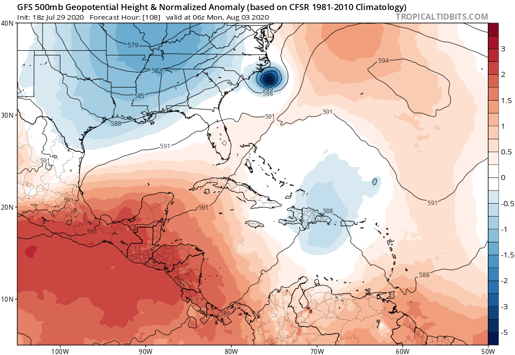
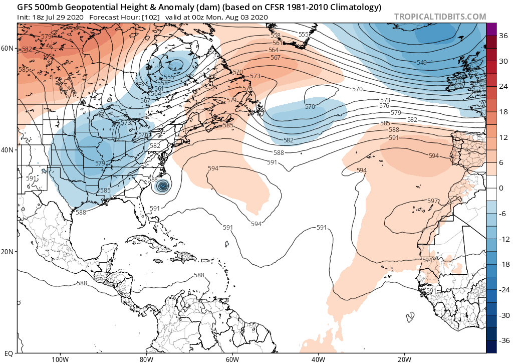
Another look at that anomalously deep trough over the CONUS. Looks how far east it has shoved the Bermuda High. Is it October?!?
1 likes
-
northjaxpro

- S2K Supporter
- Posts: 8900
- Joined: Mon Sep 27, 2010 11:21 am
- Location: Jacksonville, FL
Re: ATL: NINE - Models
***CAUTION****
1. GFS is overdoing the trough, which is notorious for doing quite often
2. Remember, we still do not have a centralized center officially initialized YET. So, until that happens and it is entered into the data, really the models are like throwing darts on a board at this time.
Just my thoughts...
1. GFS is overdoing the trough, which is notorious for doing quite often
2. Remember, we still do not have a centralized center officially initialized YET. So, until that happens and it is entered into the data, really the models are like throwing darts on a board at this time.
Just my thoughts...
7 likes
NEVER, EVER SAY NEVER in the tropics and weather in general, and most importantly, with life itself!!
________________________________________________________________________________________
Fay 2008 Beryl 2012 Debby 2012 Colin 2016 Hermine 2016 Julia 2016 Matthew 2016 Irma 2017 Dorian 2019
________________________________________________________________________________________
Fay 2008 Beryl 2012 Debby 2012 Colin 2016 Hermine 2016 Julia 2016 Matthew 2016 Irma 2017 Dorian 2019
-
DestinHurricane
- Category 4
- Posts: 935
- Joined: Tue May 01, 2018 8:05 am
- Location: New York, NY
Re: ATL: NINE - Models
northjaxpro wrote:***CAUTION****
1. GFS iis overdoing the trough, which is notorious for doing quite often
Edit- you fixed it
0 likes
Michael 2018
-
AutoPenalti
- Category 5
- Posts: 4091
- Age: 29
- Joined: Mon Aug 17, 2015 4:16 pm
- Location: Ft. Lauderdale, Florida
Re: ATL: NINE - Models
northjaxpro wrote:***CAUTION****
1. GFS is overdoing the trough, which is notorious for doing quite often
2. Remember, we still do not have a centralized center officially initialized YET. So, until that happens and it is entered into the data, really the models are like throwing darts on a board at this time.
Just my thoughts...
While that may be true, the Euro seems to be in line with a stronger trough. Not sure how it gets that stronger considering we are in a NAO+ pattern.
0 likes
The posts in this forum are NOT official forecasts and should not be used as such. They are just the opinion of the poster and may or may not be backed by sound meteorological data. They are NOT endorsed by any professional institution or STORM2K. For official information, please refer to products from the NHC and NWS.
Model Runs Cheat Sheet:
GFS (5:30 AM/PM, 11:30 AM/PM)
HWRF, GFDL, UKMET, NAVGEM (6:30-8:00 AM/PM, 12:30-2:00 AM/PM)
ECMWF (1:45 AM/PM)
TCVN is a weighted averaged
-
northjaxpro
- S2K Supporter
- Posts: 8900
- Joined: Mon Sep 27, 2010 11:21 am
- Location: Jacksonville, FL
Re: ATL: NINE - Models
I do not see it going that far east. There will be a narrow ridge in place up the next 48-60 hours, then we will see th e pronounced poleward movement during the weekend. I will eat my hat gladly if it ends up that far east. We will see.
6 likes
NEVER, EVER SAY NEVER in the tropics and weather in general, and most importantly, with life itself!!
________________________________________________________________________________________
Fay 2008 Beryl 2012 Debby 2012 Colin 2016 Hermine 2016 Julia 2016 Matthew 2016 Irma 2017 Dorian 2019
________________________________________________________________________________________
Fay 2008 Beryl 2012 Debby 2012 Colin 2016 Hermine 2016 Julia 2016 Matthew 2016 Irma 2017 Dorian 2019
Re: ATL: NINE - Models
AutoPenalti wrote:northjaxpro wrote:***CAUTION****
1. GFS is overdoing the trough, which is notorious for doing quite often
2. Remember, we still do not have a centralized center officially initialized YET. So, until that happens and it is entered into the data, really the models are like throwing darts on a board at this time.
Just my thoughts...
While that may be true, the Euro seems to be in line with a stronger trough. Not sure how it gets that stronger considering we are in a NAO+ pattern.
Yeah the euro has a strong trough, but not as strong as the GFS..which is why it brings it closer to the SE Florida coast
It’s like Irma redux (except not as strong) where all the models showed the poleward movement but the difference was where. Based on past experience of the GFS overdoing troughs I would say Euro probably has it correct with the trough. I can’t see the trough being that strong as depicted by GFS. JMO
0 likes

Re: ATL: NINE - Models
You can put money down that trough will not be anywhere near that strong. Pattern suggest ridging will win out. This will get a lot closer to home than some think
0 likes
Re: ATL: NINE - Models
HWRF has PTC-9 landfalling in Puerto Rico at an angle and exiting off the northwest tip and then skirting the north coast Hispaniola
HMON goes through Hispaniola and starts to consolidate and intensify once it exits off the north coast
HMON goes through Hispaniola and starts to consolidate and intensify once it exits off the north coast
0 likes
-
HurricaneFrances04
- Category 2
- Posts: 597
- Joined: Mon Jun 25, 2012 8:09 am
- Location: Fort Lauderdale, Florida
-
Aric Dunn
- Category 5
- Posts: 21238
- Age: 43
- Joined: Sun Sep 19, 2004 9:58 pm
- Location: Ready for the Chase.
- Contact:
Re: ATL: NINE - Models
HurricaneFrances04 wrote:Almost all the GFS ensemble members stay off shore Florida
a flag flapping in the wind..
3 likes
Note: If I make a post that is brief. Please refer back to previous posts for the analysis or reasoning. I do not re-write/qoute what my initial post said each time.
If there is nothing before... then just ask
Space & Atmospheric Physicist, Embry-Riddle Aeronautical University,
I believe the sky is falling...
If there is nothing before... then just ask
Space & Atmospheric Physicist, Embry-Riddle Aeronautical University,
I believe the sky is falling...

Re: ATL: NINE - Models
So we should be spared again here in Florida due to the trough which all the models now show.
0 likes
-
Dean4Storms
- S2K Supporter
- Posts: 6358
- Age: 62
- Joined: Sun Aug 31, 2003 1:01 pm
- Location: Miramar Bch. FL
Re: ATL: NINE - Models
LOL....The wiper effect on full speed with the models and no RainX on the windshield. Tomorrow they'll all be back up into the Eastern Gulf or up the Peninsula. They keep jumping this storm more NW and here we are due south now of PR in the Eastern Carib. Sea and still no sign of it.
3 likes
Who is online
Users browsing this forum: No registered users and 48 guests