The HWRF hasn't run since 18z yesterday, at least according to the Tropical Tidbits plots. Anybody know whats going on with that?
The 06z HMON is currently running.
ATL: ISAIAS - Models
Moderator: S2k Moderators
-
AdamFirst

- S2K Supporter

- Posts: 2490
- Age: 36
- Joined: Thu Aug 14, 2008 10:54 am
- Location: Port Saint Lucie, FL
Re: ATL: ISAIAS - Models
0 likes
Dolphins Marlins Canes Golden Panthers HEAT
Andrew 1992 - Irene 1999 - Frances 2004 - Jeanne 2004 - Wilma 2005 - Fay 2008 - Isaac 2012 - Matthew 2016 - Irma 2017 - Dorian 2019 - Ian 2022 - Nicole 2022 - Milton 2024
Andrew 1992 - Irene 1999 - Frances 2004 - Jeanne 2004 - Wilma 2005 - Fay 2008 - Isaac 2012 - Matthew 2016 - Irma 2017 - Dorian 2019 - Ian 2022 - Nicole 2022 - Milton 2024
-
HurricaneFrances04
- Category 2

- Posts: 597
- Joined: Mon Jun 25, 2012 8:09 am
- Location: Fort Lauderdale, Florida
Re: ATL: ISAIAS - Models
The 00Z HWRF is available here - https://storm.aoml.noaa.gov/basin/?projectName=BASIN
0 likes
Re: ATL: ISAIAS - Models
06z HMON is further East than before. Seems like the current trend.
0 likes
-
gatorcane

- S2K Supporter
- Posts: 23708
- Age: 48
- Joined: Sun Mar 13, 2005 3:54 pm
- Location: Boca Raton, FL
Re: ATL: ISAIAS - Models
Looks like little by little, the GFS is going with a stronger 500mb ridge off the SE US coast. I am looking at the 18Z, 00z, and 06Z runs.
5 likes

Re: ATL: ISAIAS - Models
HurricaneFrances04 wrote:Of course it trends weaker and west when "nowcast" shows the storm a little more north
The general trend seems to be a weaker storm will go more west, while a stronger storm will go east of Florida.
Not so much, the latest 06z shifted west because it shows a stronger ridge than previous two runs, but it shows stronger SW shear over it the reason it shows it weaker than previous runs.
1 likes
-
DestinHurricane

- Category 4

- Posts: 935
- Joined: Tue May 01, 2018 8:05 am
- Location: New York, NY
Re: ATL: ISAIAS - Models
gatorcane wrote:Looks like little by little, the GFS is going with a stronger 500mb ridge off the SE US coast. I am looking at the 18Z, 00z, and 06Z runs.
This is why I am not confident that the storm will stay significantly east of FL.
0 likes
Michael 2018
-
gatorcane
- S2K Supporter
- Posts: 23708
- Age: 48
- Joined: Sun Mar 13, 2005 3:54 pm
- Location: Boca Raton, FL
Re: ATL: ISAIAS - Models
GFS ensembles also shifted a bit west. Plenty of time for some more shifts.
3 likes
-
SFLcane

- S2K Supporter
- Posts: 10281
- Age: 48
- Joined: Sat Jun 05, 2010 1:44 pm
- Location: Lake Worth Florida
Re: ATL: ISAIAS - Models
gatorcane wrote:GFS ensembles also shifted a bit west. Plenty of time for some more shifts.
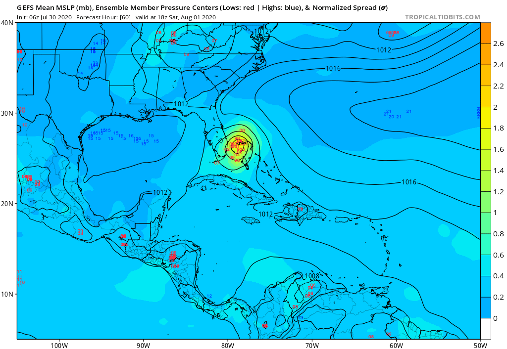
https://i.postimg.cc/yY4XtF8G/gfs-ememb-lowlocs-watl-11.png
Woah!
Last edited by SFLcane on Thu Jul 30, 2020 6:54 am, edited 1 time in total.
0 likes
Re: ATL: ISAIAS - Models
Kat5 wrote:06z HMON is further East than before. Seems like the current trend.
I wouldn't trust HMON past 24-36 hrs. The same model that was forecasting Hanna to make landfall near Port O'Connor a little over two days before landfall while the Euro was already pointing towards S TX.
1 likes
-
Evan_Wilson
- Tropical Low

- Posts: 25
- Joined: Tue May 26, 2020 1:09 pm
Re: ATL: ISAIAS - Models
With this thing skirting through the Mona passage It’d be betting for a stronger storm and a more eastern track.
0 likes
-
jlauderdal
- S2K Supporter
- Posts: 7240
- Joined: Wed May 19, 2004 5:46 am
- Location: NE Fort Lauderdale
- Contact:
Re: RE: Re: ATL: ISAIAS - Models
Nhc has been left of guidance, will continue with that gfs run..upper keys, miami, jupiter, freeport look like good bets for landfallSFLcane wrote:gatorcane wrote:GFS ensembles also shifted a bit west. Plenty of time for some more shifts.
https://i.postimg.cc/yY4XtF8G/gfs-ememb-lowlocs-watl-11.png
Woah!Interesting Gatorcane thx for posting. Might push the tcvn back over FL.
1 likes
-
MJGarrison
- Tropical Storm

- Posts: 146
- Joined: Wed Aug 30, 2017 7:26 pm
Re: ATL: ISAIAS - Models
06Z Euro takes the same track, but just a hair slower.
Sent from my iPad using Tapatalk
Sent from my iPad using Tapatalk
0 likes
-
WeatherEmperor
- S2K Supporter
- Posts: 4806
- Age: 41
- Joined: Thu Sep 04, 2003 2:54 pm
- Location: South Florida
Re: ATL: ISAIAS - Models
MJGarrison wrote:06Z Euro takes the same track, but just a hair slower.
Sent from my iPad using Tapatalk
What intensity is it showing? Stronger or weaker than before?
0 likes

Re: ATL: ISAIAS - Models
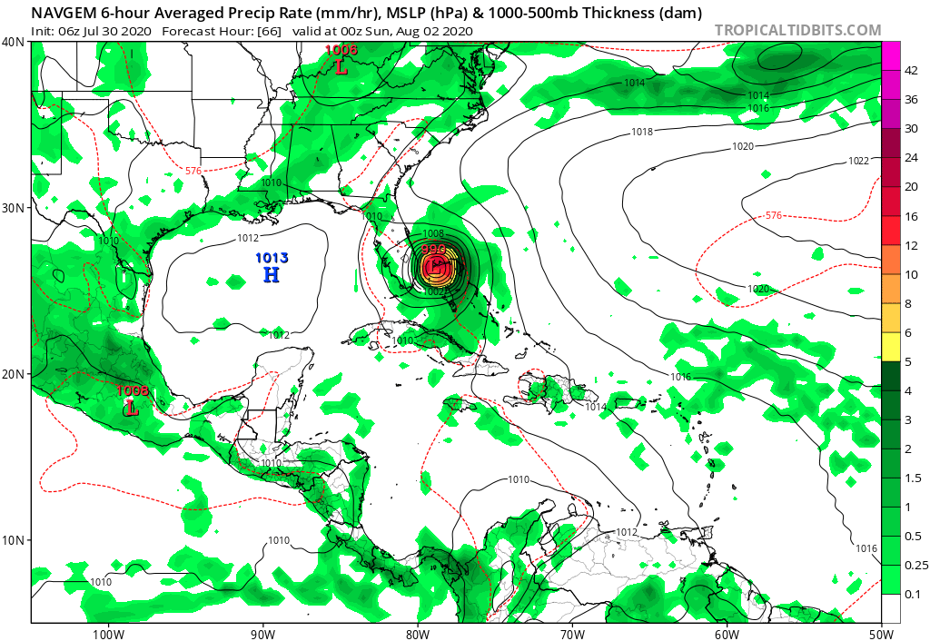
gatorcane wrote:NAVGEM shifts west and is stronger:
https://i.postimg.cc/8cxbp0M8/navgem-mslp-pcpn-watl-11.png
Well this is interesting. Models are slowly showing a stronger ridge than prior runs. The Euro was the first to start sniffing it out several runs ago and it seems that at this moment the rest are picking it up. We shall see what the rest of the day brings
0 likes
Re: ATL: ISAIAS - Models
WeatherEmperor wrote:MJGarrison wrote:06Z Euro takes the same track, but just a hair slower.
Sent from my iPad using Tapatalk
What intensity is it showing? Stronger or weaker than before?
The 06 is WAY weaker, it has an open trough dragging over Cuba with convection to the north then finally wrapping a center before going into Miami as a 1002 TS
0 likes
-
SFLcane
- S2K Supporter
- Posts: 10281
- Age: 48
- Joined: Sat Jun 05, 2010 1:44 pm
- Location: Lake Worth Florida
Re: ATL: ISAIAS - Models
WeatherEmperor wrote:MJGarrison wrote:06Z Euro takes the same track, but just a hair slower.
Sent from my iPad using Tapatalk
What intensity is it showing? Stronger or weaker than before?
About a moderate TS.
0 likes
-
catskillfire51
- S2K Supporter
- Posts: 480
- Age: 39
- Joined: Sun Aug 26, 2012 5:40 pm
- Location: Lake Jackson, TX
Re: ATL: ISAIAS - Models
WeatherEmperor wrote:MJGarrison wrote:06Z Euro takes the same track, but just a hair slower.
Sent from my iPad using Tapatalk
What intensity is it showing? Stronger or weaker than before?
1004MB into the keys it looks, Key Largo specifically.
0 likes
-
northjaxpro

- S2K Supporter
- Posts: 8900
- Joined: Mon Sep 27, 2010 11:21 am
- Location: Jacksonville, FL
Re: ATL: ISAIAS - Models
Just take a good look at the 700 mb steering. The ridge is stout currently extendind west to the Central Gulf.
The ttough is well back yo the west currently and I do not think the trough will deeply amplify like what GFS showed yesterday in its model runs.
I really hope I am wrong and that the GFS is going to send a Fall-like amplified trough to come and get shoved away off the U.S. East Coast. However, I do not see that hsppening fast enough. Isaias likely willl be a major problem for many this weekend. into early next week from Florida north up the U.S. East Coast.
I can not believe the Bahamss is likely going to get heavily impacted by another cyclone so soon after the Dorian catastrophe.
3 likes
NEVER, EVER SAY NEVER in the tropics and weather in general, and most importantly, with life itself!!
________________________________________________________________________________________
Fay 2008 Beryl 2012 Debby 2012 Colin 2016 Hermine 2016 Julia 2016 Matthew 2016 Irma 2017 Dorian 2019
________________________________________________________________________________________
Fay 2008 Beryl 2012 Debby 2012 Colin 2016 Hermine 2016 Julia 2016 Matthew 2016 Irma 2017 Dorian 2019
-
Stangfriik
- Tropical Storm
- Posts: 114
- Joined: Tue Jul 26, 2005 2:25 pm
- Location: Daytona Beach, Florida
- Contact:
Re: ATL: ISAIAS - Models
northjaxpro wrote::uarrow: ahh, there is a reason folks why the latest west shifts in the models are happening.
Just take a good look at the 700 mb steering. The ridge is stout currently extendind west to the Central Gulf.
The ttough is well back yo the west currently and I do not think the trough will deeply amplify like what GFS showed yesterday in its model runs.
I really hope I am wrong and that the GFS is going to send a Fall like amplified trough to come and get shoved away off the U.S. East Coast. However, I do not see that hsppening fast enough. Isaias likely willl be a major problem for many this weekend. into early next week from Florida north up the U.S. East Coast.
I can not believe the Bahamss is likely going to get heavily impacted by another cyclone so soon after the Dorian catasttophe.
Since I'm not the most adept at this, what are the dynamics that will restrict this from strengthening beyond a tropical storm like the nhc map suggests when it'll be riding the gulf stream?
0 likes
Who is online
Users browsing this forum: No registered users and 38 guests