ATL: ISAIAS - Models
Moderator: S2k Moderators
-
SouthFLTropics

- Category 5

- Posts: 4258
- Age: 50
- Joined: Thu Aug 14, 2003 8:04 am
- Location: Port St. Lucie, Florida
Re: ATL: ISAIAS - Models
Something to consider when talking about this angle of approach to Florida and timing. The storm has approximately 52 more hours based on the current forecast track before being in the vicinity of South Florida. IF the storm in real life moves just 1 mile per hour faster than what the models are showing, it could delay the turn by approximately 45 to 50 miles because it will be faster than the trough by that much. A difference of 45 to 50 miles will make a BIG DIFFERENCE.
7 likes
Fourth Generation Florida Native
Personal Storm History: David 79, Andrew 92, Erin 95, Floyd 99, Irene 99, Frances 04, Jeanne 04, Wilma 05, Matthew 16, Irma 17, Ian 22, Nicole 22, Milton 24
Personal Storm History: David 79, Andrew 92, Erin 95, Floyd 99, Irene 99, Frances 04, Jeanne 04, Wilma 05, Matthew 16, Irma 17, Ian 22, Nicole 22, Milton 24
-
Aric Dunn
- Category 5
- Posts: 21238
- Age: 43
- Joined: Sun Sep 19, 2004 9:58 pm
- Location: Ready for the Chase.
- Contact:
Re: ATL: ISAIAS - Models
WeatherEmperor wrote:Arric,
On the image you posted....look right underneath the wind speed legend. It says F012hrs. The image from the other poster has the correct 24hr positions because his says F024hrs
Yeah I made an edit to the post..
0 likes
Note: If I make a post that is brief. Please refer back to previous posts for the analysis or reasoning. I do not re-write/qoute what my initial post said each time.
If there is nothing before... then just ask
Space & Atmospheric Physicist, Embry-Riddle Aeronautical University,
I believe the sky is falling...
If there is nothing before... then just ask
Space & Atmospheric Physicist, Embry-Riddle Aeronautical University,
I believe the sky is falling...
-
SFLcane

- S2K Supporter

- Posts: 10281
- Age: 48
- Joined: Sat Jun 05, 2010 1:44 pm
- Location: Lake Worth Florida
Re: ATL: ISAIAS - Models
SouthFLTropics wrote:Something to consider when talking about this angle of approach to Florida and timing. The storm has approximately 52 more hours based on the current forecast track before being in the vicinity of South Florida. IF the storm in real life moves just 1 mile per hour faster than what the models are showing, it could delay the turn by approximately 45 to 50 miles because it will be faster than the trough by that much. A difference of 45 to 50 miles will make a BIG DIFFERENCE.
I can surely see a hurricane watch for Florida Coast issued tonight. They might wait till recon gets in.
3 likes
-
Hurricaneman

- Category 5
- Posts: 7404
- Age: 45
- Joined: Tue Aug 31, 2004 3:24 pm
- Location: central florida
Re: ATL: ISAIAS - Models
AutoPenalti wrote:If it's faster (iow, LLC is hopping around) it will have a short avenue to move away from the coast. That's something models are not latching onto considering WE HAVE YET TO FIND AN ACTUAL CENTER.
Based on recent Land observations we indeed do have a LLC And it’s stronger than the NHC has so here’s the implications
1. Could become a hurricane sometime tomorrow if trends continue
2. Would end up farther east as it would be stronger
0 likes

Re: ATL: ISAIAS - Models
Aric Dunn wrote:NDG wrote:Aric Dunn wrote:we have a bit of an issue... lol
the 12z Euro 24 hours positions are essentially the current position....
So essentially 18 hours ahead of schedule..
https://i.ibb.co/1nL1ydW/Capture.png
That is not the correct forecast for 24 hrs, the image is for its 12 hr forecast, 0z position this evening.
This is the correct 24 hr position forecast.
https://i.imgur.com/AAHoMC0.png
So there is some bug with the weathernerds site ? I just took a screen shot.
edit : I see the issue. well we can cut that back down to being 4 hours ahead
Yes, it happened to me one time as well, it was mind boggling until figured it out, lol.
1 likes

-
WeatherEmperor
- S2K Supporter
- Posts: 4806
- Age: 41
- Joined: Thu Sep 04, 2003 2:54 pm
- Location: South Florida
Re: ATL: ISAIAS - Models
Aric or somebody, I have a question. The Euro, Ukmet, Euro Ensemble Mean and GFS Ensemble Mean are all to the west of the TVCN. Why is the TVCN so far east if the models I just stated are further west??

Sent from my iPhone using Tapatalk
Sent from my iPhone using Tapatalk
1 likes
-
Ian2401
- Category 1

- Posts: 321
- Joined: Thu Sep 14, 2017 5:55 pm
- Location: Tallahassee, Florida
- Contact:
Re: ATL: ISAIAS - Models
why is everyone talking about forward speed potentially shifting it westward? is it moving faster now?
0 likes
B.S. Meteorology from Florida State '24 // Current M.S. Meteorology student at Florida State
Research Interests: Rapid Intensification, TC Climatology, TC Modeling
Consult the NHC for official information
Research Interests: Rapid Intensification, TC Climatology, TC Modeling
Consult the NHC for official information
-
Camerooski
- Tropical Low

- Posts: 47
- Joined: Wed Aug 08, 2018 5:40 pm
- Location: Lauderdale-By-the-Sea ---> Coral Gables
Re: ATL: ISAIAS - Models
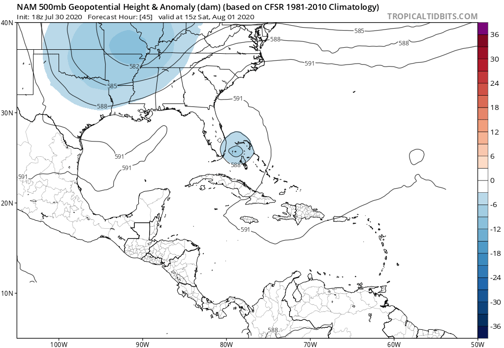
Is the NAM useful for noting trends with the upper atmosphere? i.e. Ridges and troughs?
0 likes
-
Aric Dunn
- Category 5
- Posts: 21238
- Age: 43
- Joined: Sun Sep 19, 2004 9:58 pm
- Location: Ready for the Chase.
- Contact:
Re: ATL: ISAIAS - Models
Ian2401 wrote:why is everyone talking about forward speed potentially shifting it westward? is it moving faster now?
It has not slowed down all too much
0 likes
Note: If I make a post that is brief. Please refer back to previous posts for the analysis or reasoning. I do not re-write/qoute what my initial post said each time.
If there is nothing before... then just ask
Space & Atmospheric Physicist, Embry-Riddle Aeronautical University,
I believe the sky is falling...
If there is nothing before... then just ask
Space & Atmospheric Physicist, Embry-Riddle Aeronautical University,
I believe the sky is falling...
-
HurricaneFrances04
- Category 2

- Posts: 597
- Joined: Mon Jun 25, 2012 8:09 am
- Location: Fort Lauderdale, Florida
-
Aric Dunn
- Category 5
- Posts: 21238
- Age: 43
- Joined: Sun Sep 19, 2004 9:58 pm
- Location: Ready for the Chase.
- Contact:
Re: ATL: ISAIAS - Models
Camerooski wrote:
Is the NAM useful for noting trends with the upper atmosphere? i.e. Ridges and troughs?
That is pretty much all it is useful for the tropics.
the trough over the US is what you should look at the NAM for..
0 likes
Note: If I make a post that is brief. Please refer back to previous posts for the analysis or reasoning. I do not re-write/qoute what my initial post said each time.
If there is nothing before... then just ask
Space & Atmospheric Physicist, Embry-Riddle Aeronautical University,
I believe the sky is falling...
If there is nothing before... then just ask
Space & Atmospheric Physicist, Embry-Riddle Aeronautical University,
I believe the sky is falling...
Re: ATL: ISAIAS - Models
Aric Dunn wrote:Ian2401 wrote:why is everyone talking about forward speed potentially shifting it westward? is it moving faster now?
It has not slowed down all too much
Since it has not slowed, and we're about 4 hours ahead from the plots, that means a bit more west right? (If I've learned that right)
1 likes
Re: ATL: ISAIAS - Models
AutoPenalti wrote:Michele B wrote:sma10 wrote:Also, looks like while Isaias keeps us in suspense crawling up the FL coast, Josephine approaches NE Leewards
Yeah, this is the thing:
Whenever there IS something "out there" to focus on, TWC guys tend to get Soooo focused on THAT, that they never show us the whole Atlantic basin so we can see for ourselves if something is coming down the pike behind it. This is what I find most fascinating...watching how the storms interact off each other when one comes in behind where a previous storm has been. Does the fact that it was just a wave mean nothing? Is the water temp even a degree or two lower? Does that matter? Or are the steering currents SO different by that time that they really do not interact/impact at all? Those are the types of things I find fascinating now. It USED TO BE "just" hurricanes," but after almost 60 years of watching/studying them (as an amateur, or course!), I've started looking at other factors involved in their formation/path/strengthening patterns, etc.
Anyway, it's like they're so thrilled to have a substantial storm to drone on about for 24 hours at a time, that they forget more storms are going to be forming further out!
HELLO?!?!?! It's not even August yet! There's going to be a LOT going on out there! Let us see it!
Well, tbf, Josephine didn't really show up on anyone's radar until today.
When Andrew barreled through, back in '92, I remember ENDLESS HOURS of coverage of the aftermath....
I finally called TWC and said, "HEY!!! It's the "A" storm! There could be something else brewing out there, and all you guys are talking about is Andrew! He's gone. Yes, he did an exorbitant amount of damage, but I'd like you to acknowledge maybe once a day that you are watching to see if anything else is coming our way. We're all very leery, now."
Maybe it was just me being paranoid after Andrew - since I wasn't one of the ones devastated, but watched it very near to us - I just didn't want to be caught unawares.
They seem to just get fixated on just one storm at a time. Drives me nuts sometimes.
0 likes
Cleo - 1964, Betsy - 1965, David - 1979, Andrew - 1992, Charlie (Francis, Ivan, Jeanne) - 2004, Irma - 2017, Ian - 2022, Milton - 2024
-
jlauderdal
- S2K Supporter
- Posts: 7240
- Joined: Wed May 19, 2004 5:46 am
- Location: NE Fort Lauderdale
- Contact:
Re: ATL: ISAIAS - Models
there is a trough moving in from the west which will steer it so if the system moves quicker than it can hit the united states before the tough moves in...if there was no trough it would keep heading wnwIan2401 wrote:why is everyone talking about forward speed potentially shifting it westward? is it moving faster now?
0 likes
-
Aric Dunn
- Category 5
- Posts: 21238
- Age: 43
- Joined: Sun Sep 19, 2004 9:58 pm
- Location: Ready for the Chase.
- Contact:
Re: ATL: ISAIAS - Models
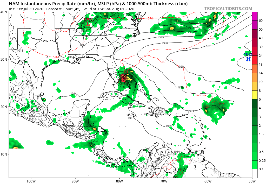
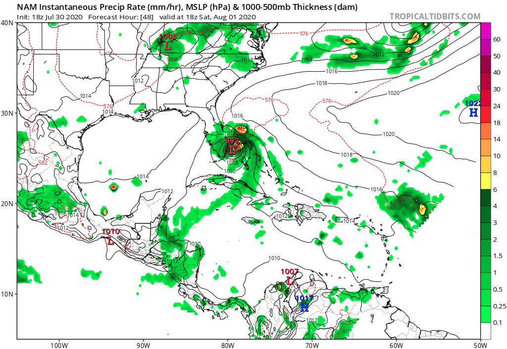
THE NAM slightly east because the Low/trough over Kentucky is faster and farther east.
0 likes
Note: If I make a post that is brief. Please refer back to previous posts for the analysis or reasoning. I do not re-write/qoute what my initial post said each time.
If there is nothing before... then just ask
Space & Atmospheric Physicist, Embry-Riddle Aeronautical University,
I believe the sky is falling...
If there is nothing before... then just ask
Space & Atmospheric Physicist, Embry-Riddle Aeronautical University,
I believe the sky is falling...
-
cp79
Re: ATL: ISAIAS - Models
Lance wrote:Aric Dunn wrote:Ian2401 wrote:why is everyone talking about forward speed potentially shifting it westward? is it moving faster now?
It has not slowed down all too much
Since it has not slowed, and we're about 4 hours ahead from the plots, that means a bit more west right? (If I've learned that right)
It should. The GFS starts running in an hour and will be interesting to see how they play the fast speed.
0 likes
-
OuterBanker
- S2K Supporter
- Posts: 1761
- Joined: Wed Feb 26, 2003 10:53 am
- Location: Nags Head, NC
- Contact:
Re: ATL: ISAIAS - Models
WeatherEmperor wrote:Aric or somebody, I have a question. The Euro, Ukmet, Euro Ensemble Mean and GFS Ensemble Mean are all to the west of the TVCN. Why is the TVCN so far east if the models I just stated are further west??
https://uploads.tapatalk-cdn.com/20200730/fd90b7445b7f0a3bacd1a3e20e51a17f.gif
Whoa, those tracks do have various scenarios for Florida. But, the consensus for eastern North Carolina is not good.
Sent from my iPhone using Tapatalk
0 likes
-
Ian2401
- Category 1
- Posts: 321
- Joined: Thu Sep 14, 2017 5:55 pm
- Location: Tallahassee, Florida
- Contact:
Re: ATL: ISAIAS - Models
jlauderdal wrote:there is a trough moving in from the west which will steer it so if the system moves quicker than it can hit the united states before the tough moves in...if there was no trough it would keep heading wnwIan2401 wrote:why is everyone talking about forward speed potentially shifting it westward? is it moving faster now?
no i know, im asking if it is going faster than expected now?
0 likes
B.S. Meteorology from Florida State '24 // Current M.S. Meteorology student at Florida State
Research Interests: Rapid Intensification, TC Climatology, TC Modeling
Consult the NHC for official information
Research Interests: Rapid Intensification, TC Climatology, TC Modeling
Consult the NHC for official information
Who is online
Users browsing this forum: No registered users and 29 guests