ATL: ISAIAS - Models

Moderator: S2k Moderators

Message
Author
SapphireSea
Category 1
Category 1
Posts: 430
Joined: Wed Aug 24, 2005 12:13 pm
Location: Miami, FL

Re: ATL: ISAIAS - Models

#1761 Postby SapphireSea » Thu Jul 30, 2020 9:12 pm

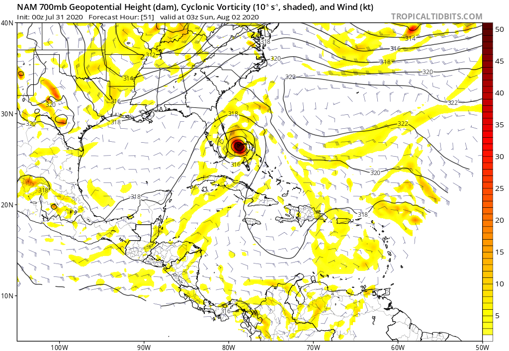
SFLcane wrote:Nam coming in way south.. hmm

I know it’s the nam. :roll:


It's south, but more because it's slowing down. Looks like it may end up east in the end.
0 likes   

User avatar
toad strangler
S2K Supporter
S2K Supporter
Posts: 4543
Joined: Sun Jul 28, 2013 3:09 pm
Location: Earth
Contact:

Re: ATL: ISAIAS - Models

#1762 Postby toad strangler » Thu Jul 30, 2020 9:14 pm

HurricaneFrances04 wrote:Looks east to me


Agree. It's East
0 likes   

User avatar
SFLcane
S2K Supporter
S2K Supporter
Posts: 10163
Age: 47
Joined: Sat Jun 05, 2010 1:44 pm
Location: Lake Worth Florida

Re: ATL: ISAIAS - Models

#1763 Postby SFLcane » Thu Jul 30, 2020 9:18 pm

Not a good trend! @cyclonicwx

Not liking this trend in the short term of #Isaias's forecast, trough may dig a little more, but this results in a more amplified pattern that strengthens the ridge downstream (over Isaias). May be able to go further west, & a slower trough trend means later recurve.

https://twitter.com/cyclonicwx/status/1 ... 53312?s=21
0 likes   

Ken711
Category 5
Category 5
Posts: 1074
Joined: Tue Aug 28, 2012 12:48 pm

Re: ATL: ISAIAS - Models

#1764 Postby Ken711 » Thu Jul 30, 2020 9:22 pm

PTrackerLA wrote:18z Euro ensemble tracks, this could be a big deal for Eastern NC, the Mid-Atlantic and especially the Northeast who aren't too used to sub 970mb hurricanes racing through...

https://i.imgur.com/gtnA3EU.png


OTB for sure with those 18Z ensemble tracks.
0 likes   

AxaltaRacing24
Category 5
Category 5
Posts: 1753
Age: 25
Joined: Wed Jul 27, 2016 11:14 am
Location: Jupiter, FL

Re: ATL: ISAIAS - Models

#1765 Postby AxaltaRacing24 » Thu Jul 30, 2020 9:22 pm

toad strangler wrote:
HurricaneFrances04 wrote:Looks east to me


Agree. It's East

it's an east shift due to the slower speed.
0 likes   

User avatar
gatorcane
S2K Supporter
S2K Supporter
Posts: 23691
Age: 47
Joined: Sun Mar 13, 2005 3:54 pm
Location: Boca Raton, FL

Re: ATL: ISAIAS - Models

#1766 Postby gatorcane » Thu Jul 30, 2020 9:24 pm

toad strangler wrote:
HurricaneFrances04 wrote:Looks east to me


Agree. It's East


Yes ends up a bit east but I see more ridging still compared to 18Z, maybe because it moves the storm a bit slower. Talk about threading the needle just barely misses Palm Beach:

Image
0 likes   

User avatar
PTrackerLA
Category 5
Category 5
Posts: 5277
Age: 41
Joined: Thu Oct 10, 2002 8:40 pm
Location: Lafayette, LA

Re: ATL: ISAIAS - Models

#1767 Postby PTrackerLA » Thu Jul 30, 2020 9:28 pm

00z 3km NAM down to 956mb at 42 hours, strongest run yet of I know it's the NAM.

Image
2 likes   

shah83
Category 1
Category 1
Posts: 302
Joined: Sun Jul 31, 2016 4:55 pm

Re: ATL: ISAIAS - Models

#1768 Postby shah83 » Thu Jul 30, 2020 9:34 pm

I'm mostly looking at the ridge. Stouter? Thicker? More likely for a NNE recurve that hits points further north?
0 likes   

User avatar
Hybridstorm_November2001
S2K Supporter
S2K Supporter
Posts: 2811
Joined: Sat Aug 21, 2004 2:50 pm
Location: SW New Brunswick, Canada
Contact:

Re: ATL: ISAIAS - Models

#1769 Postby Hybridstorm_November2001 » Thu Jul 30, 2020 9:35 pm

I can't help but wonder given recent runs if the trough will "juice up" Isaias due to its baroclinic influence. :double:
0 likes   

User avatar
SouthFLTropics
Category 5
Category 5
Posts: 4236
Age: 50
Joined: Thu Aug 14, 2003 8:04 am
Location: Port St. Lucie, Florida

Re: ATL: ISAIAS - Models

#1770 Postby SouthFLTropics » Thu Jul 30, 2020 10:18 pm

For what it's worth, ICON is SW of the 18z position.

Image
0 likes   
Fourth Generation Florida Native

Personal Storm History: David 79, Andrew 92, Erin 95, Floyd 99, Irene 99, Frances 04, Jeanne 04, Wilma 05, Matthew 16, Irma 17, Ian 22, Nicole 22, Milton 24

caneseddy
Category 5
Category 5
Posts: 1172
Joined: Fri Sep 03, 2004 9:31 pm
Location: Plantation, FL

Re: ATL: ISAIAS - Models

#1771 Postby caneseddy » Thu Jul 30, 2020 10:47 pm

GFS still tracks it offshore and looks like almost no change from the 18z run out to 48 hours. Has it more strong and moving faster. Looks like it will end up brushing the OBX
Last edited by caneseddy on Thu Jul 30, 2020 10:57 pm, edited 1 time in total.
0 likes   

User avatar
Hurricaneman
Category 5
Category 5
Posts: 7351
Age: 45
Joined: Tue Aug 31, 2004 3:24 pm
Location: central florida

Re: ATL: ISAIAS - Models

#1772 Postby Hurricaneman » Thu Jul 30, 2020 10:51 pm

SouthFLTropics wrote:For what it's worth, ICON is SW of the 18z position.

https://i.imgur.com/WmRI7hQ.gif


Earlier in the run it’s too weak compared to reality
0 likes   

User avatar
SoupBone
Category 5
Category 5
Posts: 3111
Joined: Tue Sep 20, 2005 5:24 pm

Re: ATL: ISAIAS - Models

#1773 Postby SoupBone » Thu Jul 30, 2020 10:53 pm

GFS very close to identical to its previous run, just far enough offshore to have less impacts on Florida. This is really threading a needle.
2 likes   
Personal Forecast Disclaimer:
The posts in this forum are NOT official forecast and should not be used as such. They are just the opinion of the poster and may or may not be backed by sound meteorological data. They are NOT endorsed by any professional institution or storm2k.org. For official information, please refer to the NHC and NWS products.

supercane4867
Category 5
Category 5
Posts: 4966
Joined: Wed Nov 14, 2012 10:43 am

Re: ATL: ISAIAS - Models

#1774 Postby supercane4867 » Thu Jul 30, 2020 11:03 pm

00z GFS shows major NE impact. Also has a stronger Josephine behind Isaias.
0 likes   

User avatar
TheDreamTraveler
Category 2
Category 2
Posts: 641
Joined: Sun Aug 22, 2010 3:10 am
Location: PA

Re: ATL: ISAIAS - Models

#1775 Postby TheDreamTraveler » Thu Jul 30, 2020 11:05 pm

0z gfs shows it skirting by Florida, a North Carolina landfall, riding up the mid atlantic coast and landfalling in NY/New England
Last edited by TheDreamTraveler on Thu Jul 30, 2020 11:06 pm, edited 1 time in total.
0 likes   

User avatar
Ubuntwo
Category 5
Category 5
Posts: 1406
Age: 31
Joined: Thu Oct 05, 2017 10:41 pm

Re: ATL: ISAIAS - Models

#1776 Postby Ubuntwo » Thu Jul 30, 2020 11:05 pm

Image
0z GFS sends a hurricane into Long Island.
0 likes   
Kendall -> SLO -> PBC

Memorable Storms: Katrina (for its Florida landfall...) Wilma Matthew Irma

supercane4867
Category 5
Category 5
Posts: 4966
Joined: Wed Nov 14, 2012 10:43 am

Re: ATL: ISAIAS - Models

#1777 Postby supercane4867 » Thu Jul 30, 2020 11:08 pm

Well, perhaps the shear is not as strong as we thought.

Image
0 likes   

User avatar
TheDreamTraveler
Category 2
Category 2
Posts: 641
Joined: Sun Aug 22, 2010 3:10 am
Location: PA

Re: ATL: ISAIAS - Models

#1778 Postby TheDreamTraveler » Thu Jul 30, 2020 11:09 pm

Also shows it landfalling in Maine

Image
0 likes   

User avatar
Hybridstorm_November2001
S2K Supporter
S2K Supporter
Posts: 2811
Joined: Sat Aug 21, 2004 2:50 pm
Location: SW New Brunswick, Canada
Contact:

Re: ATL: ISAIAS - Models

#1779 Postby Hybridstorm_November2001 » Thu Jul 30, 2020 11:11 pm

Ubuntwo wrote:0z GFS sends a hurricane into Long Island.


The senario literally no one wants given the crap NYC/Long Island has already been through this year. :grr: :eek:
3 likes   

User avatar
Hurricaneman
Category 5
Category 5
Posts: 7351
Age: 45
Joined: Tue Aug 31, 2004 3:24 pm
Location: central florida

Re: ATL: ISAIAS - Models

#1780 Postby Hurricaneman » Thu Jul 30, 2020 11:11 pm

Looks like a similar path to Carol in 1954 on the GFS, something I didn’t think I would say in Late July, Early August
0 likes   


Return to “2020”

Who is online

Users browsing this forum: No registered users and 11 guests