ATL: ISAIAS - Models
Moderator: S2k Moderators
Re: ATL: ISAIAS - Models
Be careful when you say weak. Shear isn't bad. If it slows down it may intensify more than forecast. Currently outrunning the convection but it is expected to slow down it's forward speed.
The posts in this forum are NOT official forecasts and should not be used as such. They are just the opinion of the poster and may or may not be backed by sound meteorological data. They are NOT endorsed by any professional institution or STORM2K. For official information, please refer to products from the NHC and NWS.
0 likes
- northjaxpro
- S2K Supporter

- Posts: 8900
- Joined: Mon Sep 27, 2010 11:21 am
- Location: Jacksonville, FL
Re: ATL: ISAIAS - Models
Jr0d wrote:tarheelprogrammer wrote:Most models are keeping this weak, or relatively weak. This is why it landfalls in FL. Again, it will be rough but nothing along the lines of catastrophic for FL. No rain issues and most of FL stays on the west side of a weak TS. Models see a bad environment around this system.
I am not sold on that. More ridging usually means more favorable conditions. Also if the models got the ridging wrong, why be confident in their shear
EURO has had the ridging from the beginning.
0 likes
NEVER, EVER SAY NEVER in the tropics and weather in general, and most importantly, with life itself!!
________________________________________________________________________________________
Fay 2008 Beryl 2012 Debby 2012 Colin 2016 Hermine 2016 Julia 2016 Matthew 2016 Irma 2017 Dorian 2019
________________________________________________________________________________________
Fay 2008 Beryl 2012 Debby 2012 Colin 2016 Hermine 2016 Julia 2016 Matthew 2016 Irma 2017 Dorian 2019
Re: ATL: ISAIAS - Models
Steve H. wrote:Be careful when you say weak. Shear isn't bad. If it slows down it may intensify more than forecast. Currently outrunning the convection but it is expected to slow down it's forward speed.The posts in this forum are NOT official forecasts and should not be used as such. They are just the opinion of the poster and may or may not be backed by sound meteorological data. They are NOT endorsed by any professional institution or STORM2K. For official information, please refer to products from the NHC and NWS.
Another important note - even the weak models suggest strengthening once the system turns north. If the system takes a slightly inland route as suggested by the new UK, don't make an assumption that Isaias will fall apart due to land. There is a history of dynamically strengthening systems not being affected at all passing over the Everglades
0 likes
Re: ATL: ISAIAS - Models
12z UKMET:
HURRICANE ISAIAS ANALYSED POSITION : 21.6N 73.9W
ATCF IDENTIFIER : AL092020
LEAD CENTRAL MAXIMUM WIND
VERIFYING TIME TIME POSITION PRESSURE (MB) SPEED (KNOTS)
-------------- ---- -------- ------------- -------------
1200UTC 31.07.2020 0 21.6N 73.9W 1003 46
0000UTC 01.08.2020 12 23.0N 76.7W 1001 46
1200UTC 01.08.2020 24 24.1N 78.7W 1001 40
0000UTC 02.08.2020 36 25.0N 79.9W 1001 42
1200UTC 02.08.2020 48 25.9N 80.8W 1004 30
0000UTC 03.08.2020 60 27.0N 81.3W 1004 30
1200UTC 03.08.2020 72 28.3N 81.7W 1007 30
0000UTC 04.08.2020 84 30.2N 81.1W 1002 40
1200UTC 04.08.2020 96 32.7N 79.9W 989 55
0000UTC 05.08.2020 108 36.5N 78.0W 987 36
1200UTC 05.08.2020 120 40.9N 75.0W 990 48
0000UTC 06.08.2020 132 46.5N 70.3W 990 30
1200UTC 06.08.2020 144 CEASED TRACKING
0 likes
The posts in this forum are NOT official forecast and should not be used as such. They are just the opinion of the poster and may or may not be backed by sound meteorological data. They are NOT endorsed by any professional institution or STORM2K. For official information, refer to products from the National Hurricane Center and National Weather Service.
-
Aric Dunn
- Category 5

- Posts: 21238
- Age: 43
- Joined: Sun Sep 19, 2004 9:58 pm
- Location: Ready for the Chase.
- Contact:
Re: ATL: ISAIAS - Models
CMC almost gets left behind.
0 likes
Note: If I make a post that is brief. Please refer back to previous posts for the analysis or reasoning. I do not re-write/qoute what my initial post said each time.
If there is nothing before... then just ask
Space & Atmospheric Physicist, Embry-Riddle Aeronautical University,
I believe the sky is falling...
If there is nothing before... then just ask
Space & Atmospheric Physicist, Embry-Riddle Aeronautical University,
I believe the sky is falling...
Re: ATL: ISAIAS - Models
WxEp wrote:12z UKMET:
HURRICANE ISAIAS ANALYSED POSITION : 21.6N 73.9W
ATCF IDENTIFIER : AL092020
LEAD CENTRAL MAXIMUM WIND
VERIFYING TIME TIME POSITION PRESSURE (MB) SPEED (KNOTS)
-------------- ---- -------- ------------- -------------
1200UTC 31.07.2020 0 21.6N 73.9W 1003 46
0000UTC 01.08.2020 12 23.0N 76.7W 1001 46
1200UTC 01.08.2020 24 24.1N 78.7W 1001 40
0000UTC 02.08.2020 36 25.0N 79.9W 1001 42
1200UTC 02.08.2020 48 25.9N 80.8W 1004 30
0000UTC 03.08.2020 60 27.0N 81.3W 1004 30
1200UTC 03.08.2020 72 28.3N 81.7W 1007 30
0000UTC 04.08.2020 84 30.2N 81.1W 1002 40
1200UTC 04.08.2020 96 32.7N 79.9W 989 55
0000UTC 05.08.2020 108 36.5N 78.0W 987 36
1200UTC 05.08.2020 120 40.9N 75.0W 990 48
0000UTC 06.08.2020 132 46.5N 70.3W 990 30
1200UTC 06.08.2020 144 CEASED TRACKING
That would be a not so fun windy rainmaker for most of the state. Add in the ridging and trough, ripe conditions for tornadoes.
0 likes
Re: ATL: ISAIAS - Models
Everyone in watch and warning areas, do remember the models never forecast Hanna to become a hurricane, so keep that in your mind. They had also failed to predict Isaias would be a hurricane shortly after coming off Hispaniola. Prepare for the worst, hope for the best.
Last edited by artist on Fri Jul 31, 2020 11:44 am, edited 3 times in total.
3 likes
- Blown Away
- S2K Supporter

- Posts: 10253
- Joined: Wed May 26, 2004 6:17 am
Re: ATL: ISAIAS - Models
chris_fit wrote:Has anything trended EAST in the last 24 hours?
No pretty substantial W shift only.
1 likes
Hurricane Eye Experience: David 79, Irene 99, Frances 04, Jeanne 04, Wilma 05… Hurricane Brush Experience: Andrew 92, Erin 95, Floyd 99, Matthew 16, Irma 17, Ian 22, Nicole 22…
- SFLcane
- S2K Supporter

- Posts: 10281
- Age: 48
- Joined: Sat Jun 05, 2010 1:44 pm
- Location: Lake Worth Florida
Re: ATL: ISAIAS - Models
Fully expect another west shift on NHC track at 5. Euro will be key
1 likes
-
AutoPenalti
- Category 5

- Posts: 4091
- Age: 29
- Joined: Mon Aug 17, 2015 4:16 pm
- Location: Ft. Lauderdale, Florida
Re: ATL: ISAIAS - Models
chris_fit wrote:Has anything trended EAST in the last 24 hours?
I think NAM is the only one.
0 likes
The posts in this forum are NOT official forecasts and should not be used as such. They are just the opinion of the poster and may or may not be backed by sound meteorological data. They are NOT endorsed by any professional institution or STORM2K. For official information, please refer to products from the NHC and NWS.
Model Runs Cheat Sheet:
GFS (5:30 AM/PM, 11:30 AM/PM)
HWRF, GFDL, UKMET, NAVGEM (6:30-8:00 AM/PM, 12:30-2:00 AM/PM)
ECMWF (1:45 AM/PM)
TCVN is a weighted averaged
- SouthFLTropics
- Category 5

- Posts: 4258
- Age: 50
- Joined: Thu Aug 14, 2003 8:04 am
- Location: Port St. Lucie, Florida
Re: ATL: ISAIAS - Models
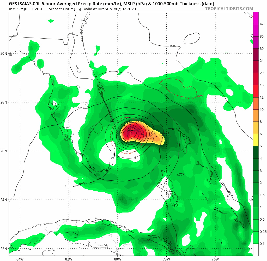
HWRF Para coming in SW of the 06z and slightly stronger... FWIW, the HWRF and HMON are SW of 06z also.


0 likes
Fourth Generation Florida Native
Personal Storm History: David 79, Andrew 92, Erin 95, Floyd 99, Irene 99, Frances 04, Jeanne 04, Wilma 05, Matthew 16, Irma 17, Ian 22, Nicole 22, Milton 24
Personal Storm History: David 79, Andrew 92, Erin 95, Floyd 99, Irene 99, Frances 04, Jeanne 04, Wilma 05, Matthew 16, Irma 17, Ian 22, Nicole 22, Milton 24
-
HurricaneFrances04
- Category 2

- Posts: 597
- Joined: Mon Jun 25, 2012 8:09 am
- Location: Fort Lauderdale, Florida
Re: ATL: ISAIAS - Models
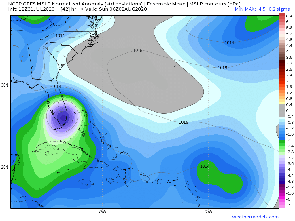
GFS ensembles are SW as well. Pretty much in line with the 6z Euro.
0 likes
-
WeatherEmperor
- S2K Supporter

- Posts: 4806
- Age: 41
- Joined: Thu Sep 04, 2003 2:54 pm
- Location: South Florida
Re: ATL: ISAIAS - Models
HurricaneFrances04 wrote:GFS ensembles are SW as well. Pretty much in line with the 6z Euro.
What is the intensity look like? Are they weaker or stronger?
0 likes
-
HurricaneFrances04
- Category 2

- Posts: 597
- Joined: Mon Jun 25, 2012 8:09 am
- Location: Fort Lauderdale, Florida
Re: ATL: ISAIAS - Models
WeatherEmperor wrote:HurricaneFrances04 wrote:GFS ensembles are SW as well. Pretty much in line with the 6z Euro.
What is the intensity look like? Are they weaker or stronger?
A few of the members are maybe 3 or 4 mb stronger than the 6z.
0 likes
-
TheStormExpert
-
Hd444
Re: ATL: ISAIAS - Models
Just a friendly reminder of how right biased the HWRF is with Isaias.


1 likes
Who is online
Users browsing this forum: No registered users and 49 guests


