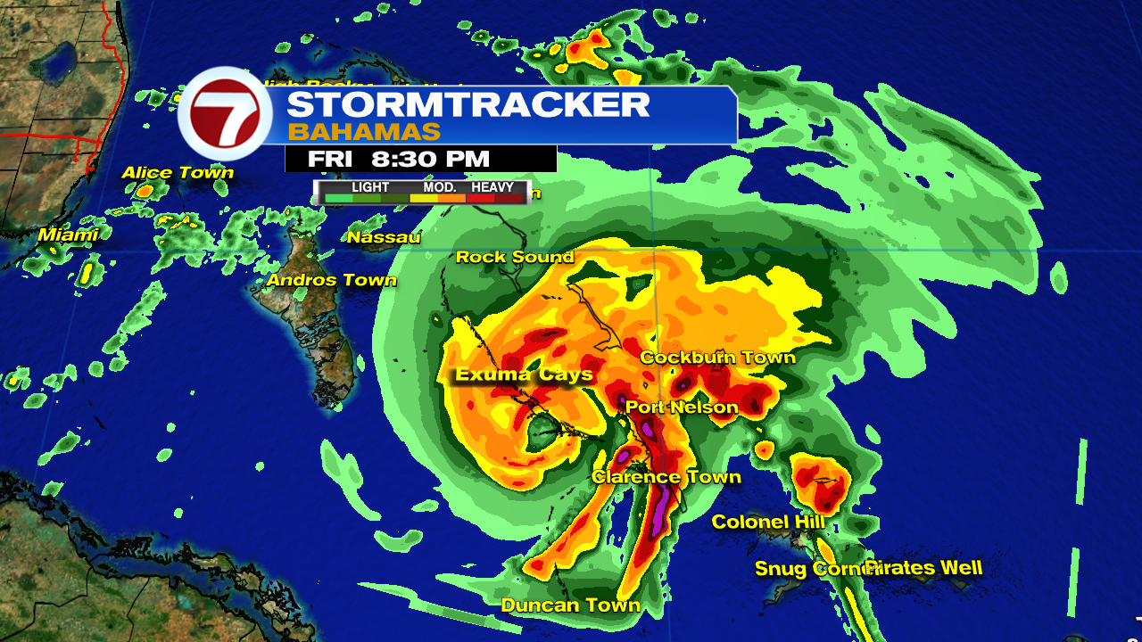
ATL: ISAIAS - Post-Tropical - Discussion

Moderator: S2k Moderators

Message
Author
wx98
Category 5
Category 5
Posts: 1383
Joined: Sat Aug 25, 2018 9:24 pm

Re: ATL: ISAIAS - Hurricane - Discussion

#3441 Postby wx98 » Fri Jul 31, 2020 7:41 pm

aspen wrote:
wx98 wrote:MSLP data is nutty on the NOAA plane. Useless...

Based on the even steeper wind drop than the previous pass, I think the pressure might be lower. We’ll have to see what the second plane finds in 15-30 minutes.

I agree. It could be down 2-3 mb possibly.
0 likes   

User avatar
cheezyWXguy
Category 5
Category 5
Posts: 6108
Joined: Mon Feb 13, 2006 12:29 am
Location: Dallas, TX

Re: ATL: ISAIAS - Hurricane - Discussion

#3442 Postby cheezyWXguy » Fri Jul 31, 2020 7:42 pm

WilmingtonSandbar wrote:I have been away from the computer most of the afternoon, so someone probably talked about this earlier. Why does Isaias constantly have the blow up of convection on the west side? Is there a competing vort under that?

If you mean the east side, no there isn’t a competing vort but it is competing for energy and this can slow the rate of intensification. Fairly common in low end northward moving hurricanes, I recall Michael looked like this as it passed Cuba.
2 likes   

ozonepete
Professional-Met
Professional-Met
Posts: 4743
Joined: Mon Sep 07, 2009 3:23 pm
Location: From Ozone Park, NYC / Now in Brooklyn, NY

Re: ATL: ISAIAS - Hurricane - Discussion

#3443 Postby ozonepete » Fri Jul 31, 2020 7:43 pm

Don't know exactly what's going on, but the symmetry is awful. No decent CDO at all right now and it's stretched from north to south.
5 likes   

User avatar
aspen
Category 5
Category 5
Posts: 8818
Joined: Sat Oct 12, 2019 7:10 pm
Location: Connecticut, USA

Re: ATL: ISAIAS - Hurricane - Discussion

#3444 Postby aspen » Fri Jul 31, 2020 7:45 pm

ozonepete wrote:Don't know exactly what's going on, but the symmetry is awful. No decent CDO at all right now and it's stretched from north to south.

It kind of looks like it’s still wrapping around a bit. That, or a bit of dry air nibbled the right side of the CDO.
1 likes   
Irene '11 Sandy '12 Hermine '16 5/15/2018 Derecho Fay '20 Isaias '20 Elsa '21 Henri '21 Ida '21

I am only a meteorology enthusiast who knows a decent amount about tropical cyclones. Look to the professional mets, the NHC, or your local weather office for the best information.

User avatar
KWT
Category 5
Category 5
Posts: 31415
Joined: Tue Aug 17, 2004 11:02 am
Location: UK!!!

Re: ATL: ISAIAS - Hurricane - Discussion

#3445 Postby KWT » Fri Jul 31, 2020 7:47 pm

ozonepete wrote:Don't know exactly what's going on, but the symmetry is awful. No decent CDO at all right now and it's stretched from north to south.


Yet inner core looked solid on radar and recon shows a closed eyewall.

Whatever is happening elsewhere is not disrupting the core yet.

It may just be one of those canes that never becomes a looker. I've seen some really poor looking 65-85kts canes in my time, this far from the worst.
7 likes   
Personal Forecast Disclaimer:
The posts in this forum are NOT official forecast and should not be used as such. They are just the opinion of the poster and may or may not be backed by sound meteorological data. They are NOT endorsed by any professional institution or storm2k.org. For official information, please refer to the NHC and NWS products

User avatar
chaser1
S2K Supporter
S2K Supporter
Posts: 5472
Age: 64
Joined: Sat Oct 15, 2005 5:59 pm
Location: Longwood, Fl

Re: ATL: ISAIAS - Hurricane - Discussion

#3446 Postby chaser1 » Fri Jul 31, 2020 7:48 pm

WilmingtonSandbar wrote:I have been away from the computer most of the afternoon, so someone probably talked about this earlier. Why does Isaias constantly have the blow up of convection on the west side? Is there a competing vort under that?


You mean East Side. Left side is the actual CDO (and COC). Good question though and I have no really good answer. One wouldn't think that a fairly deep hurricane would have a secondary mid level feature tethered to it. Often times a hurricane will have a vorticity max near it's core that will rotate around the eye. This other..... appendage? It's not rotating around the storm, and oddly it's not being absorbed "like a feeder band " into the storms structure. In fact, this stupid blob seems to have wrestled away the one true feeder band that was actually feeding into Isaias from the south.
5 likes   
Andy D

(For official information, please refer to the NHC and NWS products.)

AxaltaRacing24
Category 5
Category 5
Posts: 1753
Age: 25
Joined: Wed Jul 27, 2016 11:14 am
Location: Jupiter, FL

Re: ATL: ISAIAS - Hurricane - Discussion

#3447 Postby AxaltaRacing24 » Fri Jul 31, 2020 7:50 pm

KWT wrote:
ozonepete wrote:Don't know exactly what's going on, but the symmetry is awful. No decent CDO at all right now and it's stretched from north to south.


Yet inner core looked solid on radar and recon shows a closed eyewall.

Whatever is happening elsewhere is not disrupting the core yet.

It may just be one of those canes that never becomes a looker. I've seen some really poor looking 65-85kts canes in my time, this far from the worst.

is this where we mention "hurricane" barry?
3 likes   

User avatar
northjaxpro
S2K Supporter
S2K Supporter
Posts: 8900
Joined: Mon Sep 27, 2010 11:21 am
Location: Jacksonville, FL

Re: ATL: ISAIAS - Hurricane - Discussion

#3448 Postby northjaxpro » Fri Jul 31, 2020 7:51 pm

ozonepete wrote:Don't know exactly what's going on, but the symmetry is awful. No decent CDO at all right now and it's stretched from north to south.


Good Evening Pete!
1 likes   
NEVER, EVER SAY NEVER in the tropics and weather in general, and most importantly, with life itself!!

________________________________________________________________________________________

Fay 2008 Beryl 2012 Debby 2012 Colin 2016 Hermine 2016 Julia 2016 Matthew 2016 Irma 2017 Dorian 2019

User avatar
cheezyWXguy
Category 5
Category 5
Posts: 6108
Joined: Mon Feb 13, 2006 12:29 am
Location: Dallas, TX

Re: ATL: ISAIAS - Hurricane - Discussion

#3449 Postby cheezyWXguy » Fri Jul 31, 2020 7:52 pm

ozonepete wrote:Don't know exactly what's going on, but the symmetry is awful. No decent CDO at all right now and it's stretched from north to south.


Haha I mean, it’s not great but it looks better than it did this morning. Didn’t you say this looked like it was on its way to being a strong hurricane a few pages back, or am I quoting someone else?
1 likes   

User avatar
Weatherboy1
Category 5
Category 5
Posts: 1189
Age: 49
Joined: Mon Jul 05, 2004 1:50 pm
Location: Jupiter/Sarasota, FL

Re: ATL: ISAIAS - Hurricane - Discussion

#3450 Postby Weatherboy1 » Fri Jul 31, 2020 7:53 pm

Is it just me or is there a bit more high level outflow/“feathering” of the clouds to the west of the CDO. Not sure if that will help with development but seems like a new trend over last hour or so
1 likes   

User avatar
HurricaneEnzo
Category 2
Category 2
Posts: 739
Joined: Wed Mar 14, 2018 12:18 pm
Location: Newport, NC (Hurricane Alley)

Re: ATL: ISAIAS - Hurricane - Discussion

#3451 Postby HurricaneEnzo » Fri Jul 31, 2020 7:53 pm

I meant Cuba is blocking its inflow Mountains on the SE portion of island.

Sent from my SM-N975U using Tapatalk
Last edited by HurricaneEnzo on Fri Jul 31, 2020 7:53 pm, edited 1 time in total.
1 likes   
Bertha 96' - Fran 96' - Bonnie 98' - Dennis 99' - Floyd 99' - Isabel 03' - Alex 04' - Ophelia 05' - Irene 11' - Arthur 14' - Matthew 16' - Florence 18' - Dorian 19' - Isaias 20' (countless other tropical storms and Hurricane swipes)

I am not a Professional Met just an enthusiast. Get your weather forecasts from the Pros!

User avatar
tropicwatch
Category 5
Category 5
Posts: 3387
Age: 61
Joined: Sat Jun 02, 2007 10:01 am
Location: Panama City Florida
Contact:

Re: ATL: ISAIAS - Hurricane - Discussion

#3452 Postby tropicwatch » Fri Jul 31, 2020 7:56 pm

Apparently Bahamas radar has gone down. Clarence Town on Long Island Bahamas is report sustained winds of 42mph gusts to 59.
3 likes   
Tropicwatch


Agnes 72', Eloise 75, Elena 85', Kate 85', Charley 86', Florence 88', Beryl 94', Dean 95', Erin 95', Opal 95', Earl 98', Georges 98', Ivan 2004', Arlene 2005', Dennis 2005', Ida 2009' Debby 2012' Irma 2017' Michael 2018'

Dean4Storms
S2K Supporter
S2K Supporter
Posts: 6358
Age: 62
Joined: Sun Aug 31, 2003 1:01 pm
Location: Miramar Bch. FL

Re: ATL: ISAIAS - Hurricane - Discussion

#3453 Postby Dean4Storms » Fri Jul 31, 2020 7:58 pm

Can see the western periphery with a flat look where the trough is cutting off the UL High outflow. This Storm is now at the western edge of it’s UL High and about to get kicked by shear.
1 likes   

ozonepete
Professional-Met
Professional-Met
Posts: 4743
Joined: Mon Sep 07, 2009 3:23 pm
Location: From Ozone Park, NYC / Now in Brooklyn, NY

Re: ATL: ISAIAS - Hurricane - Discussion

#3454 Postby ozonepete » Fri Jul 31, 2020 8:02 pm

northjaxpro wrote:
ozonepete wrote:Don't know exactly what's going on, but the symmetry is awful. No decent CDO at all right now and it's stretched from north to south.


Good Evening Pete!


Hi Jax!
0 likes   

Aric Dunn
Category 5
Category 5
Posts: 21238
Age: 42
Joined: Sun Sep 19, 2004 9:58 pm
Location: Ready for the Chase.
Contact:

Re: ATL: ISAIAS - Hurricane - Discussion

#3455 Postby Aric Dunn » Fri Jul 31, 2020 8:02 pm

Dean4Storms wrote:Can see the western periphery with a flat look where the trough is cutting off the UL High outflow. This Storm is now at the western edge of it’s UL High and about to get kicked by shear.


The G-IV sampled the area around the florida straights and near cuba.

winds from the 500 mb to 250 mb level ranged from 6 to 16 kts out of the WSW..

hardly enough to weaken it. if anything it will strengthen a little more then just maintain till landfall. Unless something changes.
5 likes   
Note: If I make a post that is brief. Please refer back to previous posts for the analysis or reasoning. I do not re-write/qoute what my initial post said each time.
If there is nothing before... then just ask :)

Space & Atmospheric Physicist, Embry-Riddle Aeronautical University,
I believe the sky is falling...

ozonepete
Professional-Met
Professional-Met
Posts: 4743
Joined: Mon Sep 07, 2009 3:23 pm
Location: From Ozone Park, NYC / Now in Brooklyn, NY

Re: ATL: ISAIAS - Hurricane - Discussion

#3456 Postby ozonepete » Fri Jul 31, 2020 8:03 pm

cheezyWXguy wrote:
ozonepete wrote:Don't know exactly what's going on, but the symmetry is awful. No decent CDO at all right now and it's stretched from north to south.


Haha I mean, it’s not great but it looks better than it did this morning. Didn’t you say this looked like it was on its way to being a strong hurricane a few pages back, or am I quoting someone else?


Ask the NHC how that happens. :wink: :lol:
1 likes   

User avatar
eastcoastFL
Category 5
Category 5
Posts: 3901
Age: 43
Joined: Thu Apr 12, 2007 12:29 pm
Location: Palm City, FL

Re: ATL: ISAIAS - Hurricane - Discussion

#3457 Postby eastcoastFL » Fri Jul 31, 2020 8:04 pm

Bahamas radar is back up!!! :D
7 likes   
Personal Forecast Disclaimer:
The posts in this forum are NOT official forecast and should not be used as such. They are just the opinion of the poster and may or may not be backed by sound meteorological data. They are NOT endorsed by any professional institution or storm2k.org. For official information, please refer to the NHC and NWS products.

hipshot
Category 2
Category 2
Posts: 591
Joined: Tue Jul 06, 2010 9:18 pm
Location: Dallas, Texas

Re: ATL: ISAIAS - Hurricane - Discussion

#3458 Postby hipshot » Fri Jul 31, 2020 8:05 pm

chaser1 wrote:
WilmingtonSandbar wrote:I have been away from the computer most of the afternoon, so someone probably talked about this earlier. Why does Isaias constantly have the blow up of convection on the west side? Is there a competing vort under that?


You mean East Side. Left side is the actual CDO (and COC). Good question though and I have no really good answer. One wouldn't think that a fairly deep hurricane would have a secondary mid level feature tethered to it. Often times a hurricane will have a vorticity max near it's core that will rotate around the eye. This other..... appendage? It's not rotating around the storm, and oddly it's not being absorbed "like a feeder band " into the storms structure. In fact, this stupid blob seems to have wrestled away the one true feeder band that was actually feeding into Isaias from the south.


That blob is also something I would like to know about. I has been there for some time and has lots of convection as far as my untrained eye can tell. What's
up with that anyway?
0 likes   

rigbyrigz
S2K Supporter
S2K Supporter
Posts: 125
Joined: Thu Aug 29, 2019 11:31 pm
Location: Big Bend

Re: ATL: ISAIAS - Hurricane - Discussion

#3459 Postby rigbyrigz » Fri Jul 31, 2020 8:06 pm

panamatropicwatch wrote:Apparently Bahamas radar has gone down. Clarence Town on Long Island Bahamas is report sustained winds of 42mph gusts to 59.

Image
0 likes   


Return to “2020”

Who is online

Users browsing this forum: No registered users and 5 guests