
That system forms in about a week on that run, so the wave should be emerging off of Africa in a few days. Gotta keep a really close eye on it now and see if any other models jump on board.
2020 Global Model Runs Discussion (Out thru day 16)
Moderator: S2k Moderators
Forum rules

The posts in this forum are NOT official forecasts and should not be used as such. They are just the opinion of the poster and may or may not be backed by sound meteorological data. They are NOT endorsed by any professional institution or STORM2K. For official information, please refer to products from the National Hurricane Center and National Weather Service.
Re: 2020 Global Model Runs Discussion (Out thru day 16)
That system forms in about a week on that run, so the wave should be emerging off of Africa in a few days. Gotta keep a really close eye on it now and see if any other models jump on board.
3 likes
Irene '11 Sandy '12 Hermine '16 5/15/2018 Derecho Fay '20 Isaias '20 Elsa '21 Henri '21 Ida '21
I am only a meteorology enthusiast who knows a decent amount about tropical cyclones. Look to the professional mets, the NHC, or your local weather office for the best information.
I am only a meteorology enthusiast who knows a decent amount about tropical cyclones. Look to the professional mets, the NHC, or your local weather office for the best information.
-
cainjamin

- Tropical Storm

- Posts: 173
- Age: 34
- Joined: Mon Apr 17, 2017 1:38 pm
- Location: Nova Scotia, Canada
Re: 2020 Global Model Runs Discussion (Out thru day 16)
If this storm actually forms, it will really be the first Caribbean cruiser we've seen since Dean and Felix 13 years ago. We've seen a few strong hurricane in the Caribbean since then (namely Sandy and Matthew) but really nothing strong that's tracked from the MDR to Central America. Obviously we'll have to watch for consistency and for other models to jump onboard, but in a sense we are kind of "due" for a storm like that.
1 likes
Noel '07, Kyle '08, Earl '10, Arthur '14, Dorian '19, Teddy '20, Lee '23
-
gatorcane

- S2K Supporter

- Posts: 23708
- Age: 48
- Joined: Sun Mar 13, 2005 3:54 pm
- Location: Boca Raton, FL
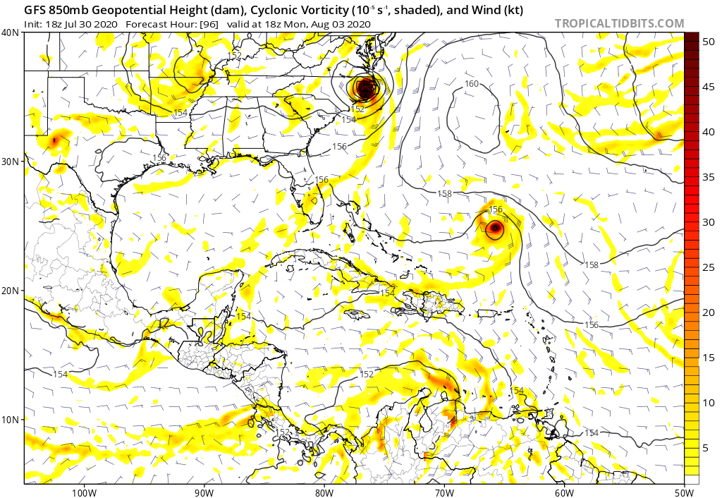
Re: 2020 Global Model Runs Discussion (Out thru day 16)
GFS with possibly another system behind this one, looks to recurve it in the wake of Isiais with a displaced to the east Bermuda High due to a strong CONUS trough. Plenty of time to watch though.
0 likes
Re: 2020 Global Model Runs Discussion (Out thru day 16)
gatorcane wrote:GFS with possibly another system behind this one, looks to recurve it in the wake of Isiais with a displaced to the east Bermuda High due to a strong CONUS trough. Plenty of time to watch though.
https://i.postimg.cc/zvHykhFC/gfs-z850-vort-watl-17.png
I believe it’s also shown up in the latest ECMWF and ICON runs, albeit very weak and almost nonexistent.
0 likes
Irene '11 Sandy '12 Hermine '16 5/15/2018 Derecho Fay '20 Isaias '20 Elsa '21 Henri '21 Ida '21
I am only a meteorology enthusiast who knows a decent amount about tropical cyclones. Look to the professional mets, the NHC, or your local weather office for the best information.
I am only a meteorology enthusiast who knows a decent amount about tropical cyclones. Look to the professional mets, the NHC, or your local weather office for the best information.
-
supercane4867
- Category 5

- Posts: 4966
- Joined: Wed Nov 14, 2012 10:43 am
Re: 2020 Global Model Runs Discussion (Out thru day 16)
18z GFS dropped the Caribbean cruiser
0 likes


Re: 2020 Global Model Runs Discussion (Out thru day 16)
12Z CMC is sniffing out a low developing the the MDR starting around Thursday and traversing the west north westerly
to North of Puerto Rico Tuesday the 11th.
Will see if this is a one run and done or not.
https://www.tropicaltidbits.com/analysi ... 0212&fh=12
to North of Puerto Rico Tuesday the 11th.
Will see if this is a one run and done or not.
https://www.tropicaltidbits.com/analysi ... 0212&fh=12
0 likes

Re: 2020 Global Model Runs Discussion (Out thru day 16)
MetroMike wrote:12Z CMC is sniffing out a low developing the the MDR starting around Thursday and traversing the west north westerly
to North of Puerto Rico Tuesday the 11th.
Will see if this is a one run and done or not.
https://www.tropicaltidbits.com/analysi ... 0212&fh=12
Ridging looks to be building back as its looks headed to Bahamas again
1 likes
Re: 2020 Global Model Runs Discussion (Out thru day 16)
MetroMike wrote:12Z CMC is sniffing out a low developing the the MDR starting around Thursday and traversing the west north westerly
to North of Puerto Rico Tuesday the 11th.
Will see if this is a one run and done or not.
https://www.tropicaltidbits.com/analysi ... 0212&fh=12
I think that’s the low-rider the GFS showed on one run a few days ago but quickly dropped afterwards. We’ll see by mid-week if the CMC can sniff out MDR development a second time like it did with Gonzalo.
0 likes
Irene '11 Sandy '12 Hermine '16 5/15/2018 Derecho Fay '20 Isaias '20 Elsa '21 Henri '21 Ida '21
I am only a meteorology enthusiast who knows a decent amount about tropical cyclones. Look to the professional mets, the NHC, or your local weather office for the best information.
I am only a meteorology enthusiast who knows a decent amount about tropical cyclones. Look to the professional mets, the NHC, or your local weather office for the best information.
-
cycloneye

- Admin

- Posts: 149438
- Age: 69
- Joined: Thu Oct 10, 2002 10:54 am
- Location: San Juan, Puerto Rico
Re: 2020 Global Model Runs Discussion (Out thru day 16)
aspen wrote:MetroMike wrote:12Z CMC is sniffing out a low developing the the MDR starting around Thursday and traversing the west north westerly
to North of Puerto Rico Tuesday the 11th.
Will see if this is a one run and done or not.
https://www.tropicaltidbits.com/analysi ... 0212&fh=12
I think that’s the low-rider the GFS showed on one run a few days ago but quickly dropped afterwards. We’ll see by mid-week if the CMC can sniff out MDR development a second time like it did with Gonzalo.
12z ECMWF is also sniffing.

3 likes
Visit the Caribbean-Central America Weather Thread where you can find at first post web cams,radars
and observations from Caribbean basin members Click Here
and observations from Caribbean basin members Click Here
-
HurricaneEric
- Tropical Storm
- Posts: 146
- Age: 31
- Joined: Mon Sep 07, 2015 11:06 am
- Location: Miami, FL
Re: 2020 Global Model Runs Discussion (Out thru day 16)
Euro and CMC seem to be forecasting a favorable environment for a wave (as depicted in the 12z Euro) coming off Africa in about 6-7 days.
This is how the 12z Euro ends at day 10 with slow development (potential threat to the LAs?):
And the 12z CMC at day 10 (faster, more developed, and further north than the Euro):

Nada on GFS so far.
Sent from my iPhone using Tapatalk
This is how the 12z Euro ends at day 10 with slow development (potential threat to the LAs?):
And the 12z CMC at day 10 (faster, more developed, and further north than the Euro):
Nada on GFS so far.
Sent from my iPhone using Tapatalk
0 likes
Irene '99, Katrina '05, Wilma '05, Irma '17 (storms I remember my area getting hurricane force winds/gusts).
The posts in this forum are NOT official forecast and shouldn't be used as such. They are just the opinion of the poster and may or may not be backed by sound meteorological data. For official information, please refer to the experts.
The posts in this forum are NOT official forecast and shouldn't be used as such. They are just the opinion of the poster and may or may not be backed by sound meteorological data. For official information, please refer to the experts.

Re: 2020 Global Model Runs Discussion (Out thru day 16)
HurricaneEric wrote:Euro and CMC seem to be forecasting a favorable environment for a wave (as depicted in the 12z Euro) coming off Africa in about 6-7 days.
This is how the 12z Euro ends at day 10 with slow development (potential threat to the LAs?):https://uploads.tapatalk-cdn.com/20200803/d5d96a7d961e8fb0856f21e8c4c21b82.jpg
And the 12z CMC at day 10 (faster, more developed, and further north than the Euro):
https://uploads.tapatalk-cdn.com/20200803/fb84722b859e1b2db5a750996a02d33b.jpg
Nada on GFS so far.
Sent from my iPhone using Tapatalk
Definately something to watch. The GFS has not done well sniffing out future development this year.
1 likes
-
Kingarabian

- S2K Supporter
- Posts: 16361
- Joined: Sat Aug 08, 2009 3:06 am
- Location: Honolulu, Hawaii
Re: 2020 Global Model Runs Discussion (Out thru day 16)
Very long range 18z GFS coming in with some WCaribb development.
0 likes
RIP Kobe Bryant

Re: 2020 Global Model Runs Discussion (Out thru day 16)
Kingarabian wrote:Very long range 18z GFS coming in with some WCaribb development.
The 12z Para has it also. Looks like a CAG feature.
1 likes
-
cheezyWXguy

- Category 5
- Posts: 6282
- Joined: Mon Feb 13, 2006 12:29 am
- Location: Dallas, TX
Re: 2020 Global Model Runs Discussion (Out thru day 16)
Cpv17 wrote:Kingarabian wrote:Very long range 18z GFS coming in with some WCaribb development.
The 12z Para has it also. Looks like a CAG feature.
Looks like an interaction between the cag feature and a tropical wave. The initial vorticity can be traced back to something that it initializes about a third of the way between Africa and the islands at hour 0.
1 likes
-
Kingarabian
- S2K Supporter
- Posts: 16361
- Joined: Sat Aug 08, 2009 3:06 am
- Location: Honolulu, Hawaii
Re: 2020 Global Model Runs Discussion (Out thru day 16)
00z GFS has it again. So some sort of signal exists.
0 likes
RIP Kobe Bryant
Re: 2020 Global Model Runs Discussion (Out thru day 16)
Kingarabian wrote:00z GFS has it again. So some sort of signal exists.
It kinda of looks like two distinct cores fighting for control over the system. Josephine develops into a decent hurricane. Then a developing Kyle enters its proximity as Josephine weakens due to land interaction and eventually absorbs Josephines remains as he (Kyle) enters into the gulf.
1 likes
-
CyclonicFury

- Category 5
- Posts: 2033
- Age: 27
- Joined: Sun Jul 02, 2017 12:32 pm
- Location: NC
- Contact:
Re: 2020 Global Model Runs Discussion (Out thru day 16)
The signal is likely related to a strong CCKW expected to pass through the Atlantic around the third week of August. This CCKW signal is showing up on the GFS, CFS and EPS. This CCKW may jumpstart the true Atlantic peak period, after a potential lull for the next 1-2 weeks.
4 likes
NCSU B.S. in Meteorology Class of 2021. Tropical weather blogger at http://www.cyclonicfury.com. My forecasts and thoughts are NOT official, for official forecasts please consult the National Hurricane Center.
Re: 2020 Global Model Runs Discussion (Out thru day 16)
Fancy1001 wrote:Kingarabian wrote:00z GFS has it again. So some sort of signal exists.
It kinda of looks like two distinct cores fighting for control over the system. Josephine develops into a decent hurricane. Then a developing Kyle enters its proximity, heading northwest towards the gulf as Josephine weakens due to land interaction, and eventually absorbs Josephine's remains as he (Kyle) enters into the gulf.
0 likes
Re: 2020 Global Model Runs Discussion (Out thru day 16)
Fancy1001 wrote:Fancy1001 wrote:Kingarabian wrote:00z GFS has it again. So some sort of signal exists.
It kinda of looks like two distinct cores fighting for control over the system. Josephine develops into a decent hurricane. Then a developing Kyle enters its proximity, heading northwest towards the gulf as Josephine weakens due to land interaction, and eventually absorbs Josephine's remains as he (Kyle) enters into the gulf.
There's even a little fujiwhara effect.
Would that system become kyle, or would it still be considered Josephine?
0 likes


Who is online
Users browsing this forum: No registered users and 85 guests