2020 Global Model Runs Discussion (Out thru day 16)
Moderator: S2k Moderators
Forum rules

The posts in this forum are NOT official forecasts and should not be used as such. They are just the opinion of the poster and may or may not be backed by sound meteorological data. They are NOT endorsed by any professional institution or STORM2K. For official information, please refer to products from the National Hurricane Center and National Weather Service.
-
SFLcane

- S2K Supporter

- Posts: 10281
- Age: 48
- Joined: Sat Jun 05, 2010 1:44 pm
- Location: Lake Worth Florida
Re: 2020 Global Model Runs Discussion (Out thru day 16)
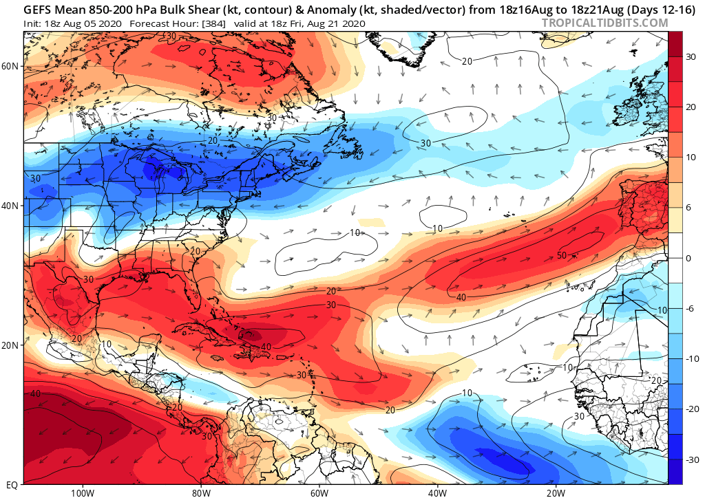
Shear will be extremely hostile next 2 weeks. Likely GFS bias
0 likes

Re: 2020 Global Model Runs Discussion (Out thru day 16)
DorkyMcDorkface wrote:The thing about the GFS' scenario of a CAG-like setup is that historically, climatology does not support such an event. Central American Gyres are almost exclusively an early-season and late-season phenomenon. August is a month where any truly barotropic cyclogenesis originates from tropical waves. So I really do have my doubts about this - I'd chalk it up to the GFS' classic bias with overamplifying the MJO in phase 8/1 more than anything, outside of the fact that this is in the 300+ hour range and therefore should be taken with a grain of salt by default...-
I don't agree with anything 16 days out. But I'm sure we're headed back for 8. As Scott in Atlanta said the other day, EC takes the shortcut across the circle. GFS-based and other US and world models want to wrap it across through 5-6-7. But it's only days in the low teens. So barely two weeks or less til we are back there. Anything could happen to speed that up or slow it down. I haven't been watching Asian or Indian Ocean weather patterns that much, so I am not armed with the information I'd want to have to defend that. But still. We're headed back toward 8 soon enough. Hopefully we don't skip it completely and drop into Deep 2 or anything.
https://www.cpc.ncep.noaa.gov/products/ ... r_wh.shtml
0 likes
-
Blown Away

- S2K Supporter
- Posts: 10253
- Joined: Wed May 26, 2004 6:17 am
Re: 2020 Global Model Runs Discussion (Out thru day 16)

00z EURO starting to show a LLC in the strike position near NE Caribbean in 240 hours... Something to watch for in coming days...
0 likes
Hurricane Eye Experience: David 79, Irene 99, Frances 04, Jeanne 04, Wilma 05… Hurricane Brush Experience: Andrew 92, Erin 95, Floyd 99, Matthew 16, Irma 17, Ian 22, Nicole 22…
-
SFLcane
- S2K Supporter
- Posts: 10281
- Age: 48
- Joined: Sat Jun 05, 2010 1:44 pm
- Location: Lake Worth Florida
Re: 2020 Global Model Runs Discussion (Out thru day 16)
Blown Away wrote:https://i.imgur.com/KbCCkqx.gif
00z EURO starting to show a LLC in the strike position near NE Caribbean in 240 hours... Something to watch for in coming days...
If you look at the moisture it's surrounded by dry air. Nothing on the EPS. Probably end up like 94L
0 likes
-
Blown Away
- S2K Supporter
- Posts: 10253
- Joined: Wed May 26, 2004 6:17 am
Re: 2020 Global Model Runs Discussion (Out thru day 16)
SFLcane wrote:Blown Away wrote:https://i.imgur.com/KbCCkqx.gif
00z EURO starting to show a LLC in the strike position near NE Caribbean in 240 hours... Something to watch for in coming days...
If you look at the moisture it's surrounded by dry air. Nothing on the EPS. Probably end up like 94L
True, the TW would likely continue WNW in the low level flow and this season so far seems to be home growns that develop quickly near the coast if they find a sweet spot...
0 likes
Hurricane Eye Experience: David 79, Irene 99, Frances 04, Jeanne 04, Wilma 05… Hurricane Brush Experience: Andrew 92, Erin 95, Floyd 99, Matthew 16, Irma 17, Ian 22, Nicole 22…

Re: 2020 Global Model Runs Discussion (Out thru day 16)
African Easterly Jet is forecast to dissipate in 78 hr.
The lid for the MDR / CV TCs will come off once SAL settles down a bit.
http://www.stormsurfing.com/cgi/display ... a=glob_250
The lid for the MDR / CV TCs will come off once SAL settles down a bit.
http://www.stormsurfing.com/cgi/display ... a=glob_250
1 likes
Re: 2020 Global Model Runs Discussion (Out thru day 16)
GCANE wrote:African Easterly Jet is forecast to dissipate in 78 hr.
The lid for the MDR / CV TCs will come off once SAL settles down a bit.
http://www.stormsurfing.com/cgi/display ... a=glob_250
Just noticed, Rossby waves in the Pacific taking a turn to the north.
Opens the door for the ConUS.
1 likes
Re: 2020 Global Model Runs Discussion (Out thru day 16)
ICON valid for next Thursday at 7pm Central

0 likes
-
cycloneye

- Admin

- Posts: 149438
- Age: 69
- Joined: Thu Oct 10, 2002 10:54 am
- Location: San Juan, Puerto Rico
Re: 2020 Global Model Runs Discussion (Out thru day 16)
12z GFS= Nothing in Western Caribbean. It was phanthom.
1 likes
Visit the Caribbean-Central America Weather Thread where you can find at first post web cams,radars
and observations from Caribbean basin members Click Here
and observations from Caribbean basin members Click Here
-
SouthFLTropics

- Category 5

- Posts: 4258
- Age: 50
- Joined: Thu Aug 14, 2003 8:04 am
- Location: Port St. Lucie, Florida
Re: 2020 Global Model Runs Discussion (Out thru day 16)
12z Euro starting to get into the MDR action as early as next Thursday

2 likes
Fourth Generation Florida Native
Personal Storm History: David 79, Andrew 92, Erin 95, Floyd 99, Irene 99, Frances 04, Jeanne 04, Wilma 05, Matthew 16, Irma 17, Ian 22, Nicole 22, Milton 24
Personal Storm History: David 79, Andrew 92, Erin 95, Floyd 99, Irene 99, Frances 04, Jeanne 04, Wilma 05, Matthew 16, Irma 17, Ian 22, Nicole 22, Milton 24
-
SouthFLTropics
- Category 5
- Posts: 4258
- Age: 50
- Joined: Thu Aug 14, 2003 8:04 am
- Location: Port St. Lucie, Florida
Re: 2020 Global Model Runs Discussion (Out thru day 16)
0 likes
Fourth Generation Florida Native
Personal Storm History: David 79, Andrew 92, Erin 95, Floyd 99, Irene 99, Frances 04, Jeanne 04, Wilma 05, Matthew 16, Irma 17, Ian 22, Nicole 22, Milton 24
Personal Storm History: David 79, Andrew 92, Erin 95, Floyd 99, Irene 99, Frances 04, Jeanne 04, Wilma 05, Matthew 16, Irma 17, Ian 22, Nicole 22, Milton 24
-
Dean4Storms
- S2K Supporter
- Posts: 6358
- Age: 63
- Joined: Sun Aug 31, 2003 1:01 pm
- Location: Miramar Bch. FL
Re: 2020 Global Model Runs Discussion (Out thru day 16)
Steve wrote:MoliNuno wrote:Dean4Storms wrote:So far this season not so impressed, outside of Hanna ramping up at the last minute in the western Gulf the MDR has not been so friendly to TW's with SAL continuing to blanket much of the Tropical Atlantic. Isaias also struggled with shear and dry air and not until it reached the NE Carib. Sea did it get its act together and even that was sheared. I know we're now past the I named storm but most of that was short lived weak systems that 50 yrs ago never got named. I'm not seeing much in regards to favorable conditions yet and here we are approaching mid August in regards to the MDR. The Euro ENS are predicting rising heights over Eastern NA at 500mb down the road and usually with that and the MJO coming around to 8,1,2,3 you would think the Carib. Sea, Gulf or off the SE US Coast something would pop underneath.
Thats because we're now in the satellite era and with better tools can identify developing cyclones...
1000%. Ubontwo is dead on also. It's Bastardi-speak stuff. Idgaf what they did or didn't classify 50 years ago. That was 50 years ago. I'm not accusing Dean of being a parrot. It's just a statement like a lot of other stuff that gets repeated and creeps into people's ideas and beliefs. Sometimes those are right. Often they become so-called urban legends. It's 2020. Classify that which should be classified IMHO.
Well you're right I'm not a parrot of anyone else. I am in my latter 50's and have witnessed the change in some storms getting a name that didn't happen in the 60's and 70's and even into the 80's. I was born and grew up in Florida and have been into meteorology since elementary school following the tropics intently visiting the NWS office in Jax often and over at George Winterling's (Google Him) house discussing weather all the time and can say honestly that I myself witnessed some storms not get named back then that today I know get named. I have no reason or agenda to tell you a lie about it or fabricate it, they followed the science on confirming a circulation and it was hard to do back then before the technology of today.
1 likes

Re: 2020 Global Model Runs Discussion (Out thru day 16)
SouthFLTropics wrote::uarrow: Actually, after looking at the run some more, it starts spinning it up in the MDR by next Wednesday.
Yeah but it falls apart the closer it gets to the Caribbean. Stronger than the last run though.
0 likes
-
toad strangler

- S2K Supporter
- Posts: 4546
- Joined: Sun Jul 28, 2013 3:09 pm
- Location: Earth
- Contact:
Re: 2020 Global Model Runs Discussion (Out thru day 16)
Cpv17 wrote:SouthFLTropics wrote::uarrow: Actually, after looking at the run some more, it starts spinning it up in the MDR by next Wednesday.
Yeah but it falls apart the closer it gets to the Caribbean. Stronger than the last run though.
Gotta watch it. Tis the season. AS always, wait for ensembles. It's not like the ghost the GFS was trying to spin up the last couple of days. This is a real traceable AEW, not some spurious voracity flowing off of Venezuela.
0 likes
My Weather Station
https://www.wunderground.com/dashboard/pws/KFLPORTS603
https://www.wunderground.com/dashboard/pws/KFLPORTS603
Re: 2020 Global Model Runs Discussion (Out thru day 16)
toad strangler wrote:Cpv17 wrote:SouthFLTropics wrote::uarrow: Actually, after looking at the run some more, it starts spinning it up in the MDR by next Wednesday.
Yeah but it falls apart the closer it gets to the Caribbean. Stronger than the last run though.
Gotta watch it. Tis the season. AS always, wait for ensembles. It's not like the ghost the GFS was trying to spin up the last couple of days. This is a real traceable AEW, not some spurious voracity flowing off of Venezuela.
I feel like it’ll turn out more like what the ICON is showing.
1 likes
-
Blown Away
- S2K Supporter
- Posts: 10253
- Joined: Wed May 26, 2004 6:17 am
Re: 2020 Global Model Runs Discussion (Out thru day 16)

12z EURO... Consistently picking up a low pressure in the MDR next week and takes an Isaias type track over Puerto Rico (Luis Again)...
2 likes
Hurricane Eye Experience: David 79, Irene 99, Frances 04, Jeanne 04, Wilma 05… Hurricane Brush Experience: Andrew 92, Erin 95, Floyd 99, Matthew 16, Irma 17, Ian 22, Nicole 22…
-
Dean4Storms
- S2K Supporter
- Posts: 6358
- Age: 63
- Joined: Sun Aug 31, 2003 1:01 pm
- Location: Miramar Bch. FL
Re: 2020 Global Model Runs Discussion (Out thru day 16)
Blown Away wrote:https://i.imgur.com/BvJcs21.gif
12z EURO... Consistently picking up a low pressure in the MDR next week and takes an Isaias type track over Puerto Rico (Luis Again)...
Note how fast it's moving, gonna have a hard time developing moving that fast.
1 likes
-
toad strangler
- S2K Supporter
- Posts: 4546
- Joined: Sun Jul 28, 2013 3:09 pm
- Location: Earth
- Contact:
Re: 2020 Global Model Runs Discussion (Out thru day 16)
Dean4Storms wrote:Blown Away wrote:https://i.imgur.com/BvJcs21.gif
12z EURO... Consistently picking up a low pressure in the MDR next week and takes an Isaias type track over Puerto Rico (Luis Again)...
Note how fast it's moving, gonna have a hard time developing moving that fast.
Those are 24 hour intervals. I don't think it's overly fast.
4 likes
My Weather Station
https://www.wunderground.com/dashboard/pws/KFLPORTS603
https://www.wunderground.com/dashboard/pws/KFLPORTS603
-
cycloneye
- Admin
- Posts: 149438
- Age: 69
- Joined: Thu Oct 10, 2002 10:54 am
- Location: San Juan, Puerto Rico
Re: 2020 Global Model Runs Discussion (Out thru day 16)
toad strangler wrote:Dean4Storms wrote:Blown Away wrote:https://i.imgur.com/BvJcs21.gif
12z EURO... Consistently picking up a low pressure in the MDR next week and takes an Isaias type track over Puerto Rico (Luis Again)...
Note how fast it's moving, gonna have a hard time developing moving that fast.
Those are 24 hour intervals. I don't think it's overly fast.
In fact is more slower on this run.
1 likes
Visit the Caribbean-Central America Weather Thread where you can find at first post web cams,radars
and observations from Caribbean basin members Click Here
and observations from Caribbean basin members Click Here
-
ScottNAtlanta

- Category 5
- Posts: 2535
- Joined: Sat May 25, 2013 3:11 pm
- Location: Atlanta, GA
Re: 2020 Global Model Runs Discussion (Out thru day 16)
Steve wrote:Thats because we're now in the satellite era and with better tools can identify developing cyclones...
1000%. Ubontwo is dead on also. It's Bastardi-speak stuff. Idgaf what they did or didn't classify 50 years ago. That was 50 years ago. I'm not accusing Dean of being a parrot. It's just a statement like a lot of other stuff that gets repeated and creeps into people's ideas and beliefs. Sometimes those are right. Often they become so-called urban legends. It's 2020. Classify that which should be classified IMHO.
I think they call that improving your scientific knowledge and improved technology, and why that is a bad thing to some people is beyond my understanding
7 likes
The posts in this forum are NOT official forecast and should not be used as such. They are just the opinion of the poster and may or may not be backed by sound meteorological data. They are NOT endorsed by any professional institution or storm2k.org. For official information, please refer to the NHC and NWS products.
Who is online
Users browsing this forum: gfsperpendicular and 121 guests