2020 Indicators: SST's / SAL / MSLP / Steering / Shear / Instability / Sat Images
Moderator: S2k Moderators
Forum rules

The posts in this forum are NOT official forecasts and should not be used as such. They are just the opinion of the poster and may or may not be backed by sound meteorological data. They are NOT endorsed by any professional institution or STORM2K. For official information, please refer to products from the National Hurricane Center and National Weather Service.
-
gatorcane

- S2K Supporter

- Posts: 23708
- Age: 48
- Joined: Sun Mar 13, 2005 3:54 pm
- Location: Boca Raton, FL
Re: 2020 Indicators: SST's / SAL / MSLP / Steering / Shear / Instability / Sat Images
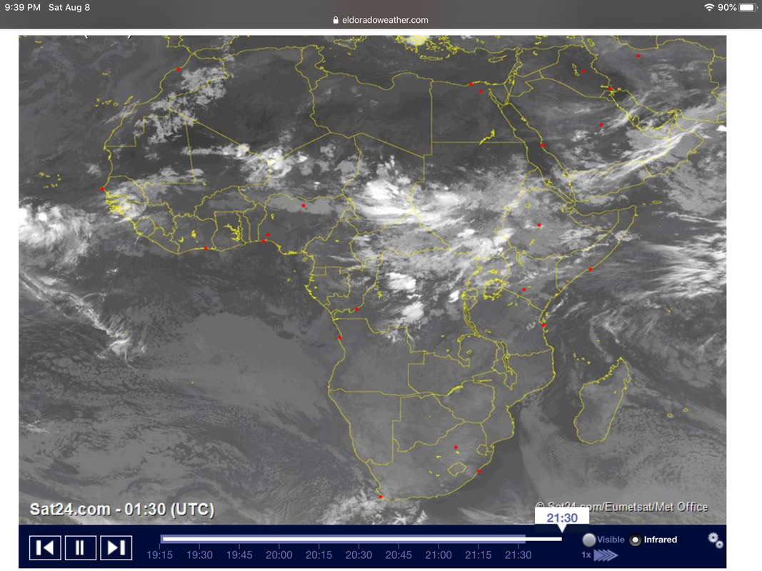
Convection over Africa is really not that impressive at the moment considering we are entering mid August soon. It probably is due to the dry phase of the MJO, but in some years like 2017, I remember very distinct and strong waves lining up over the continent around now. As we head deeper into August, let’s see if we start seeing more vigorous waves as we go up the climatological ramp up to the Cape Verde season which usually begins around Aug 15:
1 likes
-
CyclonicFury

- Category 5

- Posts: 2033
- Age: 27
- Joined: Sun Jul 02, 2017 12:32 pm
- Location: NC
- Contact:
Re: 2020 Indicators: SST's / SAL / MSLP / Steering / Shear / Instability / Sat Images
gatorcane wrote:Convection over Africa is really not that impressive at the moment considering we are entering mid August soon. It probably is due to the dry phase of the MJO, but in some years like 2017, I remember very distinct and strong waves lining up over the continent around now. As we head deeper into August, let’s see if we start seeing more vigorous waves as we go up the climatological ramp up to the Cape Verde season which usually begins around Aug 15:
https://i.postimg.cc/cLwgt3WC/987662-B6-CD7-E-4-B40-A7-C8-6-A36818-A75-E5.png
The suppressed CCKW/MJO pulse is right over Africa and Sahel rainfall has been well above normal since May. We should see Africa really light up convectively in about 2 weeks.
10 likes
NCSU B.S. in Meteorology Class of 2021. Tropical weather blogger at http://www.cyclonicfury.com. My forecasts and thoughts are NOT official, for official forecasts please consult the National Hurricane Center.


Re: 2020 Indicators: SST's / SAL / MSLP / Steering / Shear / Instability / Sat Images
CyclonicFury wrote:gatorcane wrote:Convection over Africa is really not that impressive at the moment considering we are entering mid August soon. It probably is due to the dry phase of the MJO, but in some years like 2017, I remember very distinct and strong waves lining up over the continent around now. As we head deeper into August, let’s see if we start seeing more vigorous waves as we go up the climatological ramp up to the Cape Verde season which usually begins around Aug 15:
https://i.postimg.cc/cLwgt3WC/987662-B6-CD7-E-4-B40-A7-C8-6-A36818-A75-E5.png
The suppressed CCKW/MJO pulse is right over Africa and Sahel rainfall has been well above normal since May. We should see Africa really light up convectively in about 2 weeks.
Agreed, also there has been a tendency for a few waves that later became systems to blossom over WA before heading into the Atlantic
0 likes
-
TheStormExpert
Re: 2020 Indicators: SST's / SAL / MSLP / Steering / Shear / Instability / Sat Images
I’d believe these “Season Cancel” posts if it was September 9th and not only August 9th. As several have stated things can and will most likely change on a dime!
3 likes

Re: 2020 Indicators: SST's / SAL / MSLP / Steering / Shear / Instability / Sat Images
TheStormExpert wrote:I’d believe these “Season Cancel” posts if it was September 9th and not only August 9th. As several have stated things can and will most likely change on a dime!
Could you be more specific or perhaps quote those several "season cancel" posts that you are referring to?
5 likes
Andy D
(For official information, please refer to the NHC and NWS products.)
(For official information, please refer to the NHC and NWS products.)
-
gatorcane
- S2K Supporter
- Posts: 23708
- Age: 48
- Joined: Sun Mar 13, 2005 3:54 pm
- Location: Boca Raton, FL
Re: 2020 Indicators: SST's / SAL / MSLP / Steering / Shear / Instability / Sat Images
Wet-phase of MJO over the EPAC but if the CFS is right should slide some into the Western Caribbean over the next week or two. That might enhance chances of development in the Western Caribbean but for now models insist activity will be on the EPAC side.
0 likes
-
ScottNAtlanta

- Category 5
- Posts: 2535
- Joined: Sat May 25, 2013 3:11 pm
- Location: Atlanta, GA
Re: 2020 Indicators: SST's / SAL / MSLP / Steering / Shear / Instability / Sat Images
It's coming back around pretty quickly
5 likes
The posts in this forum are NOT official forecast and should not be used as such. They are just the opinion of the poster and may or may not be backed by sound meteorological data. They are NOT endorsed by any professional institution or storm2k.org. For official information, please refer to the NHC and NWS products.
-
TheStormExpert
Re: 2020 Indicators: SST's / SAL / MSLP / Steering / Shear / Instability / Sat Images
chaser1 wrote:TheStormExpert wrote:I’d believe these “Season Cancel” posts if it was September 9th and not only August 9th. As several have stated things can and will most likely change on a dime!
Could you be more specific or perhaps quote those several "season cancel" posts that you are referring to?
Look for yourself. I’m not going to call people out.
4 likes
-
CyclonicFury
- Category 5
- Posts: 2033
- Age: 27
- Joined: Sun Jul 02, 2017 12:32 pm
- Location: NC
- Contact:
Re: 2020 Indicators: SST's / SAL / MSLP / Steering / Shear / Instability / Sat Images
It's important to remember the rarity of MDR hurricanes early in the season. I compiled a list of the date of first Atlantic hurricane (65+ kt) in the MDR (20-60W, 10-20N) in hyperactive (153+) Atlantic hurricane seasons since 1995:
1995 - August 11
1996 - July 7
1998 - August 25
1999 - August 22
2003 - August 30
2004 - August 15
2005 - September 19*
2010 - August 23
2017 - August 31
*Hurricane Emily became a hurricane at 11.6N, 60.2W on July 14 in 2005 but since it was west of 60W, I did not include it.
6 of the 9 hyperactive years did not have a MDR hurricane before August 20, though 8 of the 9 had at least one MDR hurricane before September 1.
It shouldn't be a surprise Gonzalo didn't reach hurricane strength - it failing to do so was likely not a sign of an unfavorable MDR, but rather a favorable enough MDR to allow a strong tropical storm to form so early. 95L isn't particularly likely to reach hurricane strength either, but even if it fails to develop, that is not necessarily a sign of a dead MDR at peak. The MDR doesn't really start to ramp up quickly for intense TCs until the last third of August.
10 likes
NCSU B.S. in Meteorology Class of 2021. Tropical weather blogger at http://www.cyclonicfury.com. My forecasts and thoughts are NOT official, for official forecasts please consult the National Hurricane Center.
-
Kingarabian

- S2K Supporter
- Posts: 16361
- Joined: Sat Aug 08, 2009 3:06 am
- Location: Honolulu, Hawaii
Re: 2020 Indicators: SST's / SAL / MSLP / Steering / Shear / Instability / Sat Images
ScottNAtlanta wrote:It's coming back around pretty quickly
[url]https://www.cpc.ncep.noaa.gov/products/precip/CWlink/MJO/diagram_40days_forecast_GEFS_member.gif[url]
Well that explains it.
I pay attention to the MJO a lot during the winter and spring, but I don't look at it enough hurricane season. That GFS MJO forecast makes sense in why the model is going crazy with activity for the EPAC
0 likes
RIP Kobe Bryant
-
Kingarabian
- S2K Supporter
- Posts: 16361
- Joined: Sat Aug 08, 2009 3:06 am
- Location: Honolulu, Hawaii
Re: 2020 Indicators: SST's / SAL / MSLP / Steering / Shear / Instability / Sat Images
CyclonicFury wrote:It's important to remember the rarity of MDR hurricanes early in the season. I compiled a list of the date of first Atlantic hurricane (65+ kt) in the MDR (20-60W, 10-20N) in hyperactive (153+) Atlantic hurricane seasons since 1995:
1995 - August 11
1996 - July 7
1998 - August 25
1999 - August 22
2003 - August 30
2004 - August 15
2005 - September 19*
2010 - August 23
2017 - August 31
*Hurricane Emily became a hurricane at 11.6N, 60.2W on July 14 in 2005 but since it was west of 60W, I did not include it.
6 of the 9 hyperactive years did not have a MDR hurricane before August 20, though 8 of the 9 had at least one MDR hurricane before September 1.
It shouldn't be a surprise Gonzalo didn't reach hurricane strength - it failing to do so was likely not a sign of an unfavorable MDR, but rather a favorable enough MDR to allow a strong tropical storm to form so early. 95L isn't particularly likely to reach hurricane strength either, but even if it fails to develop, that is not necessarily a sign of a dead MDR at peak. The MDR doesn't really start to ramp up quickly for intense TCs until the last third of August.
Good points. A difference of about 5-10kts is all it was. But I think there's a compelling case that Gonzalo was a hurricane at some point.
7 likes
RIP Kobe Bryant

Re: 2020 Indicators: SST's / SAL / MSLP / Steering / Shear / Instability / Sat Images
I rounded up some comparisons of mid-level relative humidity (700 mb) for a couple of hurricane seasons using the same scale.
2005

2010

2013

2017

2020

2005
2010
2013
2017
2020
10 likes
-
TheStormExpert
Re: 2020 Indicators: SST's / SAL / MSLP / Steering / Shear / Instability / Sat Images
KAlexPR wrote:I rounded up some comparisons of mid-level relative humidity (700 mb) for a couple of hurricane seasons using the same scale.
2005
https://psl.noaa.gov/tmp/composites/compday.FzU7axE2SS.gif
2010
https://psl.noaa.gov/tmp/composites/compday.tiUb88Or5L.gif
2013
https://psl.noaa.gov/tmp/composites/compday.iVKitMl5_S.gif
2017
https://psl.noaa.gov/tmp/composites/compday.UqKCEplZbZ.gif
2020
https://psl.noaa.gov/tmp/composites/compday.eKDOyCVe2_.gif
How does this compare for the same timeframe for the last two seasons?
0 likes
Re: 2020 Indicators: SST's / SAL / MSLP / Steering / Shear / Instability / Sat Images
TheStormExpert wrote:How does this compare for the same timeframe for the last two seasons?
Surprisingly, mid-level relative humidity in 2019 was very high. Despite that, total activity was weaker than expected due to warmer subtropics and a cooler MDR. This caused instability to decrease some during the peak, creating a more hostile background state. This year is a different story, however, as the MDR is warmer relative to the subtropics, vertical wind shear is below average, MSLPs reached record low levels in July, and the MJO should be in a favorable phase promoting activity further.
2018 (7/24 - 8/07)

2019 (7/24 - 8/07)

2019 (8/24 - 9/07)

Last edited by KAlexPR on Sun Aug 09, 2020 5:14 pm, edited 1 time in total.
1 likes
-
AveryTheComrade
- Tropical Depression

- Posts: 76
- Joined: Fri Jul 10, 2020 9:19 pm
Re: 2020 Indicators: SST's / SAL / MSLP / Steering / Shear / Instability / Sat Images
TheStormExpert wrote:The classic +AMO look is starting to quickly fade as warm SST anomalies are starting to pop up in the mid-latitude subtropical Atlantic. Wonder if this will put a damper on things in the Tropical Atlantic?
https://i.ibb.co/jM5c46r/A966825-C-BC86-421-C-A864-D0-BE4-B648033.gif
https://i.ibb.co/TkSqL9z/34-FBBB58-15-CF-46-A1-8613-3613-E8-E8-EB09.gif
https://i.ibb.co/D9pxvdV/catlssta.png
"The classic +AMO look is starting to quickly fade as warm SST anomalies are starting to pop up in the mid-latitude subtropical Atlantic. Wonder if this will put a damper on things in the Tropical Atlantic in 2005?"

11 likes
-
TheStormExpert
Re: 2020 Indicators: SST's / SAL / MSLP / Steering / Shear / Instability / Sat Images
Last edited by TheStormExpert on Sun Aug 09, 2020 6:37 pm, edited 1 time in total.
0 likes
-
toad strangler

- S2K Supporter
- Posts: 4546
- Joined: Sun Jul 28, 2013 3:09 pm
- Location: Earth
- Contact:

Re: 2020 Indicators: SST's / SAL / MSLP / Steering / Shear / Instability / Sat Images
[Tweet][/Tweet]
Tweet Not Found
This was the most recent
https://twitter.com/i/status/1292545130893901830
toad strangler wrote:TheStormExpert wrote:https://twitter.com/thezodiac13/status/1292568349797482503
Tweet Not Found
This was the most recent
https://twitter.com/i/status/1292545130893901830
0 likes
-
SFLcane

- S2K Supporter
- Posts: 10281
- Age: 48
- Joined: Sat Jun 05, 2010 1:44 pm
- Location: Lake Worth Florida
Re: 2020 Indicators: SST's / SAL / MSLP / Steering / Shear / Instability / Sat Images
We have about 10 days folks before all he’ll breaks loose across the Atlantic. Did a quick comparison with the Sept 17 VP200 anomalies to the forecast pattern over the next six weeks. Very close match. Gonna to be bad! I hope everyone is ready
1 likes
-
USTropics
- Professional-Met

- Posts: 2738
- Joined: Sun Aug 12, 2007 3:45 am
- Location: Florida State University
Re: 2020 Indicators: SST's / SAL / MSLP / Steering / Shear / Instability / Sat Images
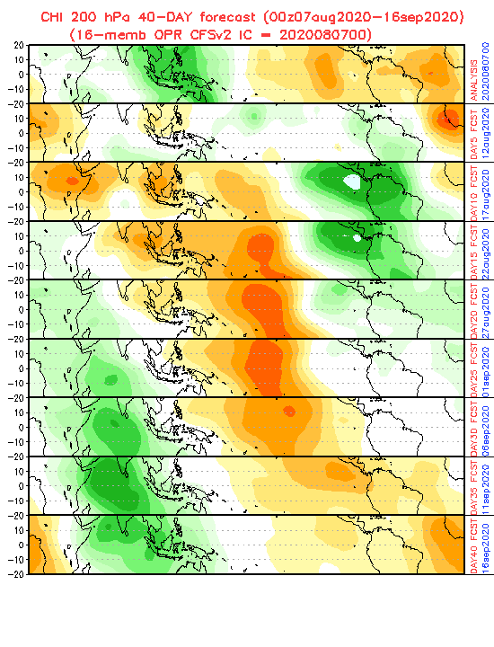
CFS has been very consistent with the VP anomaly propagation. That is some  VP anomalies if that verifies starting next week (off the chart in fact - no wonder the globals are blowing up the Pacific next week). Look for action to pickup in the western Atlantic afterwards (~August 18th) and then propagate towards the MDR/eastern Atlantic towards the latter parts of August:

7 likes
Who is online
Users browsing this forum: No registered users and 199 guests