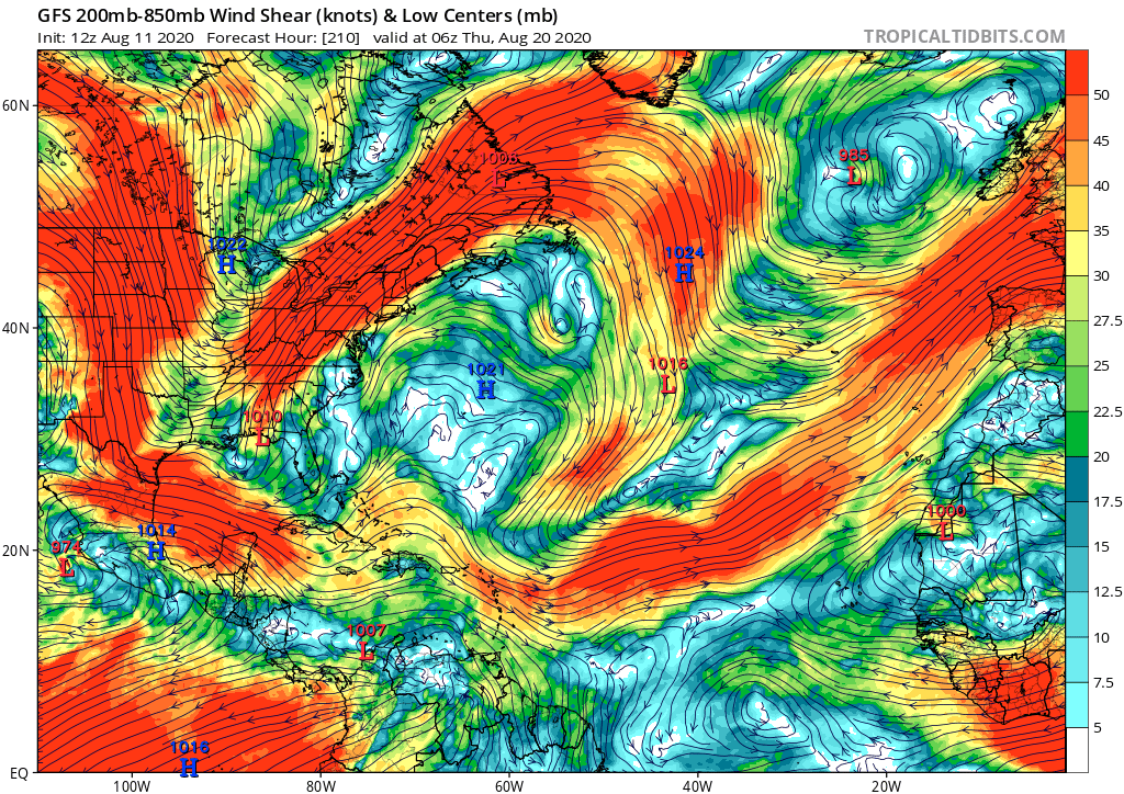
2020 Global Model Runs Discussion (Out thru day 16)

This is the general tropical discussion area. Anyone can take their shot at predicting a storms path.

Moderator: S2k Moderators

Forum rules

The posts in this forum are NOT official forecasts and should not be used as such. They are just the opinion of the poster and may or may not be backed by sound meteorological data. They are NOT endorsed by any professional institution or STORM2K. For official information, please refer to products from the National Hurricane Center and National Weather Service.

Help Support Storm2K
Message
Author
User avatar
SFLcane
S2K Supporter
S2K Supporter
Posts: 10163
Age: 47
Joined: Sat Jun 05, 2010 1:44 pm
Location: Lake Worth Florida

Re: 2020 Global Model Runs Discussion (Out thru day 16)

#1241 Postby SFLcane » Tue Aug 11, 2020 9:35 pm

TheStormExpert wrote:
gatorcane wrote:Aug 20th “ring the bell” date looks pretty rough across the Atlantic for tropical development if the GFS is correct:

https://i.postimg.cc/vHxzzTQR/gfs-shear-atl-36.png

P.S. Things were more interesting before the model upgrades where we could at least talk about some phantoms. Now it seems the models may have the opposite issue

I'll take the phantom storms at this point. The global models have been pure garbage this year so I wouldn't put too much stock into a shear forecast nine days out. Hopefully conditions improve otherwise the forecasts for a "Extremely Active Season" could be in jeopardy.


The mjo is a very slow moving wave which is currently still in the e-pac and shearing the Atlantic that will continue for the next next 5-7 days Possibly till months end. These season cancel posts are really starting to be “ extra” in this thread. The storms are coming patience

Image
1 likes   

TheStormExpert

Re: 2020 Global Model Runs Discussion (Out thru day 16)

#1242 Postby TheStormExpert » Tue Aug 11, 2020 9:41 pm

SFLcane wrote:
TheStormExpert wrote:
gatorcane wrote:Aug 20th “ring the bell” date looks pretty rough across the Atlantic for tropical development if the GFS is correct:

https://i.postimg.cc/vHxzzTQR/gfs-shear-atl-36.png

P.S. Things were more interesting before the model upgrades where we could at least talk about some phantoms. Now it seems the models may have the opposite issue

I'll take the phantom storms at this point. The global models have been pure garbage this year so I wouldn't put too much stock into a shear forecast nine days out. Hopefully conditions improve otherwise the forecasts for a "Extremely Active Season" could be in jeopardy.


The mjo is a very slow moving wave which is currently still in the e-pac and shearing the Atlantic that will continue for the next next 5-7 days Possibly till months end. These season cancel posts are really starting to be “ extra” in this thread. The storms are coming patience

https://iili.io/dVPPJ1.gif

Well the timeframe seems to be getting pushed back. Not saying the lid won't come off, but the East Pacific deciding to finally ignite after a VERY quiet start definitely caught me off guard.
2 likes   

User avatar
toad strangler
S2K Supporter
S2K Supporter
Posts: 4543
Joined: Sun Jul 28, 2013 3:09 pm
Location: Earth
Contact:

Re: 2020 Global Model Runs Discussion (Out thru day 16)

#1243 Postby toad strangler » Tue Aug 11, 2020 9:53 pm

SFLcane wrote:
TheStormExpert wrote:
gatorcane wrote:Aug 20th “ring the bell” date looks pretty rough across the Atlantic for tropical development if the GFS is correct:

https://i.postimg.cc/vHxzzTQR/gfs-shear-atl-36.png

P.S. Things were more interesting before the model upgrades where we could at least talk about some phantoms. Now it seems the models may have the opposite issue

I'll take the phantom storms at this point. The global models have been pure garbage this year so I wouldn't put too much stock into a shear forecast nine days out. Hopefully conditions improve otherwise the forecasts for a "Extremely Active Season" could be in jeopardy.


The mjo is a very slow moving wave which is currently still in the e-pac and shearing the Atlantic that will continue for the next next 5-7 days Possibly till months end. These season cancel posts are really starting to be “ extra” in this thread. The storms are coming patience

https://iili.io/dVPPJ1.gif


It looks like the Euro and GFS have an agreement on the endgame for 95L. It's all about whether or not it becomes Josephine before said endgame happens.
1 likes   

User avatar
Steve
S2K Supporter
S2K Supporter
Posts: 9620
Joined: Sat Apr 05, 2003 11:41 pm
Location: Not a state-caster

Re: 2020 Global Model Runs Discussion (Out thru day 16)

#1244 Postby Steve » Tue Aug 11, 2020 10:38 pm

TheStormExpert wrote:
gatorcane wrote:Aug 20th “ring the bell” date looks pretty rough across the Atlantic for tropical development if the GFS is correct:

https://i.postimg.cc/vHxzzTQR/gfs-shear-atl-36.png

P.S. Things were more interesting before the model upgrades where we could at least talk about some phantoms. Now it seems the models may have the opposite issue

I'll take the phantom storms at this point. The global models have been pure garbage this year so I wouldn't put too much stock into a shear forecast nine days out. Hopefully conditions improve otherwise the forecasts for a "Extremely Active Season" could be in jeopardy.


Maybe it’s just me, but that’s kind of "off".
Last edited by Steve on Tue Aug 11, 2020 10:54 pm, edited 1 time in total.
8 likes   

User avatar
Steve
S2K Supporter
S2K Supporter
Posts: 9620
Joined: Sat Apr 05, 2003 11:41 pm
Location: Not a state-caster

Re: 2020 Global Model Runs Discussion (Out thru day 16)

#1245 Postby Steve » Tue Aug 11, 2020 10:47 pm

Phase 6 MJO heading toward 7 by Thursday and 8 by Friday. You can see the pulse moving eastward with time. And yes, it's less concentrated again tonight in the EPAC than it has been the last several days as it tampers down a hair on that solution. Assumption is that the 00z GFS will show slightly weaker EPAC systems than it did the last couple days. It still might crank out a strong hurricane or two, but its recent runs haven't been putting out mega-storms.
http://mikeventrice.weebly.com/mjo.html

While we could certainly get a couple classified systems in the near-term, except for something stalled out in the middle of the Atlantic, don't expect to see anything extreme in the Western Atlantic for at least several days.
0 likes   

User avatar
Hurricaneman
Category 5
Category 5
Posts: 7351
Age: 45
Joined: Tue Aug 31, 2004 3:24 pm
Location: central florida

Re: 2020 Global Model Runs Discussion (Out thru day 16)

#1246 Postby Hurricaneman » Wed Aug 12, 2020 12:00 am

The 0zGFS is showing around hr 300 3 possible systems

1. Forms south of Cuba
2. Forms near Florida
3. Forms in the eastern Bahamas

What this tells us is that between the 20th sand 25th the lid is going to come off but of course only if the GFS is right which will change many times between now and then
1 likes   

User avatar
eastcoastFL
Category 5
Category 5
Posts: 3901
Age: 43
Joined: Thu Apr 12, 2007 12:29 pm
Location: Palm City, FL

Re: 2020 Global Model Runs Discussion (Out thru day 16)

#1247 Postby eastcoastFL » Wed Aug 12, 2020 4:17 am

Hurricaneman wrote:The 0zGFS is showing around hr 300 3 possible systems

1. Forms south of Cuba
2. Forms near Florida
3. Forms in the eastern Bahamas

What this tells us is that between the 20th sand 25th the lid is going to come off but of course only if the GFS is right which will change many times between now and then


The gfs storm hits Florida as 999mb and then sits over Florida for 3 days and strengthens while doing so...
0 likes   
Personal Forecast Disclaimer:
The posts in this forum are NOT official forecast and should not be used as such. They are just the opinion of the poster and may or may not be backed by sound meteorological data. They are NOT endorsed by any professional institution or storm2k.org. For official information, please refer to the NHC and NWS products.

lsuhurricane
Category 1
Category 1
Posts: 251
Joined: Tue Aug 15, 2017 2:53 pm

Re: 2020 Global Model Runs Discussion (Out thru day 16)

#1248 Postby lsuhurricane » Wed Aug 12, 2020 9:29 am

Evidence of the season going bonkers is certainly present on the Euro Ensembles from last night. Beyond 280 hrs (yeah, I know lala-land) the Gulf of Mexico is completed covered in low pressure systems ranging from TS to major hurricane.
0 likes   

User avatar
aspen
Category 5
Category 5
Posts: 8818
Joined: Sat Oct 12, 2019 7:10 pm
Location: Connecticut, USA

Re: 2020 Global Model Runs Discussion (Out thru day 16)

#1249 Postby aspen » Wed Aug 12, 2020 11:31 am

12z GFS shows a disturbance moving off of the US East Coast in a few days and coalescing into a STC in 5-6 days in the middle of the Atlantic, where it meanders for some time. The GFS has been on and off with this developing, showing everything from no system at all to a 961 mbar major hurricane over the last several days.
2 likes   
Irene '11 Sandy '12 Hermine '16 5/15/2018 Derecho Fay '20 Isaias '20 Elsa '21 Henri '21 Ida '21

I am only a meteorology enthusiast who knows a decent amount about tropical cyclones. Look to the professional mets, the NHC, or your local weather office for the best information.

User avatar
Jr0d
S2K Supporter
S2K Supporter
Posts: 1409
Joined: Tue Aug 27, 2019 10:52 am
Location: Cayo Hueso

Re: 2020 Global Model Runs Discussion (Out thru day 16)

#1250 Postby Jr0d » Wed Aug 12, 2020 11:40 am

aspen wrote:12z GFS shows a disturbance moving off of the US East Coast in a few days and coalescing into a STC in 5-6 days in the middle of the Atlantic, where it meanders for some time. The GFS has been on and off with this developing, showing everything from no system at all to a 961 mbar major hurricane over the last several days.


There is already some spin in the storms off the Carolina's. This maybe the next area to watch
0 likes   

User avatar
Steve
S2K Supporter
S2K Supporter
Posts: 9620
Joined: Sat Apr 05, 2003 11:41 pm
Location: Not a state-caster

Re: 2020 Global Model Runs Discussion (Out thru day 16)

#1251 Postby Steve » Wed Aug 12, 2020 11:46 am

The 12z's are rolling in. NCEP's 8/12 MJO models are all heading for Phase 8 this week and generally toward Phase 1. GFS still develops a mid-latitude system in several days but otherwise still focuses most of the energy down in the EPAC through 288 hours (8/24 00z).

ICON also has a mid-latitude system but moves it out toward Ireland and forms another east of the MA Cape while still showing some semi-organized lows traveling off Africa.
https://www.tropicaltidbits.com/analysi ... 212&fh=180
5 likes   

tolakram
Admin
Admin
Posts: 20009
Age: 62
Joined: Sun Aug 27, 2006 8:23 pm
Location: Florence, KY (name is Mark)

Re: 2020 Global Model Runs Discussion (Out thru day 16)

#1252 Postby tolakram » Wed Aug 12, 2020 11:48 am

We're going to have to start actively trimming the garbage posts in here if this keeps up. We really don't like to overly moderate, but this is ridiculous.

If you (anyone) finds themselves commenting because conditions haven't changed in the past 3 days DON'T COMMENT! If you feel the need to correct someone who noticed things haven't changed in the last 3 days DON'T COMMENT.

PLEASE

This thread is useless if it's filled with the same hyperactive fidgeting as every other thread on here.
9 likes   
M a r k
- - - - -
Join us in chat: Storm2K Chatroom Invite. Android and IOS apps also available.

The posts in this forum are NOT official forecasts and should not be used as such. Posts are NOT endorsed by any professional institution or STORM2K.org. For official information and forecasts, please refer to NHC and NWS products.

User avatar
Ivanhater
Storm2k Moderator
Storm2k Moderator
Posts: 11160
Age: 38
Joined: Fri Jul 01, 2005 8:25 am
Location: Pensacola

Re: 2020 Global Model Runs Discussion (Out thru day 16)

#1253 Postby Ivanhater » Wed Aug 12, 2020 12:12 pm

12Z Gfs still showing a CAG/ low pressure in the western Caribbean and Gulf by late August.

Remember the gfs did great with Cristobal in this type of setup. It had different specifics but the overall idea came to fruition.

I'm still betting we get something out of this by the end of August and it may be a strong system.
3 likes   
Michael

psyclone
S2K Supporter
S2K Supporter
Posts: 4762
Joined: Wed Aug 24, 2005 9:04 pm
Location: palm harbor fl

Re: 2020 Global Model Runs Discussion (Out thru day 16)

#1254 Postby psyclone » Wed Aug 12, 2020 12:16 pm

Ivanhater wrote:12Z Gfs still showing a CAG/ low pressure in the western Caribbean and Gulf by late August.

Remember the gfs did great with Cristobal in this type of setup. It had different specifics but the overall idea came to fruition.

I'm still betting we get something out of this by the end of August and it may be a strong system.


What's odd here is we're very much out of season for a CAG like system and the GFS has a history of false positives in this realm. Having said that...tis the season for close in rapid development. One lesson of some of our massive systems is they weren't much to look at 3 days in advance...Michael 2018 being the most recent example. Certainly worth monitoring. Late August means looking everywhere.
4 likes   

User avatar
gatorcane
S2K Supporter
S2K Supporter
Posts: 23691
Age: 47
Joined: Sun Mar 13, 2005 3:54 pm
Location: Boca Raton, FL

Re: 2020 Global Model Runs Discussion (Out thru day 16)

#1255 Postby gatorcane » Wed Aug 12, 2020 12:37 pm

:uarrow: If all we are seeing from the GFS out through Aug 27th is a CAG over Central America at 300+ hours we are doing pretty well. The model seems reluctant to show any favorable conditions once you cross over the mountains of Central America into the Caribbean. I don’t normally post model images this far out but since there is nothing else of interest in the entire 14 day model run, why not?

Image
0 likes   

User avatar
Ivanhater
Storm2k Moderator
Storm2k Moderator
Posts: 11160
Age: 38
Joined: Fri Jul 01, 2005 8:25 am
Location: Pensacola

Re: 2020 Global Model Runs Discussion (Out thru day 16)

#1256 Postby Ivanhater » Wed Aug 12, 2020 12:49 pm

I'm actually more concerned the gfs isn't showing cape verde systems but western based development. Lowering of pressure in the western Caribbean/Gulf as we head into a primed basin is never good and indeed more worrisome.
6 likes   
Michael

User avatar
aspen
Category 5
Category 5
Posts: 8818
Joined: Sat Oct 12, 2019 7:10 pm
Location: Connecticut, USA

Re: 2020 Global Model Runs Discussion (Out thru day 16)

#1257 Postby aspen » Wed Aug 12, 2020 1:50 pm

12z Euro has a tropical wave move off the coast of Africa in 4 days, and develops a weak TC in the MDR in 144 hours. Let’s see if any other models start showing this, or it goes poor at 00z.
3 likes   
Irene '11 Sandy '12 Hermine '16 5/15/2018 Derecho Fay '20 Isaias '20 Elsa '21 Henri '21 Ida '21

I am only a meteorology enthusiast who knows a decent amount about tropical cyclones. Look to the professional mets, the NHC, or your local weather office for the best information.

User avatar
mcheer23
Professional-Met
Professional-Met
Posts: 436
Age: 32
Joined: Sun Jun 24, 2012 8:24 pm
Location: Sugar Land, Texas

Re: 2020 Global Model Runs Discussion (Out thru day 16)

#1258 Postby mcheer23 » Wed Aug 12, 2020 2:47 pm

aspen wrote:12z Euro has a tropical wave move off the coast of Africa in 4 days, and develops a weak TC in the MDR in 144 hours. Let’s see if any other models start showing this, or it goes poor at 00z.


Euro Ensembles picked it up..... saw some nasty solutions although they were 300+ hours out
3 likes   

User avatar
SFLcane
S2K Supporter
S2K Supporter
Posts: 10163
Age: 47
Joined: Sat Jun 05, 2010 1:44 pm
Location: Lake Worth Florida

Re: 2020 Global Model Runs Discussion (Out thru day 16)

#1259 Postby SFLcane » Wed Aug 12, 2020 2:59 pm

mcheer23 wrote:
aspen wrote:12z Euro has a tropical wave move off the coast of Africa in 4 days, and develops a weak TC in the MDR in 144 hours. Let’s see if any other models start showing this, or it goes poor at 00z.


Euro Ensembles picked it up..... saw some nasty solutions although they were 300+ hours out


Bunch into FL and GOM. That wave coming off this weekend is one to watch.

Image
1 likes   

User avatar
SFLcane
S2K Supporter
S2K Supporter
Posts: 10163
Age: 47
Joined: Sat Jun 05, 2010 1:44 pm
Location: Lake Worth Florida

Re: 2020 Global Model Runs Discussion (Out thru day 16)

#1260 Postby SFLcane » Wed Aug 12, 2020 3:04 pm

Hmm...

Image
1 likes   


Return to “Talkin' Tropics”

Who is online

Users browsing this forum: Hurricaneman and 34 guests