

00z gfs develops this
https://tropicaltidbits.com/analysis/mo ... 1600&fh=54
Robust Tropical Wave SW of Cabo Verde Islands (Is Invest 98L)
Moderator: S2k Moderators
Forum rules

The posts in this forum are NOT official forecasts and should not be used as such. They are just the opinion of the poster and may or may not be backed by sound meteorological data. They are NOT endorsed by any professional institution or STORM2K. For official information, please refer to products from the National Hurricane Center and National Weather Service.
-
cycloneye

- Admin

- Posts: 149730
- Age: 69
- Joined: Thu Oct 10, 2002 10:54 am
- Location: San Juan, Puerto Rico
Re: Robust wave over Western Africa

5 likes
Visit the Caribbean-Central America Weather Thread where you can find at first post web cams,radars
and observations from Caribbean basin members Click Here
and observations from Caribbean basin members Click Here
-
Hurricaneman

- Category 5

- Posts: 7404
- Age: 45
- Joined: Tue Aug 31, 2004 3:24 pm
- Location: central florida
Re: Robust wave over Western Africa
The 0zGFS seems to split this wave with the northern part breaking off and dissipating while the southern part develops in the western Caribbean, definitely need to watch this as it seems quite favorable in the Caribbean
0 likes
-
Blown Away

- S2K Supporter

- Posts: 10253
- Joined: Wed May 26, 2004 6:17 am
Re: Robust wave over Western Africa
12z EURO brings this wave as a TD/TS into the NE Caribbean and dissipates as it moves over Hispaniola with the remnants moving over E Cuba and into EGOM as it turns N. Have to watch if the Euro misses Hispaniola in future runs does this wave develop?
As of now this wave has the most potential to become a hurricane and ride under the ridge at least to 80W IMO...
As of now this wave has the most potential to become a hurricane and ride under the ridge at least to 80W IMO...
0 likes
Hurricane Eye Experience: David 79, Irene 99, Frances 04, Jeanne 04, Wilma 05… Hurricane Brush Experience: Andrew 92, Erin 95, Floyd 99, Matthew 16, Irma 17, Ian 22, Nicole 22…
-
AJC3

- Admin
- Posts: 4156
- Age: 62
- Joined: Tue Aug 31, 2004 7:04 pm
- Location: Ballston Spa, New York
- Contact:
Re: Robust Tropical Wave Along the Coast of Africa
Tropical Weather Outlook
NWS National Hurricane Center Miami FL
200 AM EDT Sun Aug 16 2020
For the North Atlantic...Caribbean Sea and the Gulf of Mexico:
Another tropical wave moving off the coast of Africa is producing a
large area of cloudiness and showers. This wave is forecast to
move westward at 15 to 20 mph during the next few days, and some
development will be possible by the middle to latter part of the
week as environmental conditions become more conducive while the
system is over the central tropical Atlantic.
* Formation chance through 48 hours...low...near 0 percent.
* Formation chance through 5 days...low...20 percent.

2 likes
-
Blown Away
- S2K Supporter
- Posts: 10253
- Joined: Wed May 26, 2004 6:17 am
Re: Robust Tropical Wave Along the Coast of Africa
Yep, IMO the coming off the coast will be a classic CV storm and large HP forecasted, this may be the big hurricane through the Caribbean and/or CONUS. Globals for now taking it over big islands,..
2 likes
Hurricane Eye Experience: David 79, Irene 99, Frances 04, Jeanne 04, Wilma 05… Hurricane Brush Experience: Andrew 92, Erin 95, Floyd 99, Matthew 16, Irma 17, Ian 22, Nicole 22…
-
cycloneye
- Admin
- Posts: 149730
- Age: 69
- Joined: Thu Oct 10, 2002 10:54 am
- Location: San Juan, Puerto Rico
Re: Robust Tropical Wave Along the Coast of Africa
Another tropical wave located just west of the coast of Africa is
producing a large area of cloudiness and showers. This wave is
forecast to move westward at 15 to 20 mph during the next few days,
and some development will be possible by the middle to latter part
of the week as environmental conditions become more conducive while
the system is over the central tropical Atlantic.
* Formation chance through 48 hours...low...near 0 percent.
* Formation chance through 5 days...low...30 percent.
2 likes
Visit the Caribbean-Central America Weather Thread where you can find at first post web cams,radars
and observations from Caribbean basin members Click Here
and observations from Caribbean basin members Click Here
-
gatorcane

- S2K Supporter
- Posts: 23708
- Age: 48
- Joined: Sun Mar 13, 2005 3:54 pm
- Location: Boca Raton, FL
Re: Robust wave over Western Africa
06Z GFS drops it. May have a chance but once it gets beyond 5 days, maybe not before it reaches the islands.
0 likes
Re: Robust Tropical Wave Along the Coast of Africa
Convection starting to pop south of the Cape Verdes.
0 likes
-
Aric Dunn
- Category 5
- Posts: 21238
- Age: 43
- Joined: Sun Sep 19, 2004 9:58 pm
- Location: Ready for the Chase.
- Contact:
Re: Robust Tropical Wave Along the Coast of Africa
looking at this morning's visible... I have zero doubt this will be a TC sooner rather than later.. very impressive.
3 likes
Note: If I make a post that is brief. Please refer back to previous posts for the analysis or reasoning. I do not re-write/qoute what my initial post said each time.
If there is nothing before... then just ask
Space & Atmospheric Physicist, Embry-Riddle Aeronautical University,
I believe the sky is falling...
If there is nothing before... then just ask
Space & Atmospheric Physicist, Embry-Riddle Aeronautical University,
I believe the sky is falling...
-
MJGarrison
- Tropical Storm

- Posts: 146
- Joined: Wed Aug 30, 2017 7:26 pm
Re: Robust Tropical Wave Along the Coast of Africa

Looks like a bit of SAL also coming off Africa.
Sent from my iPad using Tapatalk
0 likes

Re: Robust Tropical Wave Along the Coast of Africa
12z CMC develops this AEW as early as Wednesday but very little if any strengthening before reaching the Lesser Antilles late Friday as it interacts with the SAL to its north, is not until it shows it approaching P.R. & Hispaniola that strengthens it further. It shows it re-strengthening after passing Hispaniola with fairly good UL conditions all along its path across the Antilles into the GOM.


2 likes

Re: Robust Tropical Wave Along the Coast of Africa
12z UKMET developing this wave pretty quickly...
NEW TROPICAL STORM FORECAST TO DEVELOP AFTER 66 HOURS
FORECAST POSITION AT T+ 66 : 13.5N 39.4W
VERIFYING TIME POSITION STRENGTH TENDENCY
-------------- -------- -------- --------
12UTC 19.08.2020 14.5N 41.4W WEAK WEAKENING SLIGHTLY
00UTC 20.08.2020 15.8N 45.9W WEAK LITTLE CHANGE
12UTC 20.08.2020 16.5N 50.1W WEAK LITTLE CHANGE
00UTC 21.08.2020 17.5N 53.2W WEAK LITTLE CHANGE
12UTC 21.08.2020 18.8N 56.0W WEAK LITTLE CHANGE
00UTC 22.08.2020 19.4N 58.8W WEAK LITTLE CHANGE
12UTC 22.08.2020 20.2N 61.7W WEAK LITTLE CHANGE
0 likes
The posts in this forum are NOT official forecast and should not be used as such. They are just the opinion of the poster and may or may not be backed by sound meteorological data. They are NOT endorsed by any professional institution or STORM2K. For official information, refer to products from the National Hurricane Center and National Weather Service.
-
cycloneye
- Admin
- Posts: 149730
- Age: 69
- Joined: Thu Oct 10, 2002 10:54 am
- Location: San Juan, Puerto Rico
Re: Robust Tropical Wave Along the Coast of Africa
12z UKMET joins on developing the wave.

0 likes
Visit the Caribbean-Central America Weather Thread where you can find at first post web cams,radars
and observations from Caribbean basin members Click Here
and observations from Caribbean basin members Click Here
-
gatorcane
- S2K Supporter
- Posts: 23708
- Age: 48
- Joined: Sun Mar 13, 2005 3:54 pm
- Location: Boca Raton, FL
Re: Robust Tropical Wave Along the Coast of Africa
Aric Dunn wrote:looking at this morning's visible... I have zero doubt this will be a TC sooner rather than later.. very impressive.
It has some negatives going against development for the next 5 days. Dry air is the issue now as seen on vis imagery. Then there looks to be an upper trough in its path NE of the Lesser Antilles if the GFS is right. Could make things pretty hostile at least for a few days. Beyond that the EPS is certainly lighting up so it could develop downstream perhaps once west or 60W:
0 likes
-
Aric Dunn
- Category 5
- Posts: 21238
- Age: 43
- Joined: Sun Sep 19, 2004 9:58 pm
- Location: Ready for the Chase.
- Contact:
Re: Robust Tropical Wave Along the Coast of Africa
gatorcane wrote:Aric Dunn wrote:looking at this morning's visible... I have zero doubt this will be a TC sooner rather than later.. very impressive.
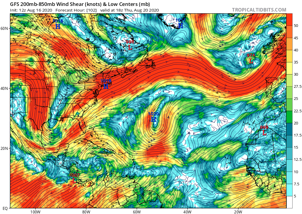
It has some negatives going against development for the next 5 days. Dry air is the issue now as seen on vis imagery. Then there looks to be an upper trough in its path NE of the Lesser Antilles if the GFS is right. Could make things pretty hostile at least for a few days. Beyond that the EPS is certainly lighting up so it could develop downstream perhaps once west or 60W:
https://i.postimg.cc/4dtsWVjn/gfs-shear-atl-18.png
Unfortunately, i am not even remotely going to listen to any model for environmental conditions or strength. and only take synoptic reasoning into consideration.. models are absolutely poppycock this year.
Now casting out 24 hours based on current conditions is the only way to go right now.
9 likes
Note: If I make a post that is brief. Please refer back to previous posts for the analysis or reasoning. I do not re-write/qoute what my initial post said each time.
If there is nothing before... then just ask
Space & Atmospheric Physicist, Embry-Riddle Aeronautical University,
I believe the sky is falling...
If there is nothing before... then just ask
Space & Atmospheric Physicist, Embry-Riddle Aeronautical University,
I believe the sky is falling...
Re: Robust Tropical Wave Along the Coast of Africa
gatorcane wrote:Aric Dunn wrote:looking at this morning's visible... I have zero doubt this will be a TC sooner rather than later.. very impressive.
It has some negatives going against development for the next 5 days. Dry air is the issue now as seen on vis imagery. Then there looks to be an upper trough in its path NE of the Lesser Antilles if the GFS is right. Could make things pretty hostile at least for a few days. Beyond that the EPS is certainly lighting up so it could develop downstream perhaps once west or 60W:
https://i.postimg.cc/4dtsWVjn/gfs-shear-atl-18.png
With the GFS keeping the MJO on the EPAC side of course is going to show hostile conditions near the Lesser Antilles.
5 likes
-
DorkyMcDorkface

- Category 5
- Posts: 1045
- Age: 28
- Joined: Mon Sep 30, 2019 1:32 pm
- Location: Mid-Atlantic
Re: Robust Tropical Wave Along the Coast of Africa
2. Another tropical wave located over the far eastern tropical
Atlantic is producing a large area of cloudiness and showers. This
wave is forecast to move westward at 15 to 20 mph during the next
few days, and some development will be possible by the middle to
latter part of the week as environmental conditions become more
conducive while the system is over the central tropical Atlantic.
* Formation chance through 48 hours...low...near 0 percent.
* Formation chance through 5 days...medium...40 percent.
4 likes
Please note the thoughts expressed by this account are solely those of the user and are from a hobbyist perspective. For more comprehensive analysis, consult an actual professional meteorologist or meteorological agency.
Floyd 1999 | Isabel 2003 | Hanna 2008 | Irene 2011 | Sandy 2012 | Isaias 2020
Re: Robust Tropical Wave Along the Coast of Africa
DorkyMcDorkface wrote:2. Another tropical wave located over the far eastern tropical
Atlantic is producing a large area of cloudiness and showers. This
wave is forecast to move westward at 15 to 20 mph during the next
few days, and some development will be possible by the middle to
latter part of the week as environmental conditions become more
conducive while the system is over the central tropical Atlantic.
* Formation chance through 48 hours...low...near 0 percent.
* Formation chance through 5 days...medium...40 percent.
They are throwing the GFS out the window and paying attention to the CMC and Euro ensembles. IMO
4 likes
-
MississippiWx

- S2K Supporter
- Posts: 1720
- Joined: Sat Aug 14, 2010 1:44 pm
- Location: Hattiesburg, Mississippi
Re: Robust Tropical Wave Along the Coast of Africa
One thing I’ve noticed this season in the MDR is the nearly constant pure westerlies. It’s no wonder everything tries to develop with such constant spin in the lower levels. The MDR, while still a bit dry, is much more moist than it was a month ago. There will probably be a time in the coming month or two where every single wave that comes off Africa develops or gives it a good shot.
The environment for this one should be better than most of the others that spawned TC’s previously.
The environment for this one should be better than most of the others that spawned TC’s previously.
1 likes
This post is not an official forecast and should not be used as such. It is just the opinion of MississippiWx and may or may not be backed by sound meteorological data. It is not endorsed by any professional institution including storm2k.org. For Official Information please refer to the NHC and NWS products.
Who is online
Users browsing this forum: No registered users and 128 guests