ATL: LAURA - Models
Moderator: S2k Moderators
-
SouthFLTropics

- Category 5

- Posts: 4258
- Age: 50
- Joined: Thu Aug 14, 2003 8:04 am
- Location: Port St. Lucie, Florida
Re: ATL: INVEST 98L - Models
That approach to FL on the 18z GFS is interesting. I'd really like to see the GFS and Euro with runs just to the North of Hispaniola and see what they may come up with. I'd guess we may see something more significant. The land interaction is definitely one of the key variables here.
1 likes
Fourth Generation Florida Native
Personal Storm History: David 79, Andrew 92, Erin 95, Floyd 99, Irene 99, Frances 04, Jeanne 04, Wilma 05, Matthew 16, Irma 17, Ian 22, Nicole 22, Milton 24
Personal Storm History: David 79, Andrew 92, Erin 95, Floyd 99, Irene 99, Frances 04, Jeanne 04, Wilma 05, Matthew 16, Irma 17, Ian 22, Nicole 22, Milton 24
-
gatorcane

- S2K Supporter

- Posts: 23708
- Age: 48
- Joined: Sun Mar 13, 2005 3:54 pm
- Location: Boca Raton, FL
Re: ATL: INVEST 98L - Models
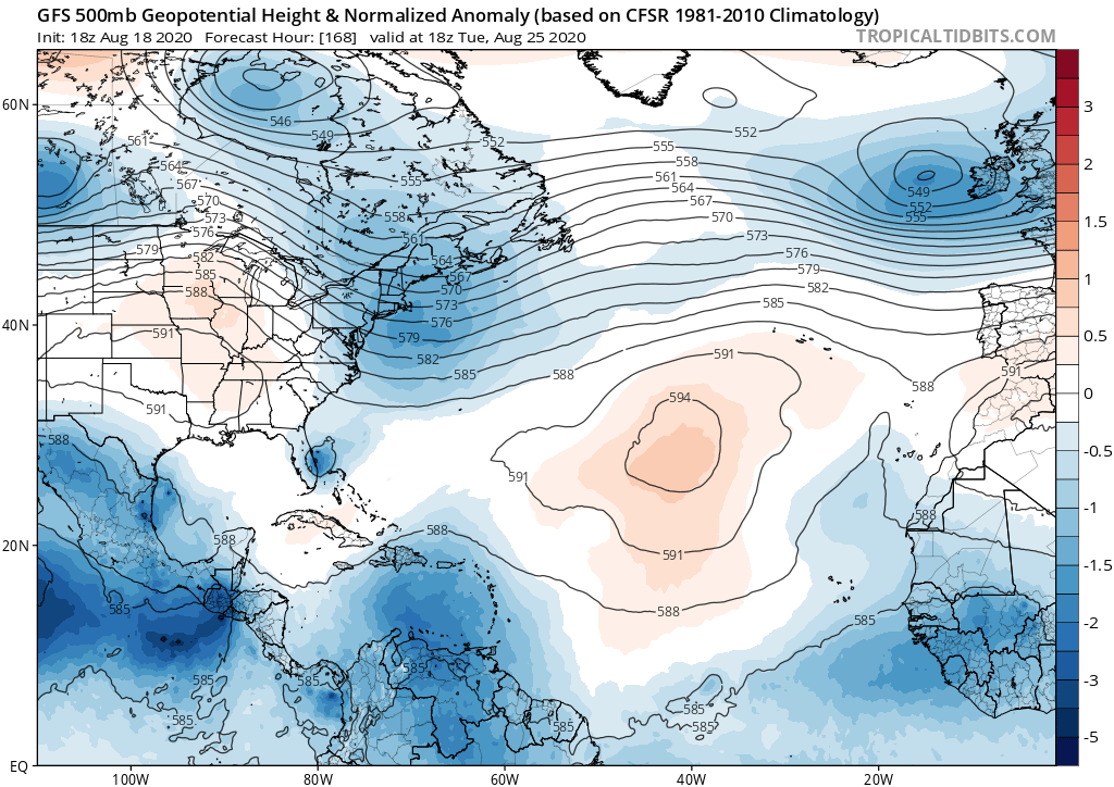
There is my trough. Even as a weak system barely hits. Euro has a completely different upper pattern though.
1 likes
-
Blown Away

- S2K Supporter
- Posts: 10253
- Joined: Wed May 26, 2004 6:17 am
Re: ATL: INVEST 98L - Models

18z GFS
0 likes
Hurricane Eye Experience: David 79, Irene 99, Frances 04, Jeanne 04, Wilma 05… Hurricane Brush Experience: Andrew 92, Erin 95, Floyd 99, Matthew 16, Irma 17, Ian 22, Nicole 22…
-
SouthFLTropics
- Category 5
- Posts: 4258
- Age: 50
- Joined: Thu Aug 14, 2003 8:04 am
- Location: Port St. Lucie, Florida
Re: ATL: INVEST 98L - Models
Ah the Happy Hour GFS decided to throw a curve ball. Gotta love that little ball of convection riding up the Space Coast and hanging out for a while.
0 likes
Fourth Generation Florida Native
Personal Storm History: David 79, Andrew 92, Erin 95, Floyd 99, Irene 99, Frances 04, Jeanne 04, Wilma 05, Matthew 16, Irma 17, Ian 22, Nicole 22, Milton 24
Personal Storm History: David 79, Andrew 92, Erin 95, Floyd 99, Irene 99, Frances 04, Jeanne 04, Wilma 05, Matthew 16, Irma 17, Ian 22, Nicole 22, Milton 24
-
supercane4867
- Category 5
- Posts: 4966
- Joined: Wed Nov 14, 2012 10:43 am
Re: ATL: INVEST 98L - Models
GFS stalls it just off shore Florida while doing a cyclonic loop before heading north to SC. LOL
0 likes
-
AutoPenalti
- Category 5
- Posts: 4091
- Age: 29
- Joined: Mon Aug 17, 2015 4:16 pm
- Location: Ft. Lauderdale, Florida
Re: ATL: INVEST 98L - Models
gatorcane wrote:There is my trough. Even as a weak system barely hits. Euro has a completely different upper pattern though.
https://i.postimg.cc/1z3H8Pmc/gfs-z500a-Norm-atl-29.png
LOL, watch it disappear at 0z.
That’s 5 runs now with little to no development from the GFS.
0 likes
The posts in this forum are NOT official forecasts and should not be used as such. They are just the opinion of the poster and may or may not be backed by sound meteorological data. They are NOT endorsed by any professional institution or STORM2K. For official information, please refer to products from the NHC and NWS.
Model Runs Cheat Sheet:
GFS (5:30 AM/PM, 11:30 AM/PM)
HWRF, GFDL, UKMET, NAVGEM (6:30-8:00 AM/PM, 12:30-2:00 AM/PM)
ECMWF (1:45 AM/PM)
TCVN is a weighted averaged
-
SouthFLTropics
- Category 5
- Posts: 4258
- Age: 50
- Joined: Thu Aug 14, 2003 8:04 am
- Location: Port St. Lucie, Florida
Re: ATL: INVEST 98L - Models
I think this GFS run shows us that if future runs avoid the big islands we could see an uptick in intensity by the GFS and Euro.
6 likes
Fourth Generation Florida Native
Personal Storm History: David 79, Andrew 92, Erin 95, Floyd 99, Irene 99, Frances 04, Jeanne 04, Wilma 05, Matthew 16, Irma 17, Ian 22, Nicole 22, Milton 24
Personal Storm History: David 79, Andrew 92, Erin 95, Floyd 99, Irene 99, Frances 04, Jeanne 04, Wilma 05, Matthew 16, Irma 17, Ian 22, Nicole 22, Milton 24
Re: ATL: INVEST 98L - Models
AutoPenalti wrote:gatorcane wrote:There is my trough. Even as a weak system barely hits. Euro has a completely different upper pattern though.
https://i.postimg.cc/1z3H8Pmc/gfs-z500a-Norm-atl-29.png
LOL, watch it disappear at 0z.
That’s 5 runs now with little to no development from the GFS.
GFS develops it significantly. I think this run bodes ill
0 likes
-
toad strangler

- S2K Supporter
- Posts: 4546
- Joined: Sun Jul 28, 2013 3:09 pm
- Location: Earth
- Contact:
Re: ATL: INVEST 98L - Models
SouthFLTropics wrote:I think this GFS run shows us that if future runs avoid the big islands we could see an uptick in intensity by the GFS and Euro.
Yeah, that's the White Elephant in the room
0 likes
My Weather Station
https://www.wunderground.com/dashboard/pws/KFLPORTS603
https://www.wunderground.com/dashboard/pws/KFLPORTS603
-
SFLcane

- S2K Supporter
- Posts: 10281
- Age: 48
- Joined: Sat Jun 05, 2010 1:44 pm
- Location: Lake Worth Florida
Re: ATL: INVEST 98L - Models
WxEp wrote:Well this is a bit different from the GFS... ridge backed off a bit compared to last run and allowed a more northerly movement after running across the Greater Antilles.
https://i.imgur.com/NVtlfNi.png
Interesting development. we shall see if it continues
0 likes
-
eastcoastFL

- Category 5
- Posts: 3996
- Age: 44
- Joined: Thu Apr 12, 2007 12:29 pm
- Location: Palm City, FL
Re: ATL: INVEST 98L - Models
supercane4867 wrote:GFS stalls it just off shore Florida while doing a cyclonic loop before heading north to SC. LOL
I may just have my dog step on a map and use that as a model for now...
3 likes
Personal Forecast Disclaimer:
The posts in this forum are NOT official forecast and should not be used as such. They are just the opinion of the poster and may or may not be backed by sound meteorological data. They are NOT endorsed by any professional institution or storm2k.org. For official information, please refer to the NHC and NWS products.
The posts in this forum are NOT official forecast and should not be used as such. They are just the opinion of the poster and may or may not be backed by sound meteorological data. They are NOT endorsed by any professional institution or storm2k.org. For official information, please refer to the NHC and NWS products.

Re: ATL: INVEST 98L - Models
chris_fit wrote:How do the 18z GFS Ens look?
The GFS-Para ensemble continues to show a concentration of members between S Fl and Cuba running thru the straits
2 likes
-
USTropics
- Professional-Met

- Posts: 2741
- Joined: Sun Aug 12, 2007 3:45 am
- Location: Florida State University
Re: ATL: INVEST 98L - Models
My favorite part of the last few GFS runs? Watch how it handles the remnants of Josephine (outlined track in blue starting 72 hours ago followed by animation):


4 likes
Re: ATL: INVEST 98L - Models
Also of note (perhaps?) HMON at 18z is trending stronger and further NE thru 87 hours
0 likes
Re: ATL: INVEST 98L - Models
sma10 wrote:Also of note (perhaps?) HMON at 18z is trending stronger and further NE thru 87 hours
Also going north of the islands as strengthening hurricane while prior run it was very weak south of PR
HWRF through 87 hours also more north. Looks like it may clip the Virgin Islands.
Last edited by caneseddy on Tue Aug 18, 2020 6:37 pm, edited 1 time in total.
0 likes
-
SouthFLTropics
- Category 5
- Posts: 4258
- Age: 50
- Joined: Thu Aug 14, 2003 8:04 am
- Location: Port St. Lucie, Florida
Re: ATL: INVEST 98L - Models
HMON is all in by hour 105. Going ballistic North of PR and headed west.
Sent from my iPhone using Tapatalk
Sent from my iPhone using Tapatalk
0 likes
Fourth Generation Florida Native
Personal Storm History: David 79, Andrew 92, Erin 95, Floyd 99, Irene 99, Frances 04, Jeanne 04, Wilma 05, Matthew 16, Irma 17, Ian 22, Nicole 22, Milton 24
Personal Storm History: David 79, Andrew 92, Erin 95, Floyd 99, Irene 99, Frances 04, Jeanne 04, Wilma 05, Matthew 16, Irma 17, Ian 22, Nicole 22, Milton 24
-
toad strangler
- S2K Supporter
- Posts: 4546
- Joined: Sun Jul 28, 2013 3:09 pm
- Location: Earth
- Contact:
Re: ATL: INVEST 98L - Models
Hmmmm

2 likes
My Weather Station
https://www.wunderground.com/dashboard/pws/KFLPORTS603
https://www.wunderground.com/dashboard/pws/KFLPORTS603
-
Blown Away
- S2K Supporter
- Posts: 10253
- Joined: Wed May 26, 2004 6:17 am
Re: ATL: INVEST 98L - Models
SouthFLTropics wrote:HMON is all in by hour 105. Going ballistic North of PR and headed west.
Sent from my iPhone using Tapatalk
Dang, goes Major and N of the GA...
0 likes
Hurricane Eye Experience: David 79, Irene 99, Frances 04, Jeanne 04, Wilma 05… Hurricane Brush Experience: Andrew 92, Erin 95, Floyd 99, Matthew 16, Irma 17, Ian 22, Nicole 22…
Who is online
Users browsing this forum: No registered users and 94 guests