ATL: LAURA - Post-Tropical - Discussion
Moderator: S2k Moderators
-
eastcoastFL

- Category 5

- Posts: 3996
- Age: 44
- Joined: Thu Apr 12, 2007 12:29 pm
- Location: Palm City, FL
Re: ATL: INVEST 98L - Discussion
It’s getting that S shape curvature
0 likes
Personal Forecast Disclaimer:
The posts in this forum are NOT official forecast and should not be used as such. They are just the opinion of the poster and may or may not be backed by sound meteorological data. They are NOT endorsed by any professional institution or storm2k.org. For official information, please refer to the NHC and NWS products.
The posts in this forum are NOT official forecast and should not be used as such. They are just the opinion of the poster and may or may not be backed by sound meteorological data. They are NOT endorsed by any professional institution or storm2k.org. For official information, please refer to the NHC and NWS products.
-
TallyTracker
- Category 2

- Posts: 787
- Joined: Thu Oct 11, 2018 2:46 pm
Re: ATL: INVEST 98L - Discussion
eastcoastFL wrote:captainbarbossa19 wrote:This is interesting. I hope this turns out not to be a good analog.
1900 Galveston Hurricane Track:
https://upload.wikimedia.org/wikipedia/commons/1/12/1900_Galveston_hurricane_track.png
Was that a cat 3?
Cat 4 with about 145 mph estimated winds.
4 likes
Fran '96, Georges '98, Gordon '00, Gabrielle '01, Charley '04, Frances '04, Jeanne '04, Barry '07, Fay '08, Debby '12, Matthew '16, Emily '17, Irma '17, Michael ‘18, Elsa ‘21, Fred ‘21, Mindy ‘21, Nicole ‘22, Idalia ‘23, Debby ‘24, Helene ‘24
-
eastcoastFL
- Category 5
- Posts: 3996
- Age: 44
- Joined: Thu Apr 12, 2007 12:29 pm
- Location: Palm City, FL
Re: ATL: INVEST 98L - Discussion
Anticyclone still in place

5 likes
Personal Forecast Disclaimer:
The posts in this forum are NOT official forecast and should not be used as such. They are just the opinion of the poster and may or may not be backed by sound meteorological data. They are NOT endorsed by any professional institution or storm2k.org. For official information, please refer to the NHC and NWS products.
The posts in this forum are NOT official forecast and should not be used as such. They are just the opinion of the poster and may or may not be backed by sound meteorological data. They are NOT endorsed by any professional institution or storm2k.org. For official information, please refer to the NHC and NWS products.

Re: ATL: INVEST 98L - Discussion
Salute!
Don't forget the Rita and Katrina and Ike tracks for soon-to-be Laura.
Gums sends...
Don't forget the Rita and Katrina and Ike tracks for soon-to-be Laura.
Gums sends...
3 likes
-
cycloneye

- Admin

- Posts: 149746
- Age: 69
- Joined: Thu Oct 10, 2002 10:54 am
- Location: San Juan, Puerto Rico
Re: ATL: INVEST 98L - Discussion
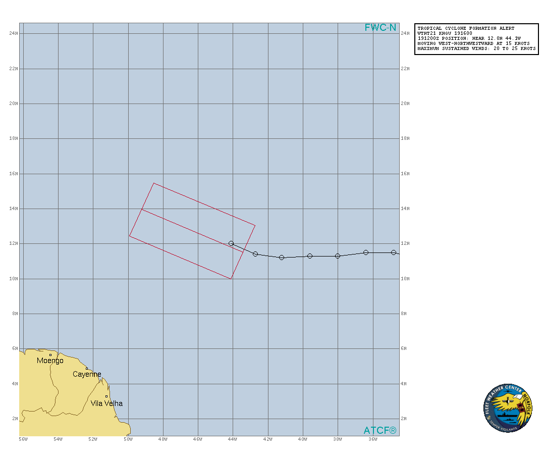
An elongated area of low pressure, located about 1000 miles east of
the Windward Islands continues to produce a concentrated area of
showers and thunderstorms. Although recent satellite-derived wind
data indicates that the low is not well-defined, environmental
conditions are conducive for further development, and a tropical
depression is expected to form during the next day or two while the
system moves generally west-northwestward at 15 to 20 mph across the
central and western portions of the tropical Atlantic. Interests
in the Lesser Antilles should monitor the progress of this system.
* Formation chance through 48 hours...high...90 percent.
* Formation chance through 5 days...high...90 percent.
0 likes
Visit the Caribbean-Central America Weather Thread where you can find at first post web cams,radars
and observations from Caribbean basin members Click Here
and observations from Caribbean basin members Click Here

Re: ATL: INVEST 98L - Discussion
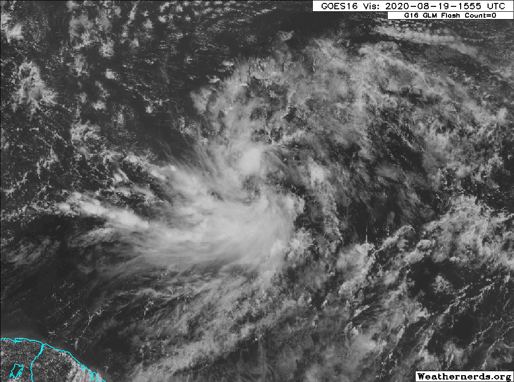
Looks to me like a MLC with a questionably attendant LLC may be located at around 12N & 45.5W. New convection popping to the north is quickly pulling NW but there's little evidence that this is close to being vertically stacked yet. Without evidence to the contrary, I'd need to see a CDO or banding features before jumping this to any TD status. Of course this would imply a bit more of a westward motion for at least another day or so.
0 likes
Andy D
(For official information, please refer to the NHC and NWS products.)
(For official information, please refer to the NHC and NWS products.)
-
SFLcane

- S2K Supporter

- Posts: 10281
- Age: 48
- Joined: Sat Jun 05, 2010 1:44 pm
- Location: Lake Worth Florida
Re: ATL: INVEST 98L - Discussion
We shall see if wxman 57's call for a PTC today comes to pass. Still disorganized per nhc.
2 likes
-
eastcoastFL
- Category 5
- Posts: 3996
- Age: 44
- Joined: Thu Apr 12, 2007 12:29 pm
- Location: Palm City, FL
Re: ATL: INVEST 98L - Discussion
chaser1 wrote:Looks to me like a MLC with a questionably attendant LLC may be located at around 12N & 45.5W. New convection popping to the north is quickly pulling NW but there's little evidence that this is close to being vertically stacked yet. Without evidence to the contrary, I'd need to see a CDO or banding features before jumping this to any TD status. Of course this would imply a bit more of a westward motion for at least another day or so.
Yup. Circulation still seems kinda broad possibly extending even a little south of 12n. Slowly but surely it’s progressing
0 likes
Personal Forecast Disclaimer:
The posts in this forum are NOT official forecast and should not be used as such. They are just the opinion of the poster and may or may not be backed by sound meteorological data. They are NOT endorsed by any professional institution or storm2k.org. For official information, please refer to the NHC and NWS products.
The posts in this forum are NOT official forecast and should not be used as such. They are just the opinion of the poster and may or may not be backed by sound meteorological data. They are NOT endorsed by any professional institution or storm2k.org. For official information, please refer to the NHC and NWS products.
-
eastcoastFL
- Category 5
- Posts: 3996
- Age: 44
- Joined: Thu Apr 12, 2007 12:29 pm
- Location: Palm City, FL
Re: ATL: INVEST 98L - Discussion
Almost euro time. Let’s see if it changes it’s mind. Nhc maybe waiting for this run to make a decision on ptc at 5pm
0 likes
Personal Forecast Disclaimer:
The posts in this forum are NOT official forecast and should not be used as such. They are just the opinion of the poster and may or may not be backed by sound meteorological data. They are NOT endorsed by any professional institution or storm2k.org. For official information, please refer to the NHC and NWS products.
The posts in this forum are NOT official forecast and should not be used as such. They are just the opinion of the poster and may or may not be backed by sound meteorological data. They are NOT endorsed by any professional institution or storm2k.org. For official information, please refer to the NHC and NWS products.
-
DestinHurricane

- Category 4

- Posts: 935
- Joined: Tue May 01, 2018 8:05 am
- Location: New York, NY
Re: ATL: INVEST 98L - Discussion
Not always but usually when NHC has 90/90 in the morning it will get an upgrade or PTC later that afternoon. We'll see if that holds true this time.
0 likes
Michael 2018
-
supercane4867
- Category 5
- Posts: 4966
- Joined: Wed Nov 14, 2012 10:43 am
-
wxman57

- Moderator-Pro Met

- Posts: 23175
- Age: 68
- Joined: Sat Jun 21, 2003 8:06 pm
- Location: Houston, TX (southwest)
Re: ATL: INVEST 98L - Discussion
DestinHurricane wrote:Not always but usually when NHC has 90/90 in the morning it will get an upgrade or PTC later that afternoon. We'll see if that holds true this time.
NHC has the criterion that they start PTC advisories if the likely storm is within 48 hrs of impacting land. In this case, it's about 50 hrs out by 4pm AST. They can start them at 4pm or wait until later when it's well within 48 hrs, possibly needing a warning shortly after. Like I said, they don't like to initiate advisories with new watches at 10pm when most people have gone to sleep. They'd rather do it a little early.
4 likes
-
SFLcane
- S2K Supporter
- Posts: 10281
- Age: 48
- Joined: Sat Jun 05, 2010 1:44 pm
- Location: Lake Worth Florida
Re: ATL: INVEST 98L - Discussion
wxman57 wrote:DestinHurricane wrote:Not always but usually when NHC has 90/90 in the morning it will get an upgrade or PTC later that afternoon. We'll see if that holds true this time.
NHC has the criterion that they start PTC advisories if the likely storm is within 48 hrs of impacting land. In this case, it's about 50 hrs out by 4pm AST. They can start them at 4pm or wait until later when it's well within 48 hrs, possibly needing a warning shortly after. Like I said, they don't like to initiate advisories with new watches at 10pm when most people have gone to sleep. They'd rather do it a little early.
So your saying by 5pm today? They might very well wait.
0 likes

Re: ATL: INVEST 98L - Discussion
That looks like it shows that the WNW movement has started?
2 likes
Igor 2010, Sandy 2012, Fay 2014, Gonzalo 2014, Joaquin 2015, Nicole 2016, Humberto 2019, Imelda 2025
I am only a tropical weather enthusiast. My predictions are not official and may or may not be backed by sound meteorological data. For official information, please refer to the NHC and NWS products.
I am only a tropical weather enthusiast. My predictions are not official and may or may not be backed by sound meteorological data. For official information, please refer to the NHC and NWS products.
-
Aric Dunn
- Category 5
- Posts: 21238
- Age: 43
- Joined: Sun Sep 19, 2004 9:58 pm
- Location: Ready for the Chase.
- Contact:
Re: ATL: INVEST 98L - Discussion
And here we go. Southerly flow on the east side has begun to increase quite steadily. low level cloud lines are more distinct in all quads.
the flux of sloutherly flow should help ignite some deep convection here shortly and bring all of this together.
the flux of sloutherly flow should help ignite some deep convection here shortly and bring all of this together.
2 likes
Note: If I make a post that is brief. Please refer back to previous posts for the analysis or reasoning. I do not re-write/qoute what my initial post said each time.
If there is nothing before... then just ask
Space & Atmospheric Physicist, Embry-Riddle Aeronautical University,
I believe the sky is falling...
If there is nothing before... then just ask
Space & Atmospheric Physicist, Embry-Riddle Aeronautical University,
I believe the sky is falling...
-
Shell Mound
- Category 5
- Posts: 2432
- Age: 33
- Joined: Thu Sep 07, 2017 3:39 pm
- Location: St. Petersburg, FL → Scandinavia
Re: ATL: INVEST 98L - Discussion
We may be fortunate in the end. The ridge on the 12Z GFS and ECMWF runs is much weaker and farther east on days three through seven, with a trend toward a stronger, west-based -NAO and northwesterly flow over the Northeastern U.S. Since 98L, like Hanna, is clearly strengthening much faster than the global models indicated, it could not only end up missing the Leeward Islands and Puerto Rico to the north, but also curve OTS between the U.S. East Coast and Bermuda after brushing the Turks and Caicos Islands. Those islands will prove to be a key benchmark. In any case, don’t become complacent if 98L ends up curving OTS as a strong hurricane, because that’s what climatology usually favours, and hyperactive seasons usually feature weaker ridges, hence fewer TUTTs, reduced VWS, and lower MSLP in the deep tropics. I really hope this ends up as a fish and generates tremendous ACE. I suspect models will trend stronger and farther NE with 98L.
Last edited by Shell Mound on Wed Aug 19, 2020 1:31 pm, edited 1 time in total.
0 likes
CVW / MiamiensisWx / Shell Mound
The posts in this forum are NOT official forecasts and should not be used as such. They are just the opinion of the poster and may or may not be backed by sound meteorological data. They are NOT endorsed by any professional institution or STORM2K. For official information, please refer to products from the NHC and NWS.
-
eastcoastFL
- Category 5
- Posts: 3996
- Age: 44
- Joined: Thu Apr 12, 2007 12:29 pm
- Location: Palm City, FL
Re: ATL: INVEST 98L - Discussion
The models are all over the place. From nothing at all forming to a Cat 3 hitting Miami on Monday or a cane in the gulf...
2 likes
Personal Forecast Disclaimer:
The posts in this forum are NOT official forecast and should not be used as such. They are just the opinion of the poster and may or may not be backed by sound meteorological data. They are NOT endorsed by any professional institution or storm2k.org. For official information, please refer to the NHC and NWS products.
The posts in this forum are NOT official forecast and should not be used as such. They are just the opinion of the poster and may or may not be backed by sound meteorological data. They are NOT endorsed by any professional institution or storm2k.org. For official information, please refer to the NHC and NWS products.
-
eastcoastFL
- Category 5
- Posts: 3996
- Age: 44
- Joined: Thu Apr 12, 2007 12:29 pm
- Location: Palm City, FL
Re: ATL: INVEST 98L - Discussion
Shell Mound wrote:We may be fortunate in the end. The ridge on the 12Z GFS and ECMWF runs is much weaker and farther east on days three through seven, with a trend toward a stronger, west-based -NAO and northwesterly flow over the Northeastern U.S. Since 98L, like Hanna, is clearly strengthening much faster than the global models indicated, it could not only end up missing the Leeward Islands and Puerto Rico to the north, but also curve OTS between the U.S. East Coast and Bermuda after brushing the Turks and Caicos Islands. Those islands will prove to be a key benchmark. In any case, don’t be complacent if 98L ends up curving OTS as a strong hurricane, because that’s what climatology usually favours, and hyperactive seasons usually feature weaker ridges, hence fewer TUTTs, reduced VWS, and lower MSLP in the deep tropics. I really hope this ends up as a fish and generates tremendous ACE. I suspect models will trend stronger and farther NE with 98L.
I saw that too. They develop the one behind this one and send it right out to sea. That’s good news
2 likes
Personal Forecast Disclaimer:
The posts in this forum are NOT official forecast and should not be used as such. They are just the opinion of the poster and may or may not be backed by sound meteorological data. They are NOT endorsed by any professional institution or storm2k.org. For official information, please refer to the NHC and NWS products.
The posts in this forum are NOT official forecast and should not be used as such. They are just the opinion of the poster and may or may not be backed by sound meteorological data. They are NOT endorsed by any professional institution or storm2k.org. For official information, please refer to the NHC and NWS products.
-
AviationWatcher
- Tropical Wave

- Posts: 2
- Joined: Wed Aug 19, 2020 10:23 am
- Location: Texas
Re: ATL: INVEST 98L - Discussion
eastcoastFL wrote:The models are all over the place. From nothing at all forming to a Cat 3 hitting Miami on Monday or a cane in the gulf...
Im new to the forums. Is it irregular to have a lot of variations in the models this far out?
2 likes
Who is online
Users browsing this forum: No registered users and 57 guests