ATL: LAURA - Post-Tropical - Discussion
Moderator: S2k Moderators
-
Evil Jeremy

- S2K Supporter

- Posts: 5463
- Age: 32
- Joined: Mon Apr 10, 2006 2:10 pm
- Location: Los Angeles, CA
Re: ATL: THIRTEEN - Tropical Depression - Discussion
I'm a bit surprised NHC jumped to TD already, I figured they would wait for the morning satellite imagery, but it makes little difference in the long run.
0 likes
Frances 04 / Jeanne 04 / Katrina 05 / Wilma 05 / Fay 08 / Debby 12 / Andrea 13 / Colin 16 / Hermine 16 / Matthew 16 / Irma 17
-
toad strangler

- S2K Supporter
- Posts: 4546
- Joined: Sun Jul 28, 2013 3:09 pm
- Location: Earth
- Contact:
Re: ATL: THIRTEEN - Tropical Depression - Discussion
StruThiO wrote:It's a bust? literally all the models but gfs and euro are busting? nhc will lower development chances because gfs and euro show no development??
i really hope we can start deleting some of these garbage posts.
Amen. Hideous.
7 likes
My Weather Station
https://www.wunderground.com/dashboard/pws/KFLPORTS603
https://www.wunderground.com/dashboard/pws/KFLPORTS603
-
CyclonicFury

- Category 5

- Posts: 2032
- Age: 27
- Joined: Sun Jul 02, 2017 12:32 pm
- Location: NC
- Contact:
Re: ATL: THIRTEEN - Tropical Depression - Discussion
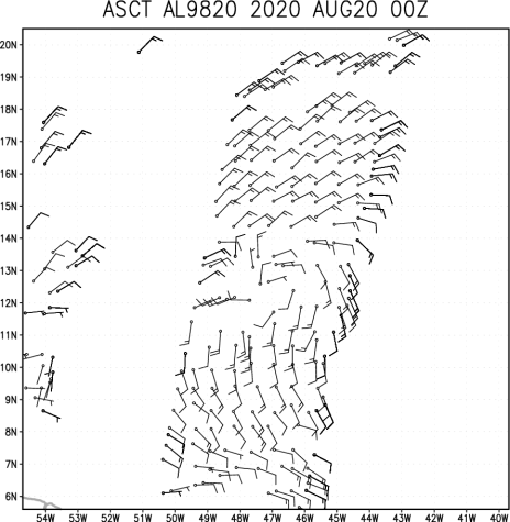
A bit surprised NHC classified this already when the recent ASCAT pass did not show any northerly winds west of the center. Going to be interesting to read the discussion and intensity forecast.
4 likes
NCSU B.S. in Meteorology Class of 2021. Tropical weather blogger at http://www.cyclonicfury.com. My forecasts and thoughts are NOT official, for official forecasts please consult the National Hurricane Center.
-
SouthFLTropics

- Category 5
- Posts: 4258
- Age: 50
- Joined: Thu Aug 14, 2003 8:04 am
- Location: Port St. Lucie, Florida
Re: ATL: INVEST 98L - Discussion
DestinHurricane wrote:AxaltaRacing24 wrote:Keldeo1997 wrote:https://twitter.com/NHC_Atlantic/status/1296271636170027009
huge win for the gfs and euro, right boys.
Not really a win/loss for any model. I don't even think the HWRF/HMON had it developing this early.
You're absolutely correct, they didn't. Not sure if that means anything but it could be ominous.
0 likes
Fourth Generation Florida Native
Personal Storm History: David 79, Andrew 92, Erin 95, Floyd 99, Irene 99, Frances 04, Jeanne 04, Wilma 05, Matthew 16, Irma 17, Ian 22, Nicole 22, Milton 24
Personal Storm History: David 79, Andrew 92, Erin 95, Floyd 99, Irene 99, Frances 04, Jeanne 04, Wilma 05, Matthew 16, Irma 17, Ian 22, Nicole 22, Milton 24
-
CrazyC83
- Professional-Met

- Posts: 34315
- Joined: Tue Mar 07, 2006 11:57 pm
- Location: Deep South, for the first time!
Re: ATL: THIRTEEN - Tropical Depression - Discussion
I didn't expect that...they must have data the rest of us don't have like an ASCAT pass that hasn't publicly been released yet.
4 likes
-
AxaltaRacing24
- Category 5
- Posts: 1774
- Age: 25
- Joined: Wed Jul 27, 2016 11:14 am
- Location: Jupiter, FL
Re: ATL: INVEST 98L - Discussion
DestinHurricane wrote:AxaltaRacing24 wrote:Keldeo1997 wrote:https://twitter.com/NHC_Atlantic/status/1296271636170027009
huge win for the gfs and euro, right boys.
Not really a win/loss for any model. I don't even think the HWRF/HMON had it developing this early.
yeah correct, but you had people saying that development into a TD was unlikely when no model shows it truly getting much stronger for another 50 hours.
3 likes
Re: ATL: THIRTEEN - Tropical Depression - Discussion
StruThiO wrote:It's a bust? literally all the models but gfs and euro are busting? nhc will lower development chances because gfs and euro show no development??
i really hope we can start deleting some of these garbage posts.
I particularly enjoyed the “lower development chances” posts every six hours the last couple days, and when it came time, they always raised the chances.
15 likes
-
eastcoastFL

- Category 5
- Posts: 3996
- Age: 44
- Joined: Thu Apr 12, 2007 12:29 pm
- Location: Palm City, FL
Re: ATL: INVEST 98L - Discussion
DestinHurricane wrote:AxaltaRacing24 wrote:Keldeo1997 wrote:https://twitter.com/NHC_Atlantic/status/1296271636170027009
huge win for the gfs and euro, right boys.
Not really a win/loss for any model. I don't even think the HWRF/HMON had it developing this early.
It say it’s still a loss all around if none of them picked up on genesis ahead of time
4 likes
Personal Forecast Disclaimer:
The posts in this forum are NOT official forecast and should not be used as such. They are just the opinion of the poster and may or may not be backed by sound meteorological data. They are NOT endorsed by any professional institution or storm2k.org. For official information, please refer to the NHC and NWS products.
The posts in this forum are NOT official forecast and should not be used as such. They are just the opinion of the poster and may or may not be backed by sound meteorological data. They are NOT endorsed by any professional institution or storm2k.org. For official information, please refer to the NHC and NWS products.
-
crownweather

- S2K Supporter
- Posts: 602
- Age: 51
- Joined: Sat Aug 12, 2006 9:21 am
- Location: Sturbridge, Massachusetts
- Contact:
Re: ATL: THIRTEEN - Tropical Depression - Discussion
toad strangler wrote:StruThiO wrote:It's a bust? literally all the models but gfs and euro are busting? nhc will lower development chances because gfs and euro show no development??
i really hope we can start deleting some of these garbage posts.
Amen. Hideous.
Seconded. The posts over the last hour have been irritating. Lots of tall weeds to wade through.
18 likes
Rob Lightbown
Crown Weather Services
https://crownweather.com
Crown Weather Services
https://crownweather.com
-
DestinHurricane

- Category 4

- Posts: 935
- Joined: Tue May 01, 2018 8:05 am
- Location: New York, NY
Re: ATL: INVEST 98L - Discussion
eastcoastFL wrote:DestinHurricane wrote:AxaltaRacing24 wrote:huge win for the gfs and euro, right boys.
Not really a win/loss for any model. I don't even think the HWRF/HMON had it developing this early.
It say it’s still a loss all around if none of them picked up on genesis ahead of time
Well then. Literally every model busted! None of them showed development this early.
It will be interesting to see what models say after they get recon out there.
Last edited by DestinHurricane on Wed Aug 19, 2020 9:32 pm, edited 1 time in total.
0 likes
Michael 2018
-
Cataegis96

- Professional-Met
- Posts: 54
- Age: 30
- Joined: Mon Jul 10, 2017 3:46 pm
- Contact:
Re: ATL: THIRTEEN - Tropical Depression - Discussion
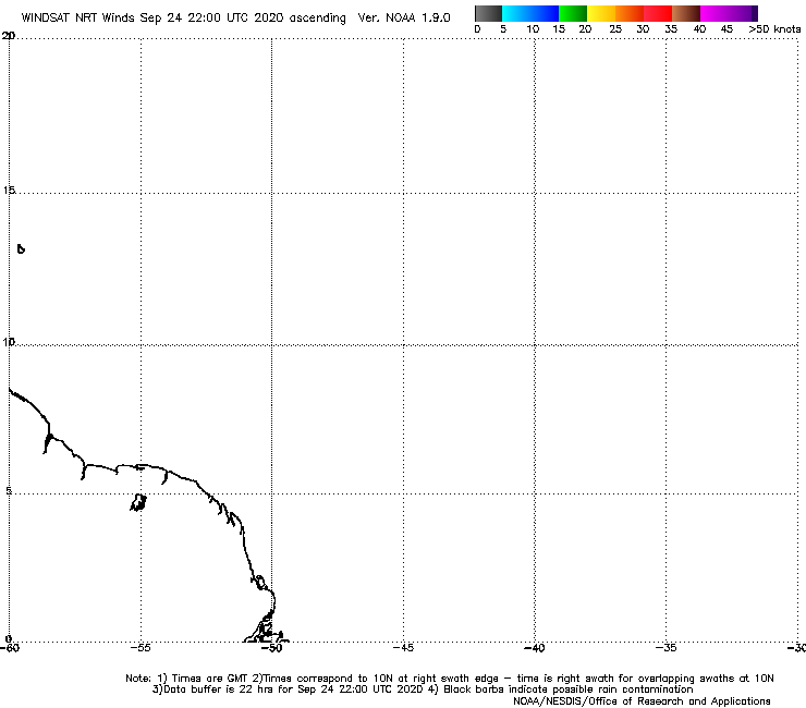
I think the NHC may have went with the WINDSAT pass.
7 likes
Lead Meteorologist Mars, Inc
WE ARE! The Pennsylvania State University 2018
UA U KNOW! University at Albany, SUNY 2020
WE ARE! The Pennsylvania State University 2018
UA U KNOW! University at Albany, SUNY 2020
-
DorkyMcDorkface

- Category 5
- Posts: 1005
- Age: 28
- Joined: Mon Sep 30, 2019 1:32 pm
- Location: Mid-Atlantic
Re: ATL: THIRTEEN - Tropical Depression - Discussion
This was posted in a Discord server I'm in, and from this is sort of does look like it's closed...?
4 likes
Please note the thoughts expressed by this account are solely those of the user and are from a hobbyist perspective. For more comprehensive analysis, consult an actual professional meteorologist or meteorological agency.
Floyd 1999 | Isabel 2003 | Hanna 2008 | Irene 2011 | Sandy 2012 | Isaias 2020
-
SouthFLTropics
- Category 5
- Posts: 4258
- Age: 50
- Joined: Thu Aug 14, 2003 8:04 am
- Location: Port St. Lucie, Florida
Re: ATL: THIRTEEN - Tropical Depression - Discussion
I hate to bring this up but since Gatorcane did earlier on the models page then I suppose it is worth mentioning again.
Go back in the archives and read some of the early discussions on the model runs for Dorian last year. Start browsing at page 15 and go from there. Eerily, they very well could be mixed in with this forum and you would think we are talking about the same storm. Freaky similarities. Not saying this is going to go all Dorian or anything but we have recent history of less than a year ago with questions in modeling of a storm very much in the same area and state.
Go back in the archives and read some of the early discussions on the model runs for Dorian last year. Start browsing at page 15 and go from there. Eerily, they very well could be mixed in with this forum and you would think we are talking about the same storm. Freaky similarities. Not saying this is going to go all Dorian or anything but we have recent history of less than a year ago with questions in modeling of a storm very much in the same area and state.
10 likes
Fourth Generation Florida Native
Personal Storm History: David 79, Andrew 92, Erin 95, Floyd 99, Irene 99, Frances 04, Jeanne 04, Wilma 05, Matthew 16, Irma 17, Ian 22, Nicole 22, Milton 24
Personal Storm History: David 79, Andrew 92, Erin 95, Floyd 99, Irene 99, Frances 04, Jeanne 04, Wilma 05, Matthew 16, Irma 17, Ian 22, Nicole 22, Milton 24
-
SFLcane

- S2K Supporter
- Posts: 10281
- Age: 48
- Joined: Sat Jun 05, 2010 1:44 pm
- Location: Lake Worth Florida
Re: ATL: THIRTEEN - Tropical Depression - Discussion
https://twitter.com/derekortt/status/12 ... 14240?s=21
epic fail by the GFS and ECMWF again this year. Never thought the models to look at would be the Canadian and ICON
epic fail by the GFS and ECMWF again this year. Never thought the models to look at would be the Canadian and ICON
5 likes
Re: ATL: THIRTEEN - Tropical Depression - Discussion
CyclonicFury wrote:A bit surprised NHC classified this already when the recent ASCAT pass did not show any northerly winds west of the center. Going to be interesting to read the discussion and intensity forecast.
Yes looking forward to this discussion. Obviously, they will mention the great disparity between the GFS/EURO (dissipation) and the hurricane models (major hurricane), but am most interested in how they sort out their specific 120 hr forecast. Certainly they cannot mirror the HWRF solution of a 130kt hurricane over Dade County; yet they are also not going to forecast a dissipated remnant low. My guess -- they will split the difference and put it around Andros Island at 55-65 knots
3 likes
-
DorkyMcDorkface
- Category 5
- Posts: 1005
- Age: 28
- Joined: Mon Sep 30, 2019 1:32 pm
- Location: Mid-Atlantic
Re: ATL: THIRTEEN - Tropical Depression - Discussion
2 likes
Please note the thoughts expressed by this account are solely those of the user and are from a hobbyist perspective. For more comprehensive analysis, consult an actual professional meteorologist or meteorological agency.
Floyd 1999 | Isabel 2003 | Hanna 2008 | Irene 2011 | Sandy 2012 | Isaias 2020
-
AxaltaRacing24
- Category 5
- Posts: 1774
- Age: 25
- Joined: Wed Jul 27, 2016 11:14 am
- Location: Jupiter, FL
Re: ATL: THIRTEEN - Tropical Depression - Discussion
SFLcane wrote:https://twitter.com/derekortt/status/1296273966991114240?s=21
epic fail by the GFS and ECMWF again this year. Never thought the models to look at would be the Canadian and ICON
the cmc and icon were 2 of the models that picked all this stuff up first.
1 likes
Re: ATL: THIRTEEN - Tropical Depression - Discussion
If they go with TVCN, the forecast track will end up near/over the keys.
0 likes
-
DestinHurricane
- Category 4
- Posts: 935
- Joined: Tue May 01, 2018 8:05 am
- Location: New York, NY
Re: ATL: THIRTEEN - Tropical Depression - Discussion
sma10 wrote:CyclonicFury wrote:A bit surprised NHC classified this already when the recent ASCAT pass did not show any northerly winds west of the center. Going to be interesting to read the discussion and intensity forecast.
Yes looking forward to this discussion. Obviously, they will mention the great disparity between the GFS/EURO (dissipation) and the hurricane models (major hurricane), but am most interested in how they sort out their specific 120 hr forecast. Certainly they cannot mirror the HWRF solution of a 130kt hurricane over Dade County; yet they are also not going to forecast a dissipated remnant low. My guess -- they will split the difference and put it around Andros Island at 55-65 knots
Typically they follow the intensity consensus pretty close but don't know if they will this time as it's at cat 3.
0 likes
Michael 2018

Who is online
Users browsing this forum: No registered users and 10 guests