ATL: LAURA - Models
Moderator: S2k Moderators
-
Blown Away

- S2K Supporter

- Posts: 10253
- Joined: Wed May 26, 2004 6:17 am
Re: ATL: THIRTEEN - Models
This morning's models are of concern, but the Florida "Magic Trap" door may be slightly opening, just a little. 
2 likes
Hurricane Eye Experience: David 79, Irene 99, Frances 04, Jeanne 04, Wilma 05… Hurricane Brush Experience: Andrew 92, Erin 95, Floyd 99, Matthew 16, Irma 17, Ian 22, Nicole 22…
-
chris_fit

- Category 5

- Posts: 3261
- Age: 43
- Joined: Wed Sep 10, 2003 11:58 pm
- Location: Tampa Bay Area, FL
Re: ATL: THIRTEEN - Models
stormlover2013 wrote:Navy lol
Let's put some beef/info behind a post like that please...

3 likes
-
toad strangler

- S2K Supporter
- Posts: 4546
- Joined: Sun Jul 28, 2013 3:09 pm
- Location: Earth
- Contact:
Re: ATL: THIRTEEN - Models
Blown Away wrote:This morning's models are of concern, but the Florida "Magic Trap" door may be slightly opening, just a little.
That trap door is ALWAYS on the table with this type of track. It's standard SW Atlantic Basin climatology.
Last edited by toad strangler on Thu Aug 20, 2020 7:53 am, edited 1 time in total.
7 likes
My Weather Station
https://www.wunderground.com/dashboard/pws/KFLPORTS603
https://www.wunderground.com/dashboard/pws/KFLPORTS603
-
SFLcane

- S2K Supporter
- Posts: 10281
- Age: 48
- Joined: Sat Jun 05, 2010 1:44 pm
- Location: Lake Worth Florida
Re: ATL: THIRTEEN - Models
Blown Away wrote:This morning's models are of concern, but the Florida "Magic Trap" door may be slightly opening, just a little.
Though our secret door is always open i don't see any strong signal yet.
0 likes

Re: ATL: THIRTEEN - Models
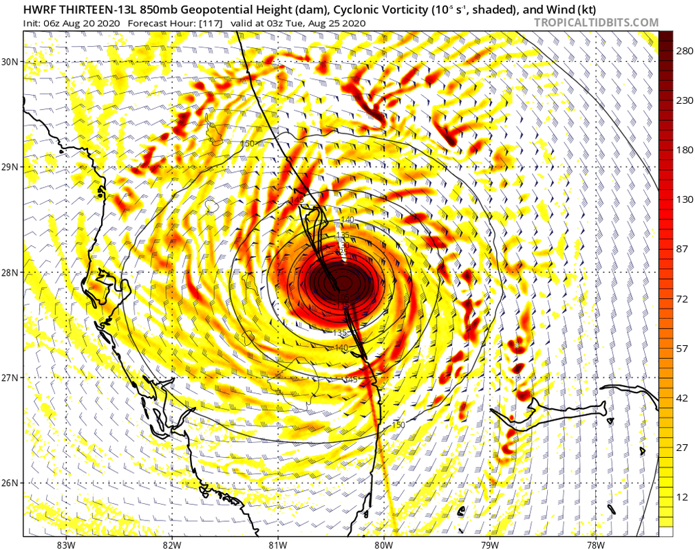
Shell Mound wrote:gatorcane wrote:06Z HWRF misses South Florida completely:
https://i.postimg.cc/Tw670NMk/hwrf-z850-vort-13-L-40.png
The track and intensity is very similar to that of Matthew (2016), since it traverses the passage between PBI and Freeport as a Category-4+ TC.
Similar but totally different at the same time. The Bermuda ridge didn't extend that far west and it was weaker than what is forecasted with TD 13.

0 likes
-
TallyTracker
- Category 2

- Posts: 787
- Joined: Thu Oct 11, 2018 2:46 pm
Re: ATL: THIRTEEN - Models
06z GFS got my attention!  It sends a solid Cat 1 hurricane due north into Apalachee Bay and straight across Tallahassee. That would be both devastating wind wise (Tally is known for it’s massive oak trees) and the surge would be massive at the coast.
0 likes
Fran '96, Georges '98, Gordon '00, Gabrielle '01, Charley '04, Frances '04, Jeanne '04, Barry '07, Fay '08, Debby '12, Matthew '16, Emily '17, Irma '17, Michael ‘18, Elsa ‘21, Fred ‘21, Mindy ‘21, Nicole ‘22, Idalia ‘23, Debby ‘24, Helene ‘24
-
DestinHurricane

- Category 4

- Posts: 935
- Joined: Tue May 01, 2018 8:05 am
- Location: New York, NY
Re: ATL: THIRTEEN - Models
TallyTracker wrote:06z GFS got my attention!
A lot of the big oaks around there already fell. That would be very bad for areas still recovering. Also that's probably a cat 2 at 979.
2 likes
Michael 2018
-
AutoPenalti
- Category 5
- Posts: 4091
- Age: 29
- Joined: Mon Aug 17, 2015 4:16 pm
- Location: Ft. Lauderdale, Florida
Re: ATL: THIRTEEN - Models
SFLcane wrote:EPS 06z is a ghost town..then again it has always been lol.
I'd give it until 12z to see where it's at.
0 likes
The posts in this forum are NOT official forecasts and should not be used as such. They are just the opinion of the poster and may or may not be backed by sound meteorological data. They are NOT endorsed by any professional institution or STORM2K. For official information, please refer to products from the NHC and NWS.
Model Runs Cheat Sheet:
GFS (5:30 AM/PM, 11:30 AM/PM)
HWRF, GFDL, UKMET, NAVGEM (6:30-8:00 AM/PM, 12:30-2:00 AM/PM)
ECMWF (1:45 AM/PM)
TCVN is a weighted averaged

Re: ATL: THIRTEEN - Models
I haven't seen 06z euro myself, but if it's really as empty as is being suggested in this topic, I can't remember the last time there has been such a huge disparity between the euro (or any single major model) and all the other ones. I'm inclined to think that it has to do with the lack of data of the region due to covid-19, but could there be anything else you can think of that can cause such a big difference between a model basically showing nothing and all the others showing (major) hurricanes?
4 likes

Re: ATL: THIRTEEN - Models
I prefer to be in the cone early on just to wait it out and be out of it like usual from our last few threats.
3 likes
-
TheStormExpert
Re: ATL: THIRTEEN - Models
boca wrote:I prefer to be in the cone early on just to wait it out and be out of it like usual from our last few threats.
Don’t get too complacent! We’re going to get hit one of these days.
3 likes
-
eastcoastFL

- Category 5
- Posts: 3996
- Age: 44
- Joined: Thu Apr 12, 2007 12:29 pm
- Location: Palm City, FL
Re: ATL: THIRTEEN - Models
0 likes
Personal Forecast Disclaimer:
The posts in this forum are NOT official forecast and should not be used as such. They are just the opinion of the poster and may or may not be backed by sound meteorological data. They are NOT endorsed by any professional institution or storm2k.org. For official information, please refer to the NHC and NWS products.
The posts in this forum are NOT official forecast and should not be used as such. They are just the opinion of the poster and may or may not be backed by sound meteorological data. They are NOT endorsed by any professional institution or storm2k.org. For official information, please refer to the NHC and NWS products.
-
DestinHurricane
- Category 4
- Posts: 935
- Joined: Tue May 01, 2018 8:05 am
- Location: New York, NY
Re: ATL: THIRTEEN - Models
Not sure I buy the Matthew analogs. This setup reminds me more of Andrew.
Keep in mind that Matthew happened in October when throughs are stronger and send storms more poleward. This is august and we don't even have a trough.
Keep in mind that Matthew happened in October when throughs are stronger and send storms more poleward. This is august and we don't even have a trough.
Last edited by DestinHurricane on Thu Aug 20, 2020 8:18 am, edited 1 time in total.
4 likes
Michael 2018
-
eastcoastFL
- Category 5
- Posts: 3996
- Age: 44
- Joined: Thu Apr 12, 2007 12:29 pm
- Location: Palm City, FL
Re: ATL: THIRTEEN - Models
CMC looks further north too

0 likes
Personal Forecast Disclaimer:
The posts in this forum are NOT official forecast and should not be used as such. They are just the opinion of the poster and may or may not be backed by sound meteorological data. They are NOT endorsed by any professional institution or storm2k.org. For official information, please refer to the NHC and NWS products.
The posts in this forum are NOT official forecast and should not be used as such. They are just the opinion of the poster and may or may not be backed by sound meteorological data. They are NOT endorsed by any professional institution or storm2k.org. For official information, please refer to the NHC and NWS products.


-
tolakram
- Admin

- Posts: 20173
- Age: 62
- Joined: Sun Aug 27, 2006 8:23 pm
- Location: Florence, KY (name is Mark)
Re: ATL: THIRTEEN - Models
DestinHurricane wrote:Not sure I buy the Matthew analogs. This setup reminds me more of Andrew.
Keep in mind that Matthew happened in October when throughs are stronger and send storms more poleward. This is august and we don't even have a trough.
Andrew moved NW before bending back west. Why does this remind you of Andrew?
3 likes
M a r k
- - - - -
Join us in chat: Storm2K Chatroom Invite. Android and IOS apps also available.
The posts in this forum are NOT official forecasts and should not be used as such. Posts are NOT endorsed by any professional institution or STORM2K.org. For official information and forecasts, please refer to NHC and NWS products.

-
DestinHurricane
- Category 4
- Posts: 935
- Joined: Tue May 01, 2018 8:05 am
- Location: New York, NY
Re: ATL: THIRTEEN - Models
tolakram wrote:DestinHurricane wrote:Not sure I buy the Matthew analogs. This setup reminds me more of Andrew.
Keep in mind that Matthew happened in October when throughs are stronger and send storms more poleward. This is august and we don't even have a trough.
Andrew moved NW before bending back west. Why does this remind you of Andrew?
I mean on approach to landfall it reminds me more of Andrew with the ridge being above it. Sort of like Rita too in this area IIRC. Katrina too for the first landfall. No through to pull it N.
0 likes
Michael 2018
Who is online
Users browsing this forum: No registered users and 33 guests