ATL: LAURA - Models

Moderator: S2k Moderators

Message
Author
User avatar
Steve
S2K Supporter
S2K Supporter
Posts: 9621
Joined: Sat Apr 05, 2003 11:41 pm
Location: Not a state-caster

Re: ATL: THIRTEEN - Models

#1501 Postby Steve » Thu Aug 20, 2020 11:59 pm

SoupBone wrote:


Any sound reasoning why the ICON would favor 13 over 14?


Land interaction. So far it's GFS vs. ICON, CMC (prior runs of other models).
0 likes   

User avatar
Janie2006
Category 5
Category 5
Posts: 1329
Joined: Mon Sep 18, 2006 3:28 pm
Location: coastal Ms aka home of the hurricanes

Re: ATL: THIRTEEN - Models

#1502 Postby Janie2006 » Fri Aug 21, 2020 12:09 am

I don’t get too caught up in the models at this stage of the game, I’m just watching for trends at the moment. A landfall at Dauphin Island or (more likely right now) Pensacola or Destin seems like a good bet, but we’re all just getting caught up in it like we always do. :)
2 likes   

User avatar
Hypercane_Kyle
Category 5
Category 5
Posts: 3354
Joined: Sat Mar 07, 2015 7:58 pm
Location: Cape Canaveral, FL

Re: ATL: THIRTEEN - Models

#1503 Postby Hypercane_Kyle » Fri Aug 21, 2020 12:10 am

I believe I saw it mentioned on Twitter that the 00z hurricane models would be the ones with actual recon data in them, so this HWRF run will be one to pay attention to.
1 likes   
My posts are my own personal opinion, defer to the National Hurricane Center (NHC) and other NOAA products for decision making during hurricane season.

User avatar
AtlanticWind
S2K Supporter
S2K Supporter
Posts: 1890
Age: 66
Joined: Sun Aug 08, 2004 9:57 pm
Location: Plantation,Fla

Re: ATL: THIRTEEN - Models

#1504 Postby AtlanticWind » Fri Aug 21, 2020 12:17 am

HWRF stronger and a little further north

https://www.tropicaltidbits.com/analysi ... 2100&fh=48
0 likes   

AutoPenalti
Category 5
Category 5
Posts: 4030
Age: 29
Joined: Mon Aug 17, 2015 4:16 pm
Location: Ft. Lauderdale, Florida

Re: ATL: THIRTEEN - Models

#1505 Postby AutoPenalti » Fri Aug 21, 2020 12:18 am

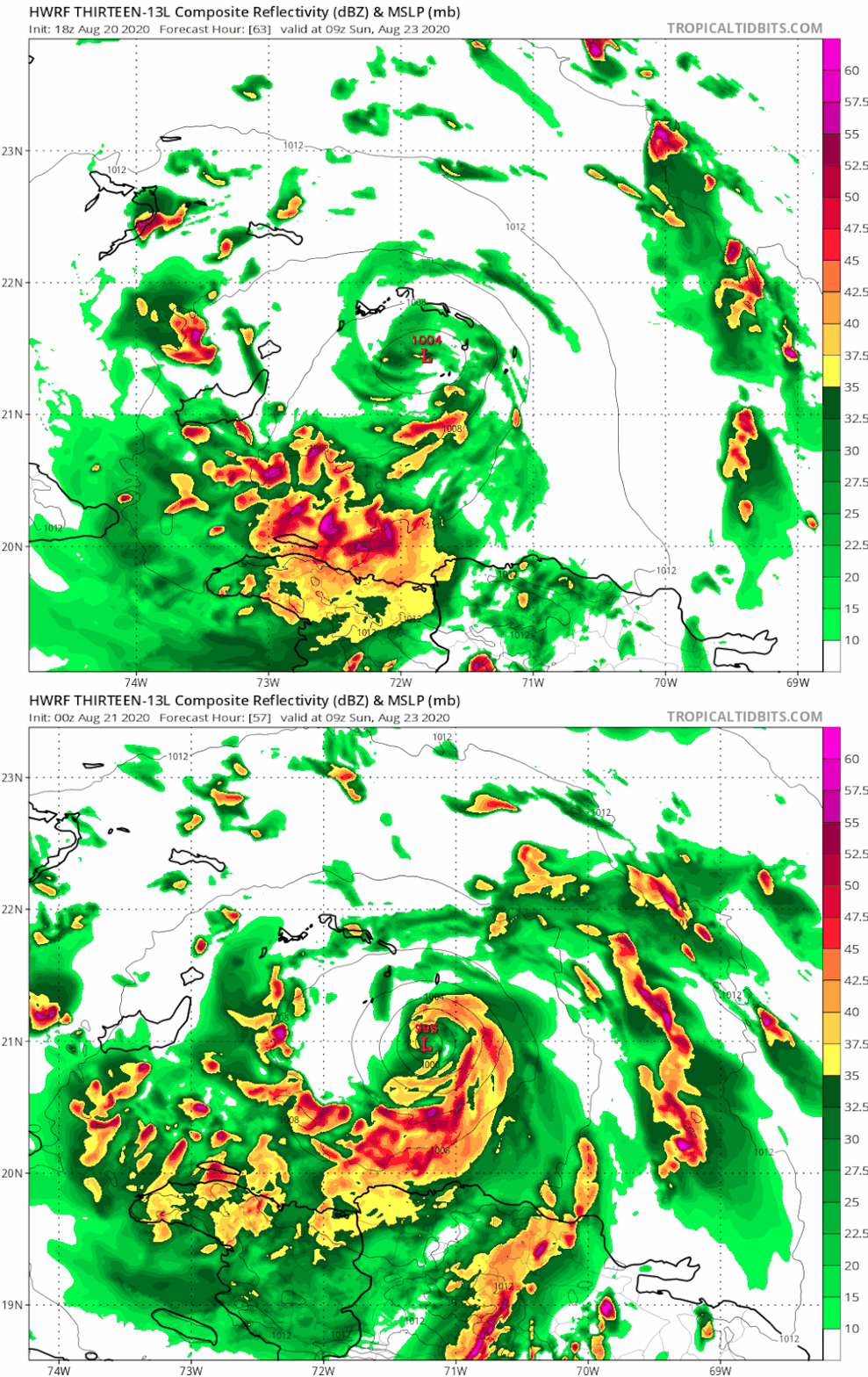
HWRF 00z (21st) vs 18z (20th)


Image

Stronger and further south.
2 likes   
The posts in this forum are NOT official forecasts and should not be used as such. They are just the opinion of the poster and may or may not be backed by sound meteorological data. They are NOT endorsed by any professional institution or STORM2K. For official information, please refer to products from the NHC and NWS.


Model Runs Cheat Sheet:
GFS (5:30 AM/PM, 11:30 AM/PM)
HWRF, GFDL, UKMET, NAVGEM (6:30-8:00 AM/PM, 12:30-2:00 AM/PM)
ECMWF (1:45 AM/PM)

TCVN
is a weighted averaged

User avatar
Steve
S2K Supporter
S2K Supporter
Posts: 9621
Joined: Sat Apr 05, 2003 11:41 pm
Location: Not a state-caster

Re: ATL: THIRTEEN - Models

#1506 Postby Steve » Fri Aug 21, 2020 12:19 am

Hypercane_Kyle wrote:I believe I saw it mentioned on Twitter that the 00z hurricane models would be the ones with actual recon data in them, so this HWRF run will be one to pay attention to.


It's slightly north of Hispaniola whereas the HMON crosses it directly over the island and Puerto Rico having it scrambled after that. HWRF looks stronger. Both hurricane models are fairly strong with TD #14 coming off the Yucatan (HWRF = 982 at about 22.5N and HMON = 980mb around 25.3N.

Who knows. It's going to be fun to watch though to see if these runs end up with a stronger 14 or 13 and which side the hurricane models will line up on as far as which system they think is going to be stronger.
0 likes   

User avatar
StPeteMike
Category 2
Category 2
Posts: 631
Joined: Thu Jun 07, 2018 11:26 pm

Re: ATL: THIRTEEN - Models

#1507 Postby StPeteMike » Fri Aug 21, 2020 12:35 am

AtlanticWind wrote:HWRF stronger and a little further north

https://www.tropicaltidbits.com/analysi ... 2100&fh=48

Unfortunately the models have been increasing intensity approaching SFL during the past day, excluding the GFS and EURO, though I’ll expect one of them to buck their trend and align with the majority of the models into Friday. That said, I still wouldn’t rule out a major through the straits or SFL.
0 likes   
The above post is not official and should not be used as such. It is the opinion of the poster and may or may not be backed by sound meteorological data. It is not endorsed by any professional institution or storm2k.org. For official information, please refer to the NHC and NWS products.

Keldeo1997
Category 2
Category 2
Posts: 637
Joined: Fri Oct 11, 2019 11:35 pm

Re: ATL: THIRTEEN - Models

#1508 Postby Keldeo1997 » Fri Aug 21, 2020 12:44 am

Image

Well it looks like the Recon data made the HWRF even more bullish. 140 MPH CAT 4 landfall in Key West moving NW into the gulf
3 likes   

User avatar
ColdMiser123
Professional-Met
Professional-Met
Posts: 904
Age: 29
Joined: Mon Sep 26, 2016 3:26 pm
Location: Northeast US

Re: ATL: THIRTEEN - Models

#1509 Postby ColdMiser123 » Fri Aug 21, 2020 12:53 am

Euro a good bit stronger through hour 24.
0 likes   
B.S., M.S., Meteorology & Atmospheric Science

User avatar
Steve
S2K Supporter
S2K Supporter
Posts: 9621
Joined: Sat Apr 05, 2003 11:41 pm
Location: Not a state-caster

Re: ATL: THIRTEEN - Models

#1510 Postby Steve » Fri Aug 21, 2020 1:01 am

https://www.tropicaltidbits.com/analysi ... 100&fh=102

Bad news for even more people if HWRF verifies. We'll have back to back hits with a Cat 2 in Louisiana and who knows what we're going to get out of TD #13? HWRF hits the FL Straits and then is heading NW up toward the North Central Gulf in the 940's. Again, that's legit > 100mph sustained. FL? AL? MS? LA x 2? There are still plots outstanding for another 24 hours, so maybe it will indicate what it's going to do in the next 10-15 minutes so I can go to bed.
0 likes   

WxEp
Tropical Depression
Tropical Depression
Posts: 71
Joined: Sat Sep 14, 2019 2:34 pm

Re: ATL: THIRTEEN - Models

#1511 Postby WxEp » Fri Aug 21, 2020 1:03 am

ColdMiser123 wrote:Euro a good bit stronger through hour 24.


Appears to be stronger at that point than it has been since the Aug 18 00z run (not that that is saying much).

Between H24 and H48 it weakens but it's still relatively stronger than recent previous runs for what it's worth.
0 likes   
The posts in this forum are NOT official forecast and should not be used as such. They are just the opinion of the poster and may or may not be backed by sound meteorological data. They are NOT endorsed by any professional institution or STORM2K. For official information, refer to products from the National Hurricane Center and National Weather Service.

User avatar
Steve
S2K Supporter
S2K Supporter
Posts: 9621
Joined: Sat Apr 05, 2003 11:41 pm
Location: Not a state-caster

Re: ATL: THIRTEEN - Models

#1512 Postby Steve » Fri Aug 21, 2020 1:07 am

HWRF with 6 hours to go has people in AL and MS staring at a 942 beast cane. 2 more plots to go.
https://www.tropicaltidbits.com/analysi ... 13L_40.png

Image
0 likes   

Shell Mound
Category 5
Category 5
Posts: 2434
Age: 32
Joined: Thu Sep 07, 2017 3:39 pm
Location: St. Petersburg, FL → Scandinavia

Re: ATL: THIRTEEN - Models

#1513 Postby Shell Mound » Fri Aug 21, 2020 1:12 am

Image

HWRF shows a rapidly intensifying Category-4+ TC moving WNW through the Keys and/or South FL. This run strikes Key West head on.
0 likes   
CVW / MiamiensisWx / Shell Mound
The posts in this forum are NOT official forecasts and should not be used as such. They are just the opinion of the poster and may or may not be backed by sound meteorological data. They are NOT endorsed by any professional institution or STORM2K. For official information, please refer to products from the NHC and NWS.

User avatar
Steve
S2K Supporter
S2K Supporter
Posts: 9621
Joined: Sat Apr 05, 2003 11:41 pm
Location: Not a state-caster

Re: ATL: THIRTEEN - Models

#1514 Postby Steve » Fri Aug 21, 2020 1:13 am

Final plot. Trajectory is toward Jackson County, Mississippi at 938. We're getting into very strong Cat 3 levels there and possibly close to Cat 4. Since HWRF is the only model so far (EC pending and I'm not staying up) that intensifies both systems at these levels, I'm inclined to believe it less. GFS, HMON like 14; ICON, CMC like 13; HWRF likes them both but particularly 13. See y'all tomorrow.

Image
Last edited by Steve on Fri Aug 21, 2020 1:14 am, edited 1 time in total.
1 likes   

Keldeo1997
Category 2
Category 2
Posts: 637
Joined: Fri Oct 11, 2019 11:35 pm

Re: ATL: THIRTEEN - Models

#1515 Postby Keldeo1997 » Fri Aug 21, 2020 1:14 am

Last frame of HWRF has a strengthening CAT 4 heading for Mobile Bay

Image

Image
2 likes   

User avatar
Steve
S2K Supporter
S2K Supporter
Posts: 9621
Joined: Sat Apr 05, 2003 11:41 pm
Location: Not a state-caster

Re: ATL: THIRTEEN - Models

#1516 Postby Steve » Fri Aug 21, 2020 1:17 am

^^ I got it going past there toward Pascagoula or maybe Ocean Springs. But not talking much difference there.
0 likes   

Shell Mound
Category 5
Category 5
Posts: 2434
Age: 32
Joined: Thu Sep 07, 2017 3:39 pm
Location: St. Petersburg, FL → Scandinavia

Re: ATL: THIRTEEN - Models

#1517 Postby Shell Mound » Fri Aug 21, 2020 1:18 am


Trajectory and intensity is like a stronger blend of Frederic (1979) and Georges (1998).
1 likes   
CVW / MiamiensisWx / Shell Mound
The posts in this forum are NOT official forecasts and should not be used as such. They are just the opinion of the poster and may or may not be backed by sound meteorological data. They are NOT endorsed by any professional institution or STORM2K. For official information, please refer to products from the NHC and NWS.

User avatar
ColdMiser123
Professional-Met
Professional-Met
Posts: 904
Age: 29
Joined: Mon Sep 26, 2016 3:26 pm
Location: Northeast US

Re: ATL: THIRTEEN - Models

#1518 Postby ColdMiser123 » Fri Aug 21, 2020 1:22 am

WxEp wrote:
ColdMiser123 wrote:Euro a good bit stronger through hour 24.


Appears to be stronger at that point than it has been since the Aug 18 00z run (not that that is saying much).

Between H24 and H48 it weakens but it's still relatively stronger than recent previous runs for what it's worth.


These are some pretty significant changes still in the short-term on the Euro.

This ultimately may have more significant forecast implications down the road if this continues to take place with future runs.

Image
1 likes   
B.S., M.S., Meteorology & Atmospheric Science

User avatar
Blinhart
Category 5
Category 5
Posts: 2081
Age: 48
Joined: Thu Sep 08, 2011 3:13 pm
Location: Crowley, La.

Re: ATL: THIRTEEN - Models

#1519 Postby Blinhart » Fri Aug 21, 2020 1:35 am

Looks like my area will be trying to dodge 2 separate bullets within 72-96 hours of each other, hoping neither get too strong and miss this area. Not wishing a strong system to hit anyone or for 2 systems to hit the same area at all. But the way 2020 is going there is a small chance the same place might get hit by 2 majors within one week, that would be devastating.
2 likes   
Personal Forecast Disclaimer:
The posts in this forum are NOT official forecast and should not be used as such. They are just the opinion of the poster and may or may not be backed by sound meteorological data. They are NOT endorsed by any professional institution or storm2k.org. For official information, please refer to the NHC and NWS products.

Shell Mound
Category 5
Category 5
Posts: 2434
Age: 32
Joined: Thu Sep 07, 2017 3:39 pm
Location: St. Petersburg, FL → Scandinavia

Re: ATL: THIRTEEN - Models

#1520 Postby Shell Mound » Fri Aug 21, 2020 1:44 am

ColdMiser123 wrote:
WxEp wrote:
ColdMiser123 wrote:Euro a good bit stronger through hour 24.


Appears to be stronger at that point than it has been since the Aug 18 00z run (not that that is saying much).

Between H24 and H48 it weakens but it's still relatively stronger than recent previous runs for what it's worth.


These are some pretty significant changes still in the short-term on the Euro.

This ultimately may have more significant forecast implications down the road if this continues to take place with future runs.

https://i.imgur.com/AQykUgX.gif

So far models have distinctly trended toward a stronger and more westerly trajectory with both TD Thirteen and TD Fourteen.

If Fourteen is farther W in the GoM while Thirteen nears S FL, then there may be sufficient “space” to support two strong ‘canes.

The big takeaway is that the ridge has continued to become stronger with each passing run, so stronger systems still head W(NW).

Personally, I don’t think the latest HWRF solutions are so implausible as far as intensity goes (I side with the EPS for 500-mb setup).
1 likes   
CVW / MiamiensisWx / Shell Mound
The posts in this forum are NOT official forecasts and should not be used as such. They are just the opinion of the poster and may or may not be backed by sound meteorological data. They are NOT endorsed by any professional institution or STORM2K. For official information, please refer to products from the NHC and NWS.


Return to “2020”

Who is online

Users browsing this forum: No registered users and 6 guests