ATL: LAURA - Post-Tropical - Discussion
Moderator: S2k Moderators
-
invest man
- Tropical Storm

- Posts: 209
- Joined: Sun Aug 17, 2008 8:12 pm
Re: ATL: THIRTEEN - Tropical Depression - Discussion
Got a question for those in the know. This may be a question that belongs somewhere else but here goes. Just read an article about the possibility that both 13 and 14 may come together as 1 possibly while both are in the northern Gulf. They kind of made it out that this could be a type of “perfect storm” like the one that hit the NE area a few years back that the movie was based upon. Question is, is this a possibility and if so is there any model that shows this set up and then where would it go after landfall? Article used a couple of storms that did this in the pacific a few years back. I’ve never seen this happen with 2 hurricanes or even TS’s in the Atlantic. Sorry mods if this is the wrong place to ask this question.
0 likes
-
cp79
Re: ATL: THIRTEEN - Tropical Depression - Discussion
The only way I see this surviving is if the center can form on the north side of the convection as the HWRF is suggesting. If it’s lower down, it’s gonna get eaten up by Hispaniola. Model-wise, def a battle between Euro and HWRF as the two extremes. Euro has been killing it from day 1 while HWRF seems to be the most bullish.
0 likes
Re: ATL: THIRTEEN - Tropical Depression - Discussion
cp79 wrote:The only way I see this surviving is if the center can form on the north side of the convection as the HWRF is suggesting. If it’s lower down, it’s gonna get eaten up by Hispaniola. Model-wise, def a battle between Euro and HWRF as the two extremes. Euro has been killing it from day 1 while HWRF seems to be the most bullish.
HWRF seems to have the best handle on it so far of any model
5 likes
-
SFLcane

- S2K Supporter

- Posts: 10281
- Age: 48
- Joined: Sat Jun 05, 2010 1:44 pm
- Location: Lake Worth Florida
Re: ATL: THIRTEEN - Tropical Depression - Discussion
NDG wrote:Should see an upgrade.
URNT12 KWBC 211220
VORTEX DATA MESSAGE AL132020
A. 21/12:00:13Z
B. 16.70 deg N 059.51 deg W
C. 850 MB 1523 m
D. 1011 mb
E. 247 deg 17 kt
F. NA
G. NA
H. 41 kt
I. 014 deg 130 nm 11:23:08Z
J. 111 deg 42 kt
K. 011 deg 161 nm 11:14:13Z
L. 33 kt
M. 206 deg 6 nm 12:01:55Z
N. 206 deg 13 kt
O. 207 deg 9 nm 12:02:42Z
P. 17 C / 1537 m
Q. 21 C / 1523 m
R. 10 C / NA
S. 13 / 8
T. 0.01 / 7 nm
U. NOAA2 0213A CYCLONE OB 06
MAX FL WIND 42 KT 011 / 161 NM 11:14:13Z
MAX FL TEMP 24 C 354 / 30 NM FROM FL CNTR
More then likely yes.. And again a little ahead of model guidance if you asked me.
0 likes
-
MarioProtVI
- Category 5

- Posts: 1034
- Age: 24
- Joined: Sun Sep 29, 2019 7:33 pm
- Location: New Jersey
Re: ATL: THIRTEEN - Tropical Depression - Discussion
13L THIRTEEN 200821 1200 17.0N 59.5W ATL 40 1008
We have Laura.
We have Laura.
5 likes
-
Extratropical94

- Professional-Met

- Posts: 3545
- Age: 31
- Joined: Wed Oct 20, 2010 6:36 am
- Location: Hamburg, Germany
- Contact:
Re: ATL: THIRTEEN - Tropical Depression - Discussion
invest man wrote:Got a question for those in the know. This may be a question that belongs somewhere else but here goes. Just read an article about the possibility that both 13 and 14 may come together as 1 possibly while both are in the northern Gulf. They kind of made it out that this could be a type of “perfect storm” like the one that hit the NE area a few years back that the movie was based upon. Question is, is this a possibility and if so is there any model that shows this set up and then where would it go after landfall? Article used a couple of storms that did this in the pacific a few years back. I’ve never seen this happen with 2 hurricanes or even TS’s in the Atlantic. Sorry mods if this is the wrong place to ask this question.
Usually when two tropical cyclones get too close to each other, they start to rotate around a common midpoint, a phenomenon which is called the Fujiwhara effect. In most cases, the stronger storm will shear apart the weaker one and destroy the circulation, absorbing the remnants into its own circulation. There may be intensification afterwards, for example when the absorption of the weaker system draws additional moisture into the stronger system's circulation. However, that's not always the case and it definitely doesn't mean that the surviving system becomes a "perfect storm".
1 likes
54° 11' 59'' N, 9° 9' 20'' E
Boomer Sooner!
Go Broncos! Go Cards!
Clinching counties, one at a time: https://mob-rule.com/user-gifs/USA/xtrp94.gif
- Daniel
Boomer Sooner!
Go Broncos! Go Cards!
Clinching counties, one at a time: https://mob-rule.com/user-gifs/USA/xtrp94.gif
- Daniel
-
SFLcane
- S2K Supporter
- Posts: 10281
- Age: 48
- Joined: Sat Jun 05, 2010 1:44 pm
- Location: Lake Worth Florida
Re: ATL: THIRTEEN - Tropical Depression - Discussion
MarioProtVI wrote:13L THIRTEEN 200821 1200 17.0N 59.5W ATL 40 1008
We have Laura.
Bang! lol
About time.
0 likes

Re: ATL: THIRTEEN - Tropical Depression - Discussion
Cat5James wrote:cp79 wrote:The only way I see this surviving is if the center can form on the north side of the convection as the HWRF is suggesting. If it’s lower down, it’s gonna get eaten up by Hispaniola. Model-wise, def a battle between Euro and HWRF as the two extremes. Euro has been killing it from day 1 while HWRF seems to be the most bullish.
HWRF seems to have the best handle on it so far of any model
Yep, I just looked at the 06z HWRF and it surely showed the CoC starting to form ENE from Guadeloupe where the recon found it.
1 likes
-
tolakram
- Admin

- Posts: 20185
- Age: 62
- Joined: Sun Aug 27, 2006 8:23 pm
- Location: Florence, KY (name is Mark)
Re: ATL: THIRTEEN - Tropical Depression - Discussion
SFLcane wrote:MarioProtVI wrote:13L THIRTEEN 200821 1200 17.0N 59.5W ATL 40 1008
We have Laura.
Bang! lol
About time.
Source?
0 likes
M a r k
- - - - -
Join us in chat: Storm2K Chatroom Invite. Android and IOS apps also available.
The posts in this forum are NOT official forecasts and should not be used as such. Posts are NOT endorsed by any professional institution or STORM2K.org. For official information and forecasts, please refer to NHC and NWS products.
-
gatorcane

- S2K Supporter
- Posts: 23708
- Age: 48
- Joined: Sun Mar 13, 2005 3:54 pm
- Location: Boca Raton, FL
Re: ATL: THIRTEEN - Tropical Depression - Discussion
Even if they upgrade, the system looks sheared and mid-level dry air looks to be a problem as it heads west. Also land interaction is another inhibitor. I am glad the NHC finally mentioned some of the inhibitors in the discussion which I have mentioned are there and would hinder development. The GFS and the Euro keep this weak the next 5 days. The HWRF keeps pushing back its CAT 5 prediction. I wouldn’t expect much from this wave or you may be disappointed. There is a chance that once it passes Florida it may become a hurricane but that is questionable looking at the state of the system and the inhibitors ahead.
Last edited by gatorcane on Fri Aug 21, 2020 7:48 am, edited 1 time in total.
1 likes
Re: ATL: THIRTEEN - Tropical Depression - Discussion
MarioProtVI wrote:13L THIRTEEN 200821 1200 17.0N 59.5W ATL 40 1008
We have Laura.
And all the bearish will go take a break now to come back later to say how it will run into the G.A. and get killed,
Props to the HWRF.
7 likes
-
gfsperpendicular

- Category 1

- Posts: 383
- Age: 21
- Joined: Mon Jun 19, 2017 3:04 pm
- Location: Northern Virginia
Re: ATL: THIRTEEN - Tropical Depression - Discussion
Laura breaks Luis 1995's record by 8 days. From now on, all genesis records are held by 2005 (although 2011's Lee is tied with 2005's Maria.)
0 likes
I'm not sleeping, I'm waiting for the 0900 UTC advisory!
#1 CMC stan
#1 CMC stan
-
ObsessedMiami

- Category 1
- Posts: 432
- Joined: Tue Aug 31, 2004 8:08 pm
- Location: West Kendall, Fl
Re: ATL: THIRTEEN - Tropical Depression - Discussion
As a Miami resident, I am watching but way too early to have a handle on its path through the area. I am already prepped from Isaiais or however you spell it so i will just casually watch until tomorrow.
2 likes
-
northjaxpro

- S2K Supporter
- Posts: 8900
- Joined: Mon Sep 27, 2010 11:21 am
- Location: Jacksonville, FL
Re: ATL: THIRTEEN - Tropical Depression - Discussion
HWRF performing well so far!
5 likes
NEVER, EVER SAY NEVER in the tropics and weather in general, and most importantly, with life itself!!
________________________________________________________________________________________
Fay 2008 Beryl 2012 Debby 2012 Colin 2016 Hermine 2016 Julia 2016 Matthew 2016 Irma 2017 Dorian 2019
________________________________________________________________________________________
Fay 2008 Beryl 2012 Debby 2012 Colin 2016 Hermine 2016 Julia 2016 Matthew 2016 Irma 2017 Dorian 2019
-
ColdMiser123

- Professional-Met
- Posts: 905
- Age: 29
- Joined: Mon Sep 26, 2016 3:26 pm
- Location: Northeast US
Re: ATL: THIRTEEN - Tropical Depression - Discussion
cp79 wrote:The only way I see this surviving is if the center can form on the north side of the convection as the HWRF is suggesting. If it’s lower down, it’s gonna get eaten up by Hispaniola. Model-wise, def a battle between Euro and HWRF as the two extremes. Euro has been killing it from day 1 while HWRF seems to be the most bullish.
The 6z Euro was significantly stronger than all other runs in the last several days, has a storm emerging into the Gulf now.
4 likes
B.S., M.S., Meteorology & Atmospheric Science
Re: ATL: THIRTEEN - Tropical Depression - Discussion
gatorcane wrote:Even if they upgrade, the system looks sheared and mid-level dry air looks to be a problem as it heads west. Also land interaction is another inhibitor. I am glad the NHC finally mentioned some of the inhibitors in the discussion which I have mentioned are there and would hinder development. The GFS and the Euro keep this weak the next 5 days. The HWRF keeps pushing back its CAT 5 prediction. I wouldn’t expect much from this wave or you may be disappointed. There is a chance that once it passes Florida it may become a hurricane but that is questionable looking at the state of the system and the inhibitors ahead.
How can you still call TS Laura a TW?
6 likes
-
Blown Away

- S2K Supporter
- Posts: 10253
- Joined: Wed May 26, 2004 6:17 am
Re: ATL: THIRTEEN - Tropical Depression - Discussion
SFLcane wrote:MarioProtVI wrote:13L THIRTEEN 200821 1200 17.0N 59.5W ATL 40 1008
We have Laura.
Bang! lol
About time.
17.0N/59.5W... SW of 8am position, Laura will be riding the land train most likely.
0 likes
Hurricane Eye Experience: David 79, Irene 99, Frances 04, Jeanne 04, Wilma 05… Hurricane Brush Experience: Andrew 92, Erin 95, Floyd 99, Matthew 16, Irma 17, Ian 22, Nicole 22…
-
AutoPenalti
- Category 5
- Posts: 4091
- Age: 29
- Joined: Mon Aug 17, 2015 4:16 pm
- Location: Ft. Lauderdale, Florida
Re: ATL: THIRTEEN - Tropical Depression - Discussion
MarioProtVI wrote:13L THIRTEEN 200821 1200 17.0N 59.5W ATL 40 1008
We have Laura.
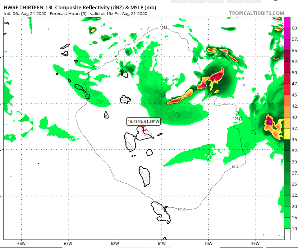
Looks like it's further NE of HWRF 06z @ 9hr
3 likes
The posts in this forum are NOT official forecasts and should not be used as such. They are just the opinion of the poster and may or may not be backed by sound meteorological data. They are NOT endorsed by any professional institution or STORM2K. For official information, please refer to products from the NHC and NWS.
Model Runs Cheat Sheet:
GFS (5:30 AM/PM, 11:30 AM/PM)
HWRF, GFDL, UKMET, NAVGEM (6:30-8:00 AM/PM, 12:30-2:00 AM/PM)
ECMWF (1:45 AM/PM)
TCVN is a weighted averaged
-
tolakram
- Admin
- Posts: 20185
- Age: 62
- Joined: Sun Aug 27, 2006 8:23 pm
- Location: Florence, KY (name is Mark)
Re: ATL: THIRTEEN - Tropical Depression - Discussion
NDG wrote:gatorcane wrote:Even if they upgrade, the system looks sheared and mid-level dry air looks to be a problem as it heads west. Also land interaction is another inhibitor. I am glad the NHC finally mentioned some of the inhibitors in the discussion which I have mentioned are there and would hinder development. The GFS and the Euro keep this weak the next 5 days. The HWRF keeps pushing back its CAT 5 prediction. I wouldn’t expect much from this wave or you may be disappointed. There is a chance that once it passes Florida it may become a hurricane but that is questionable looking at the state of the system and the inhibitors ahead.
How can you still call TS Laura a TW?
I'd like to know where the upgrade information is coming from.
0 likes
M a r k
- - - - -
Join us in chat: Storm2K Chatroom Invite. Android and IOS apps also available.
The posts in this forum are NOT official forecasts and should not be used as such. Posts are NOT endorsed by any professional institution or STORM2K.org. For official information and forecasts, please refer to NHC and NWS products.
- - - - -
Join us in chat: Storm2K Chatroom Invite. Android and IOS apps also available.
The posts in this forum are NOT official forecasts and should not be used as such. Posts are NOT endorsed by any professional institution or STORM2K.org. For official information and forecasts, please refer to NHC and NWS products.
-
eastcoastFL

- Category 5
- Posts: 3996
- Age: 44
- Joined: Thu Apr 12, 2007 12:29 pm
- Location: Palm City, FL
Re: ATL: THIRTEEN - Tropical Depression - Discussion
More TS winds north of the center. 34kts at the surface.
0 likes
Personal Forecast Disclaimer:
The posts in this forum are NOT official forecast and should not be used as such. They are just the opinion of the poster and may or may not be backed by sound meteorological data. They are NOT endorsed by any professional institution or storm2k.org. For official information, please refer to the NHC and NWS products.
The posts in this forum are NOT official forecast and should not be used as such. They are just the opinion of the poster and may or may not be backed by sound meteorological data. They are NOT endorsed by any professional institution or storm2k.org. For official information, please refer to the NHC and NWS products.
Who is online
Users browsing this forum: No registered users and 89 guests