ATL: LAURA - Post-Tropical - Discussion
Moderator: S2k Moderators
-
gatorcane

- S2K Supporter

- Posts: 23708
- Age: 48
- Joined: Sun Mar 13, 2005 3:54 pm
- Location: Boca Raton, FL
Re: ATL: LAURA - Tropical Storm - Discussion
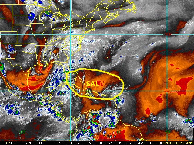
Laura is not looking good tonight that is for sure. Take a look at the SAL that is ahead and that she is surrounded by currently. Notice the deep reds indicating a very dry and stable airmass. That SAL was noticeable in South Florida today with widespread hazy skies so it is expansive. I do believe mid-level shear is allowing this SAL to infiltrate the system dissipating convection. Land interaction comes next. It is quite possible not much will be left if she makes it into the Gulf between land interaction and the SAL:
1 likes

-
wxman57

- Moderator-Pro Met

- Posts: 23173
- Age: 68
- Joined: Sat Jun 21, 2003 8:06 pm
- Location: Houston, TX (southwest)
Re: ATL: LAURA - Tropical Storm - Discussion
Nuno wrote:wxman57 wrote:Shell Mound wrote:Question one: in your view how many marginal tropical storms have been overestimated or wrongly classified since the early 2000s?
Question two: why did the ECMWF bust so dramatically in regard to Hanna? I still haven’t found a good meteorological explanation.
As for question #1, that's a hard one to answer. The NHC's job is to protect the general public, keep them safe. They tend to be overly-cautious with intensity (my opinion) with any system near land. They're quick to increase wind and very slow to indicate weakening. They do this to keep the public paying attention. That's their job. They're all excellent forecasters. I know most of them. The current NHC is much more liberal with naming than, say, the Neil Frank or Max Mayfield era. It's frustrating for me, as a private consulting meteorologist, because I want to give our clients the best information about what to expect when a storm passes. With Laura, for example, we have a client in St. John's. They have a 45 mph (NHC's intensity) tropical storm going right over them now and winds have not topped 10 mph. If it was me, I'd declare it a tropical wave and mention possible wind gusts 50-60 mph in squalls after it passes.
As for #2, I can't even remember Hanna. I'd have to go look at the reports...
What past examples stand out to you post-Max Mayfield that the NHC named that you don't think would've been named fifteen years ago?
I don't remember any specific storm. I have talked with Neil Frank a number of times about the changing classification guidelines now vs. in the 1970s/80s.
1 likes
-
wxman57
- Moderator-Pro Met
- Posts: 23173
- Age: 68
- Joined: Sat Jun 21, 2003 8:06 pm
- Location: Houston, TX (southwest)
Re: ATL: LAURA - Tropical Storm - Discussion
Looks like a very sharp wave axis tonight with max sustained wind below 30 kts. Still no surface observation from any of the islands the "center" just passed by of more than 10 kts. There may be some stronger straight-line winds in that area of squalls 150 miles to the east, but does that count as part of Laura's circulation if they're not blowing around the center? It may just reach the Gulf as a wave or a weak depression. Unfortunately, things may change in the Gulf. I did fill up my car with 2 yrs worth of gas today, and I'm fully supplied with Cheez-its, cookies, and Fanta orange drink. Ready to tough out a few days without power. I'd have to drive in to the office to work, though. The commute to my home office is much shorter.
11 likes

Re: ATL: LAURA - Tropical Storm - Discussion
00z intensity guidance for Laura is all over the place. There’s everything from a weak TS to a Category 4 hurricane, and then there’s the HMNI model, which goes off the rails and bombs this out to 165 kt.
2 likes
Irene '11 Sandy '12 Hermine '16 5/15/2018 Derecho Fay '20 Isaias '20 Elsa '21 Henri '21 Ida '21
I am only a meteorology enthusiast who knows a decent amount about tropical cyclones. Look to the professional mets, the NHC, or your local weather office for the best information.
I am only a meteorology enthusiast who knows a decent amount about tropical cyclones. Look to the professional mets, the NHC, or your local weather office for the best information.
-
Aric Dunn
- Category 5

- Posts: 21238
- Age: 43
- Joined: Sun Sep 19, 2004 9:58 pm
- Location: Ready for the Chase.
- Contact:
Re: ATL: LAURA - Tropical Storm - Discussion
the circ that developed ese of Guadalupe has rotated north as expected. if there is something trying to develop west of the islands( where recon is doing circles for some reason) it will need more convection then what currently is producing.
the convection east of the islands is slowly moving wnw towards that area.
hopefully recon at least take a look east..

the convection east of the islands is slowly moving wnw towards that area.
hopefully recon at least take a look east..
2 likes
Note: If I make a post that is brief. Please refer back to previous posts for the analysis or reasoning. I do not re-write/qoute what my initial post said each time.
If there is nothing before... then just ask
Space & Atmospheric Physicist, Embry-Riddle Aeronautical University,
I believe the sky is falling...
If there is nothing before... then just ask
Space & Atmospheric Physicist, Embry-Riddle Aeronautical University,
I believe the sky is falling...
Re: ATL: LAURA - Tropical Storm - Discussion
wxman57 wrote:Looks like a very sharp wave axis tonight with max sustained wind below 30 kts. Still no surface observation from any of the islands the "center" just passed by of more than 10 kts. There may be some stronger straight-line winds in that area of squalls 150 miles to the east, but does that count as part of Laura's circulation if they're not blowing around the center? It may just reach the Gulf as a wave or a weak depression. Unfortunately, things may change in the Gulf. I did fill up my car with 2 yrs worth of gas today, and I'm fully supplied with Cheez-its, cookies, and Fanta orange drink. Ready to tough out a few days without power. I'd have to drive in to the office to work, though. The commute to my home office is much shorter.
Agreed. Sharp wave axis. I expect NHC will keep TD using the logic you outline "likely some stronger winds in convection east of the center". They'll ignore lack of center, and I get it. Continuity...safety. But technically speaking, this is not a tropical cyclone right now.
And are the winds associated with Laura's circulation? I guess I would answer that with "what circulation?" lol. The practice has been to err on the side of including winds in squalls far from the center as storm winds, even though not really gradient-driven.
1 likes
-
toad strangler

- S2K Supporter
- Posts: 4546
- Joined: Sun Jul 28, 2013 3:09 pm
- Location: Earth
- Contact:
Re: ATL: LAURA - Tropical Storm - Discussion
gatorcane wrote:Laura is not looking good tonight that is for sure. Take a look at the SAL that is ahead and that she is surrounded by currently. Notice the deep reds indicating a very dry and stable airmass. That SAL was noticeable in South Florida today with widespread hazy skies so it is expansive. I do believe mid-level shear is allowing this SAL to infiltrate the system dissipating convection. Land interaction comes next. It is quite possible not much will be left if she makes it into the Gulf between land interaction and the SAL:
https://i.postimg.cc/ZndyB8Hr/tropical-ge-14km-wv.gif
SAL is not widespread or thick.


10 likes
My Weather Station
https://www.wunderground.com/dashboard/pws/KFLPORTS603
https://www.wunderground.com/dashboard/pws/KFLPORTS603
-
eastcoastFL

- Category 5
- Posts: 3996
- Age: 44
- Joined: Thu Apr 12, 2007 12:29 pm
- Location: Palm City, FL
Re: ATL: LAURA - Tropical Storm - Discussion
Aric Dunn wrote:the circ that developed ese of Guadalupe has rotated north as expected. if there is something trying to develop west of the islands( where recon is doing circles for some reason) it will need more convection then what currently is producing.
the convection east of the islands is slowly moving wnw towards that area.
hopefully recon at least take a look east..
https://i.ibb.co/mScnCBj/ezgif-com-gif-maker-11.gif
The last few animations In that loop showed some decent banding
2 likes
Personal Forecast Disclaimer:
The posts in this forum are NOT official forecast and should not be used as such. They are just the opinion of the poster and may or may not be backed by sound meteorological data. They are NOT endorsed by any professional institution or storm2k.org. For official information, please refer to the NHC and NWS products.
The posts in this forum are NOT official forecast and should not be used as such. They are just the opinion of the poster and may or may not be backed by sound meteorological data. They are NOT endorsed by any professional institution or storm2k.org. For official information, please refer to the NHC and NWS products.
-
eastcoastFL
- Category 5
- Posts: 3996
- Age: 44
- Joined: Thu Apr 12, 2007 12:29 pm
- Location: Palm City, FL
Re: ATL: LAURA - Tropical Storm - Discussion
toad strangler wrote:gatorcane wrote:Laura is not looking good tonight that is for sure. Take a look at the SAL that is ahead and that she is surrounded by currently. Notice the deep reds indicating a very dry and stable airmass. That SAL was noticeable in South Florida today with widespread hazy skies so it is expansive. I do believe mid-level shear is allowing this SAL to infiltrate the system dissipating convection. Land interaction comes next. It is quite possible not much will be left if she makes it into the Gulf between land interaction and the SAL:
https://i.postimg.cc/ZndyB8Hr/tropical-ge-14km-wv.gif
SAL is not widespread or thick.
https://i.ibb.co/qktJvPp/SAL.png
Doesn’t seem like very much SAL at all really. I do see a few reds but they’re very very small. Any effect it would have would be short lived wouldn’t it?
0 likes
Personal Forecast Disclaimer:
The posts in this forum are NOT official forecast and should not be used as such. They are just the opinion of the poster and may or may not be backed by sound meteorological data. They are NOT endorsed by any professional institution or storm2k.org. For official information, please refer to the NHC and NWS products.
The posts in this forum are NOT official forecast and should not be used as such. They are just the opinion of the poster and may or may not be backed by sound meteorological data. They are NOT endorsed by any professional institution or storm2k.org. For official information, please refer to the NHC and NWS products.
-
alienstorm

- Category 1

- Posts: 496
- Joined: Tue Jul 31, 2007 1:29 pm
- Location: Miami Fla western suburb
Re: ATL: LAURA - Tropical Storm - Discussion
Recon is done for the evening heading to base.
0 likes
Personal Forecast Disclaimer:The posts in this forum are NOT official forecast and should not be used as such. They are just the opinion of the poster and may or may not be backed by sound meteorological data. They are NOT endorsed by any professional institution or storm2k.org. For official information, please refer to the NHC and NWS products.
-
AxaltaRacing24
- Category 5
- Posts: 1774
- Age: 25
- Joined: Wed Jul 27, 2016 11:14 am
- Location: Jupiter, FL
Re: ATL: LAURA - Tropical Storm - Discussion
Hammy wrote:robbielyn wrote:ConvergenceZone wrote:I still say that Laura and TD 14 aren’t acting as if we a moving into the end of August at all. They are both behaving as if it’s June or July. I did not expect this
I don’t think they are behaving like june or july as much as behaving like there’s dry air at the mid levels and a tutt. If those two things were gone it would be a different scenario.
But then that gets to the question of where that historically favorable conditions are that people were talking about. And Laura looked like it was starting to spin up earlier only to fall apart again in the evening--hard to see how it really organizes if this is the daily trend.
you're about to see some of those "historically favorable conditions" if it gets into the gulf as a storm.
7 likes

Re: ATL: LAURA - Tropical Storm - Discussion
AxaltaRacing24 wrote:Hammy wrote:robbielyn wrote:
I don’t think they are behaving like june or july as much as behaving like there’s dry air at the mid levels and a tutt. If those two things were gone it would be a different scenario.
But then that gets to the question of where that historically favorable conditions are that people were talking about. And Laura looked like it was starting to spin up earlier only to fall apart again in the evening--hard to see how it really organizes if this is the daily trend.
you're about to see some of those "historically favorable conditions" if it gets into the gulf as a storm.
We were talking about how these storms hv been currently behaving. We aren’t saying a strong storm won’t develop. Just that by now these storms shouldn’t be having such a tough time.
0 likes
Robbielyn McCrary
I know just about enough to sound like I know what I'm talking about sometimes. But for your safety please follow the nhc for truly professional forecasting.
I know just about enough to sound like I know what I'm talking about sometimes. But for your safety please follow the nhc for truly professional forecasting.
-
MarioProtVI
- Category 5
- Posts: 1034
- Age: 24
- Joined: Sun Sep 29, 2019 7:33 pm
- Location: New Jersey
Re: ATL: LAURA - Tropical Storm - Discussion
There’s no island where the plane is at now (and has been for like 20 minutes)??? Little concerned
0 likes
-
CrazyC83
- Professional-Met

- Posts: 34315
- Joined: Tue Mar 07, 2006 11:57 pm
- Location: Deep South, for the first time!
Re: ATL: LAURA - Tropical Storm - Discussion
I'm starting to get Erika vibes...with the difference being a bomb factory awaits downstream, IF it can get there.
3 likes
-
gatorcane
- S2K Supporter
- Posts: 23708
- Age: 48
- Joined: Sun Mar 13, 2005 3:54 pm
- Location: Boca Raton, FL
Re: ATL: LAURA - Tropical Storm - Discussion
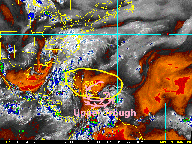
gatorcane wrote:Laura is not looking good tonight that is for sure. Take a look at the SAL that is ahead and that she is surrounded by currently. Notice the deep reds indicating a very dry and stable airmass. That SAL was noticeable in South Florida today with widespread hazy skies so it is expansive. I do believe mid-level shear is allowing this SAL to infiltrate the system dissipating convection. Land interaction comes next. It is quite possible not much will be left if she makes it into the Gulf between land interaction and the SAL:
https://i.postimg.cc/ZndyB8Hr/tropical-ge-14km-wv.gif
Updated image with the upper trough to the west of Laura the NHC mentioned in the discussion. That is also giving her problems with SW winds penetrating the dry air into any "center" that exists though she may not even have one at this point, likely a wave.
Loop image to see this all in motion:
http://rammb.cira.colostate.edu/ramsdis ... display=24
Last edited by gatorcane on Fri Aug 21, 2020 8:41 pm, edited 1 time in total.
0 likes

Re: ATL: LAURA - Tropical Storm - Discussion
MarioProtVI wrote:There’s no island where the plane is at now (and has been for like 20 minutes)??? Little concerned
Wonder if the GPS failed.
0 likes
The above post is not official and should not be used as such. It is the opinion of the poster and may or may not be backed by sound meteorological data. It is not endorsed by any professional institution or storm2k.org. For official information, please refer to the NHC and NWS products.
-
AutoPenalti
- Category 5
- Posts: 4091
- Age: 29
- Joined: Mon Aug 17, 2015 4:16 pm
- Location: Ft. Lauderdale, Florida
Re: ATL: LAURA - Tropical Storm - Discussion
CrazyC83 wrote:I'm starting to get Erika vibes...with the difference being a bomb factory awaits downstream, IF it can get there.
Which Erika?
2 likes
The posts in this forum are NOT official forecasts and should not be used as such. They are just the opinion of the poster and may or may not be backed by sound meteorological data. They are NOT endorsed by any professional institution or STORM2K. For official information, please refer to products from the NHC and NWS.
Model Runs Cheat Sheet:
GFS (5:30 AM/PM, 11:30 AM/PM)
HWRF, GFDL, UKMET, NAVGEM (6:30-8:00 AM/PM, 12:30-2:00 AM/PM)
ECMWF (1:45 AM/PM)
TCVN is a weighted averaged

Re: ATL: LAURA - Tropical Storm - Discussion
Just had a squall come through on St Maarten. Some thunder and lightning. Not much wind.
3 likes
Too many hurricanes to remember
Who is online
Users browsing this forum: No registered users and 10 guests