ATL: LAURA - Post-Tropical - Discussion

Moderator: S2k Moderators

Message
Author
User avatar
1900hurricane
Category 5
Category 5
Posts: 6059
Age: 34
Joined: Fri Feb 06, 2015 12:04 pm
Location: Houston, TX
Contact:

Re: ATL: LAURA - Tropical Storm - Discussion

#2581 Postby 1900hurricane » Sun Aug 23, 2020 8:36 am

TheDreamTraveler wrote:Laura's a 2nd example this year that Hispaniola doesn't always end up being detrimental to storms. The stronger storms with tight cores take a harsher beating and sometimes just outright die after interacting with the mountains while very weak poorly put together storms don't see much of a negative effect

Yeah, Hispaniola isn't the end-all be-all destroyer of every single TC that comes near it. StruThiO made a good post about it earlier, although I can't seem to find it anymore. Must be buried several pages back.
5 likes   
Contract Meteorologist. TAMU & MSST. Fiercely authentic, one of a kind. We are all given free will, so choose a life meant to be lived. We are the Masters of our own Stories.
Opinions expressed are mine alone.

Follow me on Twitter at @1900hurricane : Read blogs at https://1900hurricane.wordpress.com/

User avatar
toad strangler
S2K Supporter
S2K Supporter
Posts: 4546
Joined: Sun Jul 28, 2013 3:09 pm
Location: Earth
Contact:

Re: ATL: LAURA - Tropical Storm - Discussion

#2582 Postby toad strangler » Sun Aug 23, 2020 8:37 am

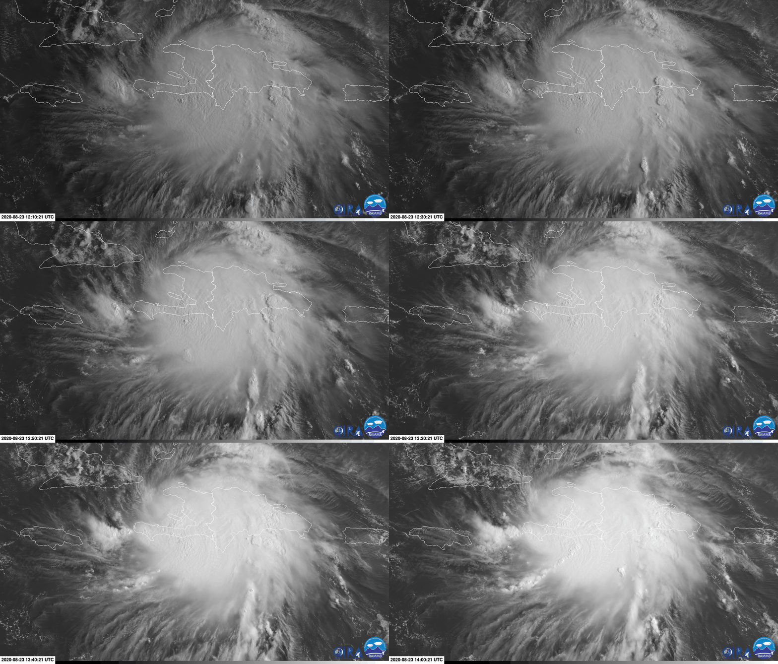
Man, Laura looks extremely put together this morning for a storm that's been sucking at high mountains all night :eek:

Sidenote - TX landfalls historically happen more in August than in any other month.
3 likes   

canes04
Category 1
Category 1
Posts: 302
Joined: Sat May 22, 2004 5:41 pm
Location: Miami, FL

Re: ATL: LAURA - Tropical Storm - Discussion

#2583 Postby canes04 » Sun Aug 23, 2020 8:38 am

Has she slowed down over the last 6 hours or so?
Will a southern route give her time to feel the weakness and turn North?
0 likes   

Aric Dunn
Category 5
Category 5
Posts: 21238
Age: 42
Joined: Sun Sep 19, 2004 9:58 pm
Location: Ready for the Chase.
Contact:

Re: ATL: LAURA - Tropical Storm - Discussion

#2584 Postby Aric Dunn » Sun Aug 23, 2020 8:44 am

From surface obs and satellite and other stuff..

the center is over water west of Port au Prince and looks due west.

already appears wsw of the NHC track and increasing..
3 likes   
Note: If I make a post that is brief. Please refer back to previous posts for the analysis or reasoning. I do not re-write/qoute what my initial post said each time.
If there is nothing before... then just ask :)

Space & Atmospheric Physicist, Embry-Riddle Aeronautical University,
I believe the sky is falling...

Nederlander
S2K Supporter
S2K Supporter
Posts: 1251
Joined: Sat Jul 19, 2008 4:28 pm
Location: Conroe, TX

Re: ATL: LAURA - Tropical Storm - Discussion

#2585 Postby Nederlander » Sun Aug 23, 2020 8:58 am

canes04 wrote:Has she slowed down over the last 6 hours or so?
Will a southern route give her time to feel the weakness and turn North?

Southern route would give more time for ridging to build in, but I would caution against watching every little wobble or move at this point (even though I know we all will lol). Let’s see where it’s at after Cuba.
3 likes   

St0rmTh0r
Category 1
Category 1
Posts: 369
Joined: Tue Jul 14, 2020 8:04 pm

Re: ATL: LAURA - Tropical Storm - Discussion

#2586 Postby St0rmTh0r » Sun Aug 23, 2020 8:59 am

3090 wrote:
txag2005 wrote:
3090 wrote:
“NHC forecast track will be moving back and forth within a window between Vermillion bay and the Mississippi gulf coast. She will probably end up making landfall somewhere right in the middle of that window.


If you read the forecast, it sounds like they are becoming more confident about a more Western run but are just waiting for a bit more data to confirm.


No where does it mention, or sound like...”waiting for a bit more data to confirm”.


000
WTNT43 KNHC 230859
TCDAT3

Tropical Storm Laura Discussion Number 14
NWS National Hurricane Center Miami FL AL132020
500 AM EDT Sun Aug 23 2020

Laura has maintained an impressive convective pattern despite the
center being located over extreme south-central Dominican Republic.
Numerous cloud tops of -85C to -90C have been noted over the
Barahona peninsula, an indication that extremely heavy rainfall has
been occurring there. The center of Laura passed over or very near
Santo Domingo around 0430Z based on a noticeable wind shift that
was measured at the international airport. Laura's outflow pattern
has also continue to improve in all quadrants. The initial intensity
of 40 kt is based on earlier scatterometer and aircraft data, along
with surface observations along the north coast of the Dominican
Republic.

Laura has continued to move west-northwestward and the initial
motion estimate is now 285/16 kt. There has been a significant
westward shift in the latest NHC model guidance, which appears to be
due to most of the global models taking the center of Laura farther
south over central or southern Hispaniola rather than emerging it
off the north coast of Haiti like the GFS is and has been
forecasting. Given that the most intense convection has persisted
along the southern coast of Hispaniola, that is where the most
likely area that a low-level and/or mid-level circulation is most
probable to develop or persist. As a result, the new NHC track
forecast favors a more southerly and westerly track solution
similar to the preponderance of the track guidance. However, the
new forecast track has not been shifted as far to the left as the
consensus models in the event that the models shift back to the
north. However, the latter scenario is appearing less likely based
observed satellite trends since the previous advisory.

Little if any significant change in strength is expected due to
Laura moving pretty much down the spine of Hispaniola and Cuba
during the the next 36 hours, with the strongest wind likely
remaining over water in the northeast quadrant where the pressure
gradient will be the tightest between the cyclone and the Bermuda
High. [b][u]By 48 hours and continuing until landfall, Laura is forecast
to remain in a low shear and very favorable upper-level outflow
environment while passing of extremely warm SSTs near 31C. This
should allow for significant strengthening to occur once the cyclone
regains a decent inner core after exiting Cuba.
[/u]
[/b]The new NHC
intensity forecast is a blend of the intensity forecasts by the GFS
and ECMWF global models and the corrected consensus models HCCA and
FSSE.

Key Messages:

1. Tropical storm conditions are expected across portions of the
Dominican Republic and Haiti, the Turks and Caicos, the
southeastern Bahamas, and Cuba through Monday. Heavy rainfall is
likely across these areas and could cause mudslides and flash and
urban flooding.

2. Tropical storm conditions are possible the central Bahamas and
Andros Island tonight and Monday, and in the Florida Keys on
Monday.

3. The details of the long-range track and intensity forecasts
remain uncertain since Laura is forecast to move near or over
portions of the Greater Antilles through Monday. However, Laura is
forecast to strengthen over the Gulf of Mexico and could bring storm
surge, rainfall, and wind impacts to portions of the U.S. Gulf Coast
by the middle of next week. This could result in a prolonged period
of hazardous weather for areas that are likely to be affected by
Tropical Storm Marco earlier in the week. Interests there should
monitor the progress of Laura and Marco and updates to the forecast
during the next few days.

Low shear very favorable upper environment with very warm waters 31c. The way the storm already looks this will be one for the books!
0 likes   

User avatar
SoupBone
Category 5
Category 5
Posts: 3111
Joined: Tue Sep 20, 2005 5:24 pm

Re: ATL: LAURA - Tropical Storm - Discussion

#2587 Postby SoupBone » Sun Aug 23, 2020 8:59 am

Specifically for Galveston/Houston, this setup in the models will be literally threading the needle. From Beaumont to Lake Charles it would be a Rita style setup. Any further west she goes, and Galveston/Houston would have major issues.
2 likes   
Personal Forecast Disclaimer:
The posts in this forum are NOT official forecast and should not be used as such. They are just the opinion of the poster and may or may not be backed by sound meteorological data. They are NOT endorsed by any professional institution or storm2k.org. For official information, please refer to the NHC and NWS products.

TheStormExpert

Re: ATL: LAURA - Tropical Storm - Discussion

#2588 Postby TheStormExpert » Sun Aug 23, 2020 9:07 am

A developing and organizing TC over Hispaniola!? :eek: 2020 never ceases to surprise! And to think a few days ago I was starting to write this storm off due to its very crappy appearance.

All in all it looks like a major hurricane landfall is becoming more and more likely for someone along the U.S. Gulf Coast mid-week.
:double:

Image
3 likes   

User avatar
nativefloridian
Tropical Storm
Tropical Storm
Posts: 172
Joined: Tue Aug 21, 2012 2:48 pm
Location: Pembroke Pines, FL

Re: ATL: LAURA - Tropical Storm - Discussion

#2589 Postby nativefloridian » Sun Aug 23, 2020 9:13 am

Are my eyes deceiving me after viewing so many satellite loops? Because it appears to me that she hasn't moved very much since this morning. Could that be possible due to the land interaction or atmosphere effects from Marco?
0 likes   

User avatar
Kazmit
Category 5
Category 5
Posts: 2131
Age: 22
Joined: Mon Jul 25, 2016 8:49 am
Location: Bermuda

Re: ATL: LAURA - Tropical Storm - Discussion

#2590 Postby Kazmit » Sun Aug 23, 2020 9:13 am

Classic 2020. Looked like a shrimp over water and is now a beast over mountainous land.
2 likes   
Igor 2010, Sandy 2012, Fay 2014, Gonzalo 2014, Joaquin 2015, Nicole 2016, Humberto 2019

I am only a tropical weather enthusiast. My predictions are not official and may or may not be backed by sound meteorological data. For official information, please refer to the NHC and NWS products.

TheStormExpert

Re: ATL: LAURA - Tropical Storm - Discussion

#2591 Postby TheStormExpert » Sun Aug 23, 2020 9:14 am

4 likes   

User avatar
mpic
S2K Supporter
S2K Supporter
Posts: 623
Joined: Thu Oct 20, 2005 11:24 am
Location: Splendora, TX

Re: ATL: LAURA - Tropical Storm - Discussion

#2592 Postby mpic » Sun Aug 23, 2020 9:15 am

SoupBone wrote:Specifically for Galveston/Houston, this setup in the models will be literally threading the needle. From Beaumont to Lake Charles it would be a Rita style setup. Any further west she goes, and Galveston/Houston would have major issues.


Going to be a nail biter for sure. I was stuck for 24 hours during Rita and ended up in the eye at Woodville. Never again. I've moved 60 miles north from where I was then and will just stick it out.
3 likes   
Alicia, Rita, Ike, Harvey and Beryl...moved to Splendora lol

TheStormExpert

Re: ATL: LAURA - Tropical Storm - Discussion

#2593 Postby TheStormExpert » Sun Aug 23, 2020 9:15 am

Kazmit wrote:Classic 2020. Looked like a shrimp over water and is now a beast over mountainous land.

Second storm this season to do so over this mountainous island. :eek:
5 likes   

TheStormExpert

Re: ATL: LAURA - Tropical Storm - Discussion

#2594 Postby TheStormExpert » Sun Aug 23, 2020 9:20 am

The environment out ahead of Laura should be EXTREMELY favorable with a anticyclone already overhead once in the Gulf it should bomb out!

Image
0 likes   

User avatar
Kazmit
Category 5
Category 5
Posts: 2131
Age: 22
Joined: Mon Jul 25, 2016 8:49 am
Location: Bermuda

Re: ATL: LAURA - Tropical Storm - Discussion

#2595 Postby Kazmit » Sun Aug 23, 2020 9:21 am

50kts at 11am?
0 likes   
Igor 2010, Sandy 2012, Fay 2014, Gonzalo 2014, Joaquin 2015, Nicole 2016, Humberto 2019

I am only a tropical weather enthusiast. My predictions are not official and may or may not be backed by sound meteorological data. For official information, please refer to the NHC and NWS products.

sphelps8681
Category 2
Category 2
Posts: 785
Joined: Thu Aug 16, 2007 5:37 pm
Location: Somewhere over the rainbow

Re: ATL: LAURA - Tropical Storm - Discussion

#2596 Postby sphelps8681 » Sun Aug 23, 2020 9:21 am

mpic wrote:
SoupBone wrote:Specifically for Galveston/Houston, this setup in the models will be literally threading the needle. From Beaumont to Lake Charles it would be a Rita style setup. Any further west she goes, and Galveston/Houston would have major issues.


Going to be a nail biter for sure. I was stuck for 24 hours during Rita and ended up in the eye at Woodville. Never again. I've moved 60 miles north from where I was then and will just stick it out.


I am in Lumberton and road out Rita. We left after about a week of no power to go further north. Ended up having to go to Dallas because of no places before that. Came back and still no power for about a month. Riding it out again.
3 likes   

User avatar
Kazmit
Category 5
Category 5
Posts: 2131
Age: 22
Joined: Mon Jul 25, 2016 8:49 am
Location: Bermuda

Re: ATL: LAURA - Tropical Storm - Discussion

#2597 Postby Kazmit » Sun Aug 23, 2020 9:26 am

Image
3 likes   
Igor 2010, Sandy 2012, Fay 2014, Gonzalo 2014, Joaquin 2015, Nicole 2016, Humberto 2019

I am only a tropical weather enthusiast. My predictions are not official and may or may not be backed by sound meteorological data. For official information, please refer to the NHC and NWS products.

supercane4867
Category 5
Category 5
Posts: 4966
Joined: Wed Nov 14, 2012 10:43 am

Re: ATL: LAURA - Tropical Storm - Discussion

#2598 Postby supercane4867 » Sun Aug 23, 2020 9:29 am

Impressive terrain induced convection.

Image
1 likes   


User avatar
aspen
Category 5
Category 5
Posts: 8860
Joined: Sat Oct 12, 2019 7:10 pm
Location: Connecticut, USA

Re: ATL: LAURA - Tropical Storm - Discussion

#2600 Postby aspen » Sun Aug 23, 2020 9:29 am

I only see two potential roadblocks for Laura once it gets into the Gulf: time and internal structure. The first shouldn’t be much of a big deal; it has ~48 hours between exiting Cuba and making landfall, which is close to the time Harvey had. However, the second will probably be more significant, because so far Laura’s circulation has remained quite broad despite going over Hispaniola. A larger circulation will make it more difficult to tighten up and bomb out, but there’s still plenty of time for this to change.
2 likes   
Irene '11 Sandy '12 Hermine '16 5/15/2018 Derecho Fay '20 Isaias '20 Elsa '21 Henri '21 Ida '21

I am only a meteorology enthusiast who knows a decent amount about tropical cyclones. Look to the professional mets, the NHC, or your local weather office for the best information.


Return to “2020”

Who is online

Users browsing this forum: No registered users and 20 guests