ATL: LAURA - Post-Tropical - Discussion
Moderator: S2k Moderators

Re: ATL: LAURA - Tropical Storm - Discussion
It's stair stepping. Took a jog E of its previous motion, now it seems to be correcting over land and heading dead west. the mean storm motion remains mostly unchanged as I see it
4 likes
Very useful information on the Dvorak Technique --
https://severe.worldweather.wmo.int/TCF ... kBeven.pdf
https://severe.worldweather.wmo.int/TCF ... kBeven.pdf
-
EquusStorm
- Category 5

- Posts: 1649
- Age: 35
- Joined: Thu Nov 07, 2013 1:04 pm
- Location: Jasper, AL
- Contact:
Re: ATL: LAURA - Tropical Storm - Discussion
I think we're about to see what Fay could have done had she not insisted on staying on land for 90% of the track; seems kinda like a cousin.
4 likes
Colors of lost purpose on the canvas of irrelevance
Not a meteorologist, in fact more of an idiot than anything. You should probably check with the NHC or a local NWS office for official information.
Not a meteorologist, in fact more of an idiot than anything. You should probably check with the NHC or a local NWS office for official information.
-
cfisher
Re: ATL: LAURA - Tropical Storm - Discussion
Aric Dunn wrote:Seeing a jump to the north coast is a distinct possibility as that convective burst moves over water.
I doubt there's enough low level vorticity to support it
0 likes
-
Kingarabian

- S2K Supporter

- Posts: 16353
- Joined: Sat Aug 08, 2009 3:06 am
- Location: Honolulu, Hawaii
Re: ATL: LAURA - Tropical Storm - Discussion

Always good to see how Dvorak is doing with recon in the system. So far it's doing pretty good.

UW - CIMSS
ADVANCED DVORAK TECHNIQUE
ADT-Version 9.0
Tropical Cyclone Intensity Algorithm
----- Current Analysis -----
Date : 24 AUG 2020 Time : 235021 UTC
Lat : 21:59:59 N Lon : 82:56:22 W
CI# /Pressure/ Vmax
3.4 / 992.5mb/ 53.0kt
Final T# Adj T# Raw T#
3.3 3.2 3.2
Center Temp : -37.5C Cloud Region Temp : -59.2C
Scene Type : CURVED BAND with 0.83 ARC in LT GRAY
1 likes
RIP Kobe Bryant
-
eastcoastFL

- Category 5
- Posts: 3996
- Age: 44
- Joined: Thu Apr 12, 2007 12:29 pm
- Location: Palm City, FL
Re: ATL: LAURA - Tropical Storm - Discussion
Steve wrote:eastcoastFL wrote:So 18z HWRF comes in on the Texas LA border 929mb. Is that area heavily populated?
400k in the Triangle, 225k in Lake Charles. (Beaumont, Port Arthur, Orange, Lake Charles/Sulphur are the main cities).
Would you say its a fairly low lying area? Do they have construction code in LA like here in S.Fl where they build homes with cement block mostly?
0 likes
Personal Forecast Disclaimer:
The posts in this forum are NOT official forecast and should not be used as such. They are just the opinion of the poster and may or may not be backed by sound meteorological data. They are NOT endorsed by any professional institution or storm2k.org. For official information, please refer to the NHC and NWS products.
The posts in this forum are NOT official forecast and should not be used as such. They are just the opinion of the poster and may or may not be backed by sound meteorological data. They are NOT endorsed by any professional institution or storm2k.org. For official information, please refer to the NHC and NWS products.
-
cycloneye

- Admin

- Posts: 149357
- Age: 69
- Joined: Thu Oct 10, 2002 10:54 am
- Location: San Juan, Puerto Rico
Re: ATL: LAURA - Tropical Storm - Discussion
3 likes
Visit the Caribbean-Central America Weather Thread where you can find at first post web cams,radars
and observations from Caribbean basin members Click Here
and observations from Caribbean basin members Click Here
-
eastcoastFL
- Category 5
- Posts: 3996
- Age: 44
- Joined: Thu Apr 12, 2007 12:29 pm
- Location: Palm City, FL
Re: ATL: LAURA - Tropical Storm - Discussion
Snowman67 wrote:The 8PM EST Advisory still shows this a TC at 2PM EST tomorrow. I thought that they would have had it as a hurricane by then. I know it has to go over another strip of land in Cuba, but won't be surprised if she's a hurricane prior to then.
I'm not sure if they update that on intermediate advisories but I could be wrong. At 11pm it might be different.
1 likes
Personal Forecast Disclaimer:
The posts in this forum are NOT official forecast and should not be used as such. They are just the opinion of the poster and may or may not be backed by sound meteorological data. They are NOT endorsed by any professional institution or storm2k.org. For official information, please refer to the NHC and NWS products.
The posts in this forum are NOT official forecast and should not be used as such. They are just the opinion of the poster and may or may not be backed by sound meteorological data. They are NOT endorsed by any professional institution or storm2k.org. For official information, please refer to the NHC and NWS products.
-
Nederlander
- S2K Supporter
- Posts: 1259
- Joined: Sat Jul 19, 2008 4:28 pm
- Location: Conroe, TX
Re: ATL: LAURA - Tropical Storm - Discussion
cycloneye wrote:https://twitter.com/pppapin/status/1298055296401780736
I don’t think it’ll take until midnight tbh.
0 likes
Re: ATL: LAURA - Tropical Storm - Discussion
Wouldn't surprise me if Laura emerges over water faster than the models are predicting. the llc may edge southward to where the most convection is thereafter. things get fun from there.
Last edited by Highteeld on Mon Aug 24, 2020 7:35 pm, edited 1 time in total.
1 likes
Very useful information on the Dvorak Technique --
https://severe.worldweather.wmo.int/TCF ... kBeven.pdf
https://severe.worldweather.wmo.int/TCF ... kBeven.pdf
-
tolakram
- Admin
- Posts: 20183
- Age: 62
- Joined: Sun Aug 27, 2006 8:23 pm
- Location: Florence, KY (name is Mark)
Re: ATL: LAURA - Tropical Storm - Discussion
7 likes
M a r k
- - - - -
Join us in chat: Storm2K Chatroom Invite. Android and IOS apps also available.
The posts in this forum are NOT official forecasts and should not be used as such. Posts are NOT endorsed by any professional institution or STORM2K.org. For official information and forecasts, please refer to NHC and NWS products.
Re: ATL: LAURA - Tropical Storm - Discussion
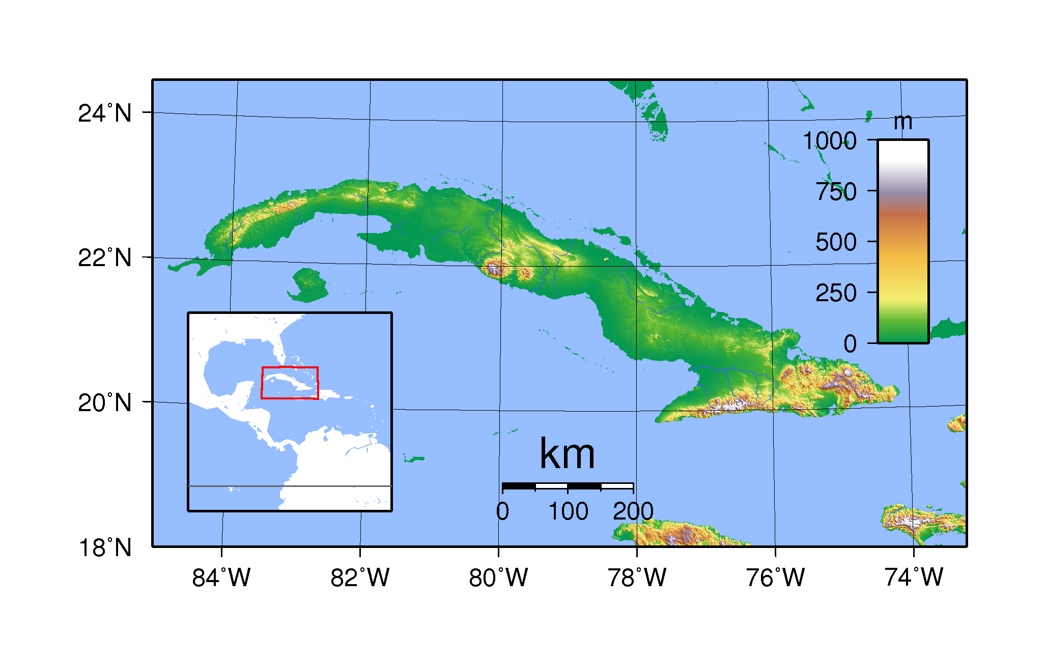
any hi-res topo maps of cuba?
0 likes
Very useful information on the Dvorak Technique --
https://severe.worldweather.wmo.int/TCF ... kBeven.pdf
https://severe.worldweather.wmo.int/TCF ... kBeven.pdf
Re: ATL: LAURA - Tropical Storm - Discussion
eastcoastFL wrote:Steve wrote:eastcoastFL wrote:So 18z HWRF comes in on the Texas LA border 929mb. Is that area heavily populated?
400k in the Triangle, 225k in Lake Charles. (Beaumont, Port Arthur, Orange, Lake Charles/Sulphur are the main cities).
Would you say its a fairly low lying area? Do they have construction code in LA like here in S.Fl where they build homes with cement block mostly?
Most of the homes south of Lake Charles that survived Ike and Rita, are not made of cement, I think there isn't that many made of cement, the building codes were not updated like in Florida after Andrew. So the only code that was updated was the elevation of the homes, all homes south of Intracoastal Waterway are either on stilts or built up mounds of earth. A lot of insurance companies will not even insure homes south of Hwy 90. And all the land south of I-10 is low lying, I'm 30 miles from the coast line as the crow flies and only 22 or so feet above sea level. A lot of the area south of the Intracoastal is marsh land. There are natural water breaks (earth mounds) through out the areas between the coast and I-10
Last edited by Blinhart on Mon Aug 24, 2020 7:39 pm, edited 1 time in total.
3 likes
Personal Forecast Disclaimer:
The posts in this forum are NOT official forecast and should not be used as such. They are just the opinion of the poster and may or may not be backed by sound meteorological data. They are NOT endorsed by any professional institution or storm2k.org. For official information, please refer to the NHC and NWS products.
The posts in this forum are NOT official forecast and should not be used as such. They are just the opinion of the poster and may or may not be backed by sound meteorological data. They are NOT endorsed by any professional institution or storm2k.org. For official information, please refer to the NHC and NWS products.
-
PavelGaborik10
- Category 1

- Posts: 472
- Joined: Tue Sep 04, 2018 3:23 pm
Re: ATL: LAURA - Tropical Storm - Discussion
Lord she already appears to be over halfway through that strip of Cuba.
Things are about to get very, very interesting.
Things are about to get very, very interesting.
1 likes
-
BYG Jacob
Re: ATL: LAURA - Tropical Storm - Discussion
tolakram wrote:https://imgur.com/F1hDiNA
Just developing an eyewall over Cuba, no biggie
4 likes

Re: ATL: LAURA - Tropical Storm - Discussion
Three cheers for science-driven diplomacy! I always thought recon avoided land fixes for safety reasons; didn't realize it was geopolitical.
https://twitter.com/AndyHazelton/status/1298052227475611648
https://twitter.com/AndyHazelton/status/1298052227475611648
4 likes
I'm a busy grad student, not a professional forecaster. Please refer to the NHC and NWS for official forecasts.
-
cfisher
Re: ATL: LAURA - Tropical Storm - Discussion
The burst of convection to the northeast should help jumpstart northward polar outflow
1 likes
-
tropicwatch

- Category 5
- Posts: 3426
- Age: 62
- Joined: Sat Jun 02, 2007 10:01 am
- Location: Panama City Florida
- Contact:
Re: ATL: LAURA - Tropical Storm - Discussion
Didn't see if it was already mentioned but this is the first time I recall HH being able to over fly Cuba and they even seem to be taking readings. Pretty wild 
6 likes
Tropicwatch
Agnes 72', Eloise 75, Elena 85', Kate 85', Charley 86', Florence 88', Beryl 94', Dean 95', Erin 95', Opal 95', Earl 98', Georges 98', Ivan 2004', Arlene 2005', Dennis 2005', Ida 2009' Debby 2012' Irma 2017' Michael 2018'
Agnes 72', Eloise 75, Elena 85', Kate 85', Charley 86', Florence 88', Beryl 94', Dean 95', Erin 95', Opal 95', Earl 98', Georges 98', Ivan 2004', Arlene 2005', Dennis 2005', Ida 2009' Debby 2012' Irma 2017' Michael 2018'

Re: ATL: LAURA - Tropical Storm - Discussion
Highteeld wrote:any hi-res topo maps of cuba?
https://www.mapsland.com/maps/north-america/cuba/large-topographical-map-of-cuba.jpg
1 likes
Igor 2010, Sandy 2012, Fay 2014, Gonzalo 2014, Joaquin 2015, Nicole 2016, Humberto 2019, Imelda 2025
I am only a tropical weather enthusiast. My predictions are not official and may or may not be backed by sound meteorological data. For official information, please refer to the NHC and NWS products.
I am only a tropical weather enthusiast. My predictions are not official and may or may not be backed by sound meteorological data. For official information, please refer to the NHC and NWS products.
Re: ATL: LAURA - Tropical Storm - Discussion
tolakram wrote:https://imgur.com/F1hDiNA
Looks like she is about to splash-down in the next hour or so.
0 likes
Personal Forecast Disclaimer:
The posts in this forum are NOT official forecast and should not be used as such. They are just the opinion of the poster and may or may not be backed by sound meteorological data. They are NOT endorsed by any professional institution or storm2k.org. For official information, please refer to the NHC and NWS products.
The posts in this forum are NOT official forecast and should not be used as such. They are just the opinion of the poster and may or may not be backed by sound meteorological data. They are NOT endorsed by any professional institution or storm2k.org. For official information, please refer to the NHC and NWS products.
Re: ATL: LAURA - Tropical Storm - Discussion
BYG Jacob wrote:tolakram wrote:https://imgur.com/F1hDiNA
Just developing an eyewall over Cuba, no biggie
Taking a stab in the dark here, but it would seem laura's eye made landfall just west of the highest terrain over western Cuba. This to me seems like it would add a frictional component that could tighten the circulation from the east side of the eyewall. it looks tighter on radar, which could mean less time needed to spin up over the gulf. gahhh, i don't know
Last edited by Highteeld on Mon Aug 24, 2020 7:42 pm, edited 1 time in total.
2 likes
Very useful information on the Dvorak Technique --
https://severe.worldweather.wmo.int/TCF ... kBeven.pdf
https://severe.worldweather.wmo.int/TCF ... kBeven.pdf
Who is online
Users browsing this forum: No registered users and 4 guests