ATL: LAURA - Post-Tropical - Discussion
Moderator: S2k Moderators
-
supercane4867
- Category 5

- Posts: 4966
- Joined: Wed Nov 14, 2012 10:43 am
-
cfisher
Re: ATL: LAURA - Hurricane - Discussion
HurricaneEdouard wrote:cfisher wrote:Looking like an annular hurricane on IR. There's nothing stopping Laura from bottoming out at MPI.
It isn't looking annular. Annular is one of the most widely misapplied terms on this board, and weather boards generally (often used to mean "symmetrical" generally); an annular hurricane features a donut of convection around a large eye, with no banding features and little to no convection outside of the central dense overcast. It also isn't the structure most associated with extreme intensity and you'd be unlikely to find an annular hurricane over the Gulf; rather, annular hurricanes take on their unique structure due to modest, rather than extremely warm, SSTs (typically between 25.4 and 28.5 C).
An annular hurricane looks like this:
(Super Typhoon Nestor)
https://upload.wikimedia.org/wikipedia/commons/9/9e/Typhoon_Nestor_%281997%29.gif
(Hurricane Isabel)
https://pbs.twimg.com/media/EfPDtOaWsAgf6VM.png
(Hurricane Daniel)
https://upload.wikimedia.org/wikipedia/commons/e/ec/Hurricane_Daniel_peak.jpg
It's a very specific structure.
Those are bottomed out annular cyclones, Laura isn't there yet. Not a good comparison at all, but if you look at the dual wide inflow bands of high convection, it's certainly on its way.
0 likes
Re: ATL: LAURA - Hurricane - Discussion
NOAA aircraft is likely passing through an eye/eyewall mesovortex.
0 likes
Personal Forecast Disclaimer:
The posts in this forum are NOT official forecast and should not be used as such. They are just the opinion of the poster and may or may not be backed by sound meteorological data. They are NOT endorsed by any professional institution or storm2k.org. For official information, please refer to RSMC and NWS products.
The posts in this forum are NOT official forecast and should not be used as such. They are just the opinion of the poster and may or may not be backed by sound meteorological data. They are NOT endorsed by any professional institution or storm2k.org. For official information, please refer to RSMC and NWS products.
-
supercane4867
- Category 5
- Posts: 4966
- Joined: Wed Nov 14, 2012 10:43 am


Re: ATL: LAURA - Hurricane - Discussion
supercane4867 wrote:EYE is warming at a decent pace on IR. ADT raw# 6.9
https://i.imgur.com/qkopxFY.gif
Wow this looks like Michael! Michael never went through an ERC so it will be interesting to see what Laura does.
0 likes

Re: ATL: LAURA - Hurricane - Discussion
The NOAA flight is circulating around in the eye, just reported a pressure of 952.8!!
NOAA2 2213A LAURA HDOB 11 20200826
104430 2616N 09102W 6440 03545 9681 +125 //// 121019 021 /// /// 05
104500 2615N 09105W 6442 03541 9681 +126 //// 114016 016 /// /// 05
104530 2616N 09107W 6443 03540 9684 +123 //// 116019 021 /// /// 05
104600 2619N 09107W 6445 03542 9680 +129 //// 122023 023 /// /// 05
104630 2620N 09106W 6440 03547 9668 +138 //// 117026 027 /// /// 05
104700 2620N 09104W 6444 03543 9672 +135 //// 119025 027 /// /// 05
104730 2619N 09102W 6445 03541 9672 +133 //// 121022 023 /// /// 05
104800 2617N 09103W 6440 03544 9686 +122 //// 121017 020 /// /// 05
104830 2616N 09105W 6443 03540 9685 +122 //// 112016 017 /// /// 05
104900 2617N 09108W 6448 03539 9671 +123 -278 114016 018 /// /// 03
104930 2619N 09108W 6442 03542 9654 +130 -212 116022 023 /// /// 03
105000 2621N 09107W 6440 03546 9630 +139 -024 110026 026 /// /// 03
105030 2621N 09105W 6444 03542 9591 +137 //// 117026 027 /// /// 05
105100 2619N 09104W 6441 03543 9560 +131 //// 129024 025 /// /// 05
105130 2617N 09104W 6450 03535 9544 +124 //// 138017 019 /// /// 05
105200 2616N 09106W 6442 03540 9528 +123 //// 130012 012 /// /// 05
105230 2617N 09108W 6440 03544 9633 +121 //// 116014 018 /// /// 05
105300 2619N 09109W 6449 03538 9651 +132 +084 114021 023 /// /// 03
105330 2621N 09108W 6442 03542 9641 +140 +060 109024 024 /// /// 03
105400 2621N 09106W 6444 03540 9645 +135 +079 115025 025 /// /// 03
0 likes
-
supercane4867
- Category 5
- Posts: 4966
- Joined: Wed Nov 14, 2012 10:43 am
Re: ATL: LAURA - Hurricane - Discussion
Jr0d wrote:The NOAA flight is circulating around in the eye, just reported a pressure of 952.8!!
NOAA2 2213A LAURA HDOB 11 20200826
104430 2616N 09102W 6440 03545 9681 +125 //// 121019 021 /// /// 05
104500 2615N 09105W 6442 03541 9681 +126 //// 114016 016 /// /// 05
104530 2616N 09107W 6443 03540 9684 +123 //// 116019 021 /// /// 05
104600 2619N 09107W 6445 03542 9680 +129 //// 122023 023 /// /// 05
104630 2620N 09106W 6440 03547 9668 +138 //// 117026 027 /// /// 05
104700 2620N 09104W 6444 03543 9672 +135 //// 119025 027 /// /// 05
104730 2619N 09102W 6445 03541 9672 +133 //// 121022 023 /// /// 05
104800 2617N 09103W 6440 03544 9686 +122 //// 121017 020 /// /// 05
104830 2616N 09105W 6443 03540 9685 +122 //// 112016 017 /// /// 05
104900 2617N 09108W 6448 03539 9671 +123 -278 114016 018 /// /// 03
104930 2619N 09108W 6442 03542 9654 +130 -212 116022 023 /// /// 03
105000 2621N 09107W 6440 03546 9630 +139 -024 110026 026 /// /// 03
105030 2621N 09105W 6444 03542 9591 +137 //// 117026 027 /// /// 05
105100 2619N 09104W 6441 03543 9560 +131 //// 129024 025 /// /// 05
105130 2617N 09104W 6450 03535 9544 +124 //// 138017 019 /// /// 05
105200 2616N 09106W 6442 03540 9528 +123 //// 130012 012 /// /// 05
105230 2617N 09108W 6440 03544 9633 +121 //// 116014 018 /// /// 05
105300 2619N 09109W 6449 03538 9651 +132 +084 114021 023 /// /// 03
105330 2621N 09108W 6442 03542 9641 +140 +060 109024 024 /// /// 03
105400 2621N 09106W 6444 03540 9645 +135 +079 115025 025 /// /// 03
This is likely off.
0 likes
-
USTropics
- Professional-Met

- Posts: 2738
- Joined: Sun Aug 12, 2007 3:45 am
- Location: Florida State University
Re: ATL: LAURA - Hurricane - Discussion
supercane4867 wrote:NOAA plane doing loops and loops in the eye...
That's typical in an intense hurricane. They will fly around in the center and use radar onboard to find a "clean" way out (there's a lot more complications when flying into an intense and strengthening system). They also will do this when they're staging a lot of dropsondes.
3 likes
-
cfisher
Re: ATL: LAURA - Hurricane - Discussion
Jr0d wrote:The NOAA flight is circulating around in the eye, just reported a pressure of 952.8!!
NOAA2 2213A LAURA HDOB 11 20200826
104430 2616N 09102W 6440 03545 9681 +125 //// 121019 021 /// /// 05
104500 2615N 09105W 6442 03541 9681 +126 //// 114016 016 /// /// 05
104530 2616N 09107W 6443 03540 9684 +123 //// 116019 021 /// /// 05
104600 2619N 09107W 6445 03542 9680 +129 //// 122023 023 /// /// 05
104630 2620N 09106W 6440 03547 9668 +138 //// 117026 027 /// /// 05
104700 2620N 09104W 6444 03543 9672 +135 //// 119025 027 /// /// 05
104730 2619N 09102W 6445 03541 9672 +133 //// 121022 023 /// /// 05
104800 2617N 09103W 6440 03544 9686 +122 //// 121017 020 /// /// 05
104830 2616N 09105W 6443 03540 9685 +122 //// 112016 017 /// /// 05
104900 2617N 09108W 6448 03539 9671 +123 -278 114016 018 /// /// 03
104930 2619N 09108W 6442 03542 9654 +130 -212 116022 023 /// /// 03
105000 2621N 09107W 6440 03546 9630 +139 -024 110026 026 /// /// 03
105030 2621N 09105W 6444 03542 9591 +137 //// 117026 027 /// /// 05
105100 2619N 09104W 6441 03543 9560 +131 //// 129024 025 /// /// 05
105130 2617N 09104W 6450 03535 9544 +124 //// 138017 019 /// /// 05
105200 2616N 09106W 6442 03540 9528 +123 //// 130012 012 /// /// 05
105230 2617N 09108W 6440 03544 9633 +121 //// 116014 018 /// /// 05
105300 2619N 09109W 6449 03538 9651 +132 +084 114021 023 /// /// 03
105330 2621N 09108W 6442 03542 9641 +140 +060 109024 024 /// /// 03
105400 2621N 09106W 6444 03540 9645 +135 +079 115025 025 /// /// 03
MPI in 6 hours. The convection around the core is wayyyy deeper than Michael
Last edited by cfisher on Wed Aug 26, 2020 6:05 am, edited 1 time in total.
0 likes
Re: ATL: LAURA - Hurricane - Discussion
Yea textbook looks like one of those big Gulf storms from the 60s
2 likes

Re: ATL: LAURA - Hurricane - Discussion
Crap, this already has some decent helicity wrapping around the CoC.
Need to watch carefully on approach.
If it picks up, destruction could be devastating.
Essentially an approximate 70-mile wide tornado if the EWRC plays out.

Need to watch carefully on approach.
If it picks up, destruction could be devastating.
Essentially an approximate 70-mile wide tornado if the EWRC plays out.
0 likes
Re: ATL: LAURA - Hurricane - Discussion
cfisher wrote:Jr0d wrote:The NOAA flight is circulating around in the eye, just reported a pressure of 952.8!!
NOAA2 2213A LAURA HDOB 11 20200826
104430 2616N 09102W 6440 03545 9681 +125 //// 121019 021 /// /// 05
104500 2615N 09105W 6442 03541 9681 +126 //// 114016 016 /// /// 05
104530 2616N 09107W 6443 03540 9684 +123 //// 116019 021 /// /// 05
104600 2619N 09107W 6445 03542 9680 +129 //// 122023 023 /// /// 05
104630 2620N 09106W 6440 03547 9668 +138 //// 117026 027 /// /// 05
104700 2620N 09104W 6444 03543 9672 +135 //// 119025 027 /// /// 05
104730 2619N 09102W 6445 03541 9672 +133 //// 121022 023 /// /// 05
104800 2617N 09103W 6440 03544 9686 +122 //// 121017 020 /// /// 05
104830 2616N 09105W 6443 03540 9685 +122 //// 112016 017 /// /// 05
104900 2617N 09108W 6448 03539 9671 +123 -278 114016 018 /// /// 03
104930 2619N 09108W 6442 03542 9654 +130 -212 116022 023 /// /// 03
105000 2621N 09107W 6440 03546 9630 +139 -024 110026 026 /// /// 03
105030 2621N 09105W 6444 03542 9591 +137 //// 117026 027 /// /// 05
105100 2619N 09104W 6441 03543 9560 +131 //// 129024 025 /// /// 05
105130 2617N 09104W 6450 03535 9544 +124 //// 138017 019 /// /// 05
105200 2616N 09106W 6442 03540 9528 +123 //// 130012 012 /// /// 05
105230 2617N 09108W 6440 03544 9633 +121 //// 116014 018 /// /// 05
105300 2619N 09109W 6449 03538 9651 +132 +084 114021 023 /// /// 03
105330 2621N 09108W 6442 03542 9641 +140 +060 109024 024 /// /// 03
105400 2621N 09106W 6444 03540 9645 +135 +079 115025 025 /// /// 03
MPI in 6 hours. The convection around the core is wayyyy deeper than Michael
At this rate Cat 5 is not out of the question absolutely unbelievable what has happened the past 12 hours!
1 likes
Re: ATL: LAURA - Hurricane - Discussion
USTropics wrote:supercane4867 wrote:NOAA plane doing loops and loops in the eye...
That's typical in an intense hurricane. They will fly around in the center and use radar onboard to find a "clean" way out (there's a lot more complications when flying into an intense and strengthening system). They also will do this when they're staging a lot of dropsondes.
They loaded up with 40 drops.
0 likes
-
Kingarabian

- S2K Supporter

- Posts: 16351
- Joined: Sat Aug 08, 2009 3:06 am
- Location: Honolulu, Hawaii
Re: ATL: LAURA - Hurricane - Discussion
SSMIS pass:


It looks like Laura was in a ERC and it has completed it. The AMSR2 pass was about 2-3 hours old.
It looks like Laura was in a ERC and it has completed it. The AMSR2 pass was about 2-3 hours old.
Last edited by Kingarabian on Wed Aug 26, 2020 6:08 am, edited 1 time in total.
8 likes
RIP Kobe Bryant

Re: ATL: LAURA - Hurricane - Discussion
Good call by the NHC of forecasting it to become a Cat 4, I would say 100% chance of that happening with basically no shear & dry air getting into storm.
I knew this system meant something when it survived & barely weakened after tracking over the two most mountainous Islands of the Caribbean. Props to the HWRF for being persistent in intensifying it.
I knew this system meant something when it survived & barely weakened after tracking over the two most mountainous Islands of the Caribbean. Props to the HWRF for being persistent in intensifying it.
4 likes
-
HurricaneEdouard

- Tropical Storm

- Posts: 140
- Joined: Sun May 03, 2015 11:09 am
Re: ATL: LAURA - Hurricane - Discussion
cfisher wrote:HurricaneEdouard wrote:cfisher wrote:Looking like an annular hurricane on IR. There's nothing stopping Laura from bottoming out at MPI.
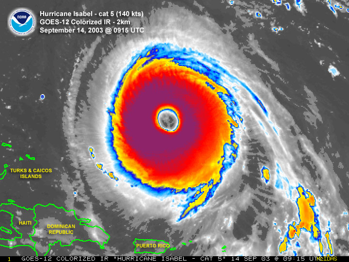
It isn't looking annular. Annular is one of the most widely misapplied terms on this board, and weather boards generally (often used to mean "symmetrical" generally); an annular hurricane features a donut of convection around a large eye, with no banding features and little to no convection outside of the central dense overcast. It also isn't the structure most associated with extreme intensity and you'd be unlikely to find an annular hurricane over the Gulf; rather, annular hurricanes take on their unique structure due to modest, rather than extremely warm, SSTs (typically between 25.4 and 28.5 C).
An annular hurricane looks like this:
(Super Typhoon Nestor)
https://upload.wikimedia.org/wikipedia/commons/9/9e/Typhoon_Nestor_%281997%29.gif
(Hurricane Isabel)
https://pbs.twimg.com/media/EfPDtOaWsAgf6VM.png
(Hurricane Daniel)
https://upload.wikimedia.org/wikipedia/commons/e/ec/Hurricane_Daniel_peak.jpg
It's a very specific structure.
Those are bottomed out annular cyclones, Laura isn't there yet. Not a good comparison at all
Annular hurricanes usually are strong hurricanes, so it's difficult to make any other comparison; it's a specific, unique structure some major hurricanes adopt when they have to make do with modest SSTs. Laura has convection outside of its CDO (it isn't a simple tire-shaped or donut-shaped ring of convection), its eye isn't particularly large compared to its CDO (indeed its eye is on the smaller side), it has rainbands, it's not that symmetrical yet (convection is lopsided to the east), its cloudtops are cold (annular hurricanes tend to have fairly warm cloudtops and fairly shallow, uniform convection for their intensity), and the SSTs wouldn't predict a transition into an annular hurricane (SSTs are too warm; annular hurricanes occur within a fairly narrow range of modest SSTs).
4 likes
You know you're a hurricane nut, when your main source of adrenaline is reading old hurricane advisories...
Re: ATL: LAURA - Hurricane - Discussion
supercane4867 wrote:This is likely off.
956mb and and 954.4 we reported in the previous data set. Not off but likely above the surface so they will call it ~955mb at the surface.
Air Force recon is about to do another eye pass, we will see if it verifies.
1 likes
-
jlauderdal
- S2K Supporter
- Posts: 7240
- Joined: Wed May 19, 2004 5:46 am
- Location: NE Fort Lauderdale
- Contact:
Re: ATL: LAURA - Hurricane - Discussion
There is minimal shear in the forecast prior to landfall but it will have negligible effect on this sytemUSTropics wrote:supercane4867 wrote:NOAA plane doing loops and loops in the eye...
That's typical in an intense hurricane. They will fly around in the center and use radar onboard to find a "clean" way out (there's a lot more complications when flying into an intense and strengthening system). They also will do this when they're staging a lot of dropsondes.
0 likes
-
Kingarabian
- S2K Supporter
- Posts: 16351
- Joined: Sat Aug 08, 2009 3:06 am
- Location: Honolulu, Hawaii
Re: ATL: LAURA - Hurricane - Discussion
HurricaneEdouard wrote:cfisher wrote:HurricaneEdouard wrote:It isn't looking annular. Annular is one of the most widely misapplied terms on this board, and weather boards generally (often used to mean "symmetrical" generally); an annular hurricane features a donut of convection around a large eye, with no banding features and little to no convection outside of the central dense overcast. It also isn't the structure most associated with extreme intensity and you'd be unlikely to find an annular hurricane over the Gulf; rather, annular hurricanes take on their unique structure due to modest, rather than extremely warm, SSTs (typically between 25.4 and 28.5 C).
An annular hurricane looks like this:
(Super Typhoon Nestor)
https://upload.wikimedia.org/wikipedia/commons/9/9e/Typhoon_Nestor_%281997%29.gif
(Hurricane Isabel)
https://pbs.twimg.com/media/EfPDtOaWsAgf6VM.png
(Hurricane Daniel)
https://upload.wikimedia.org/wikipedia/commons/e/ec/Hurricane_Daniel_peak.jpg
It's a very specific structure.
Those are bottomed out annular cyclones, Laura isn't there yet. Not a good comparison at all
Annular hurricanes usually are strong hurricanes, so it's difficult to make any other comparison; it's a specific, unique structure some major hurricanes adopt when they have to make do with modest SSTs. Laura has convection outside of its CDO (it isn't a simple tire-shaped or donut-shaped ring of convection), its eye isn't particularly large compared to its CDO (indeed its eye is on the smaller side), it has rainbands, it's not that symmetrical yet (convection is lopsided to the east), its cloudtops are cold (annular hurricanes tend to have fairly warm cloudtops and fairly shallow, uniform convection for their intensity), and the SSTs wouldn't predict a transition into an annular hurricane (SSTs are too warm; annular hurricanes occur within a fairly narrow range of modest SSTs).
Yeah rather than an annular term people should use buzzsaw. Buzzsaw hurricanes also have less banding but are not annular. The true magic of annular hurricanes is out in the open waters, and not in the GOM.
4 likes
RIP Kobe Bryant
Re: ATL: LAURA - Hurricane - Discussion
Keep an eye on the number of meso-vorts in the eye when Vis comes up.
A large number means a weak TC and possibly undergoing EWRC.
A small number means a very powerful TC.
A large number means a weak TC and possibly undergoing EWRC.
A small number means a very powerful TC.
2 likes
Who is online
Users browsing this forum: No registered users and 4 guests