Central Atlantic Tropical Wave (Is Invest 91L)

This is the general tropical discussion area. Anyone can take their shot at predicting a storms path.

Moderator: S2k Moderators

Forum rules

The posts in this forum are NOT official forecasts and should not be used as such. They are just the opinion of the poster and may or may not be backed by sound meteorological data. They are NOT endorsed by any professional institution or STORM2K. For official information, please refer to products from the National Hurricane Center and National Weather Service.

Help Support Storm2K
Message
Author
User avatar
Cpv17
Category 5
Category 5
Posts: 4979
Joined: Wed Dec 07, 2016 2:24 pm
Location: Wharton/El Campo, TX

Re: Strong Wave to Emerge from Africa today: latest EPS active near CONUS/Bahamas

#61 Postby Cpv17 » Wed Aug 26, 2020 11:21 am

StPeteMike wrote:
Cpv17 wrote:I have a question guys and this probably isn’t the right place to ask this but I was wondering how long would it take for water to recover after a major passes through it?

It depends on where the water is. Around the Gulf and Bahamas area, some areas in the Caribbean as well, it will take a few days to get the temperatures back to where it was before any storm. This is because the waters there are more shallow than the deep waters of the Atlantic. Even so, the Gulf will still be in reasonable temperature range to allow another storm to go over it without weakening, maybe just not such rapid strengthening like with Laura. By this storm reaches the Gulf, if that’s where it ends up, the temperatures will be back to where they were before Marco and Laura.


Exactly what I was wondering. Thank you!
0 likes   

User avatar
SFLcane
S2K Supporter
S2K Supporter
Posts: 10163
Age: 47
Joined: Sat Jun 05, 2010 1:44 pm
Location: Lake Worth Florida

Re: Strong Wave to Emerge from Africa today: latest EPS active near CONUS/Bahamas

#62 Postby SFLcane » Wed Aug 26, 2020 11:31 am

Convection on the increase...

Image
2 likes   

User avatar
Cpv17
Category 5
Category 5
Posts: 4979
Joined: Wed Dec 07, 2016 2:24 pm
Location: Wharton/El Campo, TX

Re: Strong Wave to Emerge from Africa today: latest EPS active near CONUS/Bahamas

#63 Postby Cpv17 » Wed Aug 26, 2020 11:53 am

SFLcane wrote:Convection on the increase...

https://i.imgur.com/R9YUHeV.png


I’ve noticed that the stronger the models initialize a storm, the more ensemble support it usually has. Has that always been the case or is that just something going on this year?
0 likes   

User avatar
SFLcane
S2K Supporter
S2K Supporter
Posts: 10163
Age: 47
Joined: Sat Jun 05, 2010 1:44 pm
Location: Lake Worth Florida

Re: Strong Wave to Emerge from Africa today: latest EPS active near CONUS/Bahamas

#64 Postby SFLcane » Wed Aug 26, 2020 12:47 pm

A westward moving tropical wave is expected to move off of the west
coast of Africa tonight. Although environmental conditions do not
appear to be conducive for development as the wave crosses the
eastern Atlantic over the next few days, conditions could become
more favorable for slow development of the system as it reaches the
central and western tropical Atlantic early next week.
* Formation chance through 48 hours...low...near 0 percent.
* Formation chance through 5 days...low...20 percent.
2 likes   

User avatar
ouragans
Category 1
Category 1
Posts: 490
Age: 53
Joined: Sun Jun 12, 2011 12:09 pm
Location: Abymes, Guadeloupe F.W.I
Contact:

Re: Strong Wave to Emerge from Africa today: latest EPS active near CONUS/Bahamas

#65 Postby ouragans » Wed Aug 26, 2020 1:01 pm

Isn't there a problem with the 5-days image?
0 likes   
Personal forecast disclaimer
This post is a personal point of view, not an information. Please refer to official statements for life-threatening decisions.

David '79, Frederic '79, Hugo '89, Iris, Luis & Marilyn '95, Georges '98, Lenny '99, Dean '07, Irma '17, Maria '17, Fiona '22, Philippe '23, Tammy '23
16°13'33.3,"6N -61°36'39.5"W

User avatar
SouthFLTropics
Category 5
Category 5
Posts: 4236
Age: 50
Joined: Thu Aug 14, 2003 8:04 am
Location: Port St. Lucie, Florida

Re: Strong Wave to Emerge from Africa today: latest EPS active near CONUS/Bahamas

#66 Postby SouthFLTropics » Wed Aug 26, 2020 1:08 pm

SFLcane wrote:A westward moving tropical wave is expected to move off of the west
coast of Africa tonight. Although environmental conditions do not
appear to be conducive for development as the wave crosses the
eastern Atlantic over the next few days, conditions could become
more favorable for slow development of the system as it reaches the
central and western tropical Atlantic early next week.
* Formation chance through 48 hours...low...near 0 percent.
* Formation chance through 5 days...low...20 percent.

Wash, rinse, repeat...same story over and over again. Slow to develop until it gets farther west.


Sent from my iPhone using Tapatalk
3 likes   
Fourth Generation Florida Native

Personal Storm History: David 79, Andrew 92, Erin 95, Floyd 99, Irene 99, Frances 04, Jeanne 04, Wilma 05, Matthew 16, Irma 17, Ian 22, Nicole 22, Milton 24

User avatar
SFLcane
S2K Supporter
S2K Supporter
Posts: 10163
Age: 47
Joined: Sat Jun 05, 2010 1:44 pm
Location: Lake Worth Florida

Re: Strong Wave to Emerge from Africa today: latest EPS active near CONUS/Bahamas

#67 Postby SFLcane » Wed Aug 26, 2020 1:12 pm

Image
0 likes   

User avatar
Cpv17
Category 5
Category 5
Posts: 4979
Joined: Wed Dec 07, 2016 2:24 pm
Location: Wharton/El Campo, TX

Re: Strong Wave to Emerge from Africa today: latest EPS active near CONUS/Bahamas

#68 Postby Cpv17 » Wed Aug 26, 2020 1:16 pm


That seems to be the same general region that Laura tracked over and started getting her act together and we all know how that turned out.
0 likes   

User avatar
EquusStorm
Category 5
Category 5
Posts: 1649
Age: 34
Joined: Thu Nov 07, 2013 1:04 pm
Location: Jasper, AL
Contact:

Re: Strong Wave to Emerge from Africa today: latest EPS active near CONUS/Bahamas

#69 Postby EquusStorm » Wed Aug 26, 2020 1:18 pm

Yeahhh that is NOT a good trend. 2005-eqsue homegrown storms rapidly ramping up approaching land rather than a 1995/2010-esque recurve fest. The dry air certainly may make things WORSE for us.
4 likes   
Colors of lost purpose on the canvas of irrelevance

Not a meteorologist, in fact more of an idiot than anything. You should probably check with the NHC or a local NWS office for official information.

User avatar
Cpv17
Category 5
Category 5
Posts: 4979
Joined: Wed Dec 07, 2016 2:24 pm
Location: Wharton/El Campo, TX

Re: Strong Wave to Emerge from Africa today: latest EPS active near CONUS/Bahamas

#70 Postby Cpv17 » Wed Aug 26, 2020 1:58 pm

EquusStorm wrote:Yeahhh that is NOT a good trend. 2005-eqsue homegrown storms rapidly ramping up approaching land rather than a 1995/2010-esque recurve fest. The dry air certainly may make things WORSE for us.


Look at the ridging on the latest Euro. That’s crazy! Sends this wave into south Texas.
0 likes   

User avatar
CyclonicFury
Category 5
Category 5
Posts: 2025
Age: 26
Joined: Sun Jul 02, 2017 12:32 pm
Location: NC
Contact:

Re: Strong Wave to Emerge from Africa today: latest EPS active near CONUS/Bahamas

#71 Postby CyclonicFury » Wed Aug 26, 2020 2:00 pm

The 12z operational ECMWF doesn't develop this, but after it going through phases where it didn't develop pre-Isaias or pre-Laura (and it never really developed pre-Marco at all), its model output is questionable considering the time of year. I wouldn't bet on it being quiet for the next 10 days after Laura.
4 likes   
NCSU B.S. in Meteorology Class of 2021. Tropical weather blogger at http://www.cyclonicfury.com. My forecasts and thoughts are NOT official, for official forecasts please consult the National Hurricane Center.

HuracanMaster
Tropical Low
Tropical Low
Posts: 45
Joined: Sat Aug 08, 2020 11:20 am

Re: RE: Re: Strong Wave to Emerge from Africa today: latest EPS active near CONUS/Bahamas

#72 Postby HuracanMaster » Wed Aug 26, 2020 4:16 pm

CyclonicFury wrote:The 12z operational ECMWF doesn't develop this, but after it going through phases where it didn't develop pre-Isaias or pre-Laura (and it never really developed pre-Marco at all), its model output is questionable considering the time of year. I wouldn't bet on it being quiet for the next 10 days after Laura.
My thoughts exactly. We are nearing the peak
and this will be in the middle of it!

Sent from my SM-G975U using Tapatalk
0 likes   

User avatar
gatorcane
S2K Supporter
S2K Supporter
Posts: 23691
Age: 47
Joined: Sun Mar 13, 2005 3:54 pm
Location: Boca Raton, FL

Re: Strong Wave to Emerge from Africa today: latest EPS active near CONUS/Bahamas

#73 Postby gatorcane » Wed Aug 26, 2020 5:14 pm

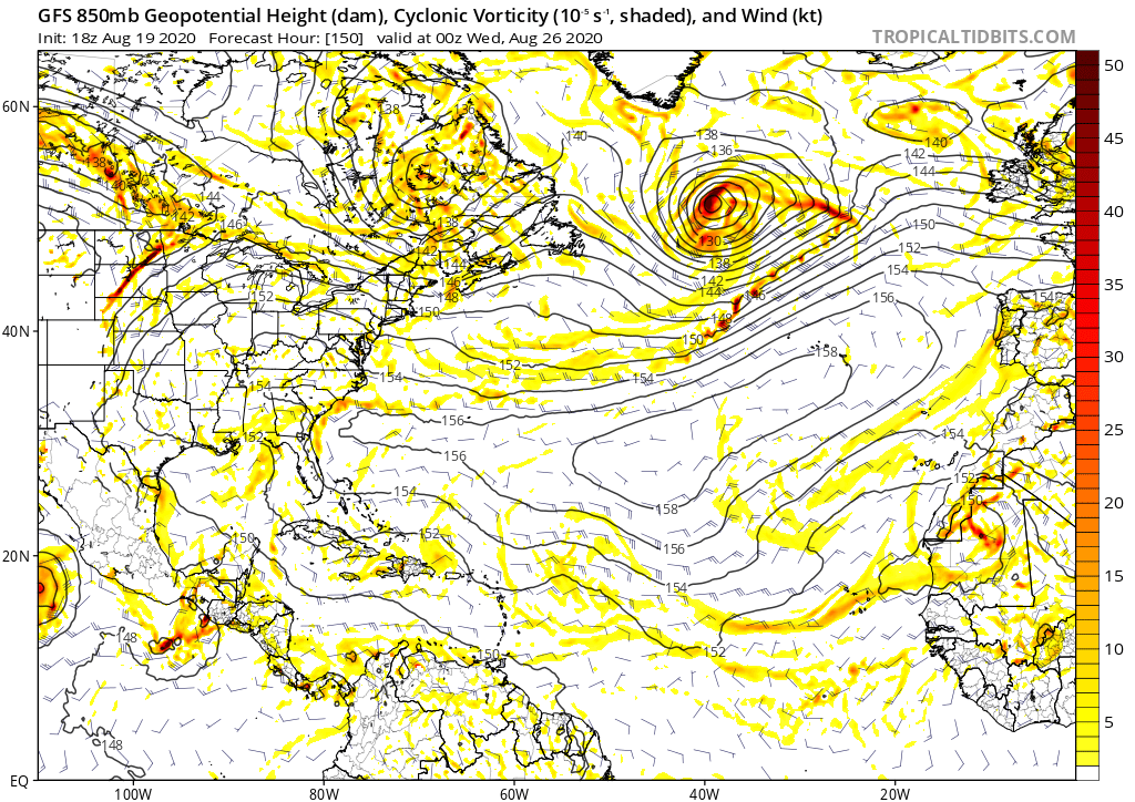
Here is what the 18Z Aug 19th GFS run showed for today’s forecast (7 days out): :eek:

Image
7 likes   

User avatar
toad strangler
S2K Supporter
S2K Supporter
Posts: 4543
Joined: Sun Jul 28, 2013 3:09 pm
Location: Earth
Contact:

Re: Strong Wave to Emerge from Africa today: latest EPS active near CONUS/Bahamas

#74 Postby toad strangler » Wed Aug 26, 2020 5:18 pm


Interesting that there is a lemon present on this map from the Lesser Antilles on East. Had to be a mistake. There’s nothing there.
0 likes   

AutoPenalti
Category 5
Category 5
Posts: 4030
Age: 29
Joined: Mon Aug 17, 2015 4:16 pm
Location: Ft. Lauderdale, Florida

Re: Strong Wave to Emerge from Africa today: latest EPS active near CONUS/Bahamas

#75 Postby AutoPenalti » Wed Aug 26, 2020 5:20 pm

toad strangler wrote:


Interesting that there is a lemon present on this map East of the Lesser Antilles. Had to be a mistake. There’s nothing there.

That’s their 5-day outlook. There’s a 20% chance of development in that area within 5 days.
3 likes   
The posts in this forum are NOT official forecasts and should not be used as such. They are just the opinion of the poster and may or may not be backed by sound meteorological data. They are NOT endorsed by any professional institution or STORM2K. For official information, please refer to products from the NHC and NWS.


Model Runs Cheat Sheet:
GFS (5:30 AM/PM, 11:30 AM/PM)
HWRF, GFDL, UKMET, NAVGEM (6:30-8:00 AM/PM, 12:30-2:00 AM/PM)
ECMWF (1:45 AM/PM)

TCVN
is a weighted averaged

User avatar
gatorcane
S2K Supporter
S2K Supporter
Posts: 23691
Age: 47
Joined: Sun Mar 13, 2005 3:54 pm
Location: Boca Raton, FL

Re: Strong Wave to Emerge from Africa today: latest EPS active near CONUS/Bahamas

#76 Postby gatorcane » Wed Aug 26, 2020 5:21 pm

toad strangler wrote:


Interesting that there is a lemon present on this map from the Lesser Antilles on East. Had to be a mistake. There’s nothing there.


From the outlook, that is where development would be possible but maybe they should have put an X over the wave near Africa and drawn an arrow to the shaded area.
2 likes   

User avatar
Cpv17
Category 5
Category 5
Posts: 4979
Joined: Wed Dec 07, 2016 2:24 pm
Location: Wharton/El Campo, TX

Re: Strong Wave to Emerge from Africa today: latest EPS active near CONUS/Bahamas

#77 Postby Cpv17 » Wed Aug 26, 2020 5:22 pm

gatorcane wrote:Here is what the 18Z Aug 19th GFS run showed for today’s forecast (7 days out): :eek:

https://i.postimg.cc/fbzS3Qjx/gfs-z850-vort-atl-26.png


You still love the GFS? :lol: I must add that the Euro wasn’t any better though.
Last edited by Cpv17 on Wed Aug 26, 2020 5:27 pm, edited 1 time in total.
2 likes   

User avatar
toad strangler
S2K Supporter
S2K Supporter
Posts: 4543
Joined: Sun Jul 28, 2013 3:09 pm
Location: Earth
Contact:

Re: Strong Wave to Emerge from Africa today: latest EPS active near CONUS/Bahamas

#78 Postby toad strangler » Wed Aug 26, 2020 5:22 pm

Got it. Thx gents!
0 likes   

User avatar
cycloneye
Admin
Admin
Posts: 145308
Age: 68
Joined: Thu Oct 10, 2002 10:54 am
Location: San Juan, Puerto Rico

Re: Strong Wave to Emerge from Africa today: latest EPS active near CONUS/Bahamas

#79 Postby cycloneye » Wed Aug 26, 2020 6:54 pm

A westward-moving tropical wave located just off the west coast of
Africa about 400 miles east-southeast of the Cabo Verde Islands is
producing disorganized shower activity. Although environmental
conditions are not expected to be conducive for development during
the next couple of days, they are forecast to gradually become more
favorable over the weekend and into early next week when the wave
moves into the central and western tropical Atlantic.
* Formation chance through 48 hours...low...near 0 percent.
* Formation chance through 5 days...low...20 percent.

Forecaster Stewart


Image
2 likes   
Visit the Caribbean-Central America Weather Thread where you can find at first post web cams,radars
and observations from Caribbean basin members Click Here

User avatar
AnnularCane
S2K Supporter
S2K Supporter
Posts: 2862
Joined: Thu Jun 08, 2006 9:18 am
Location: Wytheville, VA

Re: Strong Wave to Emerge from Africa today: latest EPS active near CONUS/Bahamas

#80 Postby AnnularCane » Wed Aug 26, 2020 7:03 pm

That's better. It looked incomplete without the X. :wink:
4 likes   


Return to “Talkin' Tropics”

Who is online

Users browsing this forum: HurricaneFan, USTropics, WaveBreaking and 39 guests