NDG wrote:What in the world went on during the past 24 hrs about a deep trough in the GFS's 10+ day range,
You should know better than that.
http://twitter.com/BenNollWeather/status/1299697057293271040
Moderator: S2k Moderators


NDG wrote:What in the world went on during the past 24 hrs about a deep trough in the GFS's 10+ day range,
You should know better than that.


toad strangler wrote:NDG wrote:What in the world went on during the past 24 hrs about a deep trough in the GFS's 10+ day range,
You should know better than that.
http://twitter.com/BenNollWeather/status/1299697057293271040?s=20
SFLcane wrote:NDG wrote:What in the world went on during the past 24 hrs about a deep trough in the GFS's 10+ day range,
You should know better than that.
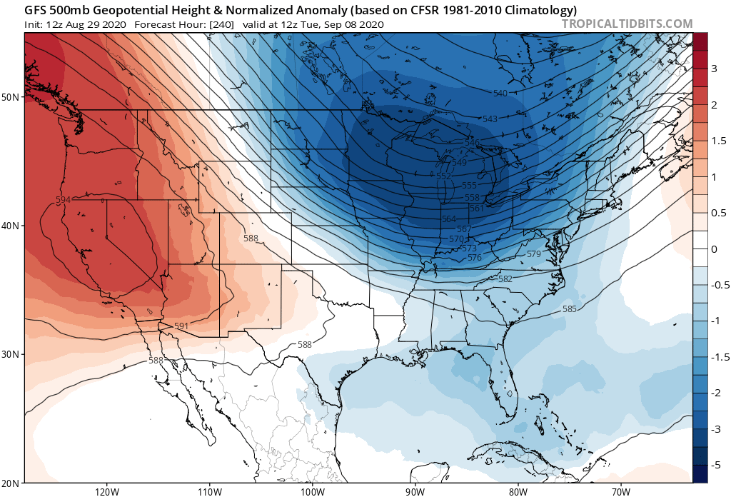
Here's the GFS a few days ago showing a deep trough in the NE US early next week in its 10 day range.
https://i.imgur.com/70O4tWr.png
Here's the short range GFS, where's the trough?
https://i.imgur.com/zezFGrI.png
Plus something else to think about, even if a deep trough comes down the GLs/NE US into the MS river valley like the last one did a few days ago, if they do not keep progressing eastward the strong Atlantic/Bermuda ridge will still be taking hold just off of the US coast keeping the threat to at least the eastern US from tropical systems.
https://i.imgur.com/XJsbJ9f.gif
We shall see... Just gotta keep an eye on it.
With the recurving typhoons, you get a ridge->trough->ridge->trough pattern. Like Isaias/Irene/Floyd
NDG wrote:SFLcane wrote:NDG wrote:What in the world went on during the past 24 hrs about a deep trough in the GFS's 10+ day range,
You should know better than that.
Here's the GFS a few days ago showing a deep trough in the NE US early next week in its 10 day range.
https://i.imgur.com/70O4tWr.png
Here's the short range GFS, where's the trough?
https://i.imgur.com/zezFGrI.png
Plus something else to think about, even if a deep trough comes down the GLs/NE US into the MS river valley like the last one did a few days ago, if they do not keep progressing eastward the strong Atlantic/Bermuda ridge will still be taking hold just off of the US coast keeping the threat to at least the eastern US from tropical systems.
https://i.imgur.com/XJsbJ9f.gif
We shall see... Just gotta keep an eye on it.
With the recurving typhoons, you get a ridge->trough->ridge->trough pattern. Like Isaias/Irene/Floyd
Which all 3 of them made landfall in the eastern US.
I just don't see a OTS pattern setting up like in 2010 & 2011 as some are trying to indicate.

toad strangler wrote:NDG wrote:What in the world went on during the past 24 hrs about a deep trough in the GFS's 10+ day range,
You should know better than that.
http://twitter.com/BenNollWeather/status/1299697057293271040?s=20
Shell Mound wrote:toad strangler wrote:NDG wrote:What in the world went on during the past 24 hrs about a deep trough in the GFS's 10+ day range,
You should know better than that.
http://twitter.com/BenNollWeather/status/1299697057293271040?s=20
Note that the GFS Parallel has also been consistently far more reliable than the GFS itself thus far in 2020. Besides the upcoming synoptic pattern, I would also argue that the “clustering” of tracks strongly supports potential TC threats to the Carolinas, Mid-Atlantic, and/or New England sometime in mid-September. For example, besides the numerous impacts in TX and LA (northwestern Gulf Coast), principally Cristobal, Hanna, Laura, and Marco, we have already seen three or more TS+ impacts from SC to NY, including Bertha, Fay, and Isaias. A strong, negatively tilted trough centred over the Great Lakes with equally strong blocking just off the Eastern Seaboard—namely, centred near the Canadian Maritimes—would definitely support the notion of additional threats to the aforementioned region(s). The western Gulf and the Carolinas/Mid-Atlantic/New England definitely seem to be the preferred “hotspots” for U.S. impacts in 2020.

SFLcane wrote:If the West Atlantic ridge holds to some extent, you could see a storm moving S->N along the East Coast.


SFLcane wrote:Something is just off about this season.

SFLcane wrote:Something is just off about this season.
NDG wrote:Shell Mound wrote:
Note that the GFS Parallel has also been consistently far more reliable than the GFS itself thus far in 2020. Besides the upcoming synoptic pattern, I would also argue that the “clustering” of tracks strongly supports potential TC threats to the Carolinas, Mid-Atlantic, and/or New England sometime in mid-September. For example, besides the numerous impacts in TX and LA (northwestern Gulf Coast), principally Cristobal, Hanna, Laura, and Marco, we have already seen three or more TS+ impacts from SC to NY, including Bertha, Fay, and Isaias. A strong, negatively tilted trough centred over the Great Lakes with equally strong blocking just off the Eastern Seaboard—namely, centred near the Canadian Maritimes—would definitely support the notion of additional threats to the aforementioned region(s). The western Gulf and the Carolinas/Mid-Atlantic/New England definitely seem to be the preferred “hotspots” for U.S. impacts in 2020.
I agree, the troughs that have come have been negatively positioned still giving the US a threat because ridging across the Atlantic has stayed present more often than not.
So just because a strong trough may come down the US in about 10 days it does not mean many if any OTS tracks setting up. The only ones that I may see going OTS are the ones that may develop strong sooner just off of the CV Islands, eventually once the SAL outbreaks settle down and they track through a break in the ridge in the middle or eastern Atlantic.
Users browsing this forum: USTropics and 323 guests


