For those using the GFS model as a barometer for increased activity as we are heading into September - BE CAREFUL!
It's done horribly this season with tropical cyclone genesis forecasts. Use the ensembles or better yet, use the newer GFS Parallel ensemble guidance (it's done well with genesis forecasts this season - I've been keeping track).
So, what does the GFS parallel ensemble guidance show - There's a signal for a tropical system to form in the Bahamas in about 10 days from now & a signal that shows the SW North Atlantic may be active between the 10th and 16th of September.
2020 Global Model Runs Discussion (Out thru day 16)
Moderator: S2k Moderators
Forum rules

The posts in this forum are NOT official forecasts and should not be used as such. They are just the opinion of the poster and may or may not be backed by sound meteorological data. They are NOT endorsed by any professional institution or STORM2K. For official information, please refer to products from the National Hurricane Center and National Weather Service.
-
crownweather

- S2K Supporter

- Posts: 602
- Age: 51
- Joined: Sat Aug 12, 2006 9:21 am
- Location: Sturbridge, Massachusetts
- Contact:
Re: 2020 Global Model Runs Discussion (Out thru day 16)
4 likes
Rob Lightbown
Crown Weather Services
https://crownweather.com
Crown Weather Services
https://crownweather.com
-
SFLcane

- S2K Supporter
- Posts: 10281
- Age: 48
- Joined: Sat Jun 05, 2010 1:44 pm
- Location: Lake Worth Florida
Re: 2020 Global Model Runs Discussion (Out thru day 16)
I don't think we'll get shut out on long trackers this year Just may not be right when we expect.

0 likes

Re: 2020 Global Model Runs Discussion (Out thru day 16)
crownweather wrote:For those using the GFS model as a barometer for increased activity as we are heading into September - BE CAREFUL!
It's done horribly this season with tropical cyclone genesis forecasts. Use the ensembles or better yet, use the newer GFS Parallel ensemble guidance (it's done well with genesis forecasts this season - I've been keeping track).
So, what does the GFS parallel ensemble guidance show - There's a signal for a tropical system to form in the Bahamas in about 10 days from now & a signal that shows the SW North Atlantic may be active between the 10th and 16th of September.
The GFS-Para has also developed 99L and been consistent about at least a strong TS forming in the MDR sometime within the next 5-10 days. In the long range 06z run, it has a storm in the Gulf and yet another MDR hurricane.
2 likes
Irene '11 Sandy '12 Hermine '16 5/15/2018 Derecho Fay '20 Isaias '20 Elsa '21 Henri '21 Ida '21
I am only a meteorology enthusiast who knows a decent amount about tropical cyclones. Look to the professional mets, the NHC, or your local weather office for the best information.
I am only a meteorology enthusiast who knows a decent amount about tropical cyclones. Look to the professional mets, the NHC, or your local weather office for the best information.
-
MarioProtVI
- Category 5

- Posts: 1034
- Age: 24
- Joined: Sun Sep 29, 2019 7:33 pm
- Location: New Jersey
Re: 2020 Global Model Runs Discussion (Out thru day 16)
aspen wrote:crownweather wrote:For those using the GFS model as a barometer for increased activity as we are heading into September - BE CAREFUL!
It's done horribly this season with tropical cyclone genesis forecasts. Use the ensembles or better yet, use the newer GFS Parallel ensemble guidance (it's done well with genesis forecasts this season - I've been keeping track).
So, what does the GFS parallel ensemble guidance show - There's a signal for a tropical system to form in the Bahamas in about 10 days from now & a signal that shows the SW North Atlantic may be active between the 10th and 16th of September.
The GFS-Para has also developed 99L and been consistent about at least a strong TS forming in the MDR sometime within the next 5-10 days. In the long range 06z run, it has a storm in the Gulf and yet another MDR hurricane.
Is it better to trust the GFS-parallel itself then the operational GFS, which has performed horribly this year? Has it done better with genesis then the other? Would like to know.
0 likes
-
crownweather
- S2K Supporter
- Posts: 602
- Age: 51
- Joined: Sat Aug 12, 2006 9:21 am
- Location: Sturbridge, Massachusetts
- Contact:
Re: 2020 Global Model Runs Discussion (Out thru day 16)
MarioProtVI wrote:aspen wrote:crownweather wrote:For those using the GFS model as a barometer for increased activity as we are heading into September - BE CAREFUL!
It's done horribly this season with tropical cyclone genesis forecasts. Use the ensembles or better yet, use the newer GFS Parallel ensemble guidance (it's done well with genesis forecasts this season - I've been keeping track).
So, what does the GFS parallel ensemble guidance show - There's a signal for a tropical system to form in the Bahamas in about 10 days from now & a signal that shows the SW North Atlantic may be active between the 10th and 16th of September.
The GFS-Para has also developed 99L and been consistent about at least a strong TS forming in the MDR sometime within the next 5-10 days. In the long range 06z run, it has a storm in the Gulf and yet another MDR hurricane.
Is it better to trust the GFS-parallel itself then the operational GFS, which has performed horribly this year? Has it done better with genesis then the other? Would like to know.
For the limited time the GFS-Parallel model has been run (not being run all the time), I think it's done far better with picking out areas to watch out for. The GFS-Parallel ensembles, which seems to be run all the time now has done great with picking out genesis & seems to be doing better than the Euro ensembles!
0 likes
Rob Lightbown
Crown Weather Services
https://crownweather.com
Crown Weather Services
https://crownweather.com

Re: 2020 Global Model Runs Discussion (Out thru day 16)
crownweather wrote:MarioProtVI wrote:aspen wrote:The GFS-Para has also developed 99L and been consistent about at least a strong TS forming in the MDR sometime within the next 5-10 days. In the long range 06z run, it has a storm in the Gulf and yet another MDR hurricane.
Is it better to trust the GFS-parallel itself then the operational GFS, which has performed horribly this year? Has it done better with genesis then the other? Would like to know.
For the limited time the GFS-Parallel model has been run (not being run all the time), I think it's done far better with picking out areas to watch out for. The GFS-Parallel ensembles, which seems to be run all the time now has done great with picking out genesis & seems to be doing better than the Euro ensembles!
Odd but true. I've noticed the same thing lately.
0 likes
Andy D
(For official information, please refer to the NHC and NWS products.)
(For official information, please refer to the NHC and NWS products.)

Re: 2020 Global Model Runs Discussion (Out thru day 16)
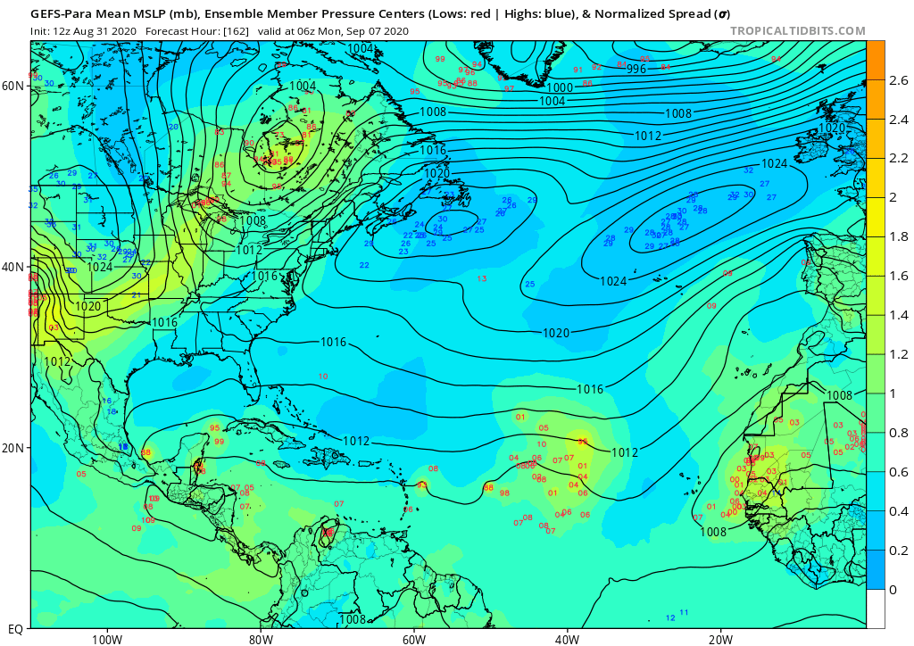
ICON has a few systems in the next 10 days. First low forms off the SEUS coast. It's ambiguous what happens with the WCar low as it partially spins down on the Mexican Riviera and partially angles isobars toward Brownsville. It's got some stupid Fujiwara thing going on in the E-Atl with the first two systems before showing 2 systems developing out there.
https://www.tropicaltidbits.com/analysi ... 3112&fh=90
Parallel GFS (06z) has much the same as ICON though less pronounced off the SEUS coast. It also brings a storm out of the Bay of Campeche and hits slightly east of where Laura did as a Cat 2 (or possibly a 3) around 1am 2 weeks from tomorrow. If that verifies I'm not going to eat a hat, but I would be surprised.
https://www.tropicaltidbits.com/analysi ... 83106&fh=6
1 likes
-
gatorcane

- S2K Supporter
- Posts: 23708
- Age: 48
- Joined: Sun Mar 13, 2005 3:54 pm
- Location: Boca Raton, FL
Re: 2020 Global Model Runs Discussion (Out thru day 16)
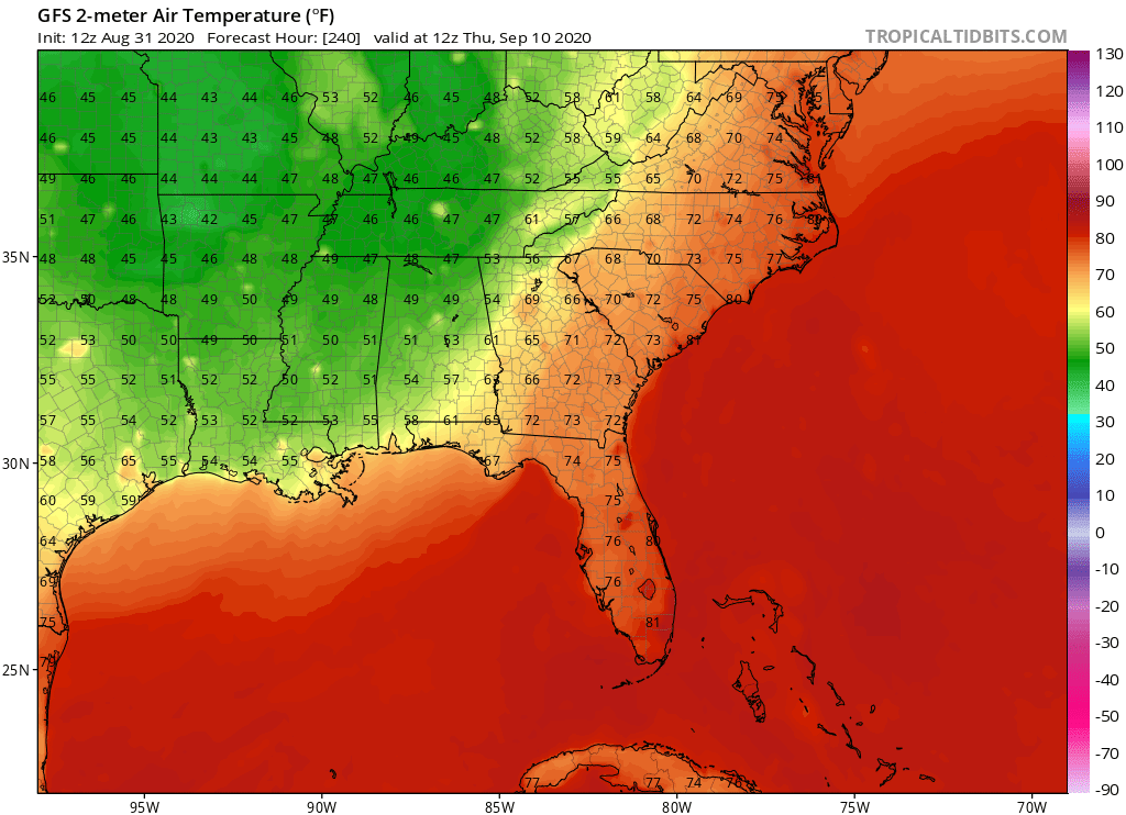
If the GFS trough verifies, and that is a big if, looks like we could see some of the SSTs cool down along the northern Gulf coast with lows in the mid 50s:
0 likes
-
Ivanhater

- Storm2k Moderator

- Posts: 11221
- Age: 39
- Joined: Fri Jul 01, 2005 8:25 am
- Location: Pensacola
Re: 2020 Global Model Runs Discussion (Out thru day 16)
gatorcane wrote:If the GFS trough verifies, and that is a big if, looks like we could see some of the SSTs cool down along the northern Gulf coast with lows in the mid 50s:
https://i.postimg.cc/X7KHchxf/gfs-T2m-seus-41.png
Unless there are sustained and multiple cold fronts I doubt anything will cool substantially or for that long. We always have 1 or 2 during the summer like 2018 and we saw a category 5 in October
3 likes
Michael
-
cheezyWXguy

- Category 5
- Posts: 6282
- Joined: Mon Feb 13, 2006 12:29 am
- Location: Dallas, TX
Re: 2020 Global Model Runs Discussion (Out thru day 16)
GFS Para seems intent on destroying everything in SW LA that Laura missed, with another major landfall. Along with a strengthening hurricane north of the lesser Antilles of course. If you’re looking for a global model with a decent track record that consistently shows something, this is one of them.
1 likes
-
TheStormExpert
Re: 2020 Global Model Runs Discussion (Out thru day 16)
00z EPS seems to be lighting up again for what it’s worth.
https://twitter.com/jpkassell/status/1300452851290902535
https://twitter.com/jpkassell/status/1300452851290902535
0 likes
-
gatorcane
- S2K Supporter
- Posts: 23708
- Age: 48
- Joined: Sun Mar 13, 2005 3:54 pm
- Location: Boca Raton, FL
Re: 2020 Global Model Runs Discussion (Out thru day 16)
cheezyWXguy wrote:GFS Para seems intent on destroying everything in SW LA that Laura missed, with another major landfall. Along with a strengthening hurricane north of the lesser Antilles of course. If you’re looking for a global model with a decent track record that consistently shows something, this is one of them.
Those storms are way out in the long-range and the GFS para as far as I am concerned seems too eager to develop things. The ensembles could be a better bet and they show some possibilities in the MDR over the Atlantic.
1 likes
Re: 2020 Global Model Runs Discussion (Out thru day 16)
The three most reliable models this year for cyclogenesis — the CMC, ICON, and GFS-Para — as well as the EPS are all showing development in the eastern MDR by late this week. Depending on how this comes out, it could be the long-tracking MDR hurricane we’ve been anticipating. If not, the wave behind it could become one.
2 likes
Irene '11 Sandy '12 Hermine '16 5/15/2018 Derecho Fay '20 Isaias '20 Elsa '21 Henri '21 Ida '21
I am only a meteorology enthusiast who knows a decent amount about tropical cyclones. Look to the professional mets, the NHC, or your local weather office for the best information.
I am only a meteorology enthusiast who knows a decent amount about tropical cyclones. Look to the professional mets, the NHC, or your local weather office for the best information.
-
Spacecoast

- Category 2

- Posts: 773
- Joined: Thu Aug 31, 2017 2:03 pm
Re: 2020 Global Model Runs Discussion (Out thru day 16)
aspen wrote:The three most reliable models this year for cyclogenesis — the CMC, ICON, and GFS-Para — as well as the EPS are all showing development in the eastern MDR by late this week. Depending on how this comes out, it could be the long-tracking MDR hurricane we’ve been anticipating. If not, the wave behind it could become one.
Is there a metric, (or scorecard) for cyclogenesis reliability amongst these models?
Accurately predicting cyclogenesis 3-5 days prior to actual genesis is one thing, but inaccurately predicting genesis 3-5 days prior when no genesis occurs should be factored in as a 'false positive', and weighed against the overal 'reliability.'
Just as inaccuratey not predicting cyclogenesis 3-5 days prior must be factored in as a 'false negative'.
It appears to me that the GFS / Euro have an unusually high false negative rate.
It also appears to me that CMC / GFS-Para have a fairly high false positive rate.
Both of these errors are equally important.
After genesis, the GFS-Para does seem to predict many rapid blowups, and unusual stalls near the coast. A couple days back it stalled a major just off the N.O coast for a prolonged period of time.
0 likes
-
cheezyWXguy
- Category 5
- Posts: 6282
- Joined: Mon Feb 13, 2006 12:29 am
- Location: Dallas, TX
Re: 2020 Global Model Runs Discussion (Out thru day 16)
Spacecoast wrote:aspen wrote:The three most reliable models this year for cyclogenesis — the CMC, ICON, and GFS-Para — as well as the EPS are all showing development in the eastern MDR by late this week. Depending on how this comes out, it could be the long-tracking MDR hurricane we’ve been anticipating. If not, the wave behind it could become one.
Is there a metric, (or scorecard) for cyclogenesis reliability amongst these models?
Accurately predicting cyclogenesis 3-5 days prior to actual genesis is one thing, but inaccurately predicting genesis 3-5 days prior when no genesis occurs should be factored in as a 'false positive', and weighed against the overal 'reliability.'
Just as inaccuratey not predicting cyclogenesis 3-5 days prior must be factored in as a 'false negative'.
It appears to me that the GFS / Euro have an unusually high false negative rate.
It also appears to me that CMC / GFS-Para have a fairly high false positive rate.
Both of these errors are equally important.
After genesis, the GFS-Para does seem to predict many rapid blowups, and unusual stalls near the coast. A couple days back it stalled a major just off the N.O coast for a prolonged period of time.
I remember that, very weird track. However, the system that it showed doing that is still depicted, aka the Bahamas system. Although its handling of the system has varied dramatically, the model has shown the system itself at least semi-consistently, and I’ve seen all the systems it currently depicts on other models at one time or another (wgom on gfs and now on euro ensemble), Bahamas system on gfs and cmc, mdr hurricane on just about all of them). I agree it handles those systems inconsistently, but I have yet to see any model that doesn’t contend with the windshield wiper effect in the long range.
I can’t attest to its false positive rate much, but I don’t recall any extended periods this season where the para was locked onto a system for an extended time that just never panned out. On the other hand, a do recall this on the standard gfs for the phantom cag system it depicted in early August. I definitely can acknowledge that I may be missing some cases so far this season that could be altering my perception though.
0 likes
-
cainjamin

- Tropical Storm

- Posts: 173
- Age: 34
- Joined: Mon Apr 17, 2017 1:38 pm
- Location: Nova Scotia, Canada
Re: 2020 Global Model Runs Discussion (Out thru day 16)
The 12Z GFS-Para is still showing a slew of systems developing over the next couple weeks:
Doesn't do much with 90L but it looks like we may also get a storm out of that. It's going to be a busy few weeks it looks like.
- 1. Develops 99L in the Gulf of Honduras
2. Develops the wave about to exit Africa into a hurricane, but dissipates it before it reaches the islands.
3. Develops the following wave into a hurricane with a pretty ominous track approaching the islands at hour 384.
4. Develops a hurricane in the GOM that makes landfall in western Louisiana.
5. Develops what might be the wave currently in the Central Atlantic into a short-lived storm that hits SC.
Doesn't do much with 90L but it looks like we may also get a storm out of that. It's going to be a busy few weeks it looks like.
1 likes
Noel '07, Kyle '08, Earl '10, Arthur '14, Dorian '19, Teddy '20, Lee '23
-
shiny-pebble
- Category 1

- Posts: 299
- Joined: Thu Jul 05, 2018 1:38 pm
Re: RE: Re: 2020 Global Model Runs Discussion (Out thru day 16)
That along with 90L would bring us to Teddy with only 2 names left in 16 days...cainjamin wrote:The 12Z GFS-Para is still showing a slew of systems developing over the next couple weeks:1. Develops 99L in the Gulf of Honduras
2. Develops the wave about to exit Africa into a hurricane, but dissipates it before it reaches the islands.
3. Develops the following wave into a hurricane with a pretty ominous track approaching the islands at hour 384.
4. Develops a hurricane in the GOM that makes landfall in western Louisiana.
5. Develops what might be the wave currently in the Central Atlantic into a short-lived storm that hits SC.
Doesn't do much with 90L but it looks like we may also get a storm out of that. It's going to be a busy few weeks it looks like.
Sent from my SM-G970U using Tapatalk
1 likes
Not an meteorologist! Just someone who is interested in weather. Please refer to the NHC and local weather officials to make decisions.
-Jack
-Jack
Re: RE: Re: 2020 Global Model Runs Discussion (Out thru day 16)
shiny-pebble wrote:That along with 90L would bring us to Teddy with only 2 names left in 16 days...cainjamin wrote:The 12Z GFS-Para is still showing a slew of systems developing over the next couple weeks:1. Develops 99L in the Gulf of Honduras
2. Develops the wave about to exit Africa into a hurricane, but dissipates it before it reaches the islands.
3. Develops the following wave into a hurricane with a pretty ominous track approaching the islands at hour 384.
4. Develops a hurricane in the GOM that makes landfall in western Louisiana.
5. Develops what might be the wave currently in the Central Atlantic into a short-lived storm that hits SC.
Doesn't do much with 90L but it looks like we may also get a storm out of that. It's going to be a busy few weeks it looks like.
Sent from my SM-G970U using Tapatalk
That's as hyperactive as it gets. With a dangerous landfall pattern it's going to be chaotic
0 likes

Re: 2020 Global Model Runs Discussion (Out thru day 16)
TheStormExpert wrote:00z EPS seems to be lighting up again for what it’s worth.
https://twitter.com/jpkassell/status/1300452851290902535
It seems the monsoon gyre being so far north is going to reduce the chances of a long-tracker this year if everything that forms that far east is ending up flung NW over cooler water. But once again the flip side is a much higher chance that those systems either reform or wait to form much further west--leaving no time to miss land.
0 likes
The above post is not official and should not be used as such. It is the opinion of the poster and may or may not be backed by sound meteorological data. It is not endorsed by any professional institution or storm2k.org. For official information, please refer to the NHC and NWS products.
Re: 2020 Global Model Runs Discussion (Out thru day 16)
Hammy wrote:TheStormExpert wrote:00z EPS seems to be lighting up again for what it’s worth.
https://twitter.com/jpkassell/status/1300452851290902535
It seems the monsoon gyre being so far north is going to reduce the chances of a long-tracker this year if everything that forms that far east is ending up flung NW over cooler water. But once again the flip side is a much higher chance that those systems either reform or wait to form much further west--leaving no time to miss land.
With a monster ridge in place I'm willing to bet everything's heading west
1 likes
Who is online
Users browsing this forum: No registered users and 173 guests