2020 Global Model Runs Discussion (Out thru day 16)

This is the general tropical discussion area. Anyone can take their shot at predicting a storms path.

Moderator: S2k Moderators

Forum rules

The posts in this forum are NOT official forecasts and should not be used as such. They are just the opinion of the poster and may or may not be backed by sound meteorological data. They are NOT endorsed by any professional institution or STORM2K. For official information, please refer to products from the National Hurricane Center and National Weather Service.

Help Support Storm2K
Message
Author
User avatar
Spacecoast
Category 2
Category 2
Posts: 758
Joined: Thu Aug 31, 2017 2:03 pm

Re: 2020 Global Model Runs Discussion (Out thru day 16)

#1801 Postby Spacecoast » Mon Aug 31, 2020 7:24 pm

cheezyWXguy wrote:
Spacecoast wrote:Is there a metric, (or scorecard) for cyclogenesis reliability amongst these models?


I can’t attest to its false positive rate much, but I don’t recall any extended periods this season where the para was locked onto a system for an extended time that just never panned out. On the other hand, a do recall this on the standard gfs for the phantom cag system it depicted in early August. I definitely can acknowledge that I may be missing some cases so far this season that could be altering my perception though.


From Dr Masters 8/20/20...
https://yaleclimateconnections.org/2020/08/the-most-reliable-hurricane-models-according-to-their-2019-performance/
"The (2016) study found that skill declined markedly for forecasts beyond two days into the future, and skill was lowest for small tropical cyclones. The European model had the lowest probability of correctly making a genesis forecast – near 20% – but had the fewest false alarms. The GFS correctly made genesis forecasts 20 – 25% of the time, but had more false alarms. The Canadian model had the greatest chance of making a correct genesis forecast, but also had the highest number of false alarms. The take-home message: if the Canadian model is predicting genesis, it is suggestive that something may be afoot, but don’t bet on tropical cyclone genesis until the European model comes on board. In general, when two or more models make the same genesis forecast, the odds of the event actually occurring increase considerably, the study found.

and other genesis links:
FSU Experimental Tropical Cyclone Genesis Guidance Page: http://moe.met.fsu.edu/modelgen/summary120.php
SUNY Albany 10-day Experimental Genesis Probabilities (Alan Brammer): http://www.atmos.albany.edu/facstaff/abrammer/maps/genesis/

****edited, to add correct link to atmos albany experimental genesis
Last edited by Spacecoast on Tue Sep 01, 2020 10:40 am, edited 1 time in total.
2 likes   

Frank2
Category 5
Category 5
Posts: 4061
Joined: Mon Jul 25, 2005 12:47 pm

Re: 2020 Global Model Runs Discussion (Out thru day 16)

#1802 Postby Frank2 » Mon Aug 31, 2020 7:38 pm

I'm going with the GFS showing a very active trough pattern over the next few weeks. I know two Canadians who live near Calgary and Yellowknife - both live in rural areas and said the cold is already making itself felt, so perhaps sign of an early Winter and per the GFS it seems the first fronts are coming south in the next few weeks. That pattern often results in a shortened tropical cyclone season.

Frank
2 likes   

User avatar
SoupBone
Category 5
Category 5
Posts: 3111
Joined: Tue Sep 20, 2005 5:24 pm

Re: 2020 Global Model Runs Discussion (Out thru day 16)

#1803 Postby SoupBone » Mon Aug 31, 2020 9:26 pm

Frank2 wrote:I'm going with the GFS showing a very active trough pattern over the next few weeks. I know two Canadians who live near Calgary and Yellowknife - both live in rural areas and said the cold is already making itself felt, so perhaps sign of an early Winter and per the GFS it seems the first fronts are coming south in the next few weeks. That pattern often results in a shortened tropical cyclone season.

Frank


Anecdote incoming....

My buddy that lives in Castle Rock, CO says that the season has already begun to change there. Highs in the low 80's and lows in the mid 50's at night. It's not entirely unheard of to see troughs this soon. My concern though is the damn Bermuda Ridge and these systems that can't get going till they reach the Caribbean.
1 likes   
Personal Forecast Disclaimer:
The posts in this forum are NOT official forecast and should not be used as such. They are just the opinion of the poster and may or may not be backed by sound meteorological data. They are NOT endorsed by any professional institution or storm2k.org. For official information, please refer to the NHC and NWS products.

User avatar
Steve
S2K Supporter
S2K Supporter
Posts: 9621
Joined: Sat Apr 05, 2003 11:41 pm
Location: Not a state-caster

Re: 2020 Global Model Runs Discussion (Out thru day 16)

#1804 Postby Steve » Mon Aug 31, 2020 9:37 pm

Frank2 wrote:I'm going with the GFS showing a very active trough pattern over the next few weeks. I know two Canadians who live near Calgary and Yellowknife - both live in rural areas and said the cold is already making itself felt, so perhaps sign of an early Winter and per the GFS it seems the first fronts are coming south in the next few weeks. That pattern often results in a shortened tropical cyclone season.

Frank


Or duck.
0 likes   

User avatar
SouthFLTropics
Category 5
Category 5
Posts: 4236
Age: 50
Joined: Thu Aug 14, 2003 8:04 am
Location: Port St. Lucie, Florida

Re: 2020 Global Model Runs Discussion (Out thru day 16)

#1805 Postby SouthFLTropics » Mon Aug 31, 2020 10:01 pm

Fair amount of snow was reported today in Wyoming. As we progress further into September a hit from the East from an MDR storm gets more unlikely. However, a hit from the South coming out of the Caribbean increases.


Sent from my iPhone using Tapatalk
0 likes   
Fourth Generation Florida Native

Personal Storm History: David 79, Andrew 92, Erin 95, Floyd 99, Irene 99, Frances 04, Jeanne 04, Wilma 05, Matthew 16, Irma 17, Ian 22, Nicole 22, Milton 24

TheStormExpert

Re: 2020 Global Model Runs Discussion (Out thru day 16)

#1806 Postby TheStormExpert » Mon Aug 31, 2020 10:15 pm

0 likes   

TheStormExpert

Re: 2020 Global Model Runs Discussion (Out thru day 16)

#1807 Postby TheStormExpert » Mon Aug 31, 2020 10:16 pm

Frank2 wrote:I'm going with the GFS showing a very active trough pattern over the next few weeks. I know two Canadians who live near Calgary and Yellowknife - both live in rural areas and said the cold is already making itself felt, so perhaps sign of an early Winter and per the GFS it seems the first fronts are coming south in the next few weeks. That pattern often results in a shortened tropical cyclone season.

Frank

We still have WELL over half the season left!

Then again it wouldn’t be 2020 without yet another curveball, so expect the unexpected! :lol:
1 likes   

sma10
Category 5
Category 5
Posts: 1710
Joined: Tue Aug 02, 2005 1:13 pm

Re: 2020 Global Model Runs Discussion (Out thru day 16)

#1808 Postby sma10 » Mon Aug 31, 2020 11:05 pm

At what point will we have to throw in the towel, regarding the modeling? It's Sep 1 and things still look chaotic. Case in point? 0z ICON brings a hurricane to the CV islands; and on 18z GFS para, I count at least 3 fujiwhara interactions over the 384 hr period - 2 in the Eastern Atlantic and 1 in the SW atlantic.
2 likes   

User avatar
SFLcane
S2K Supporter
S2K Supporter
Posts: 10163
Age: 47
Joined: Sat Jun 05, 2010 1:44 pm
Location: Lake Worth Florida

Re: 2020 Global Model Runs Discussion (Out thru day 16)

#1809 Postby SFLcane » Tue Sep 01, 2020 7:39 am

Some more interesting stuff very long range... GFS para has been hammering at this wave for many runs potentially keeping it on a more southerly track.

Image

Image

Wave is just forming.

Image
4 likes   

User avatar
SFLcane
S2K Supporter
S2K Supporter
Posts: 10163
Age: 47
Joined: Sat Jun 05, 2010 1:44 pm
Location: Lake Worth Florida

Re: 2020 Global Model Runs Discussion (Out thru day 16)

#1810 Postby SFLcane » Tue Sep 01, 2020 11:09 am

Icon... :roll: :eek:

Image
5 likes   

St0rmTh0r
Category 1
Category 1
Posts: 369
Joined: Tue Jul 14, 2020 8:04 pm

Re: 2020 Global Model Runs Discussion (Out thru day 16)

#1811 Postby St0rmTh0r » Tue Sep 01, 2020 11:12 am

Models showing most activity theyve shown all year its definitely the peak of the hurricane season
1 likes   

User avatar
Spacecoast
Category 2
Category 2
Posts: 758
Joined: Thu Aug 31, 2017 2:03 pm

Re: 2020 Global Model Runs Discussion (Out thru day 16)

#1812 Postby Spacecoast » Tue Sep 01, 2020 11:16 am

SUNY has 18% GEFS genesis prob for system @ Lat 12.01, Long 37.96
and 9% for system just forming @ Lat 12.96, Long 1.00
All other are 0%
Image

FSU has CMC / UKMO 5-day Consensus @53% for orange X
Image

ECMF Tracks:
Image
0 likes   

User avatar
SFLcane
S2K Supporter
S2K Supporter
Posts: 10163
Age: 47
Joined: Sat Jun 05, 2010 1:44 pm
Location: Lake Worth Florida

Re: 2020 Global Model Runs Discussion (Out thru day 16)

#1813 Postby SFLcane » Tue Sep 01, 2020 11:42 am

5 likes   

HurricaneFrances04
Category 2
Category 2
Posts: 597
Joined: Mon Jun 25, 2012 8:09 am
Location: Fort Lauderdale, Florida

Re: 2020 Global Model Runs Discussion (Out thru day 16)

#1814 Postby HurricaneFrances04 » Tue Sep 01, 2020 11:45 am

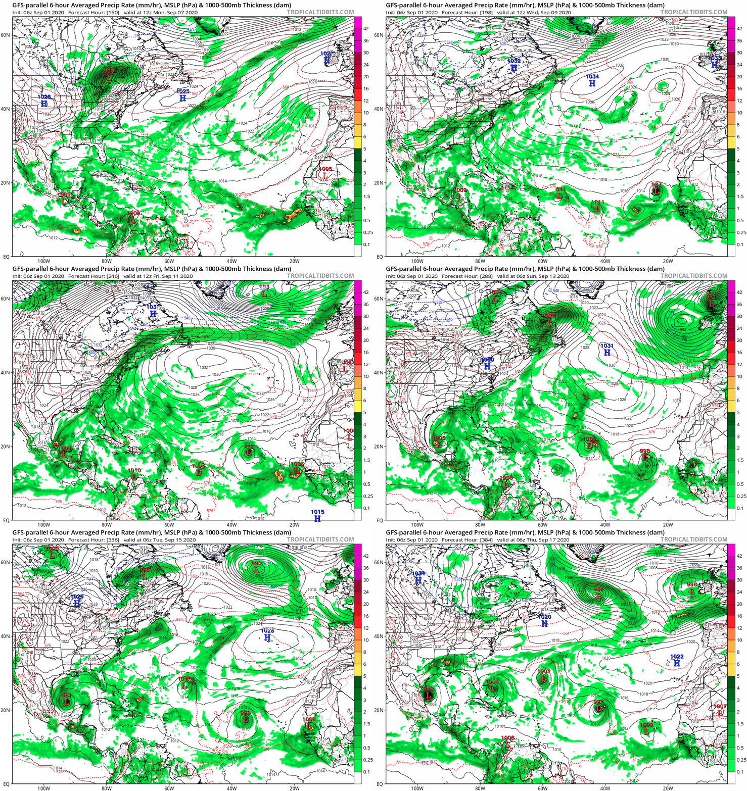
The 6Z GFS Parallel has us on the V storm by September 17th :double:
0 likes   

User avatar
SFLcane
S2K Supporter
S2K Supporter
Posts: 10163
Age: 47
Joined: Sat Jun 05, 2010 1:44 pm
Location: Lake Worth Florida

Re: 2020 Global Model Runs Discussion (Out thru day 16)

#1815 Postby SFLcane » Tue Sep 01, 2020 11:45 am

2 likes   

User avatar
tiger_deF
Category 1
Category 1
Posts: 468
Age: 24
Joined: Tue Sep 27, 2016 11:47 am

Re: 2020 Global Model Runs Discussion (Out thru day 16)

#1816 Postby tiger_deF » Tue Sep 01, 2020 11:49 am

At this point I wouldn't be suprised if we were into the greeks by early October, maybe even earlier
0 likes   

User avatar
SFLcane
S2K Supporter
S2K Supporter
Posts: 10163
Age: 47
Joined: Sat Jun 05, 2010 1:44 pm
Location: Lake Worth Florida

Re: 2020 Global Model Runs Discussion (Out thru day 16)

#1817 Postby SFLcane » Tue Sep 01, 2020 11:59 am

HurricaneFrances04 wrote:The 6Z GFS Parallel has us on the V storm by September 17th :double:


Image
5 likes   

User avatar
KWT
Category 5
Category 5
Posts: 31415
Joined: Tue Aug 17, 2004 11:02 am
Location: UK!!!

Re: 2020 Global Model Runs Discussion (Out thru day 16)

#1818 Postby KWT » Tue Sep 01, 2020 12:00 pm

Starting to look more active on the models.

With that being said the models have been utter garbage at genesis. It's close to the position of just assuming the opposite to what the models believe.

How anyone can defend their performance this season is beyond me...
0 likes   
Personal Forecast Disclaimer:
The posts in this forum are NOT official forecast and should not be used as such. They are just the opinion of the poster and may or may not be backed by sound meteorological data. They are NOT endorsed by any professional institution or storm2k.org. For official information, please refer to the NHC and NWS products

User avatar
SFLcane
S2K Supporter
S2K Supporter
Posts: 10163
Age: 47
Joined: Sat Jun 05, 2010 1:44 pm
Location: Lake Worth Florida

Re: 2020 Global Model Runs Discussion (Out thru day 16)

#1819 Postby SFLcane » Tue Sep 01, 2020 12:08 pm

Small storm but not a good job at all by the European ensembles. :roll:

Not a good year..

 https://twitter.com/jacksillin/status/1300833654034386949


0 likes   

User avatar
Spacecoast
Category 2
Category 2
Posts: 758
Joined: Thu Aug 31, 2017 2:03 pm

Re: 2020 Global Model Runs Discussion (Out thru day 16)

#1820 Postby Spacecoast » Tue Sep 01, 2020 12:16 pm

12z genesis 7 day consensus up to 82% with CMC/GFS/UK on board
Image
0 likes   


Return to “Talkin' Tropics”

Who is online

Users browsing this forum: duilaslol and 24 guests