12z Euro shows this system interacting with 91L at around 72 hours, beginning to merge by 96 hours.
Models generally have low skill in predicting how these interactions will work, on top of how poor they've been with TC genesis this season.
Tropical Wave off the African Coast (Is Invest 92L)
Moderator: S2k Moderators
Forum rules

The posts in this forum are NOT official forecasts and should not be used as such. They are just the opinion of the poster and may or may not be backed by sound meteorological data. They are NOT endorsed by any professional institution or STORM2K. For official information, please refer to products from the National Hurricane Center and National Weather Service.
-
Hypercane_Kyle

- Category 5

- Posts: 3465
- Joined: Sat Mar 07, 2015 7:58 pm
- Location: Cape Canaveral, FL
Re: Tropical Wave off the African Coast
0 likes
My posts are my own personal opinion, defer to the National Hurricane Center (NHC) and other NOAA products for decision making during hurricane season.
-
Hypercane_Kyle
- Category 5
- Posts: 3465
- Joined: Sat Mar 07, 2015 7:58 pm
- Location: Cape Canaveral, FL
Re: Tropical Wave off the African Coast
12z ECMWF has a strong tropical storm/hurricane by 192 hours.
0 likes
My posts are my own personal opinion, defer to the National Hurricane Center (NHC) and other NOAA products for decision making during hurricane season.
-
ColdMiser123

- Professional-Met

- Posts: 905
- Age: 29
- Joined: Mon Sep 26, 2016 3:26 pm
- Location: Northeast US
Re: Tropical Wave off the African Coast
Pretty skeptical of that progression in the north Atlantic on the 12z ECMWF. EPS have a very strong signal for a ridge where the 12z ECMWF has a strong trough over Newfoundland. Makes a lot of difference in steering.
2 likes
B.S., M.S., Meteorology & Atmospheric Science
-
SFLcane

- S2K Supporter

- Posts: 10281
- Age: 48
- Joined: Sat Jun 05, 2010 1:44 pm
- Location: Lake Worth Florida
Re: Tropical Wave off the African Coast
Trap door opens up on the 12z euro. Wondering if this why the eps is so persistent recurving this near 60w.
Highly Complicated out there...
Highly Complicated out there...
0 likes
Re: Tropical Wave off the African Coast
SFLcane wrote:Well this is interesting...
https://i.postimg.cc/Znr64gBq/89893-E03-364-B-4104-AA44-858-E4-B652928.gif
Dorians twin lol
0 likes
-
TheProfessor

- Professional-Met
- Posts: 3506
- Age: 29
- Joined: Tue Dec 03, 2013 10:56 am
- Location: Wichita, Kansas
Re: Tropical Wave off the African Coast
SFLcane wrote:Trap door opens up on the 12z euro. Wondering if this why the eps is so persistent recurving this near 60w.
Highly Complicated out there...
Trap door is there for a bit, but the ridge is shifting back east at the end of run and the storm could get trapped underneath it in the case the ridge continued to move east.
0 likes
An alumnus of The Ohio State University.
Your local National Weather Service office is your best source for weather information.
Your local National Weather Service office is your best source for weather information.
-
ColdMiser123
- Professional-Met
- Posts: 905
- Age: 29
- Joined: Mon Sep 26, 2016 3:26 pm
- Location: Northeast US
Re: Tropical Wave off the African Coast
Very complicated pattern verbatim, I suspect we will see EPS members all the way to the southeast US coast and members recurve east of Bermuda given the complicated progression with the mid-level trough moving westward, and how exactly it erodes the ridge to the north.
7 likes
B.S., M.S., Meteorology & Atmospheric Science
-
SFLcane
- S2K Supporter
- Posts: 10281
- Age: 48
- Joined: Sat Jun 05, 2010 1:44 pm
- Location: Lake Worth Florida
Re: Tropical Wave off the African Coast
TheProfessor wrote:SFLcane wrote:Trap door opens up on the 12z euro. Wondering if this why the eps is so persistent recurving this near 60w.
Highly Complicated out there...
Trap door is there for a bit, but the ridge is shifting back east at the end of run and the storm could get trapped underneath it in the case the ridge continued to move east.
You'd expect to see a pretty big ensemble signal for that possibility. It is a rather larger trap door.
0 likes
-
DestinHurricane

- Category 4

- Posts: 935
- Joined: Tue May 01, 2018 8:05 am
- Location: New York, NY
Re: Tropical Wave off the African Coast
SFLcane wrote:TheProfessor wrote:SFLcane wrote:Trap door opens up on the 12z euro. Wondering if this why the eps is so persistent recurving this near 60w.
Highly Complicated out there...
Trap door is there for a bit, but the ridge is shifting back east at the end of run and the storm could get trapped underneath it in the case the ridge continued to move east.
You'd expect to see a pretty big ensemble signal for that possibility. It is a rather larger trap door.
This setup kind of reminds me of Florence.
1 likes
Michael 2018
Re: Tropical Wave off the African Coast
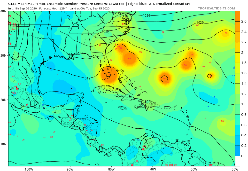
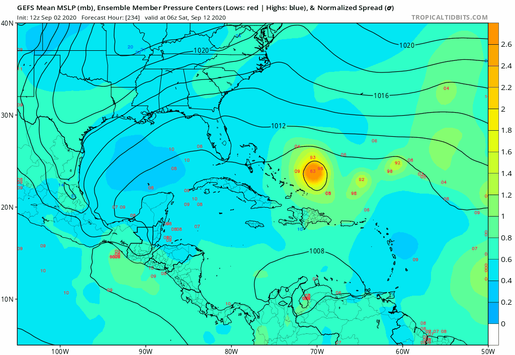
As ominous as is the 12Z GEFS for the Bahamas and SE US with a whopping 33% of members hitting with a H midmonth, the 12Z EPS has only one member (2%) that ever gets close to either with it in the Bahamas at hour 312 (9/15) followed by a move W into S FL. The ones well E recurve way OTS and the 2 in the GOM are not from this though I think this is severely underdoing the threat and will likely later correct for it:

As already mentioned here and to show the drastric contrast, the 12Z GEFS suggests the opposite with 33% hitting the SE US, but it of course may be overdoing the threat:

I should add that the aforementioned 12Z Para GEFS is in between these two threat-wise with some SE hits but with many recurving OTS due to a much further E WAR vs the 12Z GEFS. Also, the 12Z GEPS says recurve well OTS for the same reason.
As already mentioned here and to show the drastric contrast, the 12Z GEFS suggests the opposite with 33% hitting the SE US, but it of course may be overdoing the threat:
I should add that the aforementioned 12Z Para GEFS is in between these two threat-wise with some SE hits but with many recurving OTS due to a much further E WAR vs the 12Z GEFS. Also, the 12Z GEPS says recurve well OTS for the same reason.
2 likes
Personal Forecast Disclaimer:
The posts in this forum are NOT official forecasts and should not be used as such. They are just the opinion of the poster and may or may not be backed by sound meteorological data. They are NOT endorsed by any professional institution or storm2k.org. For official information, please refer to the NHC and NWS products.
The posts in this forum are NOT official forecasts and should not be used as such. They are just the opinion of the poster and may or may not be backed by sound meteorological data. They are NOT endorsed by any professional institution or storm2k.org. For official information, please refer to the NHC and NWS products.

-
Spacecoast

- Category 2

- Posts: 773
- Joined: Thu Aug 31, 2017 2:03 pm
Re: Tropical Wave off the African Coast
ECMF Wind field tracks trend:
09/01 00z

09/02 00z

09/02 12z

Track Density trend
09/02 00z

09/02 12z

09/01 00z
09/02 00z
09/02 12z
Track Density trend
09/02 00z
09/02 12z
1 likes
-
storminabox
- Category 1

- Posts: 263
- Joined: Sun Jul 09, 2017 10:50 pm
Re: Tropical Wave off the African Coast
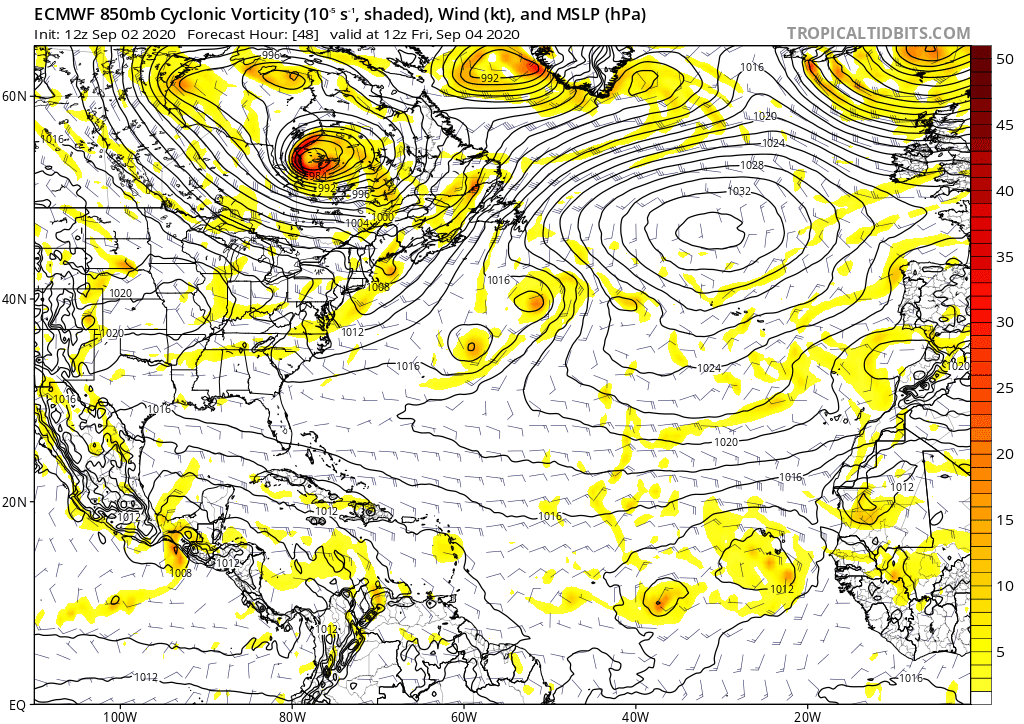
gatorcane wrote:Could be a big ACE pumper if the Euro is correct:
https://i.postimg.cc/4xpPHhF3/ecmwf-uv850-vort-atl-fh48-240-2.gif
We’re due for a big ACE pumper. Those are my favorites.
0 likes
-
cycloneye

- Admin

- Posts: 149719
- Age: 69
- Joined: Thu Oct 10, 2002 10:54 am
- Location: San Juan, Puerto Rico
Re: Tropical Wave off the African Coast
A tropical wave, located just off the coast of west Africa, is
producing disorganized shower and thunderstorm activity. The wave
is expected to merge with a disturbance centered a couple of hundred
miles southeast of the Cabo Verde Islands toward the end of the
week. Gradual development of this system is then possible, and a
tropical depression could form over the weekend or early next week
while it moves westward over the eastern and central tropical
Atlantic Ocean.
* Formation chance through 48 hours...low...20 percent.
* Formation chance through 5 days...medium...60 percent.
0 likes
Visit the Caribbean-Central America Weather Thread where you can find at first post web cams,radars
and observations from Caribbean basin members Click Here
and observations from Caribbean basin members Click Here
Re: Tropical Wave off the African Coast
storminabox wrote:gatorcane wrote:Could be a big ACE pumper if the Euro is correct:
https://i.postimg.cc/4xpPHhF3/ecmwf-uv850-vort-atl-fh48-240-2.gif
We’re due for a big ACE pumper. Those are my favorites.
I prefer the ones that don't pump around land, which seems to be a hard thing to do in the Atlantic these days...but yeah, I'd like to see a fish C4 or something out in the middle of the Atlantic. If this is going to be our second season with Greek letter storms, I feel like it has to involve at least one long-lived major.
2 likes
-
Hurricaneman

- Category 5
- Posts: 7404
- Age: 45
- Joined: Tue Aug 31, 2004 3:24 pm
- Location: central florida
Re: Tropical Wave off the African Coast
storminabox wrote:gatorcane wrote:Could be a big ACE pumper if the Euro is correct:
https://i.postimg.cc/4xpPHhF3/ecmwf-uv850-vort-atl-fh48-240-2.gif
We’re due for a big ACE pumper. Those are my favorites.
If the 18zGFS is even close to correct on track it could be a big ace pumper but also a big US threat, have to see what the trends in the models is, the GFS seems to build the ridge back in having the trough in the eastern GOM causing a Florida run this run
0 likes

Re: Tropical Wave off the African Coast
us89 wrote:storminabox wrote:gatorcane wrote:Could be a big ACE pumper if the Euro is correct:
https://i.postimg.cc/4xpPHhF3/ecmwf-uv850-vort-atl-fh48-240-2.gif
We’re due for a big ACE pumper. Those are my favorites.
I prefer the ones that don't pump around land, which seems to be a hard thing to do in the Atlantic these days...but yeah, I'd like to see a fish C4 or something out in the middle of the Atlantic. If this is going to be our second season with Greek letter storms, I feel like it has to involve at least one long-lived major.
The best case scenario for a big ACE maker is a track like Katia ‘11 and an intensity like Lorenzo ‘19 — a big high end Cat 4 prowling the open Atlantic, without hitting any islands or random ships. With all of the waves forecast to come off Africa and attempt to develop according to the models, at least one of them is bound to be a high ACE long-tracking major.
1 likes
Irene '11 Sandy '12 Hermine '16 5/15/2018 Derecho Fay '20 Isaias '20 Elsa '21 Henri '21 Ida '21
I am only a meteorology enthusiast who knows a decent amount about tropical cyclones. Look to the professional mets, the NHC, or your local weather office for the best information.
I am only a meteorology enthusiast who knows a decent amount about tropical cyclones. Look to the professional mets, the NHC, or your local weather office for the best information.
-
Shell Mound
- Category 5
- Posts: 2432
- Age: 33
- Joined: Thu Sep 07, 2017 3:39 pm
- Location: St. Petersburg, FL → Scandinavia
Re: Tropical Wave off the African Coast
This wave will probably turn OTS if it strengthens early on, due to its interaction with the strong TUTT nearby, which weakens the southern flank of the ridge.
1 likes
CVW / MiamiensisWx / Shell Mound
The posts in this forum are NOT official forecasts and should not be used as such. They are just the opinion of the poster and may or may not be backed by sound meteorological data. They are NOT endorsed by any professional institution or STORM2K. For official information, please refer to products from the NHC and NWS.

Who is online
Users browsing this forum: No registered users and 133 guests