
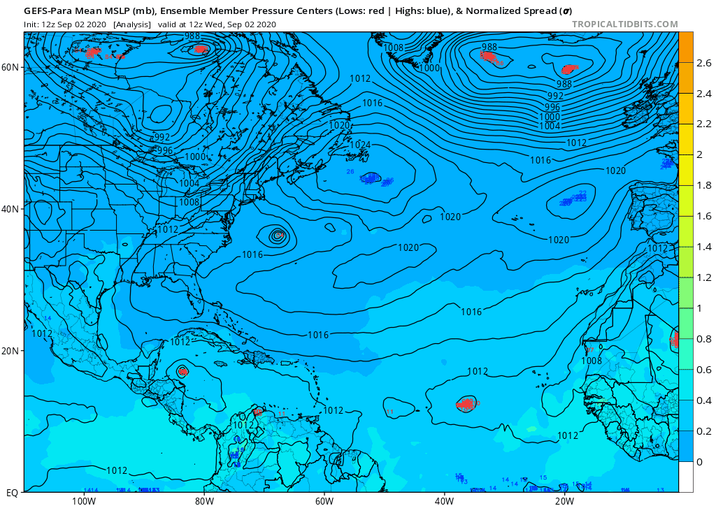
GEFS & GEFS-Para both say not so fast Mr. GFS Operational of shutting off the GOM, they show possible threats to the US on their 7-15 day range.
GEFS-Para more so than the GEFS.
2020 Global Model Runs Discussion (Out thru day 16)
Moderator: S2k Moderators
Forum rules

The posts in this forum are NOT official forecasts and should not be used as such. They are just the opinion of the poster and may or may not be backed by sound meteorological data. They are NOT endorsed by any professional institution or STORM2K. For official information, please refer to products from the National Hurricane Center and National Weather Service.
Re: 2020 Global Model Runs Discussion (Out thru day 16)
Models showing that the waves exiting Africa the next several days have decent chance of development, but bring them to screeching halts over the central atlantic - very strange for early Sept?
0 likes
-
'CaneFreak

- Category 5

- Posts: 1487
- Joined: Mon Jun 05, 2006 10:50 am
- Location: New Bern, NC
Re: 2020 Global Model Runs Discussion (Out thru day 16)
TheProfessor wrote:As always I would advise using the ensemble forecasts instead of day to day deterministic runs. Knowing biases as well will also help deciphering models. Anyways I think we're going to continue to see storms struggle in the MDR if that mid-level low forms. That low will also keep storms from recurving if they don't take an early exit when they leave Africa, which is an additional concern. As for biases we know that the GFS tends to overdue troughs and is usually the more progressive models. Meanwhile the Euro tends to overdue ridges and will sometimes favor blocking a bit too much. In all likelihood we'll see something in between, which suggests possible Florida EC and U.S EC threats when storms are approaching from the east. Storms in the Caribbean would be pulled into the Gulf like Charley, Ivan, Marco, etc. However, since this pattern is dependent on two tropical cyclones, we'll need to wait and see what they do, the further wester they recurve, the further west we'll likely see the trough setup and the more likely we'll see a cutoff low develop, which would open the whole GoM up for waves coming off of Africa.
To put it plainly I don't like the look of this pattern with combination of the wave train that the models are starting to show. As stated above, any storm that doesn't take an early exit to the north, assuming that mid-level trough does form in the Atlantic, will likely be stored towards the U.S without an exit route until the storm either gets too close to comfort, or landfalls. Then there's both the GEFS and GEPS showing a large upper level anticyclone developing off the African coast for waves to travel right into to help keep them organized. Depending on how much wind shear we see, we could have a case where waves have well developed MLCs, but LLCs struggle due to shear until the storms get further west where they can then go off under better conditions.
Sir I'm going to bump this post because I agree and share your same concerns. If you look at many of the ensemble forecasts for days 8-10 including the GEFS, GEFS-Para, GEPS, you will see a similar pattern. Trough in the OH Valley & Great Lakes with a ridge over the Northwest Atlantic into Newfoundland. That's a scary pattern folks. Let's hope that the Central Atlantic trough shown on some of the Ensemble forecasts holds and we can get storms to turn out to sea. Otherwise, it's going to be a long month because all models show the African Wave train rolling this month.


5 likes
-
gatorcane

- S2K Supporter

- Posts: 23708
- Age: 48
- Joined: Sun Mar 13, 2005 3:54 pm
- Location: Boca Raton, FL
Re: 2020 Global Model Runs Discussion (Out thru day 16)
12Z parallel GFS shows widespread activity out over the open Atlantic mostly recurving:
3 likes
-
SFLcane

- S2K Supporter
- Posts: 10281
- Age: 48
- Joined: Sat Jun 05, 2010 1:44 pm
- Location: Lake Worth Florida
Re: 2020 Global Model Runs Discussion (Out thru day 16)
Recurve parade this afternoon on most of the models.
0 likes
-
CyclonicFury

- Category 5
- Posts: 2035
- Age: 27
- Joined: Sun Jul 02, 2017 12:32 pm
- Location: NC
- Contact:
Re: 2020 Global Model Runs Discussion (Out thru day 16)
SFLcane wrote:Recurve parade this afternoon on most of the models.
Hope it stays that way - I'd love a nice recurving Cabo Verde hurricane to track that doesn't affect anyone!
3 likes
NCSU B.S. in Meteorology Class of 2021. Tropical weather blogger at http://www.cyclonicfury.com. My forecasts and thoughts are NOT official, for official forecasts please consult the National Hurricane Center.

Re: 2020 Global Model Runs Discussion (Out thru day 16)
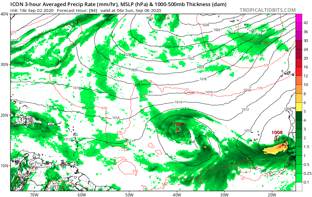
12z GFS-Para run has a long, exciting future for one of the currently active eastern Atlantic waves (it's difficult to tell which one) past 200 hrs.
120 hrs

180 hrs

216 hrs

270 hrs

360 hrs

You can also see the Gulf system it and the CFS have been showing for mid-September in the final image.
120 hrs
180 hrs
216 hrs
270 hrs
360 hrs
You can also see the Gulf system it and the CFS have been showing for mid-September in the final image.
0 likes
Irene '11 Sandy '12 Hermine '16 5/15/2018 Derecho Fay '20 Isaias '20 Elsa '21 Henri '21 Ida '21
I am only a meteorology enthusiast who knows a decent amount about tropical cyclones. Look to the professional mets, the NHC, or your local weather office for the best information.
I am only a meteorology enthusiast who knows a decent amount about tropical cyclones. Look to the professional mets, the NHC, or your local weather office for the best information.
-
'CaneFreak
- Category 5
- Posts: 1487
- Joined: Mon Jun 05, 2006 10:50 am
- Location: New Bern, NC
Re: 2020 Global Model Runs Discussion (Out thru day 16)
Now that I can believe based on the upcoming pattern.  It's going to be an interesting month.
0 likes
-
Hypercane_Kyle

- Category 5
- Posts: 3465
- Joined: Sat Mar 07, 2015 7:58 pm
- Location: Cape Canaveral, FL
Re: 2020 Global Model Runs Discussion (Out thru day 16)
0 likes
My posts are my own personal opinion, defer to the National Hurricane Center (NHC) and other NOAA products for decision making during hurricane season.
-
emeraldislenc
- Category 2

- Posts: 601
- Joined: Fri Aug 24, 2012 4:49 pm
- Location: Emerald Isle NC
Re: 2020 Global Model Runs Discussion (Out thru day 16)
I keep getting mixed signals from different people here on this site. Guess we will just have to wait and see
13 likes
-
DestinHurricane

- Category 4

- Posts: 935
- Joined: Tue May 01, 2018 8:05 am
- Location: New York, NY
Re: 2020 Global Model Runs Discussion (Out thru day 16)
18Z GFS brings a weak TS to FL straights irma track but goes poof.
0 likes
Michael 2018
-
toad strangler

- S2K Supporter
- Posts: 4546
- Joined: Sun Jul 28, 2013 3:09 pm
- Location: Earth
- Contact:
Re: 2020 Global Model Runs Discussion (Out thru day 16)
emeraldislenc wrote:I keep getting mixed signals from different people here on this site. Guess we will just have to wait and see
Welcome to S2K
But in all fairness, it's hard to put much weight in modeling this year. No One saw this coming.
1 likes
My Weather Station
https://www.wunderground.com/dashboard/pws/KFLPORTS603
https://www.wunderground.com/dashboard/pws/KFLPORTS603
Re: 2020 Global Model Runs Discussion (Out thru day 16)
Noteworthy in that this run has the lead system quite a bit SW at 120hrs than the 12z run. Looking to see if the model solutions of a very slow/stall motion will verify
0 likes
-
floridasun78
- Category 5
- Posts: 3755
- Joined: Sun May 17, 2009 10:16 pm
- Location: miami fl
-
gatorcane
- S2K Supporter
- Posts: 23708
- Age: 48
- Joined: Sun Mar 13, 2005 3:54 pm
- Location: Boca Raton, FL
Re: 2020 Global Model Runs Discussion (Out thru day 16)
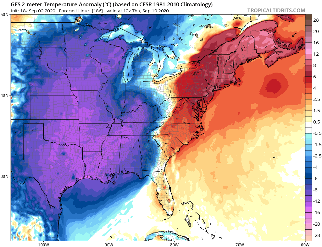
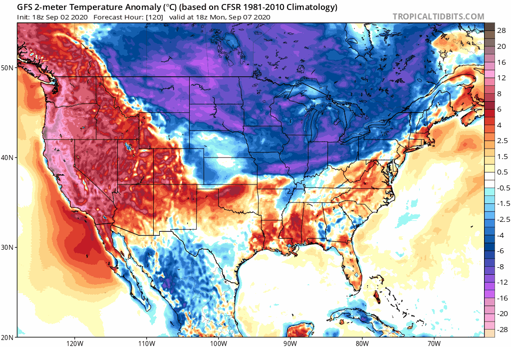
Speaking of the GFS, it insists some chilly air for early-mid September will penetrate all the way down into the northern Gulf:
1 likes
-
Spacecoast

- Category 2
- Posts: 773
- Joined: Thu Aug 31, 2017 2:03 pm
Re: 2020 Global Model Runs Discussion (Out thru day 16)
CyclonicFury wrote:It depends on what you are referring to. I'd imagine you are talking about CV threats from the U.S., which does often wind down after mid-September. However, in a -ENSO year like 2020, the Caribbean region will need to be watched in October for a potential threat. Florida landfalls in October remain common.
Besides...this has not been a quiet season for U.S. threats at all. We've seen seven named storms, three hurricanes and one major hurricane make landfall in the US alone. While Florida has been spared so far, the rest of the basin hasn't been lucky.
As for the season as a whole, it's September 2, not November 2. We haven't even hit the climatological peak yet (which is in 8 days).
My guess is that we will get 4-10 more named storms, 3-7 more Hurricanes, and 2-5 more Major Hurricanes.
I am 70% confident of that prediction, because it is NOAA's forecast, and their stated C.I.
If I wanted to be 90% confident, I could also predict something like: 1-15 more named storms, 0-15 more Hurricanes,
and 0-10 more Major Hurricanes. But that prediction (although more likely) is so vague, it would be useless.
I guess that is why NOAA, et al use the 70% statistical confidence interval, rather than the 90-95% C.I, used in other disciplines.
0 likes
-
crownweather

- S2K Supporter
- Posts: 602
- Age: 51
- Joined: Sat Aug 12, 2006 9:21 am
- Location: Sturbridge, Massachusetts
- Contact:
Re: 2020 Global Model Runs Discussion (Out thru day 16)
gatorcane wrote:Speaking of the GFS, it insists some chilly air for early-mid September will penetrate all the way down into the northern Gulf:
https://i.postimg.cc/Hsv2vZzc/gfs-T2ma-eus-32.png
If the GFS model is right and we do see that big of a chill into the northern Gulf of Mexico, I will donate $50 to Storm2K.
17 likes
Rob Lightbown
Crown Weather Services
https://crownweather.com
Crown Weather Services
https://crownweather.com
Re: 2020 Global Model Runs Discussion (Out thru day 16)
crownweather wrote:gatorcane wrote:Speaking of the GFS, it insists some chilly air for early-mid September will penetrate all the way down into the northern Gulf:
https://i.postimg.cc/Hsv2vZzc/gfs-T2ma-eus-32.png
If the GFS model is right and we do see that big of a chill into the northern Gulf of Mexico, I will donate $50 to Storm2K.
Yeah let's see what happens. GFS predicts low of 48 in New Orleans on Sep 10. Record low for date is 62.
2 likes
-
gatorcane
- S2K Supporter
- Posts: 23708
- Age: 48
- Joined: Sun Mar 13, 2005 3:54 pm
- Location: Boca Raton, FL
Re: 2020 Global Model Runs Discussion (Out thru day 16)
It’s not just how cool the GFS gets but look how long the GFS keeps the cooler anomalies around for, nearly a week!  SSTs would take a serious hit if this happens:
SSTs would take a serious hit if this happens:
Last edited by gatorcane on Wed Sep 02, 2020 8:35 pm, edited 2 times in total.
2 likes
Who is online
Users browsing this forum: Ulf and 307 guests