2020 Global Model Runs Discussion (Out thru day 16)

This is the general tropical discussion area. Anyone can take their shot at predicting a storms path.

Moderator: S2k Moderators

Forum rules

The posts in this forum are NOT official forecasts and should not be used as such. They are just the opinion of the poster and may or may not be backed by sound meteorological data. They are NOT endorsed by any professional institution or STORM2K. For official information, please refer to products from the National Hurricane Center and National Weather Service.

Help Support Storm2K
Message
Author
ClarCari
Category 2
Category 2
Posts: 579
Joined: Thu Aug 13, 2020 11:02 am

Re: 2020 Global Model Runs Discussion (Out thru day 16)

#1901 Postby ClarCari » Wed Sep 02, 2020 8:34 pm

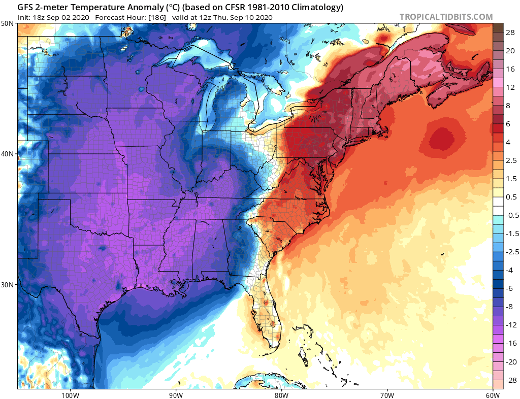
gatorcane wrote:It’s not just how cool the GFS gets but looks how long the GFS keeps the cooler anomalies around for, nearly a week! :double: SSTs would take a serious hit if this happens:
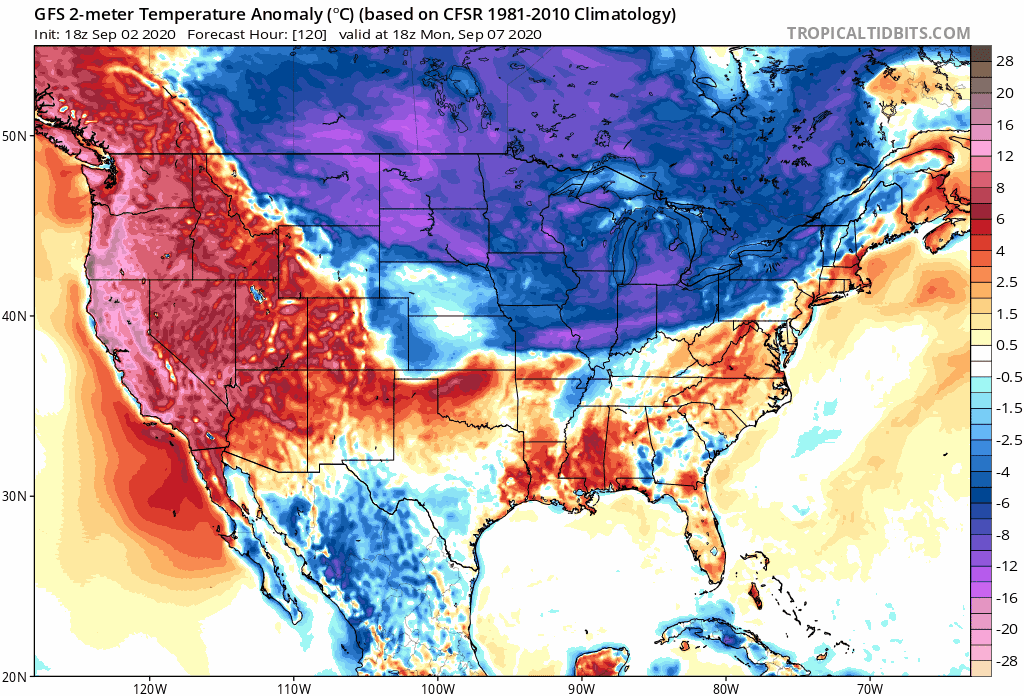
Image
sma10 wrote:
crownweather wrote:
gatorcane wrote:Speaking of the GFS, it insists some chilly air for early-mid September will penetrate all the way down into the northern Gulf:

https://i.postimg.cc/Hsv2vZzc/gfs-T2ma-eus-32.png


If the GFS model is right and we do see that big of a chill into the northern Gulf of Mexico, I will donate $50 to Storm2K.


Yeah let's see what happens. GFS predicts low of 48 in New Orleans on Sep 10. Record low for date is 62.


All the more reason to believe this WON’T happen. At least not anywhere near close to the GFS predictions :sun:

A week of a nice chill break and some scattered storms would be a little nice tho!
2 likes   

User avatar
toad strangler
S2K Supporter
S2K Supporter
Posts: 4543
Joined: Sun Jul 28, 2013 3:09 pm
Location: Earth
Contact:

Re: 2020 Global Model Runs Discussion (Out thru day 16)

#1902 Postby toad strangler » Wed Sep 02, 2020 9:28 pm

Watching the Euro and GFS the past week has me a little concerned that the end game for points west end like this ..

https://www.youtube.com/watch?v=-JPL-rEuc9o
2 likes   

User avatar
eastcoastFL
Category 5
Category 5
Posts: 3901
Age: 43
Joined: Thu Apr 12, 2007 12:29 pm
Location: Palm City, FL

Re: 2020 Global Model Runs Discussion (Out thru day 16)

#1903 Postby eastcoastFL » Wed Sep 02, 2020 10:07 pm

18z GFS-Para


Image
1 likes   
Personal Forecast Disclaimer:
The posts in this forum are NOT official forecast and should not be used as such. They are just the opinion of the poster and may or may not be backed by sound meteorological data. They are NOT endorsed by any professional institution or storm2k.org. For official information, please refer to the NHC and NWS products.

User avatar
eastcoastFL
Category 5
Category 5
Posts: 3901
Age: 43
Joined: Thu Apr 12, 2007 12:29 pm
Location: Palm City, FL

Re: 2020 Global Model Runs Discussion (Out thru day 16)

#1904 Postby eastcoastFL » Wed Sep 02, 2020 10:10 pm

18z GEFS

Image
1 likes   
Personal Forecast Disclaimer:
The posts in this forum are NOT official forecast and should not be used as such. They are just the opinion of the poster and may or may not be backed by sound meteorological data. They are NOT endorsed by any professional institution or storm2k.org. For official information, please refer to the NHC and NWS products.

User avatar
NDG
S2K Supporter
S2K Supporter
Posts: 15446
Joined: Sun Jul 09, 2006 10:14 pm
Location: Orlando, FL

Re: 2020 Global Model Runs Discussion (Out thru day 16)

#1905 Postby NDG » Wed Sep 02, 2020 10:14 pm

The area to watch will be the GOM next week if the 12z Euro/EPS and 12z CMC/GEPS are correct. Even some of the GEFS-Para members show possible development by the middle to late next week. If the GFS proves to be correct, then forget about it.
0 likes   

User avatar
NDG
S2K Supporter
S2K Supporter
Posts: 15446
Joined: Sun Jul 09, 2006 10:14 pm
Location: Orlando, FL

Re: 2020 Global Model Runs Discussion (Out thru day 16)

#1906 Postby NDG » Wed Sep 02, 2020 10:25 pm

0z Icon is also liking the idea of possible development in the NW Caribbean-Eastern GOM next week.

Image
0 likes   

User avatar
NDG
S2K Supporter
S2K Supporter
Posts: 15446
Joined: Sun Jul 09, 2006 10:14 pm
Location: Orlando, FL

Re: 2020 Global Model Runs Discussion (Out thru day 16)

#1907 Postby NDG » Wed Sep 02, 2020 11:13 pm

GFS little by little is trending towards the Euro, but still big differences.
0z Icon is very similar to the Euro.
0 likes   

sma10
Category 5
Category 5
Posts: 1710
Joined: Tue Aug 02, 2005 1:13 pm

Re: 2020 Global Model Runs Discussion (Out thru day 16)

#1908 Postby sma10 » Wed Sep 02, 2020 11:42 pm

NDG wrote:GFS little by little is trending towards the Euro, but still big differences.
0z Icon is very similar to the Euro.


CMC also trending big to the west, and UK as well. Still tons of uncertainty in long range, in terms of eventual turning
0 likes   

User avatar
Hypercane_Kyle
Category 5
Category 5
Posts: 3354
Joined: Sat Mar 07, 2015 7:58 pm
Location: Cape Canaveral, FL

Re: 2020 Global Model Runs Discussion (Out thru day 16)

#1909 Postby Hypercane_Kyle » Thu Sep 03, 2020 12:26 am

Models have also been strongly hinting at something spinning up in the BoC at the tail end of that cold front that brings temperatures in the 50s all the way to the Gulf Coast.
1 likes   
My posts are my own personal opinion, defer to the National Hurricane Center (NHC) and other NOAA products for decision making during hurricane season.

User avatar
Kingarabian
S2K Supporter
S2K Supporter
Posts: 15987
Joined: Sat Aug 08, 2009 3:06 am
Location: Honolulu, Hawaii

Re: 2020 Global Model Runs Discussion (Out thru day 16)

#1910 Postby Kingarabian » Thu Sep 03, 2020 2:32 am

00z Euro continues to lighten it up.
Image
2 likes   
RIP Kobe Bryant

hurricaneCW
Category 5
Category 5
Posts: 1794
Joined: Wed Mar 03, 2010 6:20 am
Location: Toms River, NJ

Re: 2020 Global Model Runs Discussion (Out thru day 16)

#1911 Postby hurricaneCW » Thu Sep 03, 2020 4:19 am

Kingarabian wrote:00z Euro continues to lighten it up.
https://i.imgur.com/BdTEv8I.png


Big yikes there. GFS has a strong hurricane there that recurves near Bermuda but the GFS is likely underdoing the ridging.

Under the Euro setup both systems could head west and impact the US east coast.
0 likes   

User avatar
NDG
S2K Supporter
S2K Supporter
Posts: 15446
Joined: Sun Jul 09, 2006 10:14 pm
Location: Orlando, FL

Re: 2020 Global Model Runs Discussion (Out thru day 16)

#1912 Postby NDG » Thu Sep 03, 2020 5:45 am

Like I said before going to bed last night that the GFS was little by little trending towards the Euro, nobody who bet against the GFS is loosing their house.

Image
1 likes   

User avatar
Ivanhater
Storm2k Moderator
Storm2k Moderator
Posts: 11162
Age: 38
Joined: Fri Jul 01, 2005 8:25 am
Location: Pensacola

Re: 2020 Global Model Runs Discussion (Out thru day 16)

#1913 Postby Ivanhater » Thu Sep 03, 2020 5:52 am

NDG wrote:Like I said before going to bed last night that the GFS was little by little trending towards the Euro, nobody who bet against the GFS is loosing their house.

https://i.imgur.com/OmkIXon.gif


Great post. Anyone who thought record low 40s were coming to the Gulf coast in early September were wishful thinking.
4 likes   
Michael

User avatar
SFLcane
S2K Supporter
S2K Supporter
Posts: 10163
Age: 47
Joined: Sat Jun 05, 2010 1:44 pm
Location: Lake Worth Florida

Re: 2020 Global Model Runs Discussion (Out thru day 16)

#1914 Postby SFLcane » Thu Sep 03, 2020 5:57 am

NDG wrote:Like I said before going to bed last night that the GFS was little by little trending towards the Euro, nobody who bet against the GFS is loosing their house.

https://i.imgur.com/OmkIXon.gif


Still no sign of a TC getting under that ridge though.
1 likes   

User avatar
SFLcane
S2K Supporter
S2K Supporter
Posts: 10163
Age: 47
Joined: Sat Jun 05, 2010 1:44 pm
Location: Lake Worth Florida

Re: 2020 Global Model Runs Discussion (Out thru day 16)

#1915 Postby SFLcane » Thu Sep 03, 2020 6:01 am

Should finally get us some ACE at least.
0 likes   

otowntiger
Category 5
Category 5
Posts: 1921
Joined: Tue Aug 31, 2004 7:06 pm

Re: 2020 Global Model Runs Discussion (Out thru day 16)

#1916 Postby otowntiger » Thu Sep 03, 2020 6:58 am

sma10 wrote:
crownweather wrote:
gatorcane wrote:Speaking of the GFS, it insists some chilly air for early-mid September will penetrate all the way down into the northern Gulf:

https://i.postimg.cc/Hsv2vZzc/gfs-T2ma-eus-32.png


If the GFS model is right and we do see that big of a chill into the northern Gulf of Mexico, I will donate $50 to Storm2K.


Yeah let's see what happens. GFS predicts low of 48 in New Orleans on Sep 10. Record low for date is 62.

It’s clear the GFS is overdoing this cold front, just a bit. Would be nice, but there is no way that NOLA breaks an overnight record low by 14, degrees. Lol!
1 likes   

User avatar
chaser1
S2K Supporter
S2K Supporter
Posts: 5475
Age: 64
Joined: Sat Oct 15, 2005 5:59 pm
Location: Longwood, Fl

Re: 2020 Global Model Runs Discussion (Out thru day 16)

#1917 Postby chaser1 » Thu Sep 03, 2020 7:06 am

toad strangler wrote:Watching the Euro and GFS the past week has me a little concerned that the end game for points west end like this ..

https://www.youtube.com/watch?v=-JPL-rEuc9o


Loved that lol. I'm gonna call this my cinematic interpretation :wink: Based on that short clip, a probable WNW approach to Florida with a sudden WSW dive toward a Ft. Lauderdale landfall (but potentially land-falling a bit north around Vero)
0 likes   
Andy D

(For official information, please refer to the NHC and NWS products.)

User avatar
NDG
S2K Supporter
S2K Supporter
Posts: 15446
Joined: Sun Jul 09, 2006 10:14 pm
Location: Orlando, FL

Re: 2020 Global Model Runs Discussion (Out thru day 16)

#1918 Postby NDG » Thu Sep 03, 2020 7:22 am

SFLcane wrote:
NDG wrote:Like I said before going to bed last night that the GFS was little by little trending towards the Euro, nobody who bet against the GFS is loosing their house.

https://i.imgur.com/OmkIXon.gif


Still no sign of a TC getting under that ridge though.


I would still still watch for possible development in the NW Caribbean/eastern GOM next week, some EPS and GEPS show some weak development possible in this area.
0 likes   

User avatar
northjaxpro
S2K Supporter
S2K Supporter
Posts: 8900
Joined: Mon Sep 27, 2010 11:21 am
Location: Jacksonville, FL

Re: 2020 Global Model Runs Discussion (Out thru day 16)

#1919 Postby northjaxpro » Thu Sep 03, 2020 7:39 am

NDG wrote:Like I said before going to bed last night that the GFS was little by little trending towards the Euro, nobody who bet against the GFS is loosing their house.

https://i.imgur.com/OmkIXon.gif


With a strong + NAO currently ongoing, yeah no way we are seeing a trough of that magnitude coming our way anytime soon.
1 likes   
NEVER, EVER SAY NEVER in the tropics and weather in general, and most importantly, with life itself!!

________________________________________________________________________________________

Fay 2008 Beryl 2012 Debby 2012 Colin 2016 Hermine 2016 Julia 2016 Matthew 2016 Irma 2017 Dorian 2019

SconnieCane
Category 4
Category 4
Posts: 998
Joined: Thu Aug 02, 2018 5:29 pm
Location: Madison, WI

Re: 2020 Global Model Runs Discussion (Out thru day 16)

#1920 Postby SconnieCane » Thu Sep 03, 2020 7:39 am

Kingarabian wrote:00z Euro continues to lighten it up.
https://i.imgur.com/BdTEv8I.png


Looks like a little gap in the "double-barreled" ridge there, but probably not enough to turn that lead TC sharply to the NE.
0 likes   


Return to “Talkin' Tropics”

Who is online

Users browsing this forum: cycloneye, Hurricaneman, Stratton23 and 71 guests