2020 Global Model Runs Discussion (Out thru day 16)
Moderator: S2k Moderators
Forum rules
The posts in this forum are NOT official forecasts and should not be used as such. They are just the opinion of the poster and may or may not be backed by sound meteorological data. They are NOT endorsed by any professional institution or STORM2K. For official information, please refer to products from the National Hurricane Center and National Weather Service.
- toad strangler
- S2K Supporter

- Posts: 4546
- Joined: Sun Jul 28, 2013 3:09 pm
- Location: Earth
- Contact:
Re: 2020 Global Model Runs Discussion (Out thru day 16)
That’s as clear of a signal from the Euro than we have seen all year. Looks like straight forward origin and development minus all of the dancing, stalling, and hocus pocus of recent. Will be interesting at 0z to see if that signal sticks and moves forward.
3 likes
My Weather Station
https://www.wunderground.com/dashboard/pws/KFLPORTS603
https://www.wunderground.com/dashboard/pws/KFLPORTS603
- gatorcane
- S2K Supporter

- Posts: 23708
- Age: 48
- Joined: Sun Mar 13, 2005 3:54 pm
- Location: Boca Raton, FL
Re: 2020 Global Model Runs Discussion (Out thru day 16)
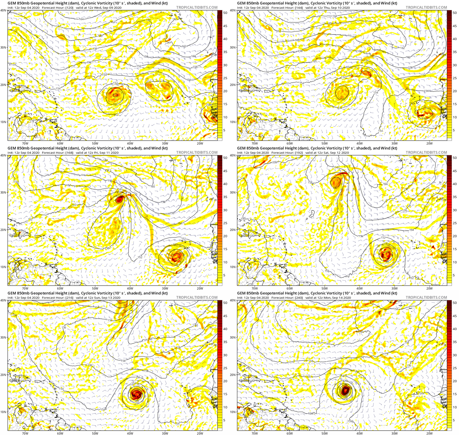
12Z CMC has it too. Animation below. Getting a little late to have something make the journey across to impact the CONUS especially that deep, but will need to watch the islands:

1 likes
- Emmett_Brown
- Category 5

- Posts: 1433
- Joined: Wed Aug 24, 2005 9:10 pm
- Location: Sarasota FL
Re: 2020 Global Model Runs Discussion (Out thru day 16)
Just my opinion, but the model solutions for the eastern Atlantic are still very inconsistent. Models are struggling to figure out the complex interactions of 91, 92, and the 2 waves over Africa. They try to develop several at once, which could mean no development until one of these waves breaks free from the rest, or until they consolidate... a process that usually takes some time. I'm starting to think far east development may be delayed a week or so. Maybe conditions are "too favorable". Don't get me wrong, we'll have development out there before the middle of the month, but maybe not until that mess gets mopped up.
Last edited by Emmett_Brown on Fri Sep 04, 2020 4:14 pm, edited 1 time in total.
0 likes
- toad strangler
- S2K Supporter

- Posts: 4546
- Joined: Sun Jul 28, 2013 3:09 pm
- Location: Earth
- Contact:
Re: 2020 Global Model Runs Discussion (Out thru day 16)
gatorcane wrote:12Z CMC has it too. Animation below. Getting a little late to have something make the journey across to impact the CONUS especially that deep, but will need to watch the islands:
https://i.postimg.cc/Vkb1Dxgk/gem-z850-vort-eatl-fh120-240.gif
I haven't agreed with you much this year but with this I'm right with you. Any tiny weakness will be exploited by a system that builds up to the 500mb level. I guess step 1 though is to see if this wave actually splashes down and progresses W as advertised on the Euro and CMC.
2 likes
My Weather Station
https://www.wunderground.com/dashboard/pws/KFLPORTS603
https://www.wunderground.com/dashboard/pws/KFLPORTS603
-
floridasun78
- Category 5

- Posts: 3755
- Joined: Sun May 17, 2009 10:16 pm
- Location: miami fl
Re: 2020 Global Model Runs Discussion (Out thru day 16)
gatorcane wrote:12Z CMC has it too. Animation below. Getting a little late to have something make the journey across to impact the CONUS especially that deep, but will need to watch the islands:
https://i.postimg.cc/Vkb1Dxgk/gem-z850-vort-eatl-fh120-240.gif
those 92l or new wave?
0 likes
Re: 2020 Global Model Runs Discussion (Out thru day 16)
floridasun78 wrote:gatorcane wrote:12Z CMC has it too. Animation below. Getting a little late to have something make the journey across to impact the CONUS especially that deep, but will need to watch the islands:
https://i.postimg.cc/Vkb1Dxgk/gem-z850-vort-eatl-fh120-240.gif
those 92l or new wave?
Hey Florida,
That's for a new wave not even getting off Africa til ~ Sept 10th. So, we have a long time to watch. Even if it were to get to the CONUS, it would take at least til Sep 20th and probably later. So, this is way out in cartoonland/late Sept. IF it were to threaten. But for all we now know, this could be very weak when coming off Africa like the GFS has. Nobody knows.
Last edited by LarryWx on Fri Sep 04, 2020 5:28 pm, edited 2 times in total.
0 likes
Personal Forecast Disclaimer:
The posts in this forum are NOT official forecasts and should not be used as such. They are just the opinion of the poster and may or may not be backed by sound meteorological data. They are NOT endorsed by any professional institution or storm2k.org. For official information, please refer to the NHC and NWS products.
The posts in this forum are NOT official forecasts and should not be used as such. They are just the opinion of the poster and may or may not be backed by sound meteorological data. They are NOT endorsed by any professional institution or storm2k.org. For official information, please refer to the NHC and NWS products.
Re: 2020 Global Model Runs Discussion (Out thru day 16)
gatorcane wrote:12Z CMC has it too. Animation below. Getting a little late to have something make the journey across to impact the CONUS especially that deep, but will need to watch the islands:
https://i.postimg.cc/Vkb1Dxgk/gem-z850-vort-eatl-fh120-240.gif
Gator is right to say that something becoming a TD in the E MDR ~9/10 (as the last two Euro and CMC runs have) is getting late to make it to the CONUS. However, it is according to climo/history still within the "higher risk" interval as per the following:
Here is a breakdown of the 51 1851-2020 (through 9/4/20) CV storms** that hit the CONUS based on dates of initial FORMATION of a TD+:
7/5, 7/11, 7/15, 7/31, 8/3, 8/3, 8/5, 8/7, 8/7, 8/15, 8/15, 8/16, 8/16, 8/17, 8/17, 8/18, 8/19, 8/19, 8/20, 8/20, 8/21, 8/21, 8/23, 8/24, 8/25, 8/25, 8/27, 8/28, 8/28, 8/29, 8/29, 8/29, 8/31, 9/1, 9/2, 9/3, 9/4, 9/6, 9/6, 9/7, 9/8, 9/9, 9/10, 9/10, 9/10, 9/11, 9/15, 9/16, 9/21, 9/21, 9/25
As you can see, Sept 9-11 has been just about as active for geneses of CONUS hitters as any other three day period with five of them. It is just after Sept 11 that the chances of an E MDR genesis later hitting the CONUS go way down.
Which 5 CV storms formed on Sept 9-11 and later hit the CONUS?
1. 9/11/1926: formed 15N, 46W; hit S FL at its peak, a cat 4 on 9/18
2. 9/9/1938: formed 13N, 19W; hit NY/NE 9/21 as a cat 3 after peaking at cat 5
3. 9/10/1955: Ione formed 14N, 41W ; hit NC 9/18 as a cat 2 after peaking as a cat 4
4. 9/10/1961: Esther formed 12N, 32W; hit NE 9/25 as a TS after peaking at 919 mb/cat 5
5. 9/10/1989: Hugo formed 13N, 20W; hit SC 9/22 as a cat 4 after peaking at cat 5
In addition, there were 3 geneses in the far E Atlantic (near 25W) a good bit later that later hit the CONUS:
- Formed 9/25/1893 and hit SC near its cat 3 peak
- Formed 9/16/1985 and hit NC/NY (Gloria) at cat 2/1 after peaking at cat 4
- Formed 9/15/1998 and hit FL/MS/AL (Georges) as a cat 2 after peaking at cat 4
**My def. of CV storm: TS/H that first became a TD+ E of 50W and S of 20N
Last edited by LarryWx on Fri Sep 04, 2020 5:51 pm, edited 2 times in total.
8 likes
Personal Forecast Disclaimer:
The posts in this forum are NOT official forecasts and should not be used as such. They are just the opinion of the poster and may or may not be backed by sound meteorological data. They are NOT endorsed by any professional institution or storm2k.org. For official information, please refer to the NHC and NWS products.
The posts in this forum are NOT official forecasts and should not be used as such. They are just the opinion of the poster and may or may not be backed by sound meteorological data. They are NOT endorsed by any professional institution or storm2k.org. For official information, please refer to the NHC and NWS products.
- Hypercane_Kyle
- Category 5

- Posts: 3465
- Joined: Sat Mar 07, 2015 7:58 pm
- Location: Cape Canaveral, FL
Re: 2020 Global Model Runs Discussion (Out thru day 16)
Good consensus through 120 hours of at least two tropical storms trekking through the MDR.
Shear from the PV streamer to the north looks to be the biggest problem.
Shear from the PV streamer to the north looks to be the biggest problem.
0 likes
My posts are my own personal opinion, defer to the National Hurricane Center (NHC) and other NOAA products for decision making during hurricane season.
-
jlauderdal
- S2K Supporter

- Posts: 7240
- Joined: Wed May 19, 2004 5:46 am
- Location: NE Fort Lauderdale
- Contact:
Re: 2020 Global Model Runs Discussion (Out thru day 16)
way late for a conus hit from that far out...monster trough coming through the rockies early next weekgatorcane wrote:12Z CMC has it too. Animation below. Getting a little late to have something make the journey across to impact the CONUS especially that deep, but will need to watch the islands:
https://i.postimg.cc/Vkb1Dxgk/gem-z850-vort-eatl-fh120-240.gif
0 likes
-
AutoPenalti
- Category 5

- Posts: 4091
- Age: 29
- Joined: Mon Aug 17, 2015 4:16 pm
- Location: Ft. Lauderdale, Florida
Re: 2020 Global Model Runs Discussion (Out thru day 16)
jlauderdal wrote:way late for a conus hit from that far out...monster trough coming through the rockies early next weekgatorcane wrote:12Z CMC has it too. Animation below. Getting a little late to have something make the journey across to impact the CONUS especially that deep, but will need to watch the islands:
https://i.postimg.cc/Vkb1Dxgk/gem-z850-vort-eatl-fh120-240.gif
That monster trough seems to be getting weaker each run...
2 likes
The posts in this forum are NOT official forecasts and should not be used as such. They are just the opinion of the poster and may or may not be backed by sound meteorological data. They are NOT endorsed by any professional institution or STORM2K. For official information, please refer to products from the NHC and NWS.
Model Runs Cheat Sheet:
GFS (5:30 AM/PM, 11:30 AM/PM)
HWRF, GFDL, UKMET, NAVGEM (6:30-8:00 AM/PM, 12:30-2:00 AM/PM)
ECMWF (1:45 AM/PM)
TCVN is a weighted averaged
Re: 2020 Global Model Runs Discussion (Out thru day 16)
toad strangler wrote:gatorcane wrote:12Z CMC has it too. Animation below. Getting a little late to have something make the journey across to impact the CONUS especially that deep, but will need to watch the islands:
https://i.postimg.cc/Vkb1Dxgk/gem-z850-vort-eatl-fh120-240.gif
I haven't agreed with you much this year but with this I'm right with you. Any tiny weakness will be exploited by a system that builds up to the 500mb level. I guess step 1 though is to see if this wave actually splashes down and progresses W as advertised on the Euro and CMC.
To show how speculative it is to talk about this projected wave, the 18Z GFS has it recurve in the far E Atlantic. The Euro could easily be way off.
0 likes
Personal Forecast Disclaimer:
The posts in this forum are NOT official forecasts and should not be used as such. They are just the opinion of the poster and may or may not be backed by sound meteorological data. They are NOT endorsed by any professional institution or storm2k.org. For official information, please refer to the NHC and NWS products.
The posts in this forum are NOT official forecasts and should not be used as such. They are just the opinion of the poster and may or may not be backed by sound meteorological data. They are NOT endorsed by any professional institution or storm2k.org. For official information, please refer to the NHC and NWS products.
- toad strangler
- S2K Supporter

- Posts: 4546
- Joined: Sun Jul 28, 2013 3:09 pm
- Location: Earth
- Contact:
Re: 2020 Global Model Runs Discussion (Out thru day 16)
LarryWx wrote:toad strangler wrote:gatorcane wrote:12Z CMC has it too. Animation below. Getting a little late to have something make the journey across to impact the CONUS especially that deep, but will need to watch the islands:
https://i.postimg.cc/Vkb1Dxgk/gem-z850-vort-eatl-fh120-240.gif
I haven't agreed with you much this year but with this I'm right with you. Any tiny weakness will be exploited by a system that builds up to the 500mb level. I guess step 1 though is to see if this wave actually splashes down and progresses W as advertised on the Euro and CMC.
To show how speculative it is to talk about this projected wave, the 18Z GFS has it recurve in the far E Atlantic. The Euro could easily be way off.
Well Larry, it IS a model run discussion thread. And the 12z Euro along with the CMC showed it. I'm fully aware of how speculative it is. Not to mention I also commented on it's speculative nature. Perhaps you didn't read my posts for context?
2 likes
My Weather Station
https://www.wunderground.com/dashboard/pws/KFLPORTS603
https://www.wunderground.com/dashboard/pws/KFLPORTS603
- Spacecoast
- Category 2

- Posts: 773
- Joined: Thu Aug 31, 2017 2:03 pm
Re: 2020 Global Model Runs Discussion (Out thru day 16)
LarryWx wrote:floridasun78 wrote:gatorcane wrote:12Z CMC has it too. Animation below. Getting a little late to have something make the journey across to impact the CONUS especially that deep, but will need to watch the islands:
https://i.postimg.cc/Vkb1Dxgk/gem-z850-vort-eatl-fh120-240.gif
those 92l or new wave?
Hey Florida,
That's for a new wave not even getting off Africa til ~ Sept 10th. So, we have a long time to watch. Even if it were to get to the CONUS, it would take at least til Sep 20th and probably later. So, this is way out in cartoonland/late Sept. IF it were to threaten. But for all we now know, this could be very weak when coming off Africa like the GFS has. Nobody knows.
ECMWF / CMC have that storm coming off the Arica coast Sept 10th, and ends run @ 15N, 45W @hour 240.
GFS Operational shows nothing.
GEPS has many members in that area @240, but heading NW towards Bermuda. Only 1 member tracks near bahamas.
GEFS-Para also shows some activity there @240, but most are also heading NW. 1 member track E of PR.
GEFS has two ~Cat 1 members through Aleutians @300, then E of PR before heading N.
12z ECMF does not show genesis of this 0-240 hour:

Last edited by Spacecoast on Fri Sep 04, 2020 6:18 pm, edited 1 time in total.
1 likes
Re: 2020 Global Model Runs Discussion (Out thru day 16)
toad strangler wrote:LarryWx wrote:toad strangler wrote:
I haven't agreed with you much this year but with this I'm right with you. Any tiny weakness will be exploited by a system that builds up to the 500mb level. I guess step 1 though is to see if this wave actually splashes down and progresses W as advertised on the Euro and CMC.
To show how speculative it is to talk about this projected wave, the 18Z GFS has it recurve in the far E Atlantic. The Euro could easily be way off.
Well Larry, it IS a model run discussion thread. And the 12z Euro along with the CMC showed it. I'm fully aware of how speculative it is. Not to mention I also commented on it's speculative nature. Perhaps you didn't read my posts for context?
Indeed, this is the thread to discuss it/speculation is fine even that far out. I didn't mean anything negative and it was more of a general comment as opposed to being just addressed to you. I realized you also commented on its speculative nature.
Last edited by LarryWx on Fri Sep 04, 2020 6:23 pm, edited 2 times in total.
3 likes
Personal Forecast Disclaimer:
The posts in this forum are NOT official forecasts and should not be used as such. They are just the opinion of the poster and may or may not be backed by sound meteorological data. They are NOT endorsed by any professional institution or storm2k.org. For official information, please refer to the NHC and NWS products.
The posts in this forum are NOT official forecasts and should not be used as such. They are just the opinion of the poster and may or may not be backed by sound meteorological data. They are NOT endorsed by any professional institution or storm2k.org. For official information, please refer to the NHC and NWS products.
- gatorcane
- S2K Supporter

- Posts: 23708
- Age: 48
- Joined: Sun Mar 13, 2005 3:54 pm
- Location: Boca Raton, FL
Re: 2020 Global Model Runs Discussion (Out thru day 16)
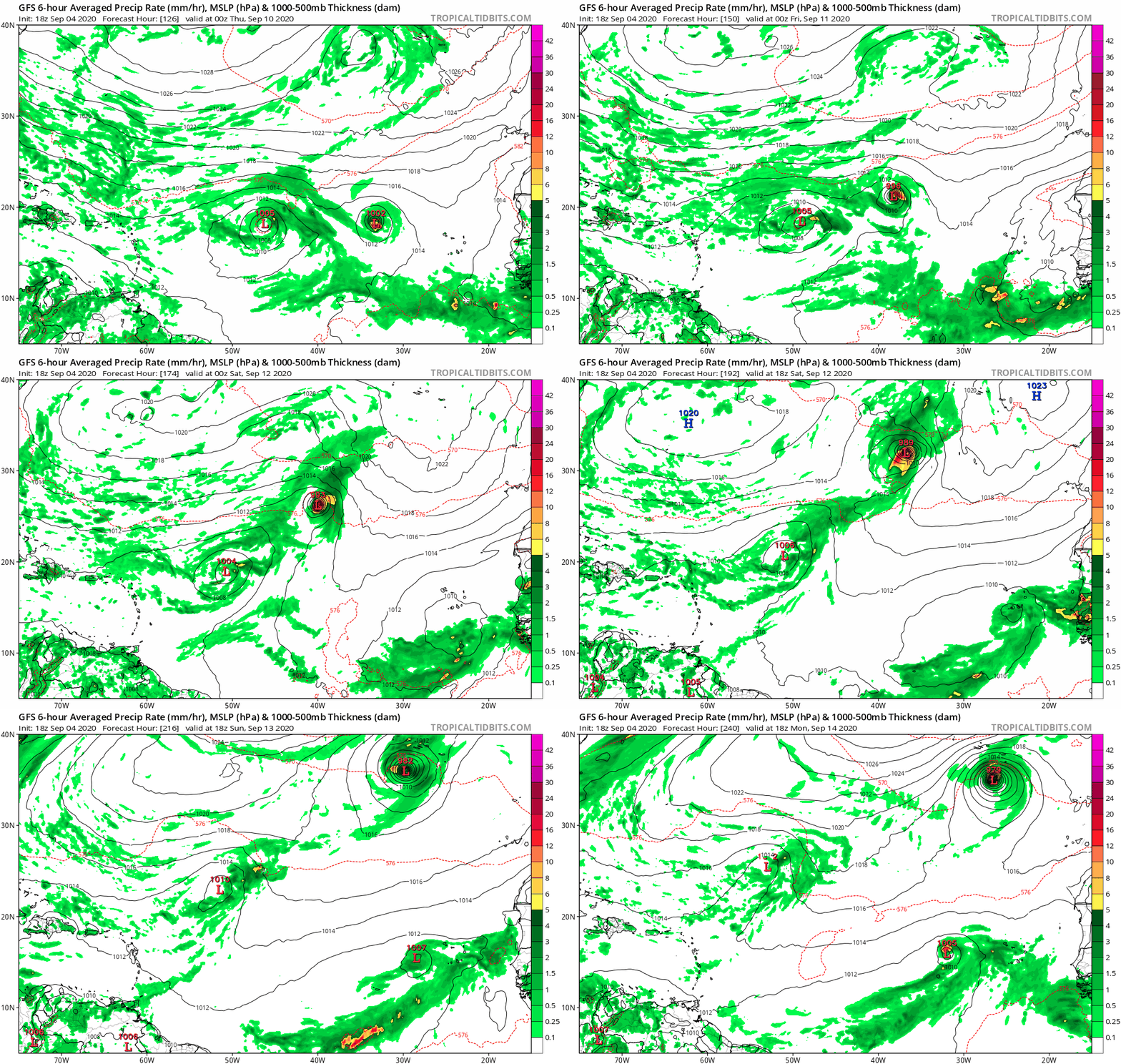
The GFS is recurve city with all of these Cape Verde systems. The timely giant mid-level low is pulling everything north “cleaning house” so to speak 
One storm gets close to the Azores.
Saved loop:
One storm gets close to the Azores.
Saved loop:

1 likes
Re: 2020 Global Model Runs Discussion (Out thru day 16)
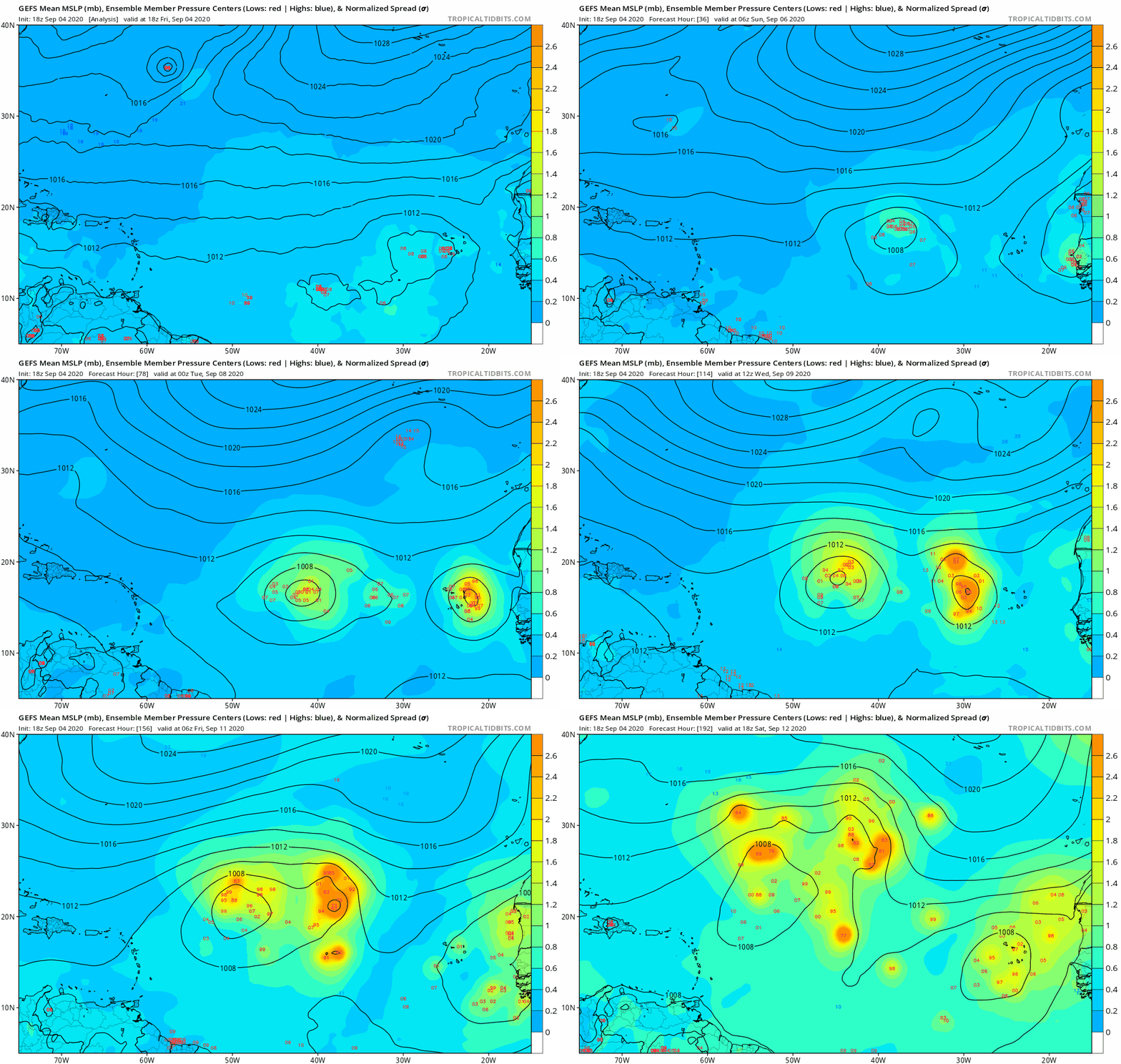
The 18Z GEFS is recurving well OTS/east of the Caribbean just about all members with a TC forming from the wave coming off Africa ~9/10.
0 likes
Personal Forecast Disclaimer:
The posts in this forum are NOT official forecasts and should not be used as such. They are just the opinion of the poster and may or may not be backed by sound meteorological data. They are NOT endorsed by any professional institution or storm2k.org. For official information, please refer to the NHC and NWS products.
The posts in this forum are NOT official forecasts and should not be used as such. They are just the opinion of the poster and may or may not be backed by sound meteorological data. They are NOT endorsed by any professional institution or storm2k.org. For official information, please refer to the NHC and NWS products.
- Spacecoast
- Category 2

- Posts: 773
- Joined: Thu Aug 31, 2017 2:03 pm
Re: 2020 Global Model Runs Discussion (Out thru day 16)
LarryWx wrote:The 18Z GEFS is recurving well OTS/east of the Caribbean just about all members with a TC forming from the wave coming off Africa ~9/10.
There is far west 963mb member that curves the bahamas, E of FL @ hour 324 that originates from the 2nd wave, (not the Sept 10th wave).
It seems truly an outlier to me, though. The GEFS seems to 'spinoff' a few members at a higher velocity (18-19mph?) ahead of the pack soon after genesis.
0 likes
- gatorcane
- S2K Supporter

- Posts: 23708
- Age: 48
- Joined: Sun Mar 13, 2005 3:54 pm
- Location: Boca Raton, FL
Re: 2020 Global Model Runs Discussion (Out thru day 16)
LarryWx wrote:The 18Z GEFS is recurving well OTS/east of the Caribbean just about all members with a TC forming from the wave coming off Africa ~9/10.
Saved loop:
0 likes
Who is online
Users browsing this forum: Kingarabian, ljmac75, Ulf, USTropics and 270 guests


