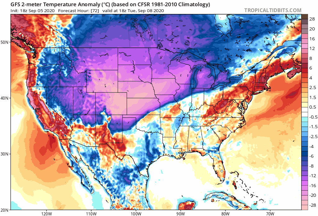
Finally some good news.gatorcane wrote:For those doubting the GFS cold front, it is back to showing quite a front for this time of year with timeframe coming in. This brings lows to mid 50s across the northern Gulf. Also weakens the Bermuda High considerably. The cool weather sticks around for several days if not longer. SSTs across the northern Gulf will take a considerable hit if this happens.
2020 Indicators: SST's / SAL / MSLP / Steering / Shear / Instability / Sat Images
Moderator: S2k Moderators
Forum rules

The posts in this forum are NOT official forecasts and should not be used as such. They are just the opinion of the poster and may or may not be backed by sound meteorological data. They are NOT endorsed by any professional institution or STORM2K. For official information, please refer to products from the National Hurricane Center and National Weather Service.
-
jaxfladude
- Category 5

- Posts: 1249
- Joined: Wed Aug 24, 2005 9:36 pm
- Location: Jacksonville, Fla
Re: RE: Re: 2020 Indicators: SST's / SAL / MSLP / Steering / Shear / Instability / Sat Images
0 likes
Stay safe y'all

Re: 2020 Indicators: SST's / SAL / MSLP / Steering / Shear / Instability / Sat Images
gatorcane wrote:For those doubting the GFS cold front, it is back to showing quite a front for this time of year with timeframe coming in. This brings lows to mid 50s across the northern Gulf. Also weakens the Bermuda High considerably. The cool weather sticks around for several days if not longer. SSTs across the northern Gulf will take a considerable hit if this happens.
https://i.postimg.cc/wMwRpCJR/gfs-T2ma-us-fh72-210-2.gif
Would love a little chill breeze here in Texas
But define “considerable” in this case.
In an average hurricane season/El Nino year I’d agree that this would affect developing systems in the gulf, but in a year such as this year with a very likely La Nina developing, the surface temperatures could merely shrink to the low 80’s....soooo it hardly makes much a difference. The cold wake left by Hanna, Marco, and Laura, etc, weren’t even really “cold” just again lower 80’s.
Does colder air make a difference in the moisture or vapor level that could affect storms?
2 likes
-
TheStormExpert
Re: 2020 Indicators: SST's / SAL / MSLP / Steering / Shear / Instability / Sat Images
So basically we had a mostly-NAO all summer that behaved like a +NAO with stronger than normal ridging in the NW Atlantic. Now we have a +NAO and an anomalously strong cold front sweeps through the U.S.? 
3 likes
-
Shell Mound
- Category 5
- Posts: 2432
- Age: 33
- Joined: Thu Sep 07, 2017 3:39 pm
- Location: St. Petersburg, FL → Scandinavia
Re: 2020 Indicators: SST's / SAL / MSLP / Steering / Shear / Instability / Sat Images
TheStormExpert wrote:So basically we had a mostly-NAO all summer that behaved like a +NAO with stronger than normal ridging in the NW Atlantic. Now we have a +NAO and an anomalously strong cold front sweeps through the U.S.?
The fact that 92L and 93L exited Africa at relatively high latitudes portends good news for most land masses, at least in the short term. A more northerly ITCZ relative to normal indicates highly conducive conditions for early development of African easterly waves and thus increases the likelihood of OTS tracks. Even with very strong ridging in place, 92L and 93L should struggle to affect the islands or the East Coast of the U.S., simply based on their respective locations. However, Bermuda should definitely pay close attention.
0 likes
CVW / MiamiensisWx / Shell Mound
The posts in this forum are NOT official forecasts and should not be used as such. They are just the opinion of the poster and may or may not be backed by sound meteorological data. They are NOT endorsed by any professional institution or STORM2K. For official information, please refer to products from the NHC and NWS.
-
TheStormExpert
Re: 2020 Indicators: SST's / SAL / MSLP / Steering / Shear / Instability / Sat Images
Shell Mound wrote:TheStormExpert wrote:So basically we had a mostly-NAO all summer that behaved like a +NAO with stronger than normal ridging in the NW Atlantic. Now we have a +NAO and an anomalously strong cold front sweeps through the U.S.?
The fact that 92L and 93L exited Africa at relatively high latitudes portends good news for most land masses, at least in the short term. A more northerly ITCZ relative to normal indicates highly conducive conditions for early development of African easterly waves and thus increases the likelihood of OTS tracks. Even with very strong ridging in place, 92L and 93L should struggle to affect the islands or the East Coast of the U.S., simply based on their respective locations. However, Bermuda should definitely pay close attention.
Irma came off at a high latitude as well and made the track all the way across. The pattern is too progressive this time.
2 likes
-
toad strangler

- S2K Supporter

- Posts: 4546
- Joined: Sun Jul 28, 2013 3:09 pm
- Location: Earth
- Contact:
Re: 2020 Indicators: SST's / SAL / MSLP / Steering / Shear / Instability / Sat Images
I'd say at this point that the Cape or Cabo Verde season as far as threats to the CONUS is all but finished. This is for true Verde systems that get classified way out East. THe islands and Bermuda though a different story.
1 likes
My Weather Station
https://www.wunderground.com/dashboard/pws/KFLPORTS603
https://www.wunderground.com/dashboard/pws/KFLPORTS603
-
TheStormExpert
Re: 2020 Indicators: SST's / SAL / MSLP / Steering / Shear / Instability / Sat Images
toad strangler wrote:I'd say at this point that the Cape or Cabo Verde season as far as threats to the CONUS is all but finished. This is for true Verde systems that get classified way out East. THe islands and Bermuda though a different story.
Maybe in another month. Kind of premature to make a statement like this only on September 6th, hopefully you’re right though!
5 likes
Re: 2020 Indicators: SST's / SAL / MSLP / Steering / Shear / Instability / Sat Images
toad strangler wrote:I'd say at this point that the Cape or Cabo Verde season as far as threats to the CONUS is all but finished. This is for true Verde systems that get classified way out East. THe islands and Bermuda though a different story.
Based on where we are and what (more like hasn't) happened thus far I'd say the odds are you are going to be correct. In all likelihood, the cannon would have already needed to have fired (like Irma 2017). Sand is dumping through the hourglass now big time. As always we still have to wait but each day the scale tilts meaningfully. Weren't we supposed to have an "outbreak" of TCs with an extremely dangerous steering pattern now? I find it difficult to trust anything right now...other than the calendar...which screams "dance" and we keep finding ways not to. It's a victory for those looking for out of season tranquility (as far as land threats go)...Time to hit the beach...our shelf water has recovered back to 90ish.. a reminder that we're still walking on eggshells.
2 likes
Re: 2020 Indicators: SST's / SAL / MSLP / Steering / Shear / Instability / Sat Images
TheStormExpert wrote:toad strangler wrote:I'd say at this point that the Cape or Cabo Verde season as far as threats to the CONUS is all but finished. This is for true Verde systems that get classified way out East. THe islands and Bermuda though a different story.
Maybe in another month. Kind of premature to make a statement like this only on September 6th, hopefully you’re right though!
By Sep 15 or so, the chances that the CONUS will be hit by an E MDR storm forming after then (I don't mean hit date as the CONUS has been hit by some in the 20s of Sep like Hugo and Gloria for example and in early Oct like Lili and Inez) the rest of the season are already dropping rapidly. The very latest genesis date east of 50W that later hit the CONUS was Sep 25 and that was in 1893. Since then the latest was Sep 21 (Lili of 2002 and Inez of 1966).
The peak of E MDR genesis frequency for CONUS hitting storms has been 8/15-9/11. We still have a ways to go considering 92L, 93L, and what may or may not form ~9/10-11. If we can get past these 3 and nothing new is then showing up on model consensus, I'd then feel pretty darn good about the CONUS not getting hit by an E MDR forming storm the rest of the season.
Hopefully all 3 systems will behave.
Last edited by LarryWx on Sun Sep 06, 2020 2:57 pm, edited 4 times in total.
2 likes
Personal Forecast Disclaimer:
The posts in this forum are NOT official forecasts and should not be used as such. They are just the opinion of the poster and may or may not be backed by sound meteorological data. They are NOT endorsed by any professional institution or storm2k.org. For official information, please refer to the NHC and NWS products.
The posts in this forum are NOT official forecasts and should not be used as such. They are just the opinion of the poster and may or may not be backed by sound meteorological data. They are NOT endorsed by any professional institution or storm2k.org. For official information, please refer to the NHC and NWS products.
-
toad strangler
- S2K Supporter
- Posts: 4546
- Joined: Sun Jul 28, 2013 3:09 pm
- Location: Earth
- Contact:
Re: 2020 Indicators: SST's / SAL / MSLP / Steering / Shear / Instability / Sat Images
psyclone wrote:toad strangler wrote:I'd say at this point that the Cape or Cabo Verde season as far as threats to the CONUS is all but finished. This is for true Verde systems that get classified way out East. THe islands and Bermuda though a different story.
Based on where we are and what (more like hasn't) happened thus far I'd say the odds are you are going to be correct. In all likelihood, the cannon would have already needed to have fired (like Irma 2017). Sand is dumping through the hourglass now big time. As always we still have to wait but each day the scale tilts meaningfully. Weren't we supposed to have an "outbreak" of TCs with an extremely dangerous steering pattern now? I find it difficult to trust anything right now...other than the calendar...which screams "dance" and we keep finding ways not to. It's a victory for those looking for out of season tranquility (as far as land threats go)...Time to hit the beach...our shelf water has recovered back to 90ish.. a reminder that we're still walking on eggshells.
Well if anybody reads my posts they would know that I don't ever cancel or even talk about the possibility until it's a dead beat horse
DISCLAIMER: THis obviously does not have anything to do with waves or other bundles of energy that spark up much further west. We obviously have a long way to go still in that regard.
5 likes
My Weather Station
https://www.wunderground.com/dashboard/pws/KFLPORTS603
https://www.wunderground.com/dashboard/pws/KFLPORTS603

Re: 2020 Indicators: SST's / SAL / MSLP / Steering / Shear / Instability / Sat Images
I haven’t been watching the WPAC because because it’s been so slow. Heishen isn’t recurving ng according to the most recent track by the JTWC.
https://www.metoc.navy.mil/jtwc/products/wp1120.gif
Not saying that’s what’s exactly going to happen but the teleconnection would be a farther west trough in the US. It also argues for amplification with very slow progression of anything in the Atlantic or possibly a slow climb northward.
https://www.metoc.navy.mil/jtwc/products/wp1120.gif
Not saying that’s what’s exactly going to happen but the teleconnection would be a farther west trough in the US. It also argues for amplification with very slow progression of anything in the Atlantic or possibly a slow climb northward.
Last edited by Steve on Sun Sep 06, 2020 3:40 pm, edited 1 time in total.
2 likes
-
TheStormExpert
Re: 2020 Indicators: SST's / SAL / MSLP / Steering / Shear / Instability / Sat Images
toad strangler wrote:psyclone wrote:toad strangler wrote:I'd say at this point that the Cape or Cabo Verde season as far as threats to the CONUS is all but finished. This is for true Verde systems that get classified way out East. THe islands and Bermuda though a different story.
Based on where we are and what (more like hasn't) happened thus far I'd say the odds are you are going to be correct. In all likelihood, the cannon would have already needed to have fired (like Irma 2017). Sand is dumping through the hourglass now big time. As always we still have to wait but each day the scale tilts meaningfully. Weren't we supposed to have an "outbreak" of TCs with an extremely dangerous steering pattern now? I find it difficult to trust anything right now...other than the calendar...which screams "dance" and we keep finding ways not to. It's a victory for those looking for out of season tranquility (as far as land threats go)...Time to hit the beach...our shelf water has recovered back to 90ish.. a reminder that we're still walking on eggshells.
Well if anybody reads my posts they would know that I don't ever cancel or even talk about the possibility until it's a dead beat horseSo take that for what it's worth. I'm feeling pretty confident that it's over for true long track Verde origination hits on the CONUS.
DISCLAIMER: THis obviously does not have anything to do with waves or other bundles of energy that spark up much further west. We obviously have a long way to go still in that regard.
How can it be over when it really never even started!
1 likes
-
TheStormExpert
Re: 2020 Indicators: SST's / SAL / MSLP / Steering / Shear / Instability / Sat Images
Steve wrote:I haven’t been watching the WPAC because because it’s been so slow. Heishen isn’t receiving according to the most recent track by the JTWC.
https://www.metoc.navy.mil/jtwc/products/wp1120.gif
Not saying that’s what’s exactly going to happen but the teleconnection would be a farther west trough in the US. It also argues for amplification with very slow progression of anything in the Atlantic or possibly a slow climb northward.
Yep, the NAO is positive for anyone who actually pays attention to teleconnections.
1 likes
Re: 2020 Indicators: SST's / SAL / MSLP / Steering / Shear / Instability / Sat Images
The CONUS has been hit by an E MDR genesis (east of 50W) four years in a row:
Irma (gen 8/29/2017), Florence (gen 8/31/2018), Dorian (gen 8/24/2019), and Laura (gen 8/19/2020)
Even during this current +AMO of the satellite era, that's a rather high frequency. They went 2013-16 without even one, including the active 2016 (15 storms). The very active 2011 and 1995 (each with 19 NS) had none. The years 2007, 2001, and 2000, each of which had an active 15 NS, had none.
So, as far as 2020 is concerned, keep all of this in mind IF there are no more CONUS hits from E MDR storms, especially since there's already been one (Laura). There's nothing weak about this season overall in terms of CONUS impacts no matter what happens from here on out.
8 likes
Personal Forecast Disclaimer:
The posts in this forum are NOT official forecasts and should not be used as such. They are just the opinion of the poster and may or may not be backed by sound meteorological data. They are NOT endorsed by any professional institution or storm2k.org. For official information, please refer to the NHC and NWS products.
The posts in this forum are NOT official forecasts and should not be used as such. They are just the opinion of the poster and may or may not be backed by sound meteorological data. They are NOT endorsed by any professional institution or storm2k.org. For official information, please refer to the NHC and NWS products.
Re: 2020 Indicators: SST's / SAL / MSLP / Steering / Shear / Instability / Sat Images
TheStormExpert wrote:Steve wrote:I haven’t been watching the WPAC because because it’s been so slow. Heishen isn’t receiving according to the most recent track by the JTWC.
https://www.metoc.navy.mil/jtwc/products/wp1120.gif
Not saying that’s what’s exactly going to happen but the teleconnection would be a farther west trough in the US. It also argues for amplification with very slow progression of anything in the Atlantic or possibly a slow climb northward.
Yep, the NAO is positive for anyone who actually pays attention to teleconnections.
It has been, though like you said there has been a progressive pattern (particularly with the northern jet). Odd is that on a storm to storm basis a hit on South Korea usually translates to something around Florida. Since neither of the major Atlantic waves look to be able to make it all that far west, it would have to be something else toward next weekend if there is going to be a storm teleconnection.
0 likes
-
TheStormExpert

Re: 2020 Indicators: SST's / SAL / MSLP / Steering / Shear / Instability / Sat Images
TheStormExpert wrote:How can it be over when it really never even started!
That's exactly what I was going to say
There should be a way to tag posts based on steering and TC fuel.
1 likes
-
TheStormExpert
Re: 2020 Indicators: SST's / SAL / MSLP / Steering / Shear / Instability / Sat Images
Cyclenall wrote:TheStormExpert wrote:How can it be over when it really never even started!
That's exactly what I was going to say. Every season it's the same thing.
There should be a way to tag posts based on steering and TC fuel.
This season has been oddly strange to say the least. I mean we are currently out beating 2005’s named storms pace but ACE is in third place globally and Cape Verde has yet to really get going.
2 likes
-
toad strangler
- S2K Supporter
- Posts: 4546
- Joined: Sun Jul 28, 2013 3:09 pm
- Location: Earth
- Contact:
Re: 2020 Indicators: SST's / SAL / MSLP / Steering / Shear / Instability / Sat Images
TheStormExpert wrote:Cyclenall wrote:TheStormExpert wrote:How can it be over when it really never even started!
That's exactly what I was going to say
There should be a way to tag posts based on steering and TC fuel.
This season has been oddly strange to say the least. I mean we are currently out beating 2005’s named storms pace but ACE is in third place globally and Cape Verde has yet to really get going.
Tropical seasons are never the same nor do they follow scripts. You seem to think there is some sort of normal framework.
5 likes
My Weather Station
https://www.wunderground.com/dashboard/pws/KFLPORTS603
https://www.wunderground.com/dashboard/pws/KFLPORTS603
-
TheStormExpert
Re: 2020 Indicators: SST's / SAL / MSLP / Steering / Shear / Instability / Sat Images
toad strangler wrote:TheStormExpert wrote:Cyclenall wrote: That's exactly what I was going to say
There should be a way to tag posts based on steering and TC fuel.
This season has been oddly strange to say the least. I mean we are currently out beating 2005’s named storms pace but ACE is in third place globally and Cape Verde has yet to really get going.
Tropical seasons are never the same nor do they follow scripts. You seem to think there is some sort of normal framework.
There is no normal especially in 2020. But we should be well into the midst of Cape Verde season. Currently we have two well organized invests in the Tropical Atlantic that lack significant deep convection. But will likely develop at some point.
0 likes
Who is online
Users browsing this forum: No registered users and 118 guests