Looks to be about 13N.


Moderator: S2k Moderators


blp wrote:Here is what he is talking about:
https://uploads.disquscdn.com/images/2511cfd537aa98d8c92b73401e70f031cc4b19f466edbdfa11066ba4a14f651a.png
AutoPenalti wrote:blp wrote:Here is what he is talking about:
https://uploads.disquscdn.com/images/2511cfd537aa98d8c92b73401e70f031cc4b19f466edbdfa11066ba4a14f651a.png
That's 12z...
I'm thinking he's talking about 18z early guidance.


Hypercane_Kyle wrote:TheStormExpert wrote:12z Euro MUCH weaker.
Horrendous consistency. 00z yesterday was a major hurricane, 12z yesterday was a weak tropical storm, 00z run was a major hurricane, 12z run back to a tropical storm.
Frustrating how poorly this model has performed this season in terms of intensity.


Blown Away wrote:https://i.imgur.com/uGhAOkJ.gif
12z EURO... 144-240 Hours... After raking the islands looks like a recurve over E Cuba into SE Bahamas/SE FL area... Long way out...
AutoPenalti wrote:
Okay so maybe that wasn't 18z...
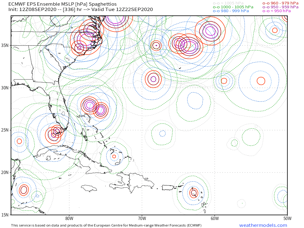
Shell Mound wrote:cycloneye wrote:Shell Mound wrote:I’m not sure as to why people see these solutions as threatening. Until we get an actual system, preferably named, with a well-defined LLC, any modelled solution is bound to be far from reality. Respectfully, even if a professional meteorologist regards this AEW as a threat, I, personally speaking, would not be so bullish as to “sound the alarm” at this premature stage. This AEW is at least three days’ distance from the easternmost tropical Atlantic. The EPS continues to advertise a progressive pattern through the long range, which would reduce the risk of a landfall, given troughs continually eroding the WAR. Additionally, the 00Z ECMWF suggests that this AEW would near the longitude of the islands on September 18, meaning any landfall on the mainland U.S. would occur three days later—a very late date, climatologically speaking, for a long-tracking CV system to strike the U.S. mainland. At this stage, even if this system develops, I believe it will most likely curve OTS or threaten Bermuda, like Paulette and Rene. Of course, this conclusion is preliminary and probabilistic.
Hate to get somewhat political but PR is part of the U.S as a territory as well the U.S Virgin Islands.
I know, but I think this AEW will end up missing the islands as well as the mainland U.S., like Paulette and Rene. I certainly hope so. We’ll see.


TheStormExpert wrote:
Still mostly in The Bahamas and off the Florida coastline. Still too close for comfort but it’s nearly two weeks out and going to change. The pattern remains progressive and will likely do so, not to mention the ensembles show the NAO trending back negative in two weeks.


Users browsing this forum: cycloneye and 291 guests


