Tropical Wave has emerged from West Africa (Is Invest 95L)

This is the general tropical discussion area. Anyone can take their shot at predicting a storms path.

Moderator: S2k Moderators

Forum rules

The posts in this forum are NOT official forecasts and should not be used as such. They are just the opinion of the poster and may or may not be backed by sound meteorological data. They are NOT endorsed by any professional institution or STORM2K. For official information, please refer to products from the National Hurricane Center and National Weather Service.

Help Support Storm2K
Message
Author
sma10
Category 5
Category 5
Posts: 1710
Joined: Tue Aug 02, 2005 1:13 pm

Re: Tropical Wave has emerged from West Africa

#581 Postby sma10 » Thu Sep 10, 2020 2:47 pm

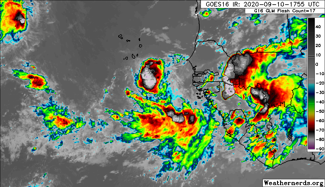
FireRat wrote:Guys really? Yeah climo usually favors OTS this deep into September, but it's 2020. How about we wait until an invest is declared, and better yet wait until we do have a named storm. I would wishcast for an OTS myself, the islands don't need another hurricane especially this year and so soon after Irma/Maria.

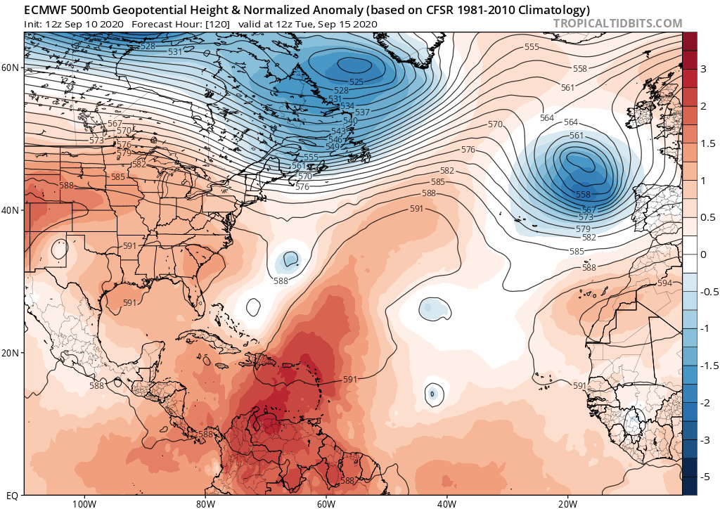
The threat is there, the cannonball is being shot out of Africa, now we wait and see how the trajectory will go. I guess based on the preliminary model estimates, there's a 2/3 chance it will be a fish storm, and well you know the other 1/3... which is kinda significant enough to not take too lightly. Hopefully in the days ahead we'll see if indeed Sally/Teddy becomes a fish, and a big fish at that.

Then again, this situation is more complex with so many systems out there, so naturally this could be screwing with the models on track a bit. A better track modeling will come once the storm is more organized, so again too soon to say where it will go and we just gotta patiently watch it and see what becomes clearer down the road.


Yup 1/3 is certainly significant. As I like to think of it - an outcome with a 1/3 probability is the same as a career .333 player getting a base hit (i.e. not that much of a long shot)
2 likes   

User avatar
SFLcane
S2K Supporter
S2K Supporter
Posts: 10163
Age: 47
Joined: Sat Jun 05, 2010 1:44 pm
Location: Lake Worth Florida

Re: Tropical Wave has emerged from West Africa

#582 Postby SFLcane » Thu Sep 10, 2020 2:49 pm

0 likes   

User avatar
NDG
S2K Supporter
S2K Supporter
Posts: 15446
Joined: Sun Jul 09, 2006 10:14 pm
Location: Orlando, FL

Re: Tropical Wave has emerged from West Africa

#583 Postby NDG » Thu Sep 10, 2020 2:49 pm

Euro really throws a curved ball at us with that strong cold front it now shows coming across the eastern US on its long range forecast.

Image
0 likes   

User avatar
SouthFLTropics
Category 5
Category 5
Posts: 4236
Age: 50
Joined: Thu Aug 14, 2003 8:04 am
Location: Port St. Lucie, Florida

Re: Tropical Wave has emerged from West Africa

#584 Postby SouthFLTropics » Thu Sep 10, 2020 2:52 pm

Those are still some pretty substantial Euro ensemble members that rake through the islands. One run of an operational model a trend it does not make. (Said in my best Yoda voice)


Sent from my iPhone using Tapatalk
0 likes   
Fourth Generation Florida Native

Personal Storm History: David 79, Andrew 92, Erin 95, Floyd 99, Irene 99, Frances 04, Jeanne 04, Wilma 05, Matthew 16, Irma 17, Ian 22, Nicole 22, Milton 24

User avatar
gatorcane
S2K Supporter
S2K Supporter
Posts: 23691
Age: 47
Joined: Sun Mar 13, 2005 3:54 pm
Location: Boca Raton, FL

Re: Tropical Wave has emerged from West Africa

#585 Postby gatorcane » Thu Sep 10, 2020 2:53 pm

NDG wrote:Euro really throws a curved ball at us with that strong cold front it now shows coming across the eastern US on its long range forecast.

https://i.imgur.com/iHCDgmf.png


I was just going to post that. Big difference between the GFS and Euro in the long-range as far as the 500MB pattern even if the Euro sent a hurricane west through the Caribbean like the GFS. The Euro has a strong cold front now. Of course details will change as this is long-range:

Image
0 likes   

User avatar
NDG
S2K Supporter
S2K Supporter
Posts: 15446
Joined: Sun Jul 09, 2006 10:14 pm
Location: Orlando, FL

Re: Tropical Wave has emerged from West Africa

#586 Postby NDG » Thu Sep 10, 2020 2:57 pm

SouthFLTropics wrote:Those are still some pretty substantial Euro ensemble members that rake through the islands. One run of an operational model a trend it does not make. (Said in my best Yoda voice)


Sent from my iPhone using Tapatalk


Yes, that's nearly half of its ensemble members that still show a potential hit to the islands.
0 likes   

User avatar
Nimbus
Category 5
Category 5
Posts: 5300
Joined: Mon Jul 19, 2004 10:54 am

Re: Tropical Wave has emerged from West Africa

#587 Postby Nimbus » Thu Sep 10, 2020 2:58 pm

We forecast these storms to all head north OTS like ducklings weeks ago *but*

If the current weaker Paulette doesn't strengthen she won't have much influence south of the Cape Verde islands.
A weaker wave stays closer to the ITCZ and trends more west because of the surface flow.
A stronger storm coming off the African coast behind this current wave would tend to counteract Paulette's steering.
If any ridging develops between Paulette and this new wave that would ensure the southern outlying track.

Looks like the sudden recurve is due to both Paulette and the new storm intensifying uncomfortably late.
1 likes   

Deshaunrob17
Tropical Storm
Tropical Storm
Posts: 207
Joined: Tue Aug 18, 2020 7:49 am

Re: Tropical Wave has emerged from West Africa

#588 Postby Deshaunrob17 » Thu Sep 10, 2020 3:01 pm

I had feeling something seemed fishy about the Caribbean Cruiser solution... Too much wave breaking in mid latitudes, lots of other cyclones involved and climatology... I’m not writing off a Caribbean Cruiser but OTS seems more favored to me...The only way I see a Caribbean Cruiser happening is if it moves very fast and remains very disorganized until Lesser Antillies...
1 likes   

User avatar
NDG
S2K Supporter
S2K Supporter
Posts: 15446
Joined: Sun Jul 09, 2006 10:14 pm
Location: Orlando, FL

Re: Tropical Wave has emerged from West Africa

#589 Postby NDG » Thu Sep 10, 2020 3:05 pm

EPS does not agree with such a deep trough that the Euro operational now shows for the eastern US.

Image
Image
1 likes   

Aric Dunn
Category 5
Category 5
Posts: 21238
Age: 42
Joined: Sun Sep 19, 2004 9:58 pm
Location: Ready for the Chase.
Contact:

Re: Tropical Wave has emerged from West Africa

#590 Postby Aric Dunn » Thu Sep 10, 2020 3:07 pm

gatorcane wrote:
NDG wrote:Euro really throws a curved ball at us with that strong cold front it now shows coming across the eastern US on its long range forecast.

https://i.imgur.com/iHCDgmf.png


I was just going to post that. Big difference between the GFS and Euro in the long-range as far as the 500MB pattern even if the Euro sent a hurricane west through the Caribbean like the GFS. The Euro has a strong cold front now. Of course details will change as this is long-range:

https://i.postimg.cc/sxRWWGwF/ecmwf-z500a-Norm-atl-fh120-240.gif


its actually a quick weak clipper type trough that stalls in the south and starts to develop some STS or ST at the end..

Image
2 likes   
Note: If I make a post that is brief. Please refer back to previous posts for the analysis or reasoning. I do not re-write/qoute what my initial post said each time.
If there is nothing before... then just ask :)

Space & Atmospheric Physicist, Embry-Riddle Aeronautical University,
I believe the sky is falling...

User avatar
NDG
S2K Supporter
S2K Supporter
Posts: 15446
Joined: Sun Jul 09, 2006 10:14 pm
Location: Orlando, FL

Re: Tropical Wave has emerged from West Africa

#591 Postby NDG » Thu Sep 10, 2020 3:28 pm

By no means the Euro's operational is not perfect past its 5 day range forecast as we get into day 10, it is very inconsistent & erroneous. Better to go with its consensus in that time frame.

Image
Image
4 likes   

User avatar
SFLcane
S2K Supporter
S2K Supporter
Posts: 10163
Age: 47
Joined: Sat Jun 05, 2010 1:44 pm
Location: Lake Worth Florida

Re: Tropical Wave has emerged from West Africa

#592 Postby SFLcane » Thu Sep 10, 2020 3:44 pm

NDG wrote:By no means the Euro's operational is not perfect past its 5 day range forecast as we get into day 10, it is very inconsistent & erroneous. Better to go with its consensus in that time frame.

https://i.imgur.com/co559VL.gif
https://i.imgur.com/OXxSILI.gif


Yeah it's a little volatile... We are back to the east coast trough though. That's why 12z suite is fish city.
0 likes   

User avatar
crownweather
S2K Supporter
S2K Supporter
Posts: 595
Age: 50
Joined: Sat Aug 12, 2006 9:21 am
Location: Sturbridge, Massachusetts
Contact:

Re: Tropical Wave has emerged from West Africa

#593 Postby crownweather » Thu Sep 10, 2020 3:53 pm

gatorcane wrote:
NDG wrote:Euro really throws a curved ball at us with that strong cold front it now shows coming across the eastern US on its long range forecast.

https://i.imgur.com/iHCDgmf.png


I was just going to post that. Big difference between the GFS and Euro in the long-range as far as the 500MB pattern even if the Euro sent a hurricane west through the Caribbean like the GFS. The Euro has a strong cold front now. Of course details will change as this is long-range:

https://i.postimg.cc/sxRWWGwF/ecmwf-z500a-Norm-atl-fh120-240.gif


Past experience I've had with the European deterministic model is that it tends to over amplify troughs and over strengthen storms at days 8, 9 and 10. Usually what ends up occurring is that you end up trending towards a weaker trough/storm as you get closer in in time.
1 likes   
Rob Lightbown
Crown Weather Services
https://crownweather.com

User avatar
aspen
Category 5
Category 5
Posts: 8818
Joined: Sat Oct 12, 2019 7:10 pm
Location: Connecticut, USA

Re: Tropical Wave has emerged from West Africa

#594 Postby aspen » Thu Sep 10, 2020 4:15 pm

The GFS isn’t alone with the two storms/Caribbean Cruiser scenario. If you view the HWRF-P run for Rene, you can see that same scenario play out (although the Caribbean Cruiser is barely in the bottom of the FoV). The HWRF/HWRF-P show Paulette becoming a Cat 3 in 4-5 days and Rene dissipating in the same time frame. It does not become a hurricane, nor do its remnants do any crazy loops.
0 likes   
Irene '11 Sandy '12 Hermine '16 5/15/2018 Derecho Fay '20 Isaias '20 Elsa '21 Henri '21 Ida '21

I am only a meteorology enthusiast who knows a decent amount about tropical cyclones. Look to the professional mets, the NHC, or your local weather office for the best information.

LarryWx
S2K Supporter
S2K Supporter
Posts: 6301
Joined: Sun Sep 07, 2003 2:04 pm
Location: GA

Re: Tropical Wave has emerged from West Africa

#595 Postby LarryWx » Thu Sep 10, 2020 4:15 pm

chris_fit wrote:12Z EPS split into two camps.....

1.) Recurve like the Operations (2/3 members)
2.) West like the GFS (1/3 members)


https://i.imgur.com/jLBtnM6.png


Indeed this 12Z EPS is less threatening than the 0Z EPS, which I posted late last night with the :eek: :eek: :eek: . So, hopefully the 12Z Euro suite is more representative of the risk than that very scary 0z Euro suite. Who the heck knows as the models keep jumping back and forth from higher risk to lower risk. I hope and pray that early recurves reappear again on models with frequency just as they did at 12Z yesterday.
0 likes   
Personal Forecast Disclaimer:
The posts in this forum are NOT official forecasts and should not be used as such. They are just the opinion of the poster and may or may not be backed by sound meteorological data. They are NOT endorsed by any professional institution or storm2k.org. For official information, please refer to the NHC and NWS products.

Cat5James
Category 1
Category 1
Posts: 417
Joined: Fri Sep 06, 2019 7:54 pm

Re: Tropical Wave has emerged from West Africa

#596 Postby Cat5James » Thu Sep 10, 2020 4:17 pm

18Z Icon farther west through 72 hours... sticking with a split system with southern lobe moving west
0 likes   

User avatar
SouthDadeFish
Professional-Met
Professional-Met
Posts: 2835
Joined: Thu Sep 23, 2010 2:54 pm
Location: Miami, FL
Contact:

Re: Tropical Wave has emerged from West Africa

#597 Postby SouthDadeFish » Thu Sep 10, 2020 4:19 pm

Breaking news: 10-day forecasts tend to vary dramatically from run-to-run. :lol:

I think more time should be spent focusing on short-term trends, which are more predictable, but still tricky. We have to see where a TC forms. I also think the interaction of Paulette with the mid-latitude waveguide will also be very important.
3 likes   

User avatar
SFLcane
S2K Supporter
S2K Supporter
Posts: 10163
Age: 47
Joined: Sat Jun 05, 2010 1:44 pm
Location: Lake Worth Florida

Re: Tropical Wave has emerged from West Africa

#598 Postby SFLcane » Thu Sep 10, 2020 4:20 pm

Image
1 likes   

User avatar
Spacecoast
Category 2
Category 2
Posts: 758
Joined: Thu Aug 31, 2017 2:03 pm

Re: Tropical Wave has emerged from West Africa

#599 Postby Spacecoast » Thu Sep 10, 2020 4:20 pm

12z GEFS Genesis Probabilities: This wave = 55% (NHC:60/90%).
The wave after that, (exiting 9/12) =85% (NHC:0/40%):

Image

I wonder how much future track depends on interaction between these two waves over the next 3 days.
GEFS says they will be in close proxity to each other @48hrs, with the next wave being little stronger in terms of vorticity, & MSLP
This wave 0-144hr:
Image

The next wave (9/12) 0-144hr:
Image
1 likes   

User avatar
Hurricanehink
S2K Supporter
S2K Supporter
Posts: 2040
Joined: Sun Nov 16, 2003 2:05 pm
Location: New Jersey

Re: Tropical Wave has emerged from West Africa

#600 Postby Hurricanehink » Thu Sep 10, 2020 4:20 pm

30 pages for a tropical wave that has only just emerged from West Africa, and it isn't an invest yet. It must be the peak of the hurricane season :lol:
1 likes   


Return to “Talkin' Tropics”

Who is online

Users browsing this forum: Cpv17 and 20 guests