
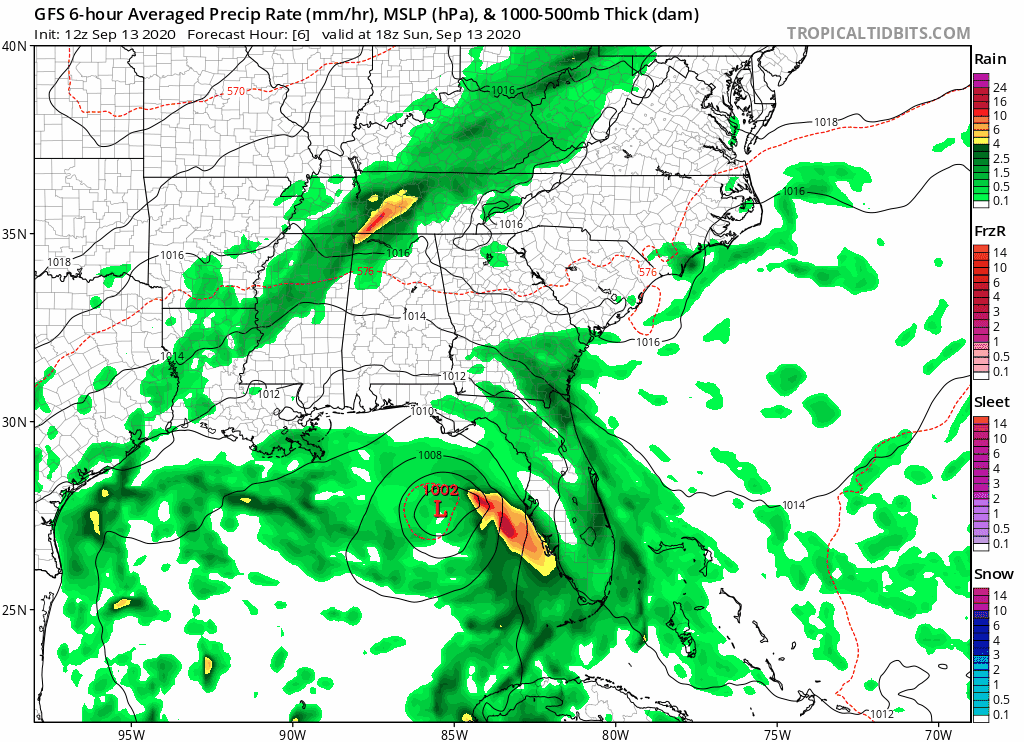
Gfs rolling. Thru 24 hrs a north East of last run. It initialized a little weak but not sure gfs resolves that very well anyway. Guessing 1002 on gfs I probably akin to 990s anyway.
Looks like it will come more East of the mouth if ms this time but hard to say after.
At 30 still a bit East of the mouth. Couple mb weaker
36 hr it bumps a tad west south west to still come to the mouth...not sure I buy that. To me that just spells slowdown ...strength catches back up to last run though
By 48 bumps just east side of New Orleans up the pearl River state line almost. A good jump East from last couple runs. Expect to see hmon and Hwrf follow. We shall see.
ATL: SALLY - Models
Moderator: S2k Moderators
Re: ATL: SALLY - Models
Last edited by PTPatrick on Sun Sep 13, 2020 10:45 am, edited 1 time in total.
1 likes
-
MidnightRain

- Tropical Storm

- Posts: 110
- Joined: Tue Oct 11, 2011 8:26 pm
- Location: NW Florida
Re: ATL: SALLY - Models
Models seem to be agreeing on a west “shove” just prior to landfall.PTPatrick wrote:Gfs rolling. Thru 24 hrs a north East of last run. It initialized a little weak but not sure gfs resolves that very well anyway. Guessing 1002 on gfs I probably akin to 990s anyway.
Looks like it will come more East of the mouth if ms this time but hard to say after.
At 30 still a bit East of the mouth. Couple mb weaker
36 hr it bumps a tad west south west to still come to the mouth...not sure I buy that. To me that just spells slowdown ...strength catches back up to last run though
0 likes
The posts in this forum are NOT official forecast and should not be used as such. They are just the opinion of the poster and may or may not be backed by sound meteorological data. They are NOT endorsed by any professional institution or storm2k.org. For official information, please refer to the NHC and NWS products.

Re: ATL: SALLY - Models
MidnightRain wrote:Models seem to be agreeing on a west “shove” just prior to landfall.PTPatrick wrote:Gfs rolling. Thru 24 hrs a north East of last run. It initialized a little weak but not sure gfs resolves that very well anyway. Guessing 1002 on gfs I probably akin to 990s anyway.
Looks like it will come more East of the mouth if ms this time but hard to say after.
At 30 still a bit East of the mouth. Couple mb weaker
36 hr it bumps a tad west south west to still come to the mouth...not sure I buy that. To me that just spells slowdown ...strength catches back up to last run though
With this icon and gfs run I would not be surprised to see the suites pull back to a final Shell beach or Hancock Or even Harrison county landfall. They have more of a center now and the cake is nearly baked. The problem is steering at 36-48 hrs looks to weaken. That slow down near the mouth of the river really opens up options from AL to Baton Rouge. Slow down and turn in this region is Always a tricky proposition, but I think storms in this area more often than not end up a tad East of their 48 Hr points. Hence, I am feeling like East side of Nola to west of Biloxi seems to be the target zone.
4 likes
Re: ATL: SALLY - Models
PTPatrick wrote:MidnightRain wrote:Models seem to be agreeing on a west “shove” just prior to landfall.PTPatrick wrote:Gfs rolling. Thru 24 hrs a north East of last run. It initialized a little weak but not sure gfs resolves that very well anyway. Guessing 1002 on gfs I probably akin to 990s anyway.
Looks like it will come more East of the mouth if ms this time but hard to say after.
At 30 still a bit East of the mouth. Couple mb weaker
36 hr it bumps a tad west south west to still come to the mouth...not sure I buy that. To me that just spells slowdown ...strength catches back up to last run though
With this icon and gfs run I would not be surprised to see the suites pull back to a final Shell beach or Hancock Or even Harrison county landfall. They have more of a center now and the cake is nearly baked. The problem is steering at 36-48 hrs looks to weaken. That slow down near the mouth of the river really opens up options from AL to Baton Rouge. Slow down and turn in this region is Always a tricky proposition, but I think storms in this area more often than not end up a tad East of their 48 Hr points. Hence, I am feeling like East side of Nola to west of Biloxi seems to be the target zone.
The thing I noticed that it takes almost 24 hours to finally make it on shore being so close to land . Thats kinda scary to see.
0 likes
Re: ATL: SALLY - Models
PTPatrick wrote:MidnightRain wrote:Models seem to be agreeing on a west “shove” just prior to landfall.PTPatrick wrote:Gfs rolling. Thru 24 hrs a north East of last run. It initialized a little weak but not sure gfs resolves that very well anyway. Guessing 1002 on gfs I probably akin to 990s anyway.
Looks like it will come more East of the mouth if ms this time but hard to say after.
At 30 still a bit East of the mouth. Couple mb weaker
36 hr it bumps a tad west south west to still come to the mouth...not sure I buy that. To me that just spells slowdown ...strength catches back up to last run though
With this icon and gfs run I would not be surprised to see the suites pull back to a final Shell beach or Hancock Or even Harrison county landfall. They have more of a center now and the cake is nearly baked. The problem is steering at 36-48 hrs looks to weaken. That slow down near the mouth of the river really opens up options from AL to Baton Rouge. Slow down and turn in this region is Always a tricky proposition, but I think storms in this area more often than not end up a tad East of their 48 Hr points. Hence, I am feeling like East side of Nola to west of Biloxi seems to be the target zone.
CMC is in to 60 hrs. Much of the Early track is west of its previous but it seems that it pull something similar to GFs with slow down near the mouth and then lifting north toward the eastern nola metro then state line.
Edit: 12z hmon coming in a tad stronger thru 15 hrs and northeast of 06z. At 24 hrs still northeast of last run and has a cat 1 due south of Pcola heading west toward the mouth. At 33 it’s much stronger this run with near cat 2 south of mobile bay. By 48 running a cat 3 toward Mississippi coast.
Edit: adding 12z Hwrf notes. Also slightly stronger and NE of 6z at 12 z but Still barely a cane then. Will be interesting to see if it gets to cane strength today. 12z initialized better. Oddly enough it weakens a tad overnight on the Hwrf. By 30 it’s looking more like ms this run...finally strength ting on approach off the MS sound but probably too late.
Last edited by PTPatrick on Sun Sep 13, 2020 11:55 am, edited 1 time in total.
0 likes
-
gatorcane

- S2K Supporter

- Posts: 23708
- Age: 48
- Joined: Sun Mar 13, 2005 3:54 pm
- Location: Boca Raton, FL
Re: ATL: SALLY - Models
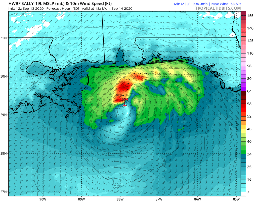
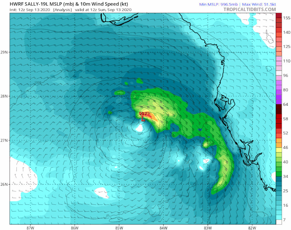
12Z HWRF looking similar to the 06Z out through 30 hours so far. Doesn’t look like it will be nearly as intense as the 00Z:
3 likes
Re: ATL: SALLY - Models
Yeah based on under performance thus far I’m leaning more toward Hwrf than hmon. It looks like conditions will just be too little too late.
Hmon going for a landfall in Pascagoula/Grand bay...guessing at this Point weaker Is going to mean more Harrison and Hancock and stronger means faster turn ne toward Jackson county
Hmon going for a landfall in Pascagoula/Grand bay...guessing at this Point weaker Is going to mean more Harrison and Hancock and stronger means faster turn ne toward Jackson county
0 likes
-
Hypercane_Kyle

- Category 5

- Posts: 3465
- Joined: Sat Mar 07, 2015 7:58 pm
- Location: Cape Canaveral, FL
Re: ATL: SALLY - Models
Chances of a significant hurricane (Cat 3+) have greatly reduced today.
5 likes
My posts are my own personal opinion, defer to the National Hurricane Center (NHC) and other NOAA products for decision making during hurricane season.
Re: ATL: SALLY - Models
To summarize 12 z we have:
GFs shifted East: tracks over the mouth and up the pearl river.
CMC shifted west, tracks over East Nola then pearl river.
Hmon: shifted East, Major hurricane landfall near ms/al border
Hwrf: shifted East, strong TS /cat 1 landfall Over the mouth of the pearl river
Have hard time seeing how NhC doesn’t shift track back to east side of Nola at 5 pm and extend hurricane warning to Mobile bay. Good news is even if it goes that Far East it seems hmon is solo in depicting a significant hurricane
0 likes
-
LowerAlabamaTider

- Tropical Storm
- Posts: 111
- Age: 66
- Joined: Thu Aug 20, 2020 1:08 pm
Re: ATL: SALLY - Models
I can imagine everyone at the NHC are scratching their heads right now. The lack of steering is something not even the models can settle in on. Not to mention everyone from NO to P’Cola along the coast.
2 likes
-
Sailingtime
- Tropical Low

- Posts: 38
- Joined: Thu Aug 29, 2019 7:02 pm
Re: ATL: SALLY - Models
Hypercane_Kyle wrote:Chances of a significant hurricane (Cat 3+) have greatly reduced today.
This is great news. No one needs the damage a major can do.
4 likes

Re: ATL: SALLY - Models
12 z euro straight over New Orleans from the west side of the mouth. Not much track change really. Just stronger than 0z
1 likes
Re: ATL: SALLY - Models
PTPatrick wrote:12 z euro straight over New Orleans from the west side of the mouth. Not much track change really. Just stronger than 0z
A day near/over the city - quality TS/Cat1. Possibly the strongest hit since Isaac (good TS). Other than him, you’d have to go back to Katrina for even Cat 1 winds. We’ve had a ton of fringe and close by stuff (slept through Ophelia which did bring TS winds) since Juan. Only Bill of centers that had weather that I can think of passed over since Florence ‘88. We will see. I got home from Pensacola and am looking to ride things out here. All preps are mostly done except a late nonessential food run. So it’s NFL today, here and models.
3 likes
Re: ATL: SALLY - Models
Oh for King Arabian, US Tropics or anyone who has the European rainfall totals from this run please show or describe. Looks like parts of MS could exceed 2’ with that Euro track
Last edited by Steve on Sun Sep 13, 2020 1:32 pm, edited 1 time in total.
0 likes
-
PTrackerLA

- Category 5
- Posts: 5281
- Age: 42
- Joined: Thu Oct 10, 2002 8:40 pm
- Location: Lafayette, LA

Re: ATL: SALLY - Models
Thanks Patrick. 16 inches of rain in the city with surge raising the lakes. Lol. That’s not good.
1 likes
Who is online
Users browsing this forum: No registered users and 13 guests