2020 Indicators: SST's / SAL / MSLP / Steering / Shear / Instability / Sat Images

This is the general tropical discussion area. Anyone can take their shot at predicting a storms path.

Moderator: S2k Moderators

Forum rules

The posts in this forum are NOT official forecasts and should not be used as such. They are just the opinion of the poster and may or may not be backed by sound meteorological data. They are NOT endorsed by any professional institution or STORM2K. For official information, please refer to products from the National Hurricane Center and National Weather Service.

Help Support Storm2K
Message
Author
ClarCari
Category 2
Category 2
Posts: 579
Joined: Thu Aug 13, 2020 11:02 am

Re: 2020 Indicators: SST's / SAL / MSLP / Steering / Shear / Instability / Sat Images

#3161 Postby ClarCari » Fri Sep 18, 2020 8:57 pm

Weather Dude wrote:
TheStormExpert wrote:
Weather Dude wrote:Yeah I didn't get to track that storm as I, uh, wasn't around yet :lol:

It struck South Florida on my 6th birthday. :lol:

Of course I wasn't in town for it, so the first hurricane I ever got to experience was Frances in 2004.

I have also never experienced a hurricane. But I did get hit by tropical depression Bill in 2015... oh and Erin in 2007 but I was 6 so I don't remember that one... Our ice storm was the big story that year and I do remember that one...

You sound almost like a San Antonian to me :)
That’s were I live and remember feeling Erin, Dolly 2008, and Harvey pretty bad for us here. San Antonio isn’t at all that far from the coast.

Also what were the signs that October was supposed to be active in 2017? I understand people woulda assumed the La Niña would contribute alot that year, but what did forecasters that year say?
I would imagine there are more reliable signs of an active October this year than there were in 2017.
0 likes   

User avatar
ElectricStorm
Category 5
Category 5
Posts: 5044
Age: 24
Joined: Tue Aug 13, 2019 11:23 pm
Location: Skiatook, OK / Norman, OK

Re: 2020 Indicators: SST's / SAL / MSLP / Steering / Shear / Instability / Sat Images

#3162 Postby ElectricStorm » Fri Sep 18, 2020 8:58 pm

:uarrow: Haha nope. A little North of Tulsa
1 likes   
B.S Meteorology, University of Oklahoma '25

Please refer to the NHC, NWS, or SPC for official information.

TheStormExpert

Re: 2020 Indicators: SST's / SAL / MSLP / Steering / Shear / Instability / Sat Images

#3163 Postby TheStormExpert » Fri Sep 18, 2020 9:24 pm

Weather Dude wrote:
TheStormExpert wrote:
Weather Dude wrote:Yeah I didn't get to track that storm as I, uh, wasn't around yet :lol:

It struck South Florida on my 6th birthday. :lol:

Of course I wasn't in town for it, so the first hurricane I ever got to experience was Frances in 2004.

I have also never experienced a hurricane. But I did get hit by tropical depression Bill in 2015... oh and Erin in 2007 but I was 6 so I don't remember that one... Our ice storm was the big story that year and I do remember that one...

The only legit hurricanes I've been through are Frances and Jeanne in 2004, and Wilma in 2005.
0 likes   

User avatar
aspen
Category 5
Category 5
Posts: 8818
Joined: Sat Oct 12, 2019 7:10 pm
Location: Connecticut, USA

Re: 2020 Indicators: SST's / SAL / MSLP / Steering / Shear / Instability / Sat Images

#3164 Postby aspen » Sat Sep 19, 2020 8:12 pm

Despite ACE seriously lagging behind named storms, I don’t think a >150 ACE total is in jeopardy.

2020’s total ACE will likely reach or surpass 100 by the time Teddy, Wilfred, and Beta are all done (maybe Paulette will come back to add some more). Let’s say we see a long-tracking Caribbean major in October like Wilma or Matthew that produces 30-40 ACE, two hurricanes that produce 10-15 ACE each, and then 25-40 ACE from everything else. That would be 175-210 ACE total by the end of the season, within the top 15 or even top 10 highest for any Atlantic hurricane season. Even closer to the lower end would still meet the definition of hyperactive and get close to many of the official ACE forecasts.
3 likes   
Irene '11 Sandy '12 Hermine '16 5/15/2018 Derecho Fay '20 Isaias '20 Elsa '21 Henri '21 Ida '21

I am only a meteorology enthusiast who knows a decent amount about tropical cyclones. Look to the professional mets, the NHC, or your local weather office for the best information.

TheStormExpert

Re: 2020 Indicators: SST's / SAL / MSLP / Steering / Shear / Instability / Sat Images

#3165 Postby TheStormExpert » Sat Sep 19, 2020 8:39 pm

My guess is ACE anywhere between 130-160 units depending on how the remaining 72 days of the season go.
1 likes   

UTSARoadrunner4
Category 1
Category 1
Posts: 250
Age: 28
Joined: Wed Aug 26, 2020 11:19 pm

Re: 2020 Indicators: SST's / SAL / MSLP / Steering / Shear / Instability / Sat Images

#3166 Postby UTSARoadrunner4 » Sun Sep 20, 2020 1:07 am

TheStormExpert wrote:
Weather Dude wrote:
TheStormExpert wrote:It struck South Florida on my 6th birthday. :lol:

Of course I wasn't in town for it, so the first hurricane I ever got to experience was Frances in 2004.

I have also never experienced a hurricane. But I did get hit by tropical depression Bill in 2015... oh and Erin in 2007 but I was 6 so I don't remember that one... Our ice storm was the big story that year and I do remember that one...

The only legit hurricanes I've been through are Frances and Jeanne in 2004, and Wilma in 2005.


Before I came to UTSA I went through 2001 Allison, 2003 Claudette, 2005 Rita (evacuation part only), 2007 Humberto, 2008 Edouard & Ike, and 2015 Bill. The only thing I've had to deal with in SA was a hailstorm, a scare from Harvey, random snow, and lots of dry heatwaves. Kinda miss the coast now...
0 likes   

User avatar
cycloneye
Admin
Admin
Posts: 145303
Age: 68
Joined: Thu Oct 10, 2002 10:54 am
Location: San Juan, Puerto Rico

Re: 2020 Indicators: SST's / SAL / MSLP / Steering / Shear / Instability / Sat Images

#3167 Postby cycloneye » Sun Sep 20, 2020 8:24 am

0 likes   
Visit the Caribbean-Central America Weather Thread where you can find at first post web cams,radars
and observations from Caribbean basin members Click Here

TheStormExpert

Re: 2020 Indicators: SST's / SAL / MSLP / Steering / Shear / Instability / Sat Images

#3168 Postby TheStormExpert » Sun Sep 20, 2020 8:39 am

Indications are that things will pick up once again in early October as the GFS and its ensembles show Western Caribbean mischief then.
3 likes   

User avatar
aspen
Category 5
Category 5
Posts: 8818
Joined: Sat Oct 12, 2019 7:10 pm
Location: Connecticut, USA

Re: 2020 Indicators: SST's / SAL / MSLP / Steering / Shear / Instability / Sat Images

#3169 Postby aspen » Sun Sep 20, 2020 2:11 pm

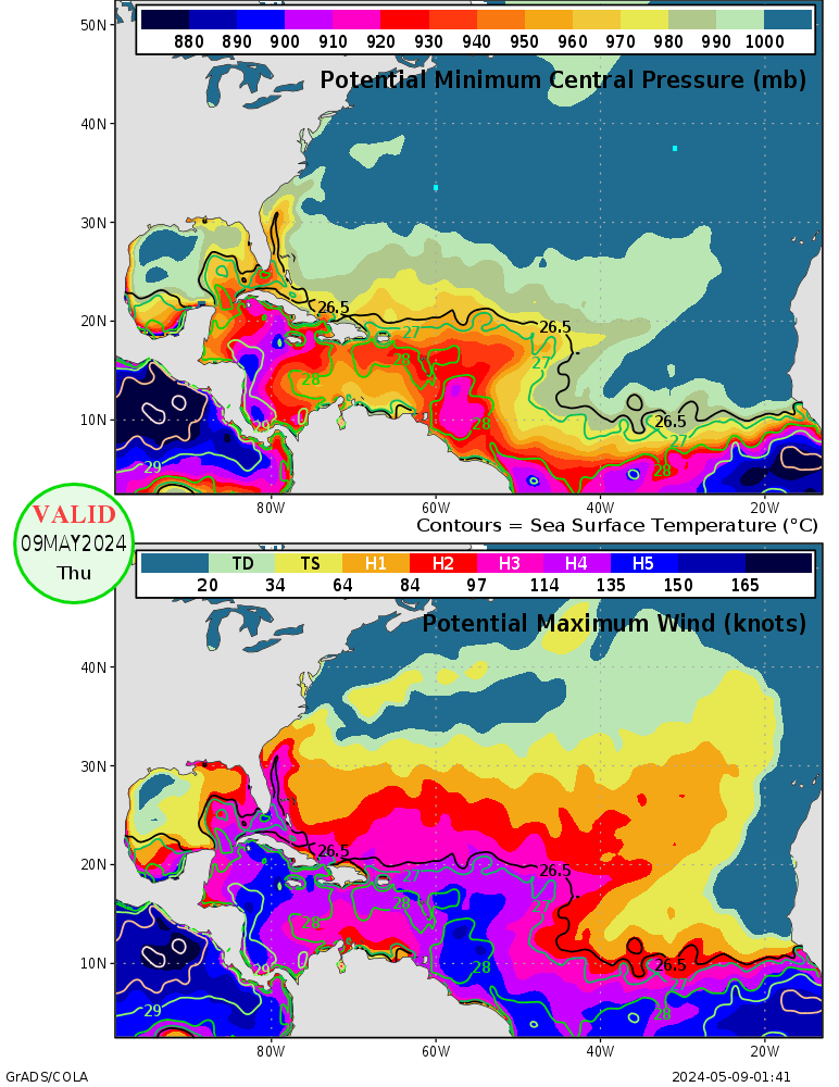
We definitely need to keep a very close eye on the Caribbean come October or very late September at the earliest. Things could go crazy once the suppressive CCKW moves out. SSTs/OHC are ridiculously high in the Caribbean, as indicated by the MPI map. The entire region could support a sub-900 mbar Cat 5 at the most.
Image

I also went back through most of the active seasons, and the majority of above-average to hyperactive Atlantic hurricane seasons had at least one major between September 20th and November 30th: 1893, 1933, 1950, 1954, 1961, 1995, 1996, 1998, 2001, 2003, 2005, 2008, 2011, 2012, 2016, 2017, and 2018. Some below-average/normal years like 2002 and 2015 also had one too. Out of the top 10 ACE producing seasons, only 2004 had no major hurricane form in that time frame, and out of the seasons I listed here, most had a major form in the Caribbean or Gulf (1893, 1933, 1954, 1961, 1995, 1996, 1998,1999, 2000, 2001, 2002, 2008, 2011, 2012, 2016, 2018). A few seasons also had very late season Cape Verde or open Atlantic majors like 1893's Hurricane Nine, Jig '50, Frances '61, Isidore '96, Issac '00, Kate '03, Joaquin '15, Nicole '16, and Ophelia '17. With 2020's ease at forming storms, a favorable Caribbean, and the potential for an active October, at least one major in that region and time frame is highly likely just looking at the frequency of such storms. I won't rule out a major off of the SEUS coast because of that untapped pocket of 29-31C SSTs northeast of the Bahamas.
7 likes   
Irene '11 Sandy '12 Hermine '16 5/15/2018 Derecho Fay '20 Isaias '20 Elsa '21 Henri '21 Ida '21

I am only a meteorology enthusiast who knows a decent amount about tropical cyclones. Look to the professional mets, the NHC, or your local weather office for the best information.

User avatar
Hammy
Category 5
Category 5
Posts: 5849
Age: 41
Joined: Fri May 25, 2012 5:25 pm
Contact:

Re: 2020 Indicators: SST's / SAL / MSLP / Steering / Shear / Instability / Sat Images

#3170 Postby Hammy » Sun Sep 20, 2020 3:08 pm

aspen wrote: Out of the top 10 ACE producing seasons, only 2004 had no major hurricane form in that time frame


Worth noting that 2004 had a major during that time that formed on Sep 19.
1 likes   
The above post is not official and should not be used as such. It is the opinion of the poster and may or may not be backed by sound meteorological data. It is not endorsed by any professional institution or storm2k.org. For official information, please refer to the NHC and NWS products.

User avatar
cycloneye
Admin
Admin
Posts: 145303
Age: 68
Joined: Thu Oct 10, 2002 10:54 am
Location: San Juan, Puerto Rico

Re: 2020 Indicators: SST's / SAL / MSLP / Steering / Shear / Instability / Sat Images

#3171 Postby cycloneye » Sun Sep 20, 2020 3:09 pm

aspen wrote:We definitely need to keep a very close eye on the Caribbean come October or very late September at the earliest. Things could go crazy once the suppressive CCKW moves out. SSTs/OHC are ridiculously high in the Caribbean, as indicated by the MPI map. The entire region could support a sub-900 mbar Cat 5 at the most.
http://wxmaps.org/pix/atlpot.png

I also went back through most of the active seasons, and the majority of above-average to hyperactive Atlantic hurricane seasons had at least one major between September 20th and November 30th: 1893, 1933, 1950, 1954, 1961, 1995, 1996, 1998, 2001, 2003, 2005, 2008, 2011, 2012, 2016, 2017, and 2018. Some below-average/normal years like 2002 and 2015 also had one too. Out of the top 10 ACE producing seasons, only 2004 had no major hurricane form in that time frame, and out of the seasons I listed here, most had a major form in the Caribbean or Gulf (1893, 1933, 1954, 1961, 1995, 1996, 1998,1999, 2000, 2001, 2002, 2008, 2011, 2012, 2016, 2018). A few seasons also had very late season Cape Verde or open Atlantic majors like 1893's Hurricane Nine, Jig '50, Frances '61, Isidore '96, Issac '00, Kate '03, Joaquin '15, Nicole '16, and Ophelia '17. With 2020's ease at forming storms, a favorable Caribbean, and the potential for an active October, at least one major in that region and time frame is highly likely just looking at the frequency of such storms. I won't rule out a major off of the SEUS coast because of that untapped pocket of 29-31C SSTs northeast of the Bahamas.


Something like Joaquin 2015 right?

Image
0 likes   
Visit the Caribbean-Central America Weather Thread where you can find at first post web cams,radars
and observations from Caribbean basin members Click Here

User avatar
aspen
Category 5
Category 5
Posts: 8818
Joined: Sat Oct 12, 2019 7:10 pm
Location: Connecticut, USA

Re: 2020 Indicators: SST's / SAL / MSLP / Steering / Shear / Instability / Sat Images

#3172 Postby aspen » Sun Sep 20, 2020 3:31 pm

cycloneye wrote:
aspen wrote:We definitely need to keep a very close eye on the Caribbean come October or very late September at the earliest. Things could go crazy once the suppressive CCKW moves out. SSTs/OHC are ridiculously high in the Caribbean, as indicated by the MPI map. The entire region could support a sub-900 mbar Cat 5 at the most.
http://wxmaps.org/pix/atlpot.png

I also went back through most of the active seasons, and the majority of above-average to hyperactive Atlantic hurricane seasons had at least one major between September 20th and November 30th: 1893, 1933, 1950, 1954, 1961, 1995, 1996, 1998, 2001, 2003, 2005, 2008, 2011, 2012, 2016, 2017, and 2018. Some below-average/normal years like 2002 and 2015 also had one too. Out of the top 10 ACE producing seasons, only 2004 had no major hurricane form in that time frame, and out of the seasons I listed here, most had a major form in the Caribbean or Gulf (1893, 1933, 1954, 1961, 1995, 1996, 1998,1999, 2000, 2001, 2002, 2008, 2011, 2012, 2016, 2018). A few seasons also had very late season Cape Verde or open Atlantic majors like 1893's Hurricane Nine, Jig '50, Frances '61, Isidore '96, Issac '00, Kate '03, Joaquin '15, Nicole '16, and Ophelia '17. With 2020's ease at forming storms, a favorable Caribbean, and the potential for an active October, at least one major in that region and time frame is highly likely just looking at the frequency of such storms. I won't rule out a major off of the SEUS coast because of that untapped pocket of 29-31C SSTs northeast of the Bahamas.


Something like Joaquin 2015 right?

https://i.imgur.com/SRbPDqc.png

Yeah, something like Joaquin could be possible. Didn’t it form from non-tropical origins?
1 likes   
Irene '11 Sandy '12 Hermine '16 5/15/2018 Derecho Fay '20 Isaias '20 Elsa '21 Henri '21 Ida '21

I am only a meteorology enthusiast who knows a decent amount about tropical cyclones. Look to the professional mets, the NHC, or your local weather office for the best information.

User avatar
cycloneye
Admin
Admin
Posts: 145303
Age: 68
Joined: Thu Oct 10, 2002 10:54 am
Location: San Juan, Puerto Rico

Re: 2020 Indicators: SST's / SAL / MSLP / Steering / Shear / Instability / Sat Images

#3173 Postby cycloneye » Sun Sep 20, 2020 3:45 pm

aspen wrote:
cycloneye wrote:
aspen wrote:We definitely need to keep a very close eye on the Caribbean come October or very late September at the earliest. Things could go crazy once the suppressive CCKW moves out. SSTs/OHC are ridiculously high in the Caribbean, as indicated by the MPI map. The entire region could support a sub-900 mbar Cat 5 at the most.
http://wxmaps.org/pix/atlpot.png

I also went back through most of the active seasons, and the majority of above-average to hyperactive Atlantic hurricane seasons had at least one major between September 20th and November 30th: 1893, 1933, 1950, 1954, 1961, 1995, 1996, 1998, 2001, 2003, 2005, 2008, 2011, 2012, 2016, 2017, and 2018. Some below-average/normal years like 2002 and 2015 also had one too. Out of the top 10 ACE producing seasons, only 2004 had no major hurricane form in that time frame, and out of the seasons I listed here, most had a major form in the Caribbean or Gulf (1893, 1933, 1954, 1961, 1995, 1996, 1998,1999, 2000, 2001, 2002, 2008, 2011, 2012, 2016, 2018). A few seasons also had very late season Cape Verde or open Atlantic majors like 1893's Hurricane Nine, Jig '50, Frances '61, Isidore '96, Issac '00, Kate '03, Joaquin '15, Nicole '16, and Ophelia '17. With 2020's ease at forming storms, a favorable Caribbean, and the potential for an active October, at least one major in that region and time frame is highly likely just looking at the frequency of such storms. I won't rule out a major off of the SEUS coast because of that untapped pocket of 29-31C SSTs northeast of the Bahamas.


Something like Joaquin 2015 right?

https://i.imgur.com/SRbPDqc.png

Yeah, something like Joaquin could be possible. Didn’t it form from non-tropical origins?


Yes. Here is the origin from report.

Joaquin’s formation is notable in that the cyclone did not have tropical origins, which is
rare for a major hurricane. The incipient disturbance can be traced back to 8 September when a
weak mid- to upper-tropospheric low developed over the eastern Atlantic Ocean west-southwest
of the Canary Islands. A piece of this system moved westward across the Atlantic for over a
week, and amplified into a more significant mid- to upper-level low over the central Atlantic
northeast of the Leeward Islands on 19 September. This feature continued to move westward for
several more days and gradually acquired more vertical depth, with a stronger perturbation
forming in the lower troposphere late on 25 September
0 likes   
Visit the Caribbean-Central America Weather Thread where you can find at first post web cams,radars
and observations from Caribbean basin members Click Here

User avatar
aspen
Category 5
Category 5
Posts: 8818
Joined: Sat Oct 12, 2019 7:10 pm
Location: Connecticut, USA

Re: 2020 Indicators: SST's / SAL / MSLP / Steering / Shear / Instability / Sat Images

#3174 Postby aspen » Sun Sep 20, 2020 8:58 pm

Does someone have storm-by-storm ACE breakdowns for the 1961, 1995, 1999, 2000, 2001, 2008, 2015, and 2016 seasons? I want to see how much late-season Caribbean activity impacted the final ACE total for all of those years.
0 likes   
Irene '11 Sandy '12 Hermine '16 5/15/2018 Derecho Fay '20 Isaias '20 Elsa '21 Henri '21 Ida '21

I am only a meteorology enthusiast who knows a decent amount about tropical cyclones. Look to the professional mets, the NHC, or your local weather office for the best information.

Chris90
Category 2
Category 2
Posts: 646
Age: 35
Joined: Thu Jun 01, 2017 9:36 pm

Re: 2020 Indicators: SST's / SAL / MSLP / Steering / Shear / Instability / Sat Images

#3175 Postby Chris90 » Sun Sep 20, 2020 9:33 pm

aspen wrote:Does someone have storm-by-storm ACE breakdowns for the 1961, 1995, 1999, 2000, 2001, 2008, 2015, and 2016 seasons? I want to see how much late-season Caribbean activity impacted the final ACE total for all of those years.


2016: https://en.m.wikipedia.org/wiki/Talk:20 ... ne_Reports)
2015: https://en.m.wikipedia.org/wiki/Talk:20 ... ne_Reports)
2008: https://en.m.wikipedia.org/wiki/Talk:20 ... Track_(TCR)

That’s all I have though, I don’t have the other years, sorry.
2 likes   
Solar Aquarian
Lunar Cancerian
:uarrow: Sagittarian

User avatar
ElectricStorm
Category 5
Category 5
Posts: 5044
Age: 24
Joined: Tue Aug 13, 2019 11:23 pm
Location: Skiatook, OK / Norman, OK

Re: 2020 Indicators: SST's / SAL / MSLP / Steering / Shear / Instability / Sat Images

#3176 Postby ElectricStorm » Sun Sep 20, 2020 9:50 pm

aspen wrote:We definitely need to keep a very close eye on the Caribbean come October or very late September at the earliest. Things could go crazy once the suppressive CCKW moves out. SSTs/OHC are ridiculously high in the Caribbean, as indicated by the MPI map. The entire region could support a sub-900 mbar Cat 5 at the most.
http://wxmaps.org/pix/atlpot.png

I also went back through most of the active seasons, and the majority of above-average to hyperactive Atlantic hurricane seasons had at least one major between September 20th and November 30th: 1893, 1933, 1950, 1954, 1961, 1995, 1996, 1998, 2001, 2003, 2005, 2008, 2011, 2012, 2016, 2017, and 2018. Some below-average/normal years like 2002 and 2015 also had one too. Out of the top 10 ACE producing seasons, only 2004 had no major hurricane form in that time frame, and out of the seasons I listed here, most had a major form in the Caribbean or Gulf (1893, 1933, 1954, 1961, 1995, 1996, 1998,1999, 2000, 2001, 2002, 2008, 2011, 2012, 2016, 2018). A few seasons also had very late season Cape Verde or open Atlantic majors like 1893's Hurricane Nine, Jig '50, Frances '61, Isidore '96, Issac '00, Kate '03, Joaquin '15, Nicole '16, and Ophelia '17. With 2020's ease at forming storms, a favorable Caribbean, and the potential for an active October, at least one major in that region and time frame is highly likely just looking at the frequency of such storms. I won't rule out a major off of the SEUS coast because of that untapped pocket of 29-31C SSTs northeast of the Bahamas.

To add to the first part of your post, here is the current OHC for 2020:
Image
And here is the OHC for this date in 2005, about a month before Wilma:
Image
I know Wilma didn't occur for another month but we are actually very similar to 2005 right now in the Western Caribbean The dark red on the 2005 map represents OHC values at about 150 kJ cm^-2 compared to 2020's map, where the darkest red is about 175 kJ cm^-2. So although at first glance it appears that 2005 had much more OHC than 2020, they are actually relatively similar. I know a few of the models are hinting at something trying to develop over there the first week of October. If something does indeed get going over there and has good enough conditions to fully be able to take advantage of that OHC and MPI, it could certainly explode into a Wilma-like storm. Obviously it would have to have absolutely perfect conditions, but it is something to think about.
EDIT: Here is the current OHC map with the same scale as the 2005 map as a direct comparison:
Image
Last edited by ElectricStorm on Sun Sep 20, 2020 10:07 pm, edited 1 time in total.
4 likes   
B.S Meteorology, University of Oklahoma '25

Please refer to the NHC, NWS, or SPC for official information.

TheStormExpert

Re: 2020 Indicators: SST's / SAL / MSLP / Steering / Shear / Instability / Sat Images

#3177 Postby TheStormExpert » Sun Sep 20, 2020 9:50 pm

I think it’s safe to say the short-lived Cape Verde season is over now that Wilfred degenerated.

Image
0 likes   

User avatar
toad strangler
S2K Supporter
S2K Supporter
Posts: 4543
Joined: Sun Jul 28, 2013 3:09 pm
Location: Earth
Contact:

Re: 2020 Indicators: SST's / SAL / MSLP / Steering / Shear / Instability / Sat Images

#3178 Postby toad strangler » Sun Sep 20, 2020 10:12 pm

TheStormExpert wrote:I think it’s safe to say the short-lived Cape Verde season is over now that Wilfred degenerated.

https://i.imgur.com/5I15wUo_d.webp?maxwidth=640&shape=thumb&fidelity=medium.jpg


#dissipated
1 likes   

TheStormExpert

Re: 2020 Indicators: SST's / SAL / MSLP / Steering / Shear / Instability / Sat Images

#3179 Postby TheStormExpert » Sun Sep 20, 2020 10:14 pm

toad strangler wrote:
TheStormExpert wrote:I think it’s safe to say the short-lived Cape Verde season is over now that Wilfred degenerated.

https://i.imgur.com/5I15wUo_d.webp?maxwidth=640&shape=thumb&fidelity=medium.jpg


#dissipated

Same thing basically.
0 likes   

User avatar
Hammy
Category 5
Category 5
Posts: 5849
Age: 41
Joined: Fri May 25, 2012 5:25 pm
Contact:

Re: 2020 Indicators: SST's / SAL / MSLP / Steering / Shear / Instability / Sat Images

#3180 Postby Hammy » Sun Sep 20, 2020 11:57 pm

TheStormExpert wrote:I think it’s safe to say the short-lived Cape Verde season is over now that Wilfred degenerated.

https://i.imgur.com/5I15wUo_d.webp?maxwidth=640&shape=thumb&fidelity=medium.jpg


CFS says otherwise, still shows storms in the MDR into mid-October.
5 likes   
The above post is not official and should not be used as such. It is the opinion of the poster and may or may not be backed by sound meteorological data. It is not endorsed by any professional institution or storm2k.org. For official information, please refer to the NHC and NWS products.


Return to “Talkin' Tropics”

Who is online

Users browsing this forum: BobHarlem, Noots and 48 guests