2020 Indicators: SST's / SAL / MSLP / Steering / Shear / Instability / Sat Images

This is the general tropical discussion area. Anyone can take their shot at predicting a storms path.

Moderator: S2k Moderators

Forum rules

The posts in this forum are NOT official forecasts and should not be used as such. They are just the opinion of the poster and may or may not be backed by sound meteorological data. They are NOT endorsed by any professional institution or STORM2K. For official information, please refer to products from the National Hurricane Center and National Weather Service.

Help Support Storm2K
Message
Author
User avatar
chaser1
S2K Supporter
S2K Supporter
Posts: 5464
Age: 64
Joined: Sat Oct 15, 2005 5:59 pm
Location: Longwood, Fl

Re: 2020 Indicators: SST's / SAL / MSLP / Steering / Shear / Instability / Sat Images

#3181 Postby chaser1 » Mon Sep 21, 2020 12:48 am

Weather Dude wrote:
aspen wrote:We definitely need to keep a very close eye on the Caribbean come October or very late September at the earliest. Things could go crazy once the suppressive CCKW moves out. SSTs/OHC are ridiculously high in the Caribbean, as indicated by the MPI map. The entire region could support a sub-900 mbar Cat 5 at the most.
http://wxmaps.org/pix/atlpot.png

I also went back through most of the active seasons, and the majority of above-average to hyperactive Atlantic hurricane seasons had at least one major between September 20th and November 30th: 1893, 1933, 1950, 1954, 1961, 1995, 1996, 1998, 2001, 2003, 2005, 2008, 2011, 2012, 2016, 2017, and 2018. Some below-average/normal years like 2002 and 2015 also had one too. Out of the top 10 ACE producing seasons, only 2004 had no major hurricane form in that time frame, and out of the seasons I listed here, most had a major form in the Caribbean or Gulf (1893, 1933, 1954, 1961, 1995, 1996, 1998,1999, 2000, 2001, 2002, 2008, 2011, 2012, 2016, 2018). A few seasons also had very late season Cape Verde or open Atlantic majors like 1893's Hurricane Nine, Jig '50, Frances '61, Isidore '96, Issac '00, Kate '03, Joaquin '15, Nicole '16, and Ophelia '17. With 2020's ease at forming storms, a favorable Caribbean, and the potential for an active October, at least one major in that region and time frame is highly likely just looking at the frequency of such storms. I won't rule out a major off of the SEUS coast because of that untapped pocket of 29-31C SSTs northeast of the Bahamas.

To add to the first part of your post, here is the current OHC for 2020:
https://i.imgur.com/lKfYkYr.gif
And here is the OHC for this date in 2005, about a month before Wilma:
https://i.imgur.com/fOPXr1s.gif
I know Wilma didn't occur for another month but we are actually very similar to 2005 right now in the Western Caribbean The dark red on the 2005 map represents OHC values at about 150 kJ cm^-2 compared to 2020's map, where the darkest red is about 175 kJ cm^-2. So although at first glance it appears that 2005 had much more OHC than 2020, they are actually relatively similar. I know a few of the models are hinting at something trying to develop over there the first week of October. If something does indeed get going over there and has good enough conditions to fully be able to take advantage of that OHC and MPI, it could certainly explode into a Wilma-like storm. Obviously it would have to have absolutely perfect conditions, but it is something to think about.
EDIT: Here is the current OHC map with the same scale as the 2005 map as a direct comparison:
https://i.imgur.com/KkCH7kO.gif


To put an exclamation mark on the above, it's important to keep in mind a factor potentially more foreboding then the OHC itself. As you inferred, "if" having absolute perfect conditions the result of very warm (and deep) SST's further enhances the chance of a major 'cane to develop. We've seen many years where in spite of warm SST's and low surface pressures, upper level conditions would decapitate anything crossing 20N. As La Nina conditions slowly progress, upper level conditions over the Caribbean are less apt to be impacted by unfavorable westerly upper level shear. One or two majors may easily develop in the days or weeks to come. More worrisome to me then whether a storm might develop & peak at Cat 5, is simply the increased risk of ANY W. Caribbean hurricane that ends up tracking north.
Why? Because this year, the Enterprise deflector shields might really be down and there may not be a darn thing that Scotty can do to raise 'em #photontorpedo
1 likes   
Andy D

(For official information, please refer to the NHC and NWS products.)

User avatar
Steve
S2K Supporter
S2K Supporter
Posts: 9621
Joined: Sat Apr 05, 2003 11:41 pm
Location: Not a state-caster

Re: 2020 Indicators: SST's / SAL / MSLP / Steering / Shear / Instability / Sat Images

#3182 Postby Steve » Mon Sep 21, 2020 10:42 am

We'll cross 100 ACE today and probably the "average" 105.6 by tomorrow if not today. We checked that box.
7 likes   

LarryWx
S2K Supporter
S2K Supporter
Posts: 6305
Joined: Sun Sep 07, 2003 2:04 pm
Location: GA

Re: 2020 Indicators: SST's / SAL / MSLP / Steering / Shear / Instability / Sat Images

#3183 Postby LarryWx » Mon Sep 21, 2020 4:13 pm

FL has had ~12 major Hs make actual landfall in October since 1851 or about one every 14 seasons (7% of the seasons..call this the "normal" chance):

2018 (Michael), 2005 (Wilma), 1995 (Opal), 1964 (Isbell). 1950 (King), 1948 (#9 I think at Key West though this may be debatable), 1941 (#5), 1921, 1909 (#11 I think in the Keys though this may be debatable), 1906 (#8), 1877 (#4), 1873 (#5)

So, on average 1 of every 14 Octobers has had a major H hit FL since 1851. However, during weak to moderate Nina (like we have now) following weak to moderate El Nino (like we had last fall/winter), those 10 analogs included 3 MH landfalls on FL or 30% of the analog seasons vs 7% of all seasons or over 4 times as frequent. I realize caution is advised in coming up with the chance from a sample size of only 10. But, also keep in mind that much of the W Caribbean is untouched in recent weeks with very high OHC. In addition, the GFS and para-GFS suites have been showing Oct threats on repeated runs. When considering all 3 of these things, I'm hypothesizing that the chance this October of a major landfalling H on FL quite possibly really is at least 4 times the normal chance or close to a 1 in 3 chance. That's pretty scary if you ask me. :eek:

*************Edit: I left off the 1921 Tampa major hit. I just changed this writeup as a result since I now count 12 major Oct FL hits since 1851. That is still 7% of seasons. So, most of this post was left as I had it.
9 likes   
Personal Forecast Disclaimer:
The posts in this forum are NOT official forecasts and should not be used as such. They are just the opinion of the poster and may or may not be backed by sound meteorological data. They are NOT endorsed by any professional institution or storm2k.org. For official information, please refer to the NHC and NWS products.

User avatar
chaser1
S2K Supporter
S2K Supporter
Posts: 5464
Age: 64
Joined: Sat Oct 15, 2005 5:59 pm
Location: Longwood, Fl

Re: 2020 Indicators: SST's / SAL / MSLP / Steering / Shear / Instability / Sat Images

#3184 Postby chaser1 » Mon Sep 21, 2020 7:19 pm

LarryWx wrote:FL has had ~12 major Hs make actual landfall in October since 1851 or about one every 14 seasons (7% of the seasons..call this the "normal" chance):

2018 (Michael), 2005 (Wilma), 1995 (Opal), 1964 (Isbell). 1950 (King), 1948 (#9 I think at Key West though this may be debatable), 1941 (#5), 1921, 1909 (#11 I think in the Keys though this may be debatable), 1906 (#8), 1877 (#4), 1873 (#5)

So, on average 1 of every 14 Octobers has had a major H hit FL since 1851. However, during weak to moderate Nina (like we have now) following weak to moderate El Nino (like we had last fall/winter), those 10 analogs included 3 MH landfalls on FL or 30% of the analog seasons vs 7% of all seasons or over 4 times as frequent. I realize caution is advised in coming up with the chance from a sample size of only 10. But, also keep in mind that much of the W Caribbean is untouched in recent weeks with very high OHC. In addition, the GFS and para-GFS suites have been showing Oct threats on repeated runs. When considering all 3 of these things, I'm hypothesizing that the chance this October of a major landfalling H on FL quite possibly really is at least 4 times the normal chance or close to a 1 in 3 chance. That's pretty scary if you ask me. :eek:

*************Edit: I left off the 1921 Tampa major hit. I just changed this writeup as a result since I now count 12 major Oct FL hits since 1851. That is still 7% of seasons. So, most of this post was left as I had it.


Larry, not to make you work more then you have I'm curious if or how much those La Nina October percentages would change if the same review took into account all hurricane landfalls. Had you considered reviewing that larger subset?
0 likes   
Andy D

(For official information, please refer to the NHC and NWS products.)

LarryWx
S2K Supporter
S2K Supporter
Posts: 6305
Joined: Sun Sep 07, 2003 2:04 pm
Location: GA

Re: 2020 Indicators: SST's / SAL / MSLP / Steering / Shear / Instability / Sat Images

#3185 Postby LarryWx » Mon Sep 21, 2020 7:33 pm

chaser1 wrote:
LarryWx wrote:FL has had ~12 major Hs make actual landfall in October since 1851 or about one every 14 seasons (7% of the seasons..call this the "normal" chance):

2018 (Michael), 2005 (Wilma), 1995 (Opal), 1964 (Isbell). 1950 (King), 1948 (#9 I think at Key West though this may be debatable), 1941 (#5), 1921, 1909 (#11 I think in the Keys though this may be debatable), 1906 (#8), 1877 (#4), 1873 (#5)

So, on average 1 of every 14 Octobers has had a major H hit FL since 1851. However, during weak to moderate Nina (like we have now) following weak to moderate El Nino (like we had last fall/winter), those 10 analogs included 3 MH landfalls on FL or 30% of the analog seasons vs 7% of all seasons or over 4 times as frequent. I realize caution is advised in coming up with the chance from a sample size of only 10. But, also keep in mind that much of the W Caribbean is untouched in recent weeks with very high OHC. In addition, the GFS and para-GFS suites have been showing Oct threats on repeated runs. When considering all 3 of these things, I'm hypothesizing that the chance this October of a major landfalling H on FL quite possibly really is at least 4 times the normal chance or close to a 1 in 3 chance. That's pretty scary if you ask me. :eek:

*************Edit: I left off the 1921 Tampa major hit. I just changed this writeup as a result since I now count 12 major Oct FL hits since 1851. That is still 7% of seasons. So, most of this post was left as I had it.


Larry, not to make you work more then you have I'm curious if or how much those La Nina October percentages would change if the same review took into account all hurricane landfalls. Had you considered reviewing that larger subset?


For my 10 La Nina analogs, 4 of the 10 had a FL Oct H landfall, with 3 of those 4 H being majors. I didn't count all La Nina.
2 likes   
Personal Forecast Disclaimer:
The posts in this forum are NOT official forecasts and should not be used as such. They are just the opinion of the poster and may or may not be backed by sound meteorological data. They are NOT endorsed by any professional institution or storm2k.org. For official information, please refer to the NHC and NWS products.

Frank2
Category 5
Category 5
Posts: 4061
Joined: Mon Jul 25, 2005 12:47 pm

Re: 2020 Indicators: SST's / SAL / MSLP / Steering / Shear / Instability / Sat Images

#3186 Postby Frank2 » Tue Sep 22, 2020 7:42 am

Wow, looking at this morning's Atlantic wide view from 30 N and southward, you'd think it was January: https://www.star.nesdis.noaa.gov/GOES/s ... &length=24
0 likes   

TheStormExpert

Re: 2020 Indicators: SST's / SAL / MSLP / Steering / Shear / Instability / Sat Images

#3187 Postby TheStormExpert » Tue Sep 22, 2020 12:04 pm

Frank2 wrote:Wow, looking at this morning's Atlantic wide view from 30 N and southward, you'd think it was January: https://www.star.nesdis.noaa.gov/GOES/s ... &length=24

A cold front passing through Cuba in late-September!? That’s something you never see. :eek:

But yeah 2020 has been a strange year including weather-wise. Still can’t let our guard down here in South Florida as October is notorious for bringing us some tricks rather than treats. :wink:
0 likes   

User avatar
AnnularCane
S2K Supporter
S2K Supporter
Posts: 2862
Joined: Thu Jun 08, 2006 9:18 am
Location: Wytheville, VA

Re: 2020 Indicators: SST's / SAL / MSLP / Steering / Shear / Instability / Sat Images

#3188 Postby AnnularCane » Tue Sep 22, 2020 12:30 pm

That "cold front" isn't part of Teddy?
0 likes   

User avatar
CyclonicFury
Category 5
Category 5
Posts: 2025
Age: 26
Joined: Sun Jul 02, 2017 12:32 pm
Location: NC
Contact:

Re: 2020 Indicators: SST's / SAL / MSLP / Steering / Shear / Instability / Sat Images

#3189 Postby CyclonicFury » Tue Sep 22, 2020 2:26 pm

It's looking likely we will see a break in activity, perhaps short, after Beta, Teddy and Paulette all dissipate (which should happen soon). Such an event would not be surprising as it is common for the Atlantic to calm down after a significant burst in activity. Although the global models have struggled with TC genesis this year, the suppressed Kelvin Wave is likely going to slow down the west African Monsoon and increase shear over the deep tropics, so the short-term lack of activity on the models is believable. I personally don't think we'll see Gamma until October, but we could have several named storms form during October.

2017 had a similar lull in activity - after Maria was named on September 16, no new TCs developed until Nate on October 4. 2012 had a lengthy lull in new formations after Nadine formed on September 11, and Oscar did not form until October 4.

I would caution against declaring the season over though. The Caribbean always bears watching during a La Nina year in October-November, especially with the anomalously warm SST there this year. However, that does not always result in a strong Caribbean storm during October - 2017 is another example of this.
11 likes   
NCSU B.S. in Meteorology Class of 2021. Tropical weather blogger at http://www.cyclonicfury.com. My forecasts and thoughts are NOT official, for official forecasts please consult the National Hurricane Center.

psyclone
S2K Supporter
S2K Supporter
Posts: 4762
Joined: Wed Aug 24, 2005 9:04 pm
Location: palm harbor fl

Re: 2020 Indicators: SST's / SAL / MSLP / Steering / Shear / Instability / Sat Images

#3190 Postby psyclone » Tue Sep 22, 2020 2:56 pm

It was a swing and a miss in 2017 for late activity. Nate had a chance and showed insanely deep convection but was just moving too fast to organize. given better circumstances Nate could have easily been another major. We have the same shot this year. it's definitely high risk but we still have good chances to luck out. In the near term we do get a break...finally. But more stuff is going to happen and it could be significant. I wouldn't be surprised to see November activity in the far southwest caribbean that moves into Nicaragua or Costa Rica.
2 likes   

User avatar
chaser1
S2K Supporter
S2K Supporter
Posts: 5464
Age: 64
Joined: Sat Oct 15, 2005 5:59 pm
Location: Longwood, Fl

Re: 2020 Indicators: SST's / SAL / MSLP / Steering / Shear / Instability / Sat Images

#3191 Postby chaser1 » Tue Sep 22, 2020 4:33 pm

CyclonicFury wrote:It's looking likely we will see a break in activity, perhaps short, after Beta, Teddy and Paulette all dissipate (which should happen soon). Such an event would not be surprising as it is common for the Atlantic to calm down after a significant burst in activity. Although the global models have struggled with TC genesis this year, the suppressed Kelvin Wave is likely going to slow down the west African Monsoon and increase shear over the deep tropics, so the short-term lack of activity on the models is believable. I personally don't think we'll see Gamma until October, but we could have several named storms form during October.

2017 had a similar lull in activity - after Maria was named on September 16, no new TCs developed until Nate on October 4. 2012 had a lengthy lull in new formations after Nadine formed on September 11, and Oscar did not form until October 4.

I would caution against declaring the season over though. The Caribbean always bears watching during a La Nina year in October-November, especially with the anomalously warm SST there this year. However, that does not always result in a strong Caribbean storm during October - 2017 is another example of this.


Got a (GFS) update from Gamma. She was hinting at visiting S. Florida first week of October to bake cookies. The convection oven will likely be functional then. I'm personally concerned that she'll end up making a mess though.
7 likes   
Andy D

(For official information, please refer to the NHC and NWS products.)

MarioProtVI
Category 4
Category 4
Posts: 935
Age: 24
Joined: Sun Sep 29, 2019 7:33 pm
Location: New Jersey

Re: 2020 Indicators: SST's / SAL / MSLP / Steering / Shear / Instability / Sat Images

#3192 Postby MarioProtVI » Tue Sep 22, 2020 10:10 pm

For the first time in god knows how long, there are no active tropical cyclones or areas of interests. What a ride! :double: Finally we’ll get the lull that I think everyone here and at the NHC have been craving for so long (Atlantic wise for them...Lowell in the EPac trying to stay after hours :lol: :lol:) Enjoy while it lasts, as things are looking like they will cook back up in early October according to models in the Western Caribbean, which could be a very bad region this year..
1 likes   

User avatar
Hammy
Category 5
Category 5
Posts: 5849
Age: 41
Joined: Fri May 25, 2012 5:25 pm
Contact:

Re: 2020 Indicators: SST's / SAL / MSLP / Steering / Shear / Instability / Sat Images

#3193 Postby Hammy » Tue Sep 22, 2020 10:11 pm

Three storms becoming post-tropical at once, everything slowing down just as quick as it started up :lol:

Image
6 likes   
The above post is not official and should not be used as such. It is the opinion of the poster and may or may not be backed by sound meteorological data. It is not endorsed by any professional institution or storm2k.org. For official information, please refer to the NHC and NWS products.

User avatar
ElectricStorm
Category 5
Category 5
Posts: 5044
Age: 24
Joined: Tue Aug 13, 2019 11:23 pm
Location: Skiatook, OK / Norman, OK

Re: 2020 Indicators: SST's / SAL / MSLP / Steering / Shear / Instability / Sat Images

#3194 Postby ElectricStorm » Tue Sep 22, 2020 10:42 pm

MarioProtVI wrote:For the first time in god knows how long, there are no active tropical cyclones or areas of interests. What a ride! :double: Finally we’ll get the lull that I think everyone here and at the NHC have been craving for so long (Atlantic wise for them...Lowell in the EPac trying to stay after hours :lol: :lol:) Enjoy while it lasts, as things are looking like they will cook back up in early October according to models in the Western Caribbean, which could be a very bad region this year..

"Tropical cyclone formation is not expected the next 5 days"...
NHC:
Image
The NHC forecaster when he's told that he's the one who has to stay to continue advisories on Lowell:
Image


But yeah I definitely agree it could get nasty out there over the next month or so, October could feature the defining storm of this season if those long range GFS runs pan out. Of course it's still way to early and long range to know for sure. Meanwhile... time to enjoy the break 8-)
10 likes   
B.S Meteorology, University of Oklahoma '25

Please refer to the NHC, NWS, or SPC for official information.

User avatar
DestinHurricane
Category 4
Category 4
Posts: 935
Joined: Tue May 01, 2018 8:05 am
Location: New York, NY

Re: 2020 Indicators: SST's / SAL / MSLP / Steering / Shear / Instability / Sat Images

#3195 Postby DestinHurricane » Thu Sep 24, 2020 8:08 am

Amazing we are most likely going to finish with below average majors this year and well below forecasts despite so many storms. The average number of majors is 2.7, we are at 2. Unless we have a late season major, we will finish below average. Most forecasts were for 4-6 majors which obviously busted. This season in all likelihood will also be the lowest ACE since 2015.

The only thing that has been above normal is the number of land impacts and number of storms. The number of land impacts is the most important of all. Number of storms means little as we have seen this year. Tons of slopical storms that would have intensified in 2005.
3 likes   
Michael 2018

User avatar
aspen
Category 5
Category 5
Posts: 8818
Joined: Sat Oct 12, 2019 7:10 pm
Location: Connecticut, USA

Re: 2020 Indicators: SST's / SAL / MSLP / Steering / Shear / Instability / Sat Images

#3196 Postby aspen » Thu Sep 24, 2020 8:19 am

DestinHurricane wrote:Amazing we are most likely going to finish with below average majors this year and well below forecasts despite so many storms. The average number of majors is 2.7, we are at 2. Unless we have a late season major, we will finish below average. Most forecasts were for 4-6 majors which obviously busted. This season in all likelihood will also be the lowest ACE since 2015.

The only thing that has been above normal is the number of land impacts and number of storms. The number of land impacts is the most important of all. Number of storms means little as we have seen this year. Tons of slopical storms that would have intensified in 2005.

Just because the WCar system vanished from the GFS does not mean the season is done, or that we’ll only have 2 majors. 2008, 2005, 2016, 2017, 2018, 1995, 1998, 1999, 2011, 2012, and more all had at least one major after October 1st, most of which reached MH intensity somewhere in the Caribbean. With 2020’s incredibly favorable background state, lower shear across the Caribbean, and an untapped pool of insanely high OHC and SSTs, it’s likely inevitable that this October will eventually see another burst of activity that leads to at least one major.

Also worth noting is that the last time the Caribbean was this favorable for development was 2016, and it produced two majors after the end of September, including C5 Matthew which went on to become one of only a handful of Atlantic systems to produce at least 50 ACE. It’s entirely up in the air (no pun intended) whether we’ll get another high ACE Caribbean major like Matthew, Wilma, or Hazel, but it would be right in line with 2020’s trend of meteorological weirdness to have the Caribbean produce more ACE than the MDR.
8 likes   
Irene '11 Sandy '12 Hermine '16 5/15/2018 Derecho Fay '20 Isaias '20 Elsa '21 Henri '21 Ida '21

I am only a meteorology enthusiast who knows a decent amount about tropical cyclones. Look to the professional mets, the NHC, or your local weather office for the best information.

User avatar
SFLcane
S2K Supporter
S2K Supporter
Posts: 10163
Age: 47
Joined: Sat Jun 05, 2010 1:44 pm
Location: Lake Worth Florida

Re: 2020 Indicators: SST's / SAL / MSLP / Steering / Shear / Instability / Sat Images

#3197 Postby SFLcane » Thu Sep 24, 2020 8:34 am

5 likes   

User avatar
CyclonicFury
Category 5
Category 5
Posts: 2025
Age: 26
Joined: Sun Jul 02, 2017 12:32 pm
Location: NC
Contact:

Re: 2020 Indicators: SST's / SAL / MSLP / Steering / Shear / Instability / Sat Images

#3198 Postby CyclonicFury » Thu Sep 24, 2020 10:15 am

DestinHurricane wrote:Amazing we are most likely going to finish with below average majors this year and well below forecasts despite so many storms. The average number of majors is 2.7, we are at 2. Unless we have a late season major, we will finish below average. Most forecasts were for 4-6 majors which obviously busted. This season in all likelihood will also be the lowest ACE since 2015.

The only thing that has been above normal is the number of land impacts and number of storms. The number of land impacts is the most important of all. Number of storms means little as we have seen this year. Tons of slopical storms that would have intensified in 2005.

Bold to assume that October won't have a major hurricane. GFS has this bias every year, I throw it out unless other models get on board.

By the way, the number of hurricanes is well above normal through this date as well, and ACE is also above normal (though much lower than you would typically expect for 23 named storms).
5 likes   
NCSU B.S. in Meteorology Class of 2021. Tropical weather blogger at http://www.cyclonicfury.com. My forecasts and thoughts are NOT official, for official forecasts please consult the National Hurricane Center.

User avatar
SFLcane
S2K Supporter
S2K Supporter
Posts: 10163
Age: 47
Joined: Sat Jun 05, 2010 1:44 pm
Location: Lake Worth Florida

Re: 2020 Indicators: SST's / SAL / MSLP / Steering / Shear / Instability / Sat Images

#3199 Postby SFLcane » Thu Sep 24, 2020 11:25 am

DestinHurricane wrote:Amazing we are most likely going to finish with below average majors this year and well below forecasts despite so many storms. The average number of majors is 2.7, we are at 2. Unless we have a late season major, we will finish below average. Most forecasts were for 4-6 majors which obviously busted. This season in all likelihood will also be the lowest ACE since 2015.

The only thing that has been above normal is the number of land impacts and number of storms. The number of land impacts is the most important of all. Number of storms means little as we have seen this year. Tons of slopical storms that would have intensified in 2005.


Wishful thinking i am afraid there will be another big burst of activity come first second week of October likely near home.

Image
0 likes   

User avatar
aspen
Category 5
Category 5
Posts: 8818
Joined: Sat Oct 12, 2019 7:10 pm
Location: Connecticut, USA

Re: 2020 Indicators: SST's / SAL / MSLP / Steering / Shear / Instability / Sat Images

#3200 Postby aspen » Thu Sep 24, 2020 2:19 pm

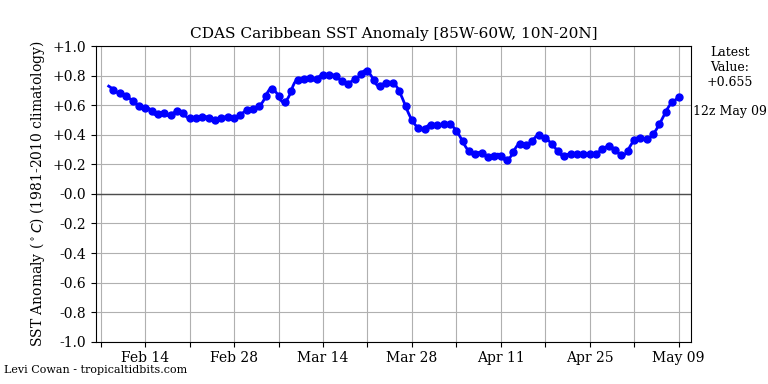
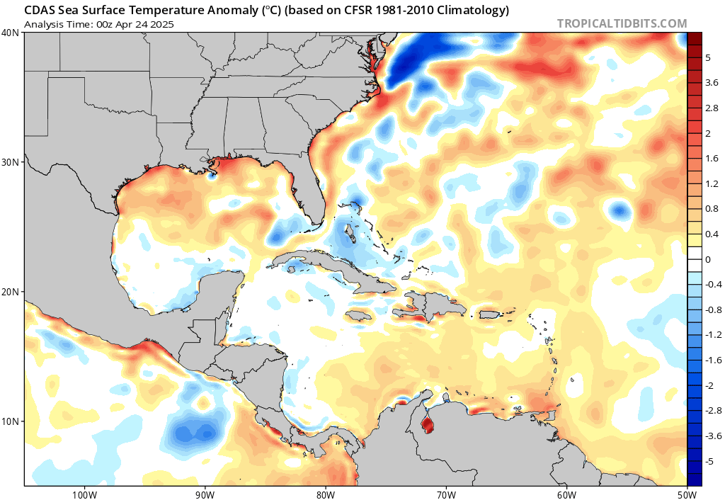
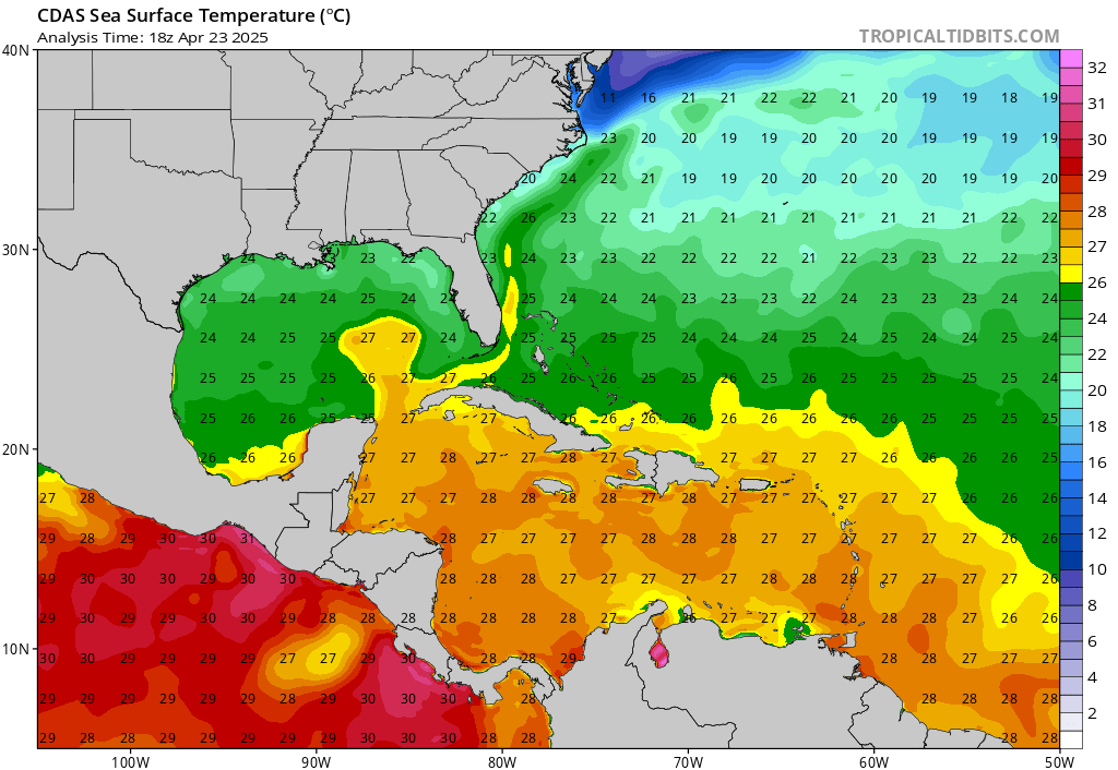
Saying that the Carribean is just "warm" is an understatement. It's running nearly a full degree C above average and has some of the highest SSTs and OHC in the world.
Image
Image
Image
1 likes   
Irene '11 Sandy '12 Hermine '16 5/15/2018 Derecho Fay '20 Isaias '20 Elsa '21 Henri '21 Ida '21

I am only a meteorology enthusiast who knows a decent amount about tropical cyclones. Look to the professional mets, the NHC, or your local weather office for the best information.


Return to “Talkin' Tropics”

Who is online

Users browsing this forum: Cpv17, NotSparta, Stratton23 and 30 guests