2020 Global Model Runs Discussion (Out thru day 16)

This is the general tropical discussion area. Anyone can take their shot at predicting a storms path.

Moderator: S2k Moderators

Forum rules

The posts in this forum are NOT official forecasts and should not be used as such. They are just the opinion of the poster and may or may not be backed by sound meteorological data. They are NOT endorsed by any professional institution or STORM2K. For official information, please refer to products from the National Hurricane Center and National Weather Service.

Help Support Storm2K
Message
Author
User avatar
robbielyn
Category 5
Category 5
Posts: 1298
Joined: Wed May 07, 2003 9:45 am
Location: brooksville, fl

Re: 2020 Global Model Runs Discussion (Out thru day 16)

#2821 Postby robbielyn » Sat Sep 26, 2020 7:38 pm

TheStormExpert wrote:Don’t count on a hurricane coming out of the Western Caribbean next week. May have to wait until later in the month we see something more significant.

https://twitter.com/derekortt/status/1309987091892367360

well then this will probably hit the peninsula. We always get the sheared slop
1 likes   
Robbielyn McCrary
I know just about enough to sound like I know what I'm talking about sometimes. But for your safety please follow the nhc for truly professional forecasting. :D

TheStormExpert

Re: 2020 Global Model Runs Discussion (Out thru day 16)

#2822 Postby TheStormExpert » Sat Sep 26, 2020 7:39 pm

:uarrow: Still not much in the way of intense members. Honestly I’m tired of this season and wouldn’t mind if we don’t see an October monster like most are expecting due to La Niña.
0 likes   

User avatar
SFLcane
S2K Supporter
S2K Supporter
Posts: 10163
Age: 47
Joined: Sat Jun 05, 2010 1:44 pm
Location: Lake Worth Florida

Re: 2020 Global Model Runs Discussion (Out thru day 16)

#2823 Postby SFLcane » Sat Sep 26, 2020 7:58 pm

2 likes   

User avatar
blp
Category 5
Category 5
Posts: 2840
Age: 46
Joined: Thu Sep 09, 2004 7:51 pm
Location: Miami, FL
Contact:

Re: 2020 Global Model Runs Discussion (Out thru day 16)

#2824 Postby blp » Sat Sep 26, 2020 8:16 pm

1 likes   
The following post is NOT an official forecast and should not be used as such. It is just the opinion of the poster and may or may not be backed by sound meteorological data. It is NOT endorsed by any professional institution including storm2k.org For Official Information please refer to the NHC and NWS products.

User avatar
cheezyWXguy
Category 5
Category 5
Posts: 6108
Joined: Mon Feb 13, 2006 12:29 am
Location: Dallas, TX

Re: 2020 Global Model Runs Discussion (Out thru day 16)

#2825 Postby cheezyWXguy » Sat Sep 26, 2020 8:36 pm


This is what concerns me about the cmc, and even the icon. Both have been more consistent run to run, and form it closer to the center of the anticyclone. It is worth noting that both have been better than the gfs and euro at predicting cyclogenesis this year
4 likes   

User avatar
Blown Away
S2K Supporter
S2K Supporter
Posts: 10147
Joined: Wed May 26, 2004 6:17 am

Re: 2020 Global Model Runs Discussion (Out thru day 16)

#2826 Postby Blown Away » Sat Sep 26, 2020 9:01 pm

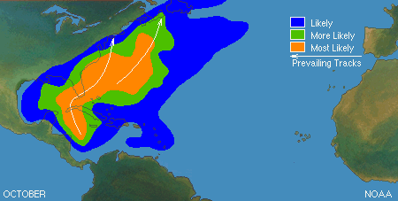
Most of the TC’s in October are pulled N from a trough sweeping down into the GOM/Caribbean. It’s hard to predict how a TC will react to the trough, especially 8+ days out, even 24 hours out there will be uncertainty how the trough/shear will effect a TC. Good example was Wilma.
2 likes   
Hurricane Eye Experience: David 79, Irene 99, Frances 04, Jeanne 04, Wilma 05... EYE COMING MY WAY IN 2024…
Hurricane Brush Experience: Andrew 92, Erin 95, Floyd 99, Matthew 16, Irma 17, Ian 22, Nicole 22…

User avatar
Spacecoast
Category 2
Category 2
Posts: 758
Joined: Thu Aug 31, 2017 2:03 pm

Re: 2020 Global Model Runs Discussion (Out thru day 16)

#2827 Postby Spacecoast » Sat Sep 26, 2020 9:22 pm

cheezyWXguy wrote:

This is what concerns me about the cmc, and even the icon. Both have been more consistent run to run, and form it closer to the center of the anticyclone. It is worth noting that both have been better than the gfs and euro at predicting cyclogenesis this year


Don't forget NAV...
Image


18z FSU has TC genesis probability:
0-48: 7% (12z NAV)
0-120: 23% (12z NAV)
0-168(below): 30% (12z NAV)
Image
1 likes   

User avatar
blp
Category 5
Category 5
Posts: 2840
Age: 46
Joined: Thu Sep 09, 2004 7:51 pm
Location: Miami, FL
Contact:

Re: 2020 Global Model Runs Discussion (Out thru day 16)

#2828 Postby blp » Sat Sep 26, 2020 9:27 pm

18z GFS Para still with the two systems.

Image
0 likes   
The following post is NOT an official forecast and should not be used as such. It is just the opinion of the poster and may or may not be backed by sound meteorological data. It is NOT endorsed by any professional institution including storm2k.org For Official Information please refer to the NHC and NWS products.

User avatar
StPeteMike
Category 2
Category 2
Posts: 631
Joined: Thu Jun 07, 2018 11:26 pm

Re: 2020 Global Model Runs Discussion (Out thru day 16)

#2829 Postby StPeteMike » Sat Sep 26, 2020 9:28 pm

The probability will certainly go up the next few days, up til Thursday. By then, we will certainly have 100% development within the next 48 hours.
0 likes   
The above post is not official and should not be used as such. It is the opinion of the poster and may or may not be backed by sound meteorological data. It is not endorsed by any professional institution or storm2k.org. For official information, please refer to the NHC and NWS products.

User avatar
cheezyWXguy
Category 5
Category 5
Posts: 6108
Joined: Mon Feb 13, 2006 12:29 am
Location: Dallas, TX

Re: 2020 Global Model Runs Discussion (Out thru day 16)

#2830 Postby cheezyWXguy » Sat Sep 26, 2020 9:30 pm

Blown Away wrote:Most of the TC’s in October are pulled N from a trough sweeping down into the GOM/Caribbean. It’s hard to predict how a TC will react to the trough, especially 8+ days out, even 24 hours out there will be uncertainty how the trough/shear will effect a TC. Good example was Wilma.

I still remember pretty vividly waking up that morning to Wilma. Went to bed the night before with a cat1, woke up and thought “ugh, wunderground is glitching out, I guess it didn’t strengthen and is stuck at 982mb”. Then I saw the satellite imagery...
8 likes   

User avatar
SFLcane
S2K Supporter
S2K Supporter
Posts: 10163
Age: 47
Joined: Sat Jun 05, 2010 1:44 pm
Location: Lake Worth Florida

Re: 2020 Global Model Runs Discussion (Out thru day 16)

#2831 Postby SFLcane » Sat Sep 26, 2020 9:34 pm

18z Para with Wilma 2.0

Image
4 likes   

SconnieCane
Category 4
Category 4
Posts: 998
Joined: Thu Aug 02, 2018 5:29 pm
Location: Madison, WI

Re: 2020 Global Model Runs Discussion (Out thru day 16)

#2832 Postby SconnieCane » Sat Sep 26, 2020 10:18 pm

Except without getting dramatically weakened over the Yucatan. :eek:
1 likes   

User avatar
toad strangler
S2K Supporter
S2K Supporter
Posts: 4543
Joined: Sun Jul 28, 2013 3:09 pm
Location: Earth
Contact:

Re: 2020 Global Model Runs Discussion (Out thru day 16)

#2833 Postby toad strangler » Sat Sep 26, 2020 10:27 pm

Temper the Wilma talk lol. She was an epic cyclone WELL before the NE turn over the Yucatán. The final product being a mature cyclone with an enlarged major hurricane eye that ravaged the FL peninsula without weakening in any significant way. Would be extremely unlikely to redux her...
6 likes   

User avatar
SFLcane
S2K Supporter
S2K Supporter
Posts: 10163
Age: 47
Joined: Sat Jun 05, 2010 1:44 pm
Location: Lake Worth Florida

Re: 2020 Global Model Runs Discussion (Out thru day 16)

#2834 Postby SFLcane » Sat Sep 26, 2020 10:36 pm

toad strangler wrote:Temper the Wilma talk lol. She was an epic cyclone WELL before the NE turn over the Yucatán. The final product being a mature cyclone with an enlarged major hurricane eye that ravaged the FL peninsula without weakening in any significant way. Would be extremely unlikely to redux her...


With that long wave pattern Track wise sure is possible. This run was 973mb at landfall near For Myers.
0 likes   

User avatar
cheezyWXguy
Category 5
Category 5
Posts: 6108
Joined: Mon Feb 13, 2006 12:29 am
Location: Dallas, TX

Re: 2020 Global Model Runs Discussion (Out thru day 16)

#2835 Postby cheezyWXguy » Sat Sep 26, 2020 10:40 pm

toad strangler wrote:Temper the Wilma talk lol. She was an epic cyclone WELL before the NE turn over the Yucatán. The final product being a mature cyclone with an enlarged major hurricane eye that ravaged the FL peninsula without weakening in any significant way. Would be extremely unlikely to redux her...

Why wouldn’t this talk be allowed? Aside from just general reminiscence, it’s a decent analog in track, pattern, and date. Despite the highest MPI and OHC values in the basin existing where this is projected to form, I haven’t seen a single post projecting that intensity, because no one has thought it reasonable to do so.
1 likes   

User avatar
Ubuntwo
Category 5
Category 5
Posts: 1406
Age: 31
Joined: Thu Oct 05, 2017 10:41 pm

Re: 2020 Global Model Runs Discussion (Out thru day 16)

#2836 Postby Ubuntwo » Sat Sep 26, 2020 11:01 pm

cheezyWXguy wrote:
toad strangler wrote:Temper the Wilma talk lol. She was an epic cyclone WELL before the NE turn over the Yucatán. The final product being a mature cyclone with an enlarged major hurricane eye that ravaged the FL peninsula without weakening in any significant way. Would be extremely unlikely to redux her...

Why wouldn’t this talk be allowed? Aside from just general reminiscence, it’s a decent analog in track, pattern, and date. Despite the highest MPI and OHC values in the basin existing where this is projected to form, I haven’t seen a single post projecting that intensity, because no one has thought it reasonable to do so.

Since it's such a common track/pattern this time of year anyways:
Image
There are dozens of suitable analogs, so it seems inappropriate to use the most extreme one?
3 likes   
Kendall -> SLO -> PBC

Memorable Storms: Katrina (for its Florida landfall...) Wilma Matthew Irma

User avatar
cheezyWXguy
Category 5
Category 5
Posts: 6108
Joined: Mon Feb 13, 2006 12:29 am
Location: Dallas, TX

Re: 2020 Global Model Runs Discussion (Out thru day 16)

#2837 Postby cheezyWXguy » Sat Sep 26, 2020 11:13 pm

Ubuntwo wrote:
cheezyWXguy wrote:
toad strangler wrote:Temper the Wilma talk lol. She was an epic cyclone WELL before the NE turn over the Yucatán. The final product being a mature cyclone with an enlarged major hurricane eye that ravaged the FL peninsula without weakening in any significant way. Would be extremely unlikely to redux her...

Why wouldn’t this talk be allowed? Aside from just general reminiscence, it’s a decent analog in track, pattern, and date. Despite the highest MPI and OHC values in the basin existing where this is projected to form, I haven’t seen a single post projecting that intensity, because no one has thought it reasonable to do so.

Since it's such a common track/pattern this time of year anyways:
https://www.nhc.noaa.gov/climo/images/october.gif
There are dozens of suitable analogs, so it seems inappropriate to use the most extreme one?

If I remember correctly it’s the most recent example as well. At least one of them. If it fits, it fits. Considering no one has made a comparison to intensity, what is inappropriate about this?
0 likes   

User avatar
toad strangler
S2K Supporter
S2K Supporter
Posts: 4543
Joined: Sun Jul 28, 2013 3:09 pm
Location: Earth
Contact:

Re: 2020 Global Model Runs Discussion (Out thru day 16)

#2838 Postby toad strangler » Sat Sep 26, 2020 11:16 pm

cheezyWXguy wrote:
Ubuntwo wrote:
cheezyWXguy wrote:Why wouldn’t this talk be allowed? Aside from just general reminiscence, it’s a decent analog in track, pattern, and date. Despite the highest MPI and OHC values in the basin existing where this is projected to form, I haven’t seen a single post projecting that intensity, because no one has thought it reasonable to do so.

Since it's such a common track/pattern this time of year anyways:
https://www.nhc.noaa.gov/climo/images/october.gif
There are dozens of suitable analogs, so it seems inappropriate to use the most extreme one?

If I remember correctly it’s the most recent example as well. At least one of them. If it fits, it fits. Considering no one has made a comparison to intensity, what is inappropriate about this?


I never said it wasn't allowed. YOU DID. It is my opinion that a Wilma type storm is a once in a lifetime IF THAT event. The track is climo backed for October for sure but NOT the strength. Good luck man ...
3 likes   

User avatar
Ubuntwo
Category 5
Category 5
Posts: 1406
Age: 31
Joined: Thu Oct 05, 2017 10:41 pm

Re: 2020 Global Model Runs Discussion (Out thru day 16)

#2839 Postby Ubuntwo » Sat Sep 26, 2020 11:17 pm

cheezyWXguy wrote:
Ubuntwo wrote:
cheezyWXguy wrote:Why wouldn’t this talk be allowed? Aside from just general reminiscence, it’s a decent analog in track, pattern, and date. Despite the highest MPI and OHC values in the basin existing where this is projected to form, I haven’t seen a single post projecting that intensity, because no one has thought it reasonable to do so.

Since it's such a common track/pattern this time of year anyways:
https://www.nhc.noaa.gov/climo/images/october.gif
There are dozens of suitable analogs, so it seems inappropriate to use the most extreme one?

If I remember correctly it’s the most recent example as well. At least one of them. If it fits, it fits. Considering no one has made a comparison to intensity, what is inappropriate about this?

If you're just going off track + time of year, Michael is quite close as well with several runs that far north. In terms of mode of genesis neither storm is an appropriate analog as this is wave-borne, not from a CAG.
3 likes   
Kendall -> SLO -> PBC

Memorable Storms: Katrina (for its Florida landfall...) Wilma Matthew Irma

User avatar
cheezyWXguy
Category 5
Category 5
Posts: 6108
Joined: Mon Feb 13, 2006 12:29 am
Location: Dallas, TX

Re: 2020 Global Model Runs Discussion (Out thru day 16)

#2840 Postby cheezyWXguy » Sat Sep 26, 2020 11:23 pm

Ubuntwo wrote:
cheezyWXguy wrote:
Ubuntwo wrote:Since it's such a common track/pattern this time of year anyways:
https://www.nhc.noaa.gov/climo/images/october.gif
There are dozens of suitable analogs, so it seems inappropriate to use the most extreme one?

If I remember correctly it’s the most recent example as well. At least one of them. If it fits, it fits. Considering no one has made a comparison to intensity, what is inappropriate about this?

If you're just going off track + time of year, Michael is quite close as well with several runs that far north. In terms of mode of genesis neither storm is an appropriate analog as this is wave-borne, not from a CAG.

This is the kind of discussion I was looking for. I didn’t realize Wilma was of purely CAG origin, I thought it was a complex wave interaction, but after looking it up, you are right. This is a valid reason to consider Wilma as an invalid analog.
2 likes   


Return to “Talkin' Tropics”

Who is online

Users browsing this forum: duilaslol, Google Adsense [Bot], Teban54 and 74 guests