https://twitter.com/thestevecop/status/1310266734423793665
2020 Global Model Runs Discussion (Out thru day 16)
Moderator: S2k Moderators
Forum rules

The posts in this forum are NOT official forecasts and should not be used as such. They are just the opinion of the poster and may or may not be backed by sound meteorological data. They are NOT endorsed by any professional institution or STORM2K. For official information, please refer to products from the National Hurricane Center and National Weather Service.
-
toad strangler

- S2K Supporter

- Posts: 4546
- Joined: Sun Jul 28, 2013 3:09 pm
- Location: Earth
- Contact:
Re: 2020 Global Model Runs Discussion (Out thru day 16)
psyclone wrote:GFS para is the new crazy Canadian (which now seems somewhat sane). This thread the past week certainly validates the prohibition against model storm threads. Time is ticking on cane season 2020 and i'm starting to feel good although i've been known to jump the gun...
Dude there are still 4 days left in September. Come back one MONTH from now with this. You aren't jumping the gun, you are jumping the Grand Canyon.
Last edited by toad strangler on Sun Sep 27, 2020 12:47 pm, edited 1 time in total.
8 likes
My Weather Station
https://www.wunderground.com/dashboard/pws/KFLPORTS603
https://www.wunderground.com/dashboard/pws/KFLPORTS603
Re: 2020 Global Model Runs Discussion (Out thru day 16)
As the GEFS (posted by Gatorcane) shows we could easily have something form and totally miss the US to the south and east (like a Michelle 2001 set up).
1 likes

Re: 2020 Global Model Runs Discussion (Out thru day 16)
I know this was probably discussed already. So the GFS-P operational run is still the new model and they left the old GFS operational run in place? I know they replaced the GEFS with the GEFS-P but not sure what happened in the ops run. Sorry I am confused. Thank you in advance.
0 likes
The following post is NOT an official forecast and should not be used as such. It is just the opinion of the poster and may or may not be backed by sound meteorological data. It is NOT endorsed by any professional institution including storm2k.org For Official Information please refer to the NHC and NWS products.
-
Shell Mound
- Category 5

- Posts: 2432
- Age: 33
- Joined: Thu Sep 07, 2017 3:39 pm
- Location: St. Petersburg, FL → Scandinavia
Re: 2020 Global Model Runs Discussion (Out thru day 16)
psyclone wrote:As the GEFS (posted by Gatorcane) shows we could easily have something form and totally miss the US to the south and east (like a Michelle 2001 set up).
Going by climatology, I’m willing to conclude that if a strong system were to form, it would most likely traverse Cuba and miss Florida to its east. A stronger system would be more likely to deviate eastward as it feels the influence of a potent mid-level trough. Of all the major hurricanes that a) formed in the W Caribbean in October and b) struck peninsular Florida, only one—King ‘50 (115 knots / 955 mb)—struck the state as a Category-4+ hurricane. All the others were mid-range Cat-3 hurricanes (≤105 knots) or weaker at landfall. I’m excluding Michael because a) it struck the Panhandle and b) was exceptional. Of course, at this stage I’m still rather bearish on the prospects of a potent system, so I’ll need to see another few days’ trends before “pulling the trigger,” so to speak. At this stage I think something will most likely develop during the first week of October, but is probably destined to only reach TS or low-end hurricane status at best. I think Florida is likely to be spared of Cat-4+ hits for the rest of the year, but Cuba and the Bahamas are certainly vulnerable.
1 likes
CVW / MiamiensisWx / Shell Mound
The posts in this forum are NOT official forecasts and should not be used as such. They are just the opinion of the poster and may or may not be backed by sound meteorological data. They are NOT endorsed by any professional institution or STORM2K. For official information, please refer to products from the NHC and NWS.
-
toad strangler
- S2K Supporter
- Posts: 4546
- Joined: Sun Jul 28, 2013 3:09 pm
- Location: Earth
- Contact:
Re: 2020 Global Model Runs Discussion (Out thru day 16)
Shell Mound wrote:psyclone wrote:As the GEFS (posted by Gatorcane) shows we could easily have something form and totally miss the US to the south and east (like a Michelle 2001 set up).
Going by climatology, I’m willing to conclude that if a strong system were to form, it would most likely traverse Cuba and miss Florida to its east. A stronger system would be more likely to deviate eastward as it feels the influence of a potent mid-level trough. Of all the major hurricanes that a) formed in the W Caribbean in October and b) struck peninsular Florida, only one—King ‘50 (115 knots / 955 mb)—struck the state as a Category-4+ hurricane. All the others were mid-range Cat-3 hurricanes (≤105 knots) or weaker at landfall. I’m excluding Michael because a) it struck the Panhandle and b) was exceptional. Of course, at this stage I’m still rather bearish on the prospects of a potent system, so I’ll need to see another few days’ trends before “pulling the trigger,” so to speak. At this stage I think something will most likely develop during the first week of October, but is probably destined to only reach TS or low-end hurricane status at best. I think Florida is likely to be spared of Cat-4+ hits for the rest of the year, but Cuba and the Bahamas are certainly vulnerable.
You are beating this to death. Every page you are saying the same thing. It's like advertisement pop ups lol. Who is even insinuating that a strong storm is on the horizon? I don't see any chatter like that. Just basic model run chatter.
0 likes
My Weather Station
https://www.wunderground.com/dashboard/pws/KFLPORTS603
https://www.wunderground.com/dashboard/pws/KFLPORTS603
-
CyclonicFury

- Category 5
- Posts: 2033
- Age: 27
- Joined: Sun Jul 02, 2017 12:32 pm
- Location: NC
- Contact:
Re: 2020 Global Model Runs Discussion (Out thru day 16)
Shell Mound wrote:psyclone wrote:As the GEFS (posted by Gatorcane) shows we could easily have something form and totally miss the US to the south and east (like a Michelle 2001 set up).
Going by climatology, I’m willing to conclude that if a strong system were to form, it would most likely traverse Cuba and miss Florida to its east. A stronger system would be more likely to deviate eastward as it feels the influence of a potent mid-level trough. Of all the major hurricanes that a) formed in the W Caribbean in October and b) struck peninsular Florida, only one—King ‘50 (115 knots / 955 mb)—struck the state as a Category-4+ hurricane. All the others were mid-range Cat-3 hurricanes (≤105 knots) or weaker at landfall. I’m excluding Michael because a) it struck the Panhandle and b) was exceptional. Of course, at this stage I’m still rather bearish on the prospects of a potent system, so I’ll need to see another few days’ trends before “pulling the trigger,” so to speak. At this stage I think something will most likely develop during the first week of October, but is probably destined to only reach TS or low-end hurricane status at best. I think Florida is likely to be spared of Cat-4+ hits for the rest of the year, but Cuba and the Bahamas are certainly vulnerable.
Why are you always so confident Florida will be spared?
2 likes
NCSU B.S. in Meteorology Class of 2021. Tropical weather blogger at http://www.cyclonicfury.com. My forecasts and thoughts are NOT official, for official forecasts please consult the National Hurricane Center.
-
DestinHurricane

- Category 4

- Posts: 935
- Joined: Tue May 01, 2018 8:05 am
- Location: New York, NY
Re: 2020 Global Model Runs Discussion (Out thru day 16)
Shell Mound wrote:psyclone wrote:As the GEFS (posted by Gatorcane) shows we could easily have something form and totally miss the US to the south and east (like a Michelle 2001 set up).
Going by climatology, I’m willing to conclude that if a strong system were to form, it would most likely traverse Cuba and miss Florida to its east. A stronger system would be more likely to deviate eastward as it feels the influence of a potent mid-level trough. Of all the major hurricanes that a) formed in the W Caribbean in October and b) struck peninsular Florida, only one—King ‘50 (115 knots / 955 mb)—struck the state as a Category-4+ hurricane. All the others were mid-range Cat-3 hurricanes (≤105 knots) or weaker at landfall. I’m excluding Michael because a) it struck the Panhandle and b) was exceptional. Of course, at this stage I’m still rather bearish on the prospects of a potent system, so I’ll need to see another few days’ trends before “pulling the trigger,” so to speak. At this stage I think something will most likely develop during the first week of October, but is probably destined to only reach TS or low-end hurricane status at best. I think Florida is likely to be spared of Cat-4+ hits for the rest of the year, but Cuba and the Bahamas are certainly vulnerable.
Not only are you beating this to death, it isn't even correct. Climatology favors a SW FL hit for a hurricane in Western Caribbean this time of year. It certainly could miss FL to the east, that's just not what is favored by climo. West of FL peninsula to panhandle also is a possibility.
Last edited by DestinHurricane on Sun Sep 27, 2020 1:35 pm, edited 2 times in total.
2 likes
Michael 2018

Re: 2020 Global Model Runs Discussion (Out thru day 16)
Cape Verde season is over in October so I was expecting some home brew activity in the gulf, all the models see is a Caribbean system?
0 likes
-
Spacecoast

- Category 2

- Posts: 773
- Joined: Thu Aug 31, 2017 2:03 pm
Re: 2020 Global Model Runs Discussion (Out thru day 16)
blp wrote:I know this was probably discussed already. So the GFS-P operational run is still the new model and they left the old GFS operational run in place? I know they replaced the GEFS with the GEFS-P but not sure what happened in the ops run. Sorry I am confused. Thank you in advance.
GFS-P operational model is GFS ver16
'old' GFS operational is GFS ver15
Differences in performance between the two operational (ver15 vs ver16) canbe found here:
https://www.emc.ncep.noaa.gov/users/meg/gfsv16/pptx/MEG_9-17-20_GFSv16_SOO_Team_Evaluation.pdf
GEFS is now ver12, and fully revamped ,formally known as GEFS-P
4 likes
-
Spacecoast
- Category 2
- Posts: 773
- Joined: Thu Aug 31, 2017 2:03 pm
Re: 2020 Global Model Runs Discussion (Out thru day 16)
Spacecoast wrote:blp wrote:I know this was probably discussed already. So the GFS-P operational run is still the new model and they left the old GFS operational run in place? I know they replaced the GEFS with the GEFS-P but not sure what happened in the ops run. Sorry I am confused. Thank you in advance.
GFS-P operational model is GFS ver16
'old' GFS operational is GFS ver15
Differences in performance between the two operational (ver15 vs ver16) canbe found here:
https://www.emc.ncep.noaa.gov/users/meg/gfsv16/pptx/MEG_9-17-20_GFSv16_SOO_Team_Evaluation.pdf
GEFS is now ver12, and fully revamped ,formally known as GEFS-P
Key messages from slides:


5 likes
-
MarioProtVI
- Category 5
- Posts: 1034
- Age: 24
- Joined: Sun Sep 29, 2019 7:33 pm
- Location: New Jersey
Re: 2020 Global Model Runs Discussion (Out thru day 16)
Shell Mound wrote:MarioProtVI wrote:Shell Mound wrote:There’s been a wall of shear over the western Caribbean since at least 2011. Why should it let up just now? Furthermore, shear thus far has been consistently higher than in a typical Niña year, hence lower-than-expected ACE to date. At this point I think the western Caribbean will continue to be a “dead zone” as far as major hurricanes are concerned, owing to the influence of Niño-like TUTT and STJ activity. As someone previously mentioned, another Michael in the Gulf of Mexico would be exceptional.
We still have the entire month of October to get through, and also the models are probably not taking the La Niña into effect (particularly the GFS it seems). Don’t give up at all yet because 2020 is known for surprises, and the Western Caribbean has shown it is favourable this year more then other years with Marco and Nana (the former being a strong tropical storm before exiting and the latter becoming a brief C1).
Well, so far 2020 has not behaved like a “typical” Niña year, given that ACE has been much lower than it should have been relative to NS. That’s certainly surprising, but it doesn’t garner the attention it merits, perhaps because people are more interested in bullish vs. bearish records, understandably so. Additionally, besides the GFS-P, most of the EPS members show broad, elongated MSLP fields, and only a handful show even a marginal hurricane, indicating that the EPS also shows strong westerly shear over the Gulf of Mexico, Yucatán Channel, and extreme northwestern Caribbean Sea. There hasn’t been a MH in the (north-)western Caribbean since Rina ‘11. As for Nana, it was questionably a hurricane at best. Currently models show Niño-like STJ activity near western Cuba as the potential system consolidates, so anything that forms would be highly sheared and weak at best, probably no more than a high-end TS or very marginal Cat-1, with strongest winds occurring spottily in squalls displaced well to the east of the centre.
The same things were said for Barry last year and it remained a C1. Plus, the NHC can have data access to things we cant access to prove an intensity estimate, so they must have something else that supported a hurricane that we can’t find. IMO, the hurricane force winds occurred in a very tiny spot that not even the town exposed to the RMW experienced.
0 likes
Re: 2020 Global Model Runs Discussion (Out thru day 16)
Spacecoast wrote:Spacecoast wrote:blp wrote:I know this was probably discussed already. So the GFS-P operational run is still the new model and they left the old GFS operational run in place? I know they replaced the GEFS with the GEFS-P but not sure what happened in the ops run. Sorry I am confused. Thank you in advance.
GFS-P operational model is GFS ver16
'old' GFS operational is GFS ver15
Differences in performance between the two operational (ver15 vs ver16) canbe found here:
https://www.emc.ncep.noaa.gov/users/meg/gfsv16/pptx/MEG_9-17-20_GFSv16_SOO_Team_Evaluation.pdf
GEFS is now ver12, and fully revamped ,formally known as GEFS-P
Key messages from slides:
https://i.ibb.co/h8g9RZY/v16aa.jpg
https://i.ibb.co/MnMR6Qg/v16a.jpg
https://i.ibb.co/6D9DFVZ/v16.jpg
So, there it is. The para-GFS has missed fewer geneses but has also had more fake storms vs the operational GFS. Also, the average intensity on the para-GFS has been higher than the operational and closer to reality on average. In summary, the para-GFS has been more TC friendly so to speak. But sometimes too friendly. The para is closer to the CMC and ICON than the operational GFS is but I'd bet better than those two. But the operational GFS has had a hard time with missing geneses at times. My advice is to just be wary with all models/take them with a grain lol.
3 likes
Personal Forecast Disclaimer:
The posts in this forum are NOT official forecasts and should not be used as such. They are just the opinion of the poster and may or may not be backed by sound meteorological data. They are NOT endorsed by any professional institution or storm2k.org. For official information, please refer to the NHC and NWS products.
The posts in this forum are NOT official forecasts and should not be used as such. They are just the opinion of the poster and may or may not be backed by sound meteorological data. They are NOT endorsed by any professional institution or storm2k.org. For official information, please refer to the NHC and NWS products.
-
gatorcane

- S2K Supporter
- Posts: 23708
- Age: 48
- Joined: Sun Mar 13, 2005 3:54 pm
- Location: Boca Raton, FL
Re: 2020 Global Model Runs Discussion (Out thru day 16)
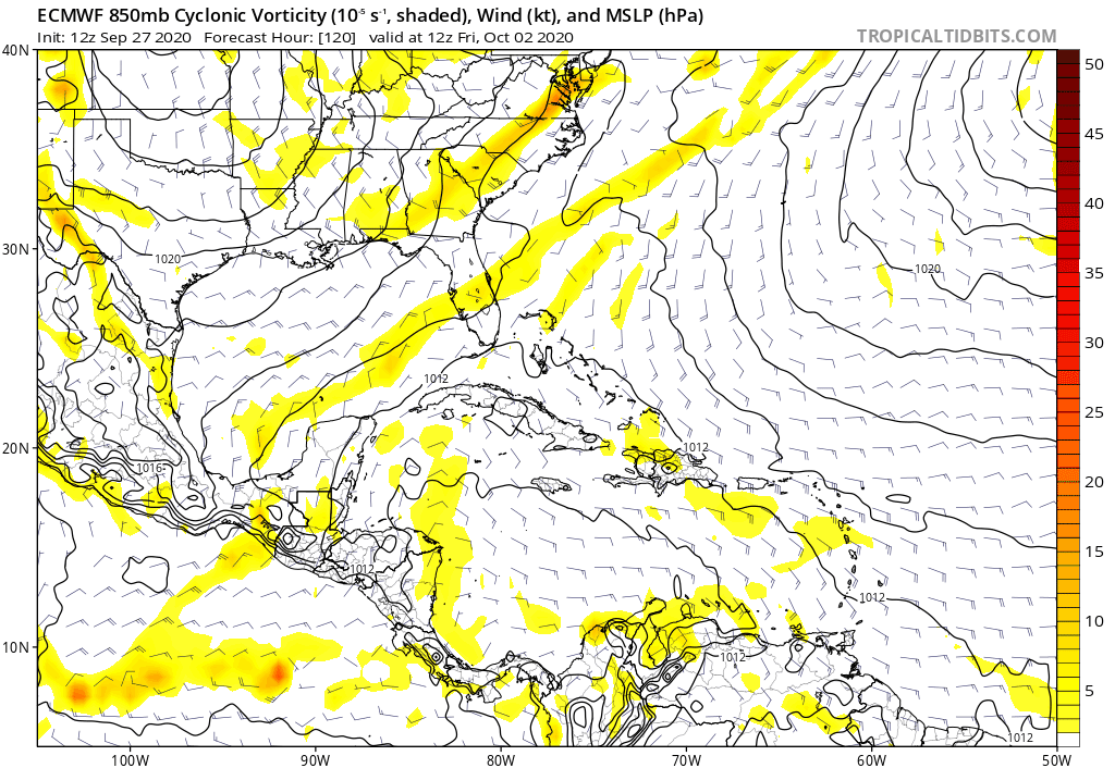
The Euro continues to not be impressed but we do note it shows a more “trackable” area of vorticity that moves across the Central and Western Caribbean. 120 to 240 hour animation below:
3 likes
Re: 2020 Global Model Runs Discussion (Out thru day 16)
Is that a potential TC genesis in the W Caribbean on the 240 of the 12Z Euro?

Edit: It isn't far from a big 200 mb high:

Edit: It isn't far from a big 200 mb high:
2 likes
Personal Forecast Disclaimer:
The posts in this forum are NOT official forecasts and should not be used as such. They are just the opinion of the poster and may or may not be backed by sound meteorological data. They are NOT endorsed by any professional institution or storm2k.org. For official information, please refer to the NHC and NWS products.
The posts in this forum are NOT official forecasts and should not be used as such. They are just the opinion of the poster and may or may not be backed by sound meteorological data. They are NOT endorsed by any professional institution or storm2k.org. For official information, please refer to the NHC and NWS products.
Re: 2020 Global Model Runs Discussion (Out thru day 16)
Spacecoast wrote:Spacecoast wrote:blp wrote:I know this was probably discussed already. So the GFS-P operational run is still the new model and they left the old GFS operational run in place? I know they replaced the GEFS with the GEFS-P but not sure what happened in the ops run. Sorry I am confused. Thank you in advance.
GFS-P operational model is GFS ver16
'old' GFS operational is GFS ver15
Differences in performance between the two operational (ver15 vs ver16) canbe found here:
https://www.emc.ncep.noaa.gov/users/meg/gfsv16/pptx/MEG_9-17-20_GFSv16_SOO_Team_Evaluation.pdf
GEFS is now ver12, and fully revamped ,formally known as GEFS-P
Key messages from slides:
https://i.ibb.co/h8g9RZY/v16aa.jpg
https://i.ibb.co/MnMR6Qg/v16a.jpg
https://i.ibb.co/6D9DFVZ/v16.jpg
Thank you for posting this.
Key takeaways for me are:
For Track:
GFSv16 had slightly improved track forecasts for days 3-6 but a stronger right of track bias at
all forecast times compared to GFSv15.
For Intensity:
GFSv16 reduced a negative intensity bias and a negative bias in the radii of 34-kt winds
beyond day 2. GFSv16 creates more intense and larger hurricanes compared to GFSv15.
Overall:
GFSv16 creates more tropical cyclones overall leading to more hits but also more false
alarms compared to v15.
So using this guidance I think a middle of the road approach is most warranted. Looks like the Euro is going to have to settle these disagreements. Based on the 12z run I expect the Euro to get stronger on the next run but no go overboard. Looks most plausible.
1 likes
The following post is NOT an official forecast and should not be used as such. It is just the opinion of the poster and may or may not be backed by sound meteorological data. It is NOT endorsed by any professional institution including storm2k.org For Official Information please refer to the NHC and NWS products.
-
SFLcane

- S2K Supporter
- Posts: 10281
- Age: 48
- Joined: Sat Jun 05, 2010 1:44 pm
- Location: Lake Worth Florida
Re: 2020 Global Model Runs Discussion (Out thru day 16)
LarryWx wrote:Is that a potential TC genesis in the W Caribbean on the 240 of the 12Z Euro?
https://i.imgur.com/XKSwTPq.png
Edit: It isn't far from a big 200 mb high:
https://i.imgur.com/sDrZElj.png
Yep! Perhaps coming around.
0 likes
-
otowntiger
- Category 5
- Posts: 1932
- Joined: Tue Aug 31, 2004 7:06 pm
Re: 2020 Global Model Runs Discussion (Out thru day 16)
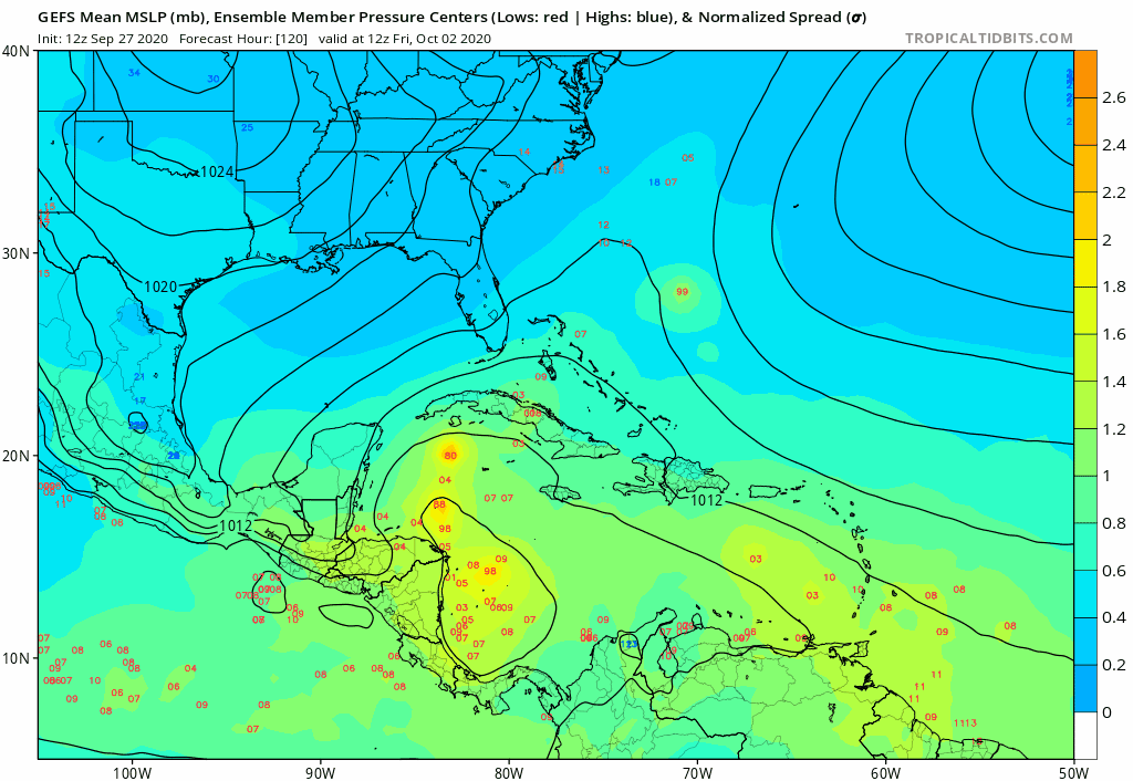
. Most of those seem well positioned to miss the CONUS to the East.gatorcane wrote:MUCH stronger signal from the GEFS
Also seems to be leaning more toward the eastern area for development.
120 to 240 hour animation below
https://i.postimg.cc/xdGY97t5/gfs-ememb-lowlocs-watl-fh120-240.gif
2 likes
-
Deshaunrob17
- Tropical Storm

- Posts: 211
- Joined: Tue Aug 18, 2020 7:49 am
Re: 2020 Global Model Runs Discussion (Out thru day 16)
MarioProtVI wrote:Shell Mound wrote:MarioProtVI wrote:We still have the entire month of October to get through, and also the models are probably not taking the La Niña into effect (particularly the GFS it seems). Don’t give up at all yet because 2020 is known for surprises, and the Western Caribbean has shown it is favourable this year more then other years with Marco and Nana (the former being a strong tropical storm before exiting and the latter becoming a brief C1).
Well, so far 2020 has not behaved like a “typical” Niña year, given that ACE has been much lower than it should have been relative to NS. That’s certainly surprising, but it doesn’t garner the attention it merits, perhaps because people are more interested in bullish vs. bearish records, understandably so. Additionally, besides the GFS-P, most of the EPS members show broad, elongated MSLP fields, and only a handful show even a marginal hurricane, indicating that the EPS also shows strong westerly shear over the Gulf of Mexico, Yucatán Channel, and extreme northwestern Caribbean Sea. There hasn’t been a MH in the (north-)western Caribbean since Rina ‘11. As for Nana, it was questionably a hurricane at best. Currently models show Niño-like STJ activity near western Cuba as the potential system consolidates, so anything that forms would be highly sheared and weak at best, probably no more than a high-end TS or very marginal Cat-1, with strongest winds occurring spottily in squalls displaced well to the east of the centre.
The same things were said for Barry last year and it remained a C1. Plus, the NHC can have data access to things we cant access to prove an intensity estimate, so they must have something else that supported a hurricane that we can’t find. IMO, the hurricane force winds occurred in a very tiny spot that not even the town exposed to the RMW experienced.
The only thing I'll.say is part of the reason the ACE is not as impressive as the number of storms is that we had 8 storms forming before August. Most systems that form before August are usually weak and short lived and to have 8 forming before August will cause the Ace to be low relative to the number of storms.
The next thing I'll say is if some the storms that formed in the MDR had taken a more southern track, they would have added more ACE.. Example, Paulette could have added more ACE if she move more south..
0 likes

Re: 2020 Global Model Runs Discussion (Out thru day 16)
SFLcane wrote:LarryWx wrote:Is that a potential TC genesis in the W Caribbean on the 240 of the 12Z Euro?
https://i.imgur.com/XKSwTPq.png
Edit: It isn't far from a big 200 mb high:
https://i.imgur.com/sDrZElj.png
Yep! Perhaps coming around.
12z EPS significantly more active than 00z or 12z yesterday. I'm not sure but it looks to me to be the most active ECMWF ensemble run yet on these potential system(s).
2 likes
The posts in this forum are NOT official forecast and should not be used as such. They are just the opinion of the poster and may or may not be backed by sound meteorological data. They are NOT endorsed by any professional institution or STORM2K. For official information, refer to products from the National Hurricane Center and National Weather Service.
Who is online
Users browsing this forum: Yellow Evan and 128 guests