Up to 30% in 5 days.
788
ABNT20 KNHC 281138
TWOAT
Tropical Weather Outlook
NWS National Hurricane Center Miami FL
800 AM EDT Mon Sep 28 2020
For the North Atlantic...Caribbean Sea and the Gulf of Mexico:
A broad area of low pressure is expected to form over the western
Caribbean Sea in a few days. Some gradual development of the
disturbance will be possible thereafter while the system moves
slowly west-northwestward over the northwestern Caribbean Sea.
* Formation chance through 48 hours...low...near 0 percent.
* Formation chance through 5 days...low...30 percent.
$$
Forecaster Zelinsky
Tropical Wave in the West-Central Caribbean (Is Invest 91L)
Moderator: S2k Moderators
Forum rules

The posts in this forum are NOT official forecasts and should not be used as such. They are just the opinion of the poster and may or may not be backed by sound meteorological data. They are NOT endorsed by any professional institution or STORM2K. For official information, please refer to products from the National Hurricane Center and National Weather Service.


Re: Possible development in Western Caribbean
Why is the GFS and GFS Para so far off in their solutions?
0 likes
-
SFLcane

- S2K Supporter

- Posts: 10281
- Age: 48
- Joined: Sat Jun 05, 2010 1:44 pm
- Location: Lake Worth Florida
Re: Possible development in Western Caribbean
boca wrote:Why is the GFS and GFS Para so far off in their solutions?
What’s off?
They both show an intensifying cyclone in the NW Caribbean Sea. Track and intensity obviously sketchy this far out.
0 likes
Re: Possible development in Western Caribbean
I was taking about the track,GFS off of Texas and Para off west of Tampa.
0 likes
-
AutoPenalti
- Category 5

- Posts: 4091
- Age: 29
- Joined: Mon Aug 17, 2015 4:16 pm
- Location: Ft. Lauderdale, Florida
Re: Possible development in Western Caribbean
Very sheared, much like a June system.
1 likes
The posts in this forum are NOT official forecasts and should not be used as such. They are just the opinion of the poster and may or may not be backed by sound meteorological data. They are NOT endorsed by any professional institution or STORM2K. For official information, please refer to products from the NHC and NWS.
Model Runs Cheat Sheet:
GFS (5:30 AM/PM, 11:30 AM/PM)
HWRF, GFDL, UKMET, NAVGEM (6:30-8:00 AM/PM, 12:30-2:00 AM/PM)
ECMWF (1:45 AM/PM)
TCVN is a weighted averaged
-
SFLcane
- S2K Supporter
- Posts: 10281
- Age: 48
- Joined: Sat Jun 05, 2010 1:44 pm
- Location: Lake Worth Florida
Re: Possible development in Western Caribbean
AutoPenalti wrote:
Very sheared, much like a June system.
https://twitter.com/thestevecop/status/1310266734423793665
0 likes
-
TheStormExpert
Re: Possible development in Western Caribbean
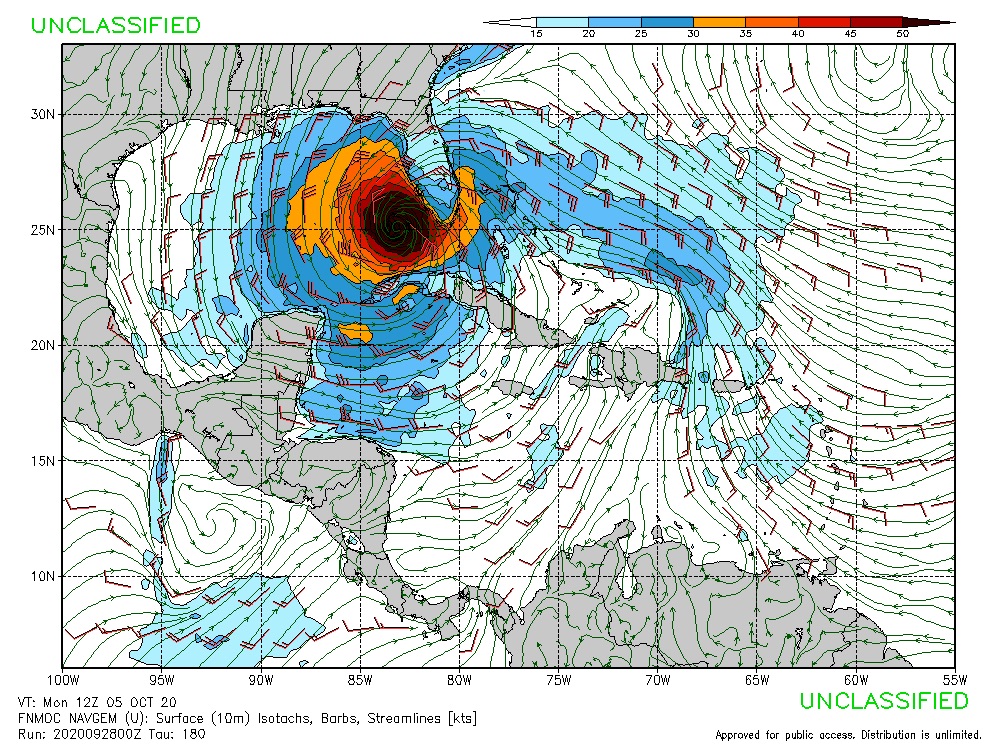
SFLcane wrote:Can I post the Nogaps? It sure is bullish
https://i.postimg.cc/zv18Y8n6/2-DEA3951-E9-F9-444-A-A781-E1-B59890-AA33.jpg
When isn’t it bullish!?
Then again the NOGAPS and the GFS-Para are the only ones bullish.
1 likes
-
TheStormExpert
Re: Possible development in Western Caribbean
SFLcane wrote:boca wrote:Why is the GFS and GFS Para so far off in their solutions?
What’s off?
They both show an intensifying cyclone in the NW Caribbean Sea. Track and intensity obviously sketchy this far out.
The GFS-Para shows a much stronger storm then the GFS.
0 likes
-
SFLcane
- S2K Supporter
- Posts: 10281
- Age: 48
- Joined: Sat Jun 05, 2010 1:44 pm
- Location: Lake Worth Florida
Re: Possible development in Western Caribbean
06z para with development starting as early as late this week.

0 likes

Re: Possible development in Western Caribbean
SFLcane wrote:06z para with development starting as early as late this week.
https://i.imgur.com/NZeISOd.gif
That has genesis much further north and east. Different mechanism than the tropical wave?
0 likes
-
otowntiger
- Category 5
- Posts: 1932
- Joined: Tue Aug 31, 2004 7:06 pm
Re: Possible development in Western Caribbean
AutoPenalti wrote:
Very sheared, much like a June system.
Or like an October system. Sheared systems in October are more common, I believe, than major storms.
2 likes
-
AutoPenalti
- Category 5
- Posts: 4091
- Age: 29
- Joined: Mon Aug 17, 2015 4:16 pm
- Location: Ft. Lauderdale, Florida
Re: Possible development in Western Caribbean
SFLcane wrote:06z para with development starting as early as late this week.
https://i.imgur.com/NZeISOd.gif
That's pretty much within the 5 day window...
0 likes
The posts in this forum are NOT official forecasts and should not be used as such. They are just the opinion of the poster and may or may not be backed by sound meteorological data. They are NOT endorsed by any professional institution or STORM2K. For official information, please refer to products from the NHC and NWS.
Model Runs Cheat Sheet:
GFS (5:30 AM/PM, 11:30 AM/PM)
HWRF, GFDL, UKMET, NAVGEM (6:30-8:00 AM/PM, 12:30-2:00 AM/PM)
ECMWF (1:45 AM/PM)
TCVN is a weighted averaged
-
Shell Mound
- Category 5
- Posts: 2432
- Age: 33
- Joined: Thu Sep 07, 2017 3:39 pm
- Location: St. Petersburg, FL → Scandinavia
Re: Possible development in Western Caribbean
otowntiger wrote:AutoPenalti wrote:
Very sheared, much like a June system.
Or like an October system. Sheared systems in October are more common, I believe, than major storms.
Yes, but one would expect more favourable conditions during La Niña. Yet most ensemble members still show a fairly weak, tilted system.
0 likes
CVW / MiamiensisWx / Shell Mound
The posts in this forum are NOT official forecasts and should not be used as such. They are just the opinion of the poster and may or may not be backed by sound meteorological data. They are NOT endorsed by any professional institution or STORM2K. For official information, please refer to products from the NHC and NWS.
-
SFLcane
- S2K Supporter
- Posts: 10281
- Age: 48
- Joined: Sat Jun 05, 2010 1:44 pm
- Location: Lake Worth Florida
Re: Possible development in Western Caribbean
For Florida This is why we watch the Caribbean in October.

2 likes
-
wxman57

- Moderator-Pro Met

- Posts: 23174
- Age: 68
- Joined: Sat Jun 21, 2003 8:06 pm
- Location: Houston, TX (southwest)
Re: Possible development in Western Caribbean
I see lots and lots of strong westerly wind shear across the central and northern Gulf over the coming week. That would indicate anything moving into the southern Gulf would experience the shear and would likely track NE, either toward Florida or across Cuba toward the Bahamas. Typical track this time of year. That's a fairly strong cold front moving out across the Gulf today. I don't see this being a threat to TX or LA, and likely MS or AL Note that I do have vacation days scheduled this week. The tropics have been informed.
7 likes
-
SFLcane
- S2K Supporter
- Posts: 10281
- Age: 48
- Joined: Sat Jun 05, 2010 1:44 pm
- Location: Lake Worth Florida
Re: Possible development in Western Caribbean
wxman57 wrote:I see lots and lots of strong westerly wind shear across the central and northern Gulf over the coming week. That would indicate anything moving into the southern Gulf would experience the shear and would likely track NE, either toward Florida or across Cuba toward the Bahamas. Typical track this time of year. That's a fairly strong cold front moving out across the Gulf today. I don't see this being a threat to TX or LA, and likely MS or AL Note that I do have vacation days scheduled this week. The tropics have been informed.
So we watch in Florida.
0 likes
-
Shell Mound
- Category 5
- Posts: 2432
- Age: 33
- Joined: Thu Sep 07, 2017 3:39 pm
- Location: St. Petersburg, FL → Scandinavia
Re: Possible development in Western Caribbean
SFLcane wrote:For Florida This is why we watch the Caribbean in October.
https://i.imgur.com/acW29OP.gif
I still see too much shear for this to be much of a concern. I expect development and am not precluding a threat to peninsular Florida, but the setup indicates very strong shear in place, as the precipitation field illustrates. There is no southern quadrant to speak of: all the convection is displaced to the eastern side of the centre. Anything that forms would likely attain minimal hurricane status at most, given that the vectors are perpendicular rather than parallel to the path of the system. A sloppy Cat-1 or even a low-end Cat-2 heading into the Everglades National Park is nothing to “write home about,” especially given all the hype about how 2020 was going to bring Cat-5s into Houston and/or Miami. I am in total agreement with wxman57 on this system. A “threat” to Florida it will be, certainly, if you stretch the definition of a “threat,” given that any potential system will be disorganised and moving quickly, reducing the potential for heavy rainfall.
1 likes
CVW / MiamiensisWx / Shell Mound
The posts in this forum are NOT official forecasts and should not be used as such. They are just the opinion of the poster and may or may not be backed by sound meteorological data. They are NOT endorsed by any professional institution or STORM2K. For official information, please refer to products from the NHC and NWS.
Who is online
Users browsing this forum: Google [Bot], tolakram and 182 guests