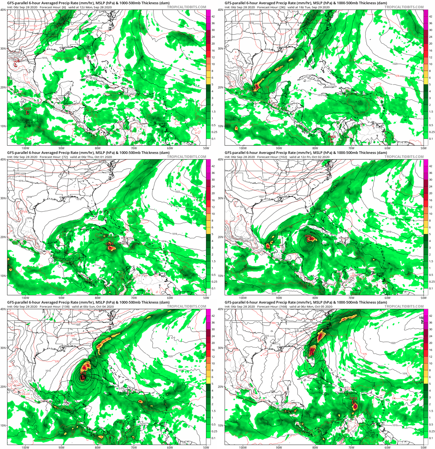
Tropical Wave in the West-Central Caribbean (Is Invest 91L)

This is the general tropical discussion area. Anyone can take their shot at predicting a storms path.

Moderator: S2k Moderators

Forum rules

The posts in this forum are NOT official forecasts and should not be used as such. They are just the opinion of the poster and may or may not be backed by sound meteorological data. They are NOT endorsed by any professional institution or STORM2K. For official information, please refer to products from the National Hurricane Center and National Weather Service.

Help Support Storm2K
Message
Author
TheStormExpert

Re: Possible development in Western Caribbean

#81 Postby TheStormExpert » Mon Sep 28, 2020 8:13 am

wxman57 wrote:I see lots and lots of strong westerly wind shear across the central and northern Gulf over the coming week. That would indicate anything moving into the southern Gulf would experience the shear and would likely track NE, either toward Florida or across Cuba toward the Bahamas. Typical track this time of year. That's a fairly strong cold front moving out across the Gulf today. I don't see this being a threat to TX or LA, and likely MS or AL Note that I do have vacation days scheduled this week. The tropics have been informed.

So it sounds to me that you’re not too bullish on anything significant since there will be shear if and when this enters the Gulf?
1 likes   

TheStormExpert

Re: Possible development in Western Caribbean

#82 Postby TheStormExpert » Mon Sep 28, 2020 8:16 am

Shell Mound wrote:
SFLcane wrote:For Florida This is why we watch the Caribbean in October.

https://i.imgur.com/acW29OP.gif

I still see too much shear for this to be much of a concern. I expect development and am not precluding a threat to peninsular Florida, but the setup indicates very strong shear in place, as the precipitation field illustrates. There is no southern quadrant to speak of: all the convection is displaced to the eastern side of the centre. Anything that forms would likely attain minimal hurricane status at most, given that the vectors are perpendicular rather than parallel to the path of the system. A sloppy Cat-1 or even a low-end Cat-2 heading into the Everglades National Park is nothing to “write home about,” especially given all the hype about how 2020 was going to bring Cat-5s into Houston and/or Miami. I am in total agreement with wxman57 on this system. A “threat” to Florida it will be, certainly, if you stretch the definition of a “threat,” given that any potential system will be disorganised and moving quickly, reducing the potential for heavy rainfall.

Same. I’m disregarding the GFS-Para and of course NOGAPS until I see the current-GFS and Euro become much more interested if ever.

That GFS-Para just seems to like to intensify every disturbance that pops up in the Atlantic. Sounds like a familiar old friend? :wink:
1 likes   

User avatar
aspen
Category 5
Category 5
Posts: 8818
Joined: Sat Oct 12, 2019 7:10 pm
Location: Connecticut, USA

Re: Possible development in Western Caribbean

#83 Postby aspen » Mon Sep 28, 2020 8:33 am

I’m slightly concerned about the potential for future Gamma to spin up before the models expect it to form. Remember how horrible they did with the genesis of Nana. If it does form quicker than anticipated, like perhaps in 2-3 days instead of 4-5 days, it would have more time over water before hitting Cuba or the Yucatán, whether it takes the GFS-Para track or the GFS/CMC track.
0 likes   
Irene '11 Sandy '12 Hermine '16 5/15/2018 Derecho Fay '20 Isaias '20 Elsa '21 Henri '21 Ida '21

I am only a meteorology enthusiast who knows a decent amount about tropical cyclones. Look to the professional mets, the NHC, or your local weather office for the best information.

Shell Mound
Category 5
Category 5
Posts: 2434
Age: 32
Joined: Thu Sep 07, 2017 3:39 pm
Location: St. Petersburg, FL → Scandinavia

Re: Possible development in Western Caribbean

#84 Postby Shell Mound » Mon Sep 28, 2020 8:41 am

aspen wrote:I’m slightly concerned about the potential for future Gamma to spin up before the models expect it to form. Remember how horrible they did with the genesis of Nana. If it does form quicker than anticipated, like perhaps in 2-3 days instead of 4-5 days, it would have more time over water before hitting Cuba or the Yucatán, whether it takes the GFS-Para track or the GFS/CMC track.

Even if it were somehow able to “spin up” into a major hurricane early on, which I don’t expect, it would still weaken to Cat-1/-2 status in the GoM due to shear. Wilma, like Michael, was able to maintain or even augment its intensity because it was moving parallel to the vectors, whereas in this case the vectors are expected to be perpendicular to the forward motion of the system. A better analog for this system might be Isbell ‘64, which briefly but quickly intensified near western Cuba, then weakened to a disheveled Cat-2 just before landfall in Southwest Florida. It delivered minimal impacts to South Florida; in fact, hurricane-spawned tornadoes produced most of the damage. According to reports, Isbell moved quickly, produced minimal rainfall, generated low tides, and lacked a well-defined southern eyewall, owing to shear and mid-level dry air. In 1964, an upper low was present very close to Isbell, along with a strong surface cold front, and models show a similar setup for this potential system.
0 likes   
CVW / MiamiensisWx / Shell Mound
The posts in this forum are NOT official forecasts and should not be used as such. They are just the opinion of the poster and may or may not be backed by sound meteorological data. They are NOT endorsed by any professional institution or STORM2K. For official information, please refer to products from the NHC and NWS.

User avatar
gatorcane
S2K Supporter
S2K Supporter
Posts: 23691
Age: 47
Joined: Sun Mar 13, 2005 3:54 pm
Location: Boca Raton, FL

Re: Possible development in Western Caribbean

#85 Postby gatorcane » Mon Sep 28, 2020 8:41 am

Saved GFS parallel loop. Could you imagine if the Euro and current GFS were showing something similar? :eek:

Image
0 likes   

Loveweather12
Tropical Storm
Tropical Storm
Posts: 136
Joined: Thu Aug 20, 2020 2:37 pm

Re: Possible development in Western Caribbean

#86 Postby Loveweather12 » Mon Sep 28, 2020 8:42 am

So you’re saying, it’s not a concern? Nothing might not form then? No need to watch?
I was wondering when I should be concern about this.

Shell Mound wrote:
SFLcane wrote:For Florida This is why we watch the Caribbean in October.

https://i.imgur.com/acW29OP.gif

I still see too much shear for this to be much of a concern. I expect development and am not precluding a threat to peninsular Florida, but the setup indicates very strong shear in place, as the precipitation field illustrates. There is no southern quadrant to speak of: all the convection is displaced to the eastern side of the centre. Anything that forms would likely attain minimal hurricane status at most, given that the vectors are perpendicular rather than parallel to the path of the system. A sloppy Cat-1 or even a low-end Cat-2 heading into the Everglades National Park is nothing to “write home about,” especially given all the hype about how 2020 was going to bring Cat-5s into Houston and/or Miami. I am in total agreement with wxman57 on this system. A “threat” to Florida it will be, certainly, if you stretch the definition of a “threat,” given that any potential system will be disorganised and moving quickly, reducing the potential for heavy rainfall.
2 likes   

cp79

Re: Possible development in Western Caribbean

#87 Postby cp79 » Mon Sep 28, 2020 8:43 am

aspen wrote:I’m slightly concerned about the potential for future Gamma to spin up before the models expect it to form. Remember how horrible they did with the genesis of Nana. If it does form quicker than anticipated, like perhaps in 2-3 days instead of 4-5 days, it would have more time over water before hitting Cuba or the Yucatán, whether it takes the GFS-Para track or the GFS/CMC track.


Models are all in pretty good agreement that it will spin up at the tail of the front once it moves far enough south and away from the shear. It looks like it will merge with other moisture already in the Caribbean. I do think something will spin up down the there bc it is common this time of year, especially in busy seasons. Very Wilma-like.
0 likes   

User avatar
SFLcane
S2K Supporter
S2K Supporter
Posts: 10163
Age: 47
Joined: Sat Jun 05, 2010 1:44 pm
Location: Lake Worth Florida

Re: Possible development in Western Caribbean

#88 Postby SFLcane » Mon Sep 28, 2020 8:47 am

0 likes   

User avatar
SFLcane
S2K Supporter
S2K Supporter
Posts: 10163
Age: 47
Joined: Sat Jun 05, 2010 1:44 pm
Location: Lake Worth Florida

Re: Possible development in Western Caribbean

#89 Postby SFLcane » Mon Sep 28, 2020 8:50 am

0 likes   

Shell Mound
Category 5
Category 5
Posts: 2434
Age: 32
Joined: Thu Sep 07, 2017 3:39 pm
Location: St. Petersburg, FL → Scandinavia

Re: Possible development in Western Caribbean

#90 Postby Shell Mound » Mon Sep 28, 2020 8:53 am


Key takeaway: the vast majority of the EPS members do not even go deeper than ~1000 mb, so they are showing a much weaker TC than the GFS-P.
0 likes   
CVW / MiamiensisWx / Shell Mound
The posts in this forum are NOT official forecasts and should not be used as such. They are just the opinion of the poster and may or may not be backed by sound meteorological data. They are NOT endorsed by any professional institution or STORM2K. For official information, please refer to products from the NHC and NWS.

User avatar
toad strangler
S2K Supporter
S2K Supporter
Posts: 4543
Joined: Sun Jul 28, 2013 3:09 pm
Location: Earth
Contact:

Re: Possible development in Western Caribbean

#91 Postby toad strangler » Mon Sep 28, 2020 8:54 am

Shell Mound wrote:
SFLcane wrote:For Florida This is why we watch the Caribbean in October.

https://i.imgur.com/acW29OP.gif

I still see too much shear for this to be much of a concern. I expect development and am not precluding a threat to peninsular Florida, but the setup indicates very strong shear in place, as the precipitation field illustrates. There is no southern quadrant to speak of: all the convection is displaced to the eastern side of the centre. Anything that forms would likely attain minimal hurricane status at most, given that the vectors are perpendicular rather than parallel to the path of the system. A sloppy Cat-1 or even a low-end Cat-2 heading into the Everglades National Park is nothing to “write home about,” especially given all the hype about how 2020 was going to bring Cat-5s into Houston and/or Miami. I am in total agreement with wxman57 on this system. A “threat” to Florida it will be, certainly, if you stretch the definition of a “threat,” given that any potential system will be disorganised and moving quickly, reducing the potential for heavy rainfall.


Oh my Lord where do you come up with this stuff? Cat5 talk? Why are you SO hung up on this myth that there are those of us expecting a strong system here?
3 likes   

User avatar
robbielyn
Category 5
Category 5
Posts: 1298
Joined: Wed May 07, 2003 9:45 am
Location: brooksville, fl

Re: Possible development in Western Caribbean

#92 Postby robbielyn » Mon Sep 28, 2020 8:54 am

Loveweather12 wrote:So you’re saying, it’s not a concern? Nothing might not form then? No need to watch?
I was wondering when I should be concern about this.

Shell Mound wrote:
SFLcane wrote:For Florida This is why we watch the Caribbean in October.

https://i.imgur.com/acW29OP.gif

I still see too much shear for this to be much of a concern. I expect development and am not precluding a threat to peninsular Florida, but the setup indicates very strong shear in place, as the precipitation field illustrates. There is no southern quadrant to speak of: all the convection is displaced to the eastern side of the centre. Anything that forms would likely attain minimal hurricane status at most, given that the vectors are perpendicular rather than parallel to the path of the system. A sloppy Cat-1 or even a low-end Cat-2 heading into the Everglades National Park is nothing to “write home about,” especially given all the hype about how 2020 was going to bring Cat-5s into Houston and/or Miami. I am in total agreement with wxman57 on this system. A “threat” to Florida it will be, certainly, if you stretch the definition of a “threat,” given that any potential system will be disorganised and moving quickly, reducing the potential for heavy rainfall.


Chances are no nothing to be concerned about. But that doesn't mean you don't keep an eye on it. 2020 has been strange. Most of these storms hit panhandle, sw fl or slide east towards bahamas. And usually if florida is in its sights at the get go then it goes elsewhere but that is not a 100% guarantee. So be ready keep an eye and hope for the best. :D
2 likes   
Robbielyn McCrary
I know just about enough to sound like I know what I'm talking about sometimes. But for your safety please follow the nhc for truly professional forecasting. :D

User avatar
SFLcane
S2K Supporter
S2K Supporter
Posts: 10163
Age: 47
Joined: Sat Jun 05, 2010 1:44 pm
Location: Lake Worth Florida

Re: Possible development in Western Caribbean

#93 Postby SFLcane » Mon Sep 28, 2020 8:59 am

Shell Mound wrote:

Key takeaway: the vast majority of the EPS members do not even go deeper than ~1000 mb, so they are showing a much weaker TC than the GFS-P.


The EPS and the Euro have been nothing sort of terrible this season. The euro at times this yr did not see
a tc until it’s formed. Conditions look rather favorable in the NW Caribbean Sea and as wxman57 said this is not likely to get into the GOM with the trof pattern awaiting. All will depend on we’re development takes place lots of variables let’s not start down playing a threat that has not even developed.
2 likes   

User avatar
SFLcane
S2K Supporter
S2K Supporter
Posts: 10163
Age: 47
Joined: Sat Jun 05, 2010 1:44 pm
Location: Lake Worth Florida

Re: Possible development in Western Caribbean

#94 Postby SFLcane » Mon Sep 28, 2020 9:02 am

3 likes   

User avatar
Nimbus
Category 5
Category 5
Posts: 5300
Joined: Mon Jul 19, 2004 10:54 am

Re: Possible development in Western Caribbean

#95 Postby Nimbus » Mon Sep 28, 2020 9:13 am

toad strangler wrote:
Shell Mound wrote:
SFLcane wrote:For Florida This is why we watch the Caribbean in October.

https://i.imgur.com/acW29OP.gif

I still see too much shear for this to be much of a concern. I expect development and am not precluding a threat to peninsular Florida, but the setup indicates very strong shear in place, as the precipitation field illustrates. There is no southern quadrant to speak of: all the convection is displaced to the eastern side of the centre. Anything that forms would likely attain minimal hurricane status at most, given that the vectors are perpendicular rather than parallel to the path of the system. A sloppy Cat-1 or even a low-end Cat-2 heading into the Everglades National Park is nothing to “write home about,” especially given all the hype about how 2020 was going to bring Cat-5s into Houston and/or Miami. I am in total agreement with wxman57 on this system. A “threat” to Florida it will be, certainly, if you stretch the definition of a “threat,” given that any potential system will be disorganised and moving quickly, reducing the potential for heavy rainfall.


Oh my Lord where do you come up with this stuff? Cat5 talk? Why are you SO hung up on this myth that there are those of us expecting a strong system here?


Its usually the HWRF that you would expect to go Mitch.

They must have tweaked the AI in the GFS.
18Z was gambling in havana, next run its hiding in honduras?
1 likes   

Aric Dunn
Category 5
Category 5
Posts: 21238
Age: 42
Joined: Sun Sep 19, 2004 9:58 pm
Location: Ready for the Chase.
Contact:

Re: Possible development in Western Caribbean

#96 Postby Aric Dunn » Mon Sep 28, 2020 9:14 am

Seriously people.. with the shear debate.. we have been through this soo many times. soo many variables.. timing, tilt to the trough, steering, etc.

1. Shear now in the Gulf does not equal Shear in the gulf in 5 plus days..

2. the NE motion in the eastern gulf( assuming that motion happens) can and often does this time of year, depending on angle, can lead to enhanced upper divergence and allow for significant deepening.

3. First wave is unlikely to head to western or northern Gulf do to timing. But assuimng we want to believe any of the solutions with the second wave... then the timing of that wave and potenial develop would allow for a western Gulf threat.
7 likes   
Note: If I make a post that is brief. Please refer back to previous posts for the analysis or reasoning. I do not re-write/qoute what my initial post said each time.
If there is nothing before... then just ask :)

Space & Atmospheric Physicist, Embry-Riddle Aeronautical University,
I believe the sky is falling...

tomatkins
Tropical Storm
Tropical Storm
Posts: 222
Joined: Wed Sep 05, 2018 2:11 pm

Re: Possible development in Western Caribbean

#97 Postby tomatkins » Mon Sep 28, 2020 9:17 am


I guess the ridge over the eastern Atlatnic breaks down faster in these model runs. The earlier runs had the wave off of Africa taking a more southern route (although presumably eventually recurving). This one has it basically recurving immediately on exiting the coast.
0 likes   

User avatar
SFLcane
S2K Supporter
S2K Supporter
Posts: 10163
Age: 47
Joined: Sat Jun 05, 2010 1:44 pm
Location: Lake Worth Florida

Re: Possible development in Western Caribbean

#98 Postby SFLcane » Mon Sep 28, 2020 9:19 am

0 likes   

User avatar
SFLcane
S2K Supporter
S2K Supporter
Posts: 10163
Age: 47
Joined: Sat Jun 05, 2010 1:44 pm
Location: Lake Worth Florida

Re: Possible development in Western Caribbean

#99 Postby SFLcane » Mon Sep 28, 2020 9:22 am

It’s a classic October track for SFL. History does repeat itself
0 likes   

User avatar
DestinHurricane
Category 4
Category 4
Posts: 935
Joined: Tue May 01, 2018 8:05 am
Location: New York, NY

Re: Possible development in Western Caribbean

#100 Postby DestinHurricane » Mon Sep 28, 2020 9:22 am

Some good analogs for this potential system:

Wilma 2005
Isbell 1964
1948 Miami hurricane
1926 Havana-Bermuda hurricane
1921 Tampa bay hurricane

A cat 2 or 3 into SWFL, south tip of Florida, or possibly Tampa area seems like the favored solution here based on climo as well as the setup.

https://coast.noaa.gov/hurricanes/#map= ... p0cnVlfQ==
Last edited by DestinHurricane on Mon Sep 28, 2020 9:26 am, edited 4 times in total.
2 likes   
Michael 2018


Return to “Talkin' Tropics”

Who is online

Users browsing this forum: Bobbyh83, cycloneye, Google Adsense [Bot], IsabelaWeather, southmdwatcher and 46 guests