Tropical Wave in the West-Central Caribbean (Is Invest 91L)
Moderator: S2k Moderators
Forum rules

The posts in this forum are NOT official forecasts and should not be used as such. They are just the opinion of the poster and may or may not be backed by sound meteorological data. They are NOT endorsed by any professional institution or STORM2K. For official information, please refer to products from the National Hurricane Center and National Weather Service.
-
toad strangler

- S2K Supporter

- Posts: 4546
- Joined: Sun Jul 28, 2013 3:09 pm
- Location: Earth
- Contact:
Re: Possible development in Western Caribbean
Our wave axis is over Haiti and stretches southward into SA. Tough to tell on satellite as it's pretty weak. Stark difference from yesterday.
0 likes
My Weather Station
https://www.wunderground.com/dashboard/pws/KFLPORTS603
https://www.wunderground.com/dashboard/pws/KFLPORTS603

Re: Possible development in Western Caribbean
Rather broad system, intensifies modestly, and gets strung out over the Gulf...seems like a very reasonable solution for a track that stays north of Honduras.
0 likes
Irene '11 Sandy '12 Hermine '16 5/15/2018 Derecho Fay '20 Isaias '20 Elsa '21 Henri '21 Ida '21
I am only a meteorology enthusiast who knows a decent amount about tropical cyclones. Look to the professional mets, the NHC, or your local weather office for the best information.
I am only a meteorology enthusiast who knows a decent amount about tropical cyclones. Look to the professional mets, the NHC, or your local weather office for the best information.
-
AutoPenalti
- Category 5

- Posts: 4091
- Age: 29
- Joined: Mon Aug 17, 2015 4:16 pm
- Location: Ft. Lauderdale, Florida
Re: Possible development in Western Caribbean
Ugh, if there's one thing that annoys me about pre-cursor TC genesis, it's from a CAG...
5 likes
The posts in this forum are NOT official forecasts and should not be used as such. They are just the opinion of the poster and may or may not be backed by sound meteorological data. They are NOT endorsed by any professional institution or STORM2K. For official information, please refer to products from the NHC and NWS.
Model Runs Cheat Sheet:
GFS (5:30 AM/PM, 11:30 AM/PM)
HWRF, GFDL, UKMET, NAVGEM (6:30-8:00 AM/PM, 12:30-2:00 AM/PM)
ECMWF (1:45 AM/PM)
TCVN is a weighted averaged
-
AdamFirst

- S2K Supporter
- Posts: 2490
- Age: 36
- Joined: Thu Aug 14, 2008 10:54 am
- Location: Port Saint Lucie, FL
Re: Possible development in Western Caribbean
Could be wrong, but it looks like the EURO wants to tear two pieces of energy off from this system, one catapulting northeast and one west toward the Yucatan. Is that a reasonable assumption?
0 likes
Dolphins Marlins Canes Golden Panthers HEAT
Andrew 1992 - Irene 1999 - Frances 2004 - Jeanne 2004 - Wilma 2005 - Fay 2008 - Isaac 2012 - Matthew 2016 - Irma 2017 - Dorian 2019 - Ian 2022 - Nicole 2022 - Milton 2024
Andrew 1992 - Irene 1999 - Frances 2004 - Jeanne 2004 - Wilma 2005 - Fay 2008 - Isaac 2012 - Matthew 2016 - Irma 2017 - Dorian 2019 - Ian 2022 - Nicole 2022 - Milton 2024
-
cheezyWXguy

- Category 5
- Posts: 6282
- Joined: Mon Feb 13, 2006 12:29 am
- Location: Dallas, TX
Re: Possible development in Western Caribbean
Not that this is anything new, but where this thing forms is likely to have considerable effects on how strong it gets. Gefs has several cat2+ members for this system, including a 947mb landfall north of Naples, as well as several more strong members for the second system. If interaction with Central America is minimized this could play out very differently than the gfs depicts
3 likes

Re: Possible development in Western Caribbean
Where is the spark that this storm is supposed to form from besides the cold front, is it still the weak wave south of Hispaniola that is a lot weaker than yesterday or from something that moves NW from Venezuela.
0 likes

Re: Possible development in Western Caribbean
boca wrote:Where is the spark that this storm is supposed to form from besides the cold front, is it still the weak wave south of Hispaniola that is a lot weaker than yesterday or from something that moves NW from Venezuela.
That energy over Venezuela is actually part of the same wave axis, it extends far south inland. The wave axis rotates around and interacts with the front. Some modeling has this leading to a CAG which would really complicate things (namely the GFS and CMC).
2 likes
Kendall -> SLO -> PBC
Memorable Storms: Katrina (for its Florida landfall...) Wilma Matthew Irma
Memorable Storms: Katrina (for its Florida landfall...) Wilma Matthew Irma


Re: Possible development in Western Caribbean
This is why model-casting can be interesting but also redundantly pointless until we at least have a reasonably convective area for genesis. I do generally trust NHC's 3-5 day range for development and track so the NW Caribbean seems most plausible. Thursday (48 hours from now) seems a bit quick for all this to occur so a Friday/Saturday time frame could be plausible. The problem I have with the GFS-Para is that it just seems to develop a system overly strong within the timeframe it depicts. I'm more apt to believe that a weaker system might attempt to develop and eventually push the front back north as a warm front and then ride N.E. along it as a moderate T.S. landfalling around or just south of Tampa. The one way I could see a stronger solution would be if the timing were to dramatically change by 2-3 days. That would allow a potential system to deepen further, and allow more time for warm moist deep layer to moderate the effects of the recent cold front. Question then is where might a deeper solution tropical cyclone track given the mid level steering at such a time? Here again though, way too many questions considering this early ahead of even having an area of disturbed weather to focus on yet.
8 likes
Andy D
(For official information, please refer to the NHC and NWS products.)
(For official information, please refer to the NHC and NWS products.)
-
gatorcane

- S2K Supporter
- Posts: 23708
- Age: 48
- Joined: Sun Mar 13, 2005 3:54 pm
- Location: Boca Raton, FL
Re: Possible development in Western Caribbean
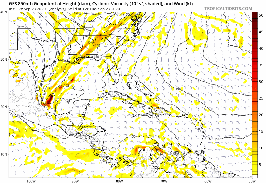
Quite a front heading into the GOM and Florida. I can see why models are really not too enthusiastic on this Western Caribbean system getting strong. Lots of shear and dry air over the GOM and most of Florida:
1 likes
-
SFLcane

- S2K Supporter
- Posts: 10281
- Age: 48
- Joined: Sat Jun 05, 2010 1:44 pm
- Location: Lake Worth Florida
Re: Possible development in Western Caribbean
gatorcane wrote:Quite a front heading into the GOM and Florida. I can see why models are really not too enthusiastic on this Western Caribbean system getting strong. Lots of shear and dry air over the GOM and most of Florida:
https://i.postimg.cc/MZNzHYvL/2-E0-E4-B30-CB48-49-FC-8812-6-A5768-ED5111.gif
Shear will not be a problem in the Caribbean and extreme South Florida.
0 likes
-
SFLcane
- S2K Supporter
- Posts: 10281
- Age: 48
- Joined: Sat Jun 05, 2010 1:44 pm
- Location: Lake Worth Florida
Re: Possible development in Western Caribbean
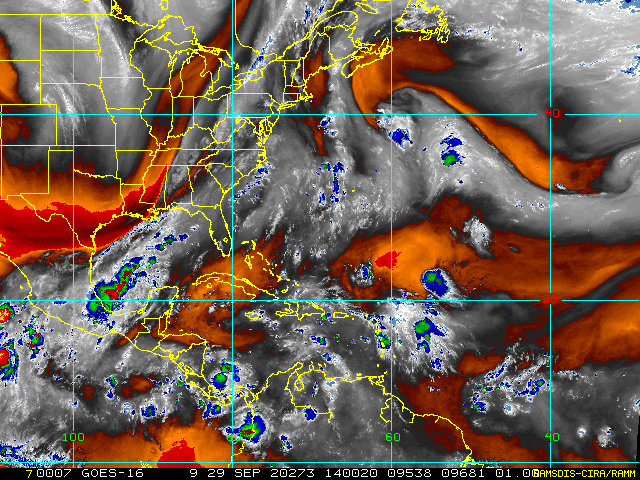
Satellite view this afternoon showing Storms on the increase down in the Caribbean.

0 likes
-
gatorcane
- S2K Supporter
- Posts: 23708
- Age: 48
- Joined: Sun Mar 13, 2005 3:54 pm
- Location: Boca Raton, FL
Re: Possible development in Western Caribbean
The GFS is again into the Yucatán where it looks to get buried:
0 likes
Re: Possible development in Western Caribbean
Yet another Yucutan run from the GFS. It's showing the dominant vorticity coming from the southern end of the wave, and takes a straight NW pass north of Honduras and into Belize. If the dominant vorticity forms further north, future Gamma would have slightly more time to coalesce and intensify.


3 likes
Irene '11 Sandy '12 Hermine '16 5/15/2018 Derecho Fay '20 Isaias '20 Elsa '21 Henri '21 Ida '21
I am only a meteorology enthusiast who knows a decent amount about tropical cyclones. Look to the professional mets, the NHC, or your local weather office for the best information.
I am only a meteorology enthusiast who knows a decent amount about tropical cyclones. Look to the professional mets, the NHC, or your local weather office for the best information.
-
AutoPenalti
- Category 5
- Posts: 4091
- Age: 29
- Joined: Mon Aug 17, 2015 4:16 pm
- Location: Ft. Lauderdale, Florida
Re: Possible development in Western Caribbean
aspen wrote:Yet another Yucutan run from the GFS. It's showing the dominant vorticity coming from the southern end of the wave, and takes a straight NW pass north of Honduras and into Belize. If the dominant vorticity forms further north, future Gamma would have slightly more time to coalesce and intensify.
https://i.imgur.com/Pe85ZaF.png
https://i.imgur.com/D2kCTfM.png
https://i.imgur.com/ZCSFE0N.png
https://i.imgur.com/NcG14Vt.png
https://i.imgur.com/xBJRynx.png
It just doesn't make sense, the northern lobe has been the most active despite the lack of convection. I just don't see how the southern lobe because the dominant one all of the sudden.
3 likes
The posts in this forum are NOT official forecasts and should not be used as such. They are just the opinion of the poster and may or may not be backed by sound meteorological data. They are NOT endorsed by any professional institution or STORM2K. For official information, please refer to products from the NHC and NWS.
Model Runs Cheat Sheet:
GFS (5:30 AM/PM, 11:30 AM/PM)
HWRF, GFDL, UKMET, NAVGEM (6:30-8:00 AM/PM, 12:30-2:00 AM/PM)
ECMWF (1:45 AM/PM)
TCVN is a weighted averaged
Re: Possible development in Western Caribbean
WPC has a big swath of heavy rain over south/east central FL and up off the southeast coast....pretty much confining the heavy rain to the Key west/MIA/MLB CWA regions. it seems like a reasonable solution at this point in time.
https://www.wpc.ncep.noaa.gov/qpf/p168i.gif?1601397746
https://www.wpc.ncep.noaa.gov/qpf/p168i.gif?1601397746
0 likes
-
SFLcane
- S2K Supporter
- Posts: 10281
- Age: 48
- Joined: Sat Jun 05, 2010 1:44 pm
- Location: Lake Worth Florida
Re: Possible development in Western Caribbean
12z CMC with an intensifying cyclone in the northwestern Caribbean Sea moving into the GOM.

3 likes
Who is online
Users browsing this forum: No registered users and 150 guests